Written and Fact-checked by Mukesh Kumar | Updated On: April 256 2026 | 15:50 ET
Map of Steuben County - Steuben County is a county located in the U.S. state of New York. Steuben County Map showing cities, highways, important places and water bodies. Get Where is Steuben County located in the map, major cities in Steuben county, population, areas, and places of interest.
Map of Steuben County, New York
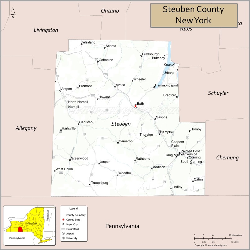
About Steuben County Map, New York: The map showing the county boundary, county seat, major cities, highways, water bodies and neighbouring counties.
Related NY Maps & Info
About Steuben County, New York
Suffolk County is a county located in the U.S. state of New York. It's county seat is Riverhead. As per 2020 census, the population of Suffolk County is 1526344 people and population density is 643.21 square miles. According to the United States Census Bureau, the county has a total area of 2,373 sq mi (6,146 km2). Suffolk County was established on 1683.
Facts about Steuben County, New York
| Country | United States |
| State | New York |
| Region | Southern Tier / Western New York |
| County Seat | Bath |
| Founded | 1796 |
| Named For | Baron von Steuben (Prussian general in the American Revolution) |
| Coordinates | 42.27° N, 77.42° W |
| Total Area | 1,404 sq mi |
| Land Area | 1,391 sq mi |
| Water Area | 14 sq mi |
| Water % | 1.0% |
| Population (2020) | 93,584 |
| Estimated Population (2024) | 92,015 |
| Population Density | 66/sq mi |
| Largest City | Corning |
| Other Major Towns & Communities | Bath, Hornell, Canisteo, Addison, Painted Post |
| Main Industries | Manufacturing (specialty glass), Agriculture, Services, Tourism |
| Major Highways | I‑86 (Southern Tier Expressway), NY‑415, NY‑36, NY‑54, U.S. 15 |
| Time Zone | Eastern Time (UTC−05:00) |
| Known For | Corning Inc. and Corning Museum of Glass, rural landscapes, Southern Tier scenery |
| Website | https://www.steubencountyny.gov/ |
Top Attractions in Steuben County, New York
- Corning Museum of Glass – World-renowned glass exhibits.
- Rockwell Museum – American art collections.
- Finger Lakes Wine Country – Wineries and tastings.
- Keuka Lake – Boating and lake views.
- Hammondsport Village – Shops and lakeside charm.
- Glenn H. Curtiss Museum – Aviation and motorcycle history.
- Mount Washington State Forest – Hiking and forest scenery.
- Erwin Hollow State Forest – Trails and nature views.
- Finger Lakes Boating Museum – Regional boating history.
- Canisteo River – Fishing and paddling.
- Pulteney Park – Village green and events.
- Hornell Area Arts Council Gallery – Local art exhibits.
Cities & Towns in Steuben County, New York
Corning, Hornell, Bath, Painted Post, Avoca, Campbell, Campbell Center, Canisteo, Jasper, Cohocton, Addison, Troupsburg, Wayne, Prattsburgh, Bath Center, Hammondsport, South Corning, Lindley, Erwin, Fremont
- Albany County Map
- Allegany County Map
- Bronx County Map
- Broome County Map
- Cattaraugus County Map
- Cayuga County Map
- Chautauqua County Map
- Chemung County Map
- Chenango County Map
- Clinton County Map
- Columbia County Map
- Cortland County Map
- Delaware County Map
- Dutchess County Map
- Erie County Map
- Essex County Map
- Franklin County Map
- Fulton County Map
- Genesee County Map
- Greene County Map
- Hamilton County Map
- Herkimer County Map
- Jefferson County Map
- Kings County Map
- Lewis County Map
- Livingston County Map
- Madison County Map
- Monroe County Map
- Montgomery County Map
- Nassau County Map
- New York County Map
- Niagara County Map
- Oneida County Map
- Onondaga County Map
- Ontario County Map
- Orange County Map
- Orleans County Map
- Oswego County Map
- Otsego County Map
- Putnam County Map
- Queens County Map
- Rensselaer County Map
- Richmond County Map
- Rockland County Map
- St Lawrence County Map
- Saratoga County Map
- Schenectady County Map
- Schoharie County Map
- Schuyler County Map
- Seneca County Map
- Steuben County Map
- Suffolk County Map
- Sullivan County Map
- Tioga County Map
- Tompkins County Map
- Ulster County Map
- Warren County Map
- Washington County Map
- Wayne County Map
- Westchester County Map
- Wyoming County Map
- Yates County Map
- Alabama Counties
- Alaska boroughs
- Arizona Counties
- Arkansas Counties
- California County Map
- Colorado Counties
- Connecticut Counties
- Delaware Counties
- Florida County Map
- Georgia County Map
- Hawaii Counties
- Idaho Counties
- Illinois Counties
- Indiana Counties
- Iowa Counties
- Kansas Counties
- Kentucky Counties
- Louisiana Counties
- Maine Counties
- Maryland Counties
- Massachusetts Counties
- Michigan County Map
- Minnesota Counties
- Mississippi Counties
- Missouri Counties
- Montana Counties
- Nebraska Counties
- Nevada Counties
- New York Counties
- New Hampshire Counties
- New Jersey Counties
- New Mexico Counties
- North Carolina Counties
- North Dakota Counties
- Ohio County Map
- Oklahoma Counties
- Oregon Counties
- Pennsylvania Counties
- Rhode Island Counties
- South Carolina Counties
- South Dakota Counties
- Map of Tennessee
- Texas County Map
- Utah Counties
- Vermont Counties
- Virginia Counties
- Washington Counties
- West Virginia Counties
- Wisconsin Counties
- Wyoming Counties