Written and Fact-checked by Mukesh Kumar | Updated On: April 256 2026 | 15:50 ET
Map of Otsego County - Otsego County is a county located in the U.S. state of New York. Otsego County Map showing cities, highways, important places and water bodies. Get Where is Otsego County located in the map, major cities in Otsego county, population, areas, and places of interest.
Map of Otsego County, New York
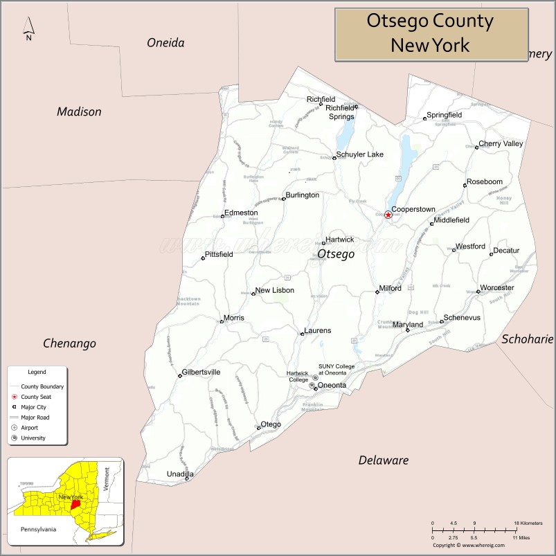
About Otsego County Map, New York: The map showing the county boundary, county seat, major cities, highways, water bodies and neighbouring counties.
Related NY Maps & Info
About Otsego County, New York
Otsego County is a county located in the U.S. state of New York. It's county seat is Cooperstown. As per 2020 census, the population of Otsego County is 58123 people and population density is 57.95 square miles. According to the United States Census Bureau, the county has a total area of 1,003 sq mi (2,598 km2). Otsego County was established on 1791.
Facts about Otsego County, New York
| Country | United States |
| State | New York |
| Region | Central New York / Mohawk Valley |
| County Seat | Cooperstown |
| Founded | February 16, 1791 |
| Named For | Native word *Otsego* (Iroquoian), meaning “place of the rock” or similar |
| Coordinates | 42.62° N, 75.06° W |
| Total Area | 1,016 sq mi |
| Land Area | 1,002 sq mi |
| Water Area | 14 sq mi |
| Water % | 1.4% |
| Population (2020) | 62,259 |
| Estimated Population (2024) | 60,524 |
| Population Density | 60/sq mi |
| Largest City | Oneonta |
| Other Towns & Communities | Cooperstown, Oneonta, Sidney, Richfield Springs, Milford |
| Main Industries | Tourism, Education, Healthcare, Services, Agriculture |
| Major Highways | U.S. 20, NY‑28, NY‑80 |
| Time Zone | Eastern Time (UTC−05:00) |
| Known For | National Baseball Hall of Fame, Cooperstown historic sites, Susquehanna River headwaters, SUNY College at Oneonta |
| Website | https://www.otsegocounty.com/ |
Top Attractions in Otsego County, New York
- National Baseball Hall of Fame and Museum – Baseball history and legends.
- Cooperstown Village – Shops, dining, and charm.
- Glimmerglass State Park – Otsego Lake recreation.
- Fenimore Art Museum – American folk and fine art.
- Farmers’ Museum – Living history and exhibits.
- Otsego Lake – Boating and fishing lake.
- Glimmerglass Festival – Summer opera performances.
- Hyde Hall – Neoclassical lakeside mansion.
- Five Mile Point – Scenic lake overlook.
- Cooperstown Dreams Park – Youth baseball complex.
- Cherry Valley Historic District – Historic village setting.
- Bassett Medical Center Museum – Medical history exhibits.
Cities & Towns in Otsego County, New York
Cooperstown, Oneonta, Cherry Valley, Cooperstown Center, Unadilla, Laurens, Milford, Worcester, Hartwick, Middlefield, Richfield, Otsego, Otego, Burlington, Westford, Maryland, Cherry Valley Center
- Albany County Map
- Allegany County Map
- Bronx County Map
- Broome County Map
- Cattaraugus County Map
- Cayuga County Map
- Chautauqua County Map
- Chemung County Map
- Chenango County Map
- Clinton County Map
- Columbia County Map
- Cortland County Map
- Delaware County Map
- Dutchess County Map
- Erie County Map
- Essex County Map
- Franklin County Map
- Fulton County Map
- Genesee County Map
- Greene County Map
- Hamilton County Map
- Herkimer County Map
- Jefferson County Map
- Kings County Map
- Lewis County Map
- Livingston County Map
- Madison County Map
- Monroe County Map
- Montgomery County Map
- Nassau County Map
- New York County Map
- Niagara County Map
- Oneida County Map
- Onondaga County Map
- Ontario County Map
- Orange County Map
- Orleans County Map
- Oswego County Map
- Otsego County Map
- Putnam County Map
- Queens County Map
- Rensselaer County Map
- Richmond County Map
- Rockland County Map
- St Lawrence County Map
- Saratoga County Map
- Schenectady County Map
- Schoharie County Map
- Schuyler County Map
- Seneca County Map
- Steuben County Map
- Suffolk County Map
- Sullivan County Map
- Tioga County Map
- Tompkins County Map
- Ulster County Map
- Warren County Map
- Washington County Map
- Wayne County Map
- Westchester County Map
- Wyoming County Map
- Yates County Map
- Alabama Counties
- Alaska boroughs
- Arizona Counties
- Arkansas Counties
- California County Map
- Colorado Counties
- Connecticut Counties
- Delaware Counties
- Florida County Map
- Georgia County Map
- Hawaii Counties
- Idaho Counties
- Illinois Counties
- Indiana Counties
- Iowa Counties
- Kansas Counties
- Kentucky Counties
- Louisiana Counties
- Maine Counties
- Maryland Counties
- Massachusetts Counties
- Michigan County Map
- Minnesota Counties
- Mississippi Counties
- Missouri Counties
- Montana Counties
- Nebraska Counties
- Nevada Counties
- New York Counties
- New Hampshire Counties
- New Jersey Counties
- New Mexico Counties
- North Carolina Counties
- North Dakota Counties
- Ohio County Map
- Oklahoma Counties
- Oregon Counties
- Pennsylvania Counties
- Rhode Island Counties
- South Carolina Counties
- South Dakota Counties
- Map of Tennessee
- Texas County Map
- Utah Counties
- Vermont Counties
- Virginia Counties
- Washington Counties
- West Virginia Counties
- Wisconsin Counties
- Wyoming Counties