Written and Fact-checked by Mukesh Kumar | Updated On: April 256 2026 | 15:50 ET
Map of Jefferson County - Jefferson County is a county located in the U.S. state of New York. Jefferson County Map showing cities, highways, important places and water bodies. Get Where is Jefferson County located in the map, major cities in Jefferson county, population, areas, and places of interest.
Map of Jefferson County, New York
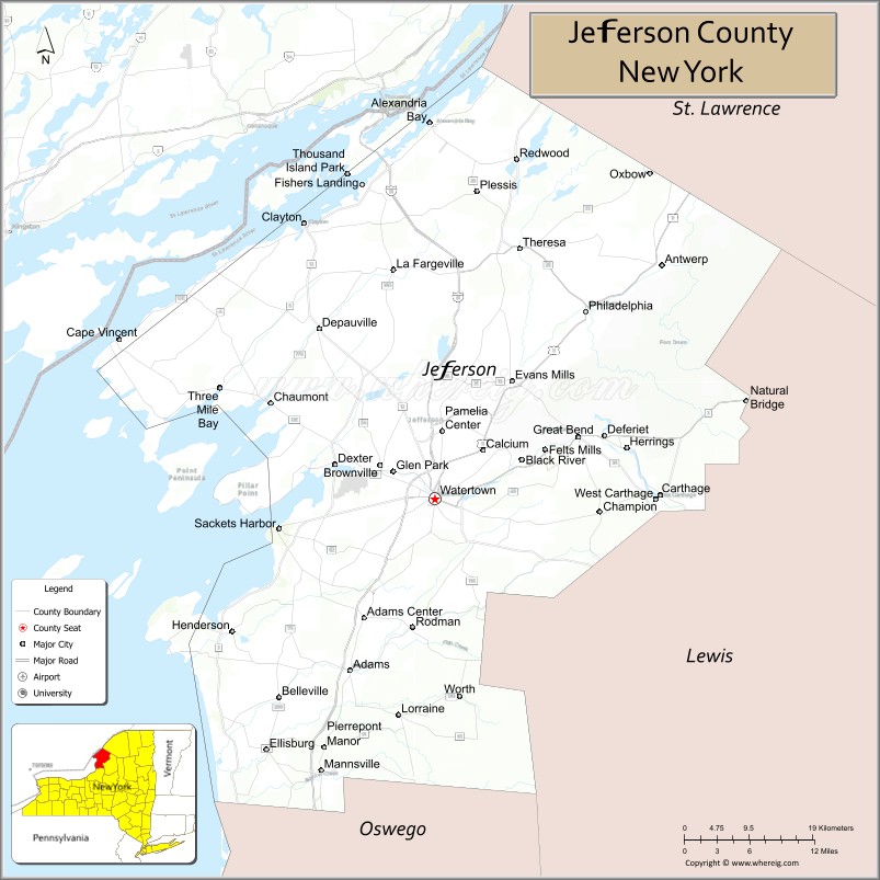
About Jefferson County Map, New York: The map showing the county boundary, county seat, major cities, highways, water bodies and neighbouring counties.
Related NY Maps & Info
About Jefferson County, New York
Jefferson County is a county located in the U.S. state of New York. It's county seat is Watertown. As per 2020 census, the population of Jefferson County is 116295 people and population density is 62.63 square miles. According to the United States Census Bureau, the county has a total area of 1,857 sq mi (4,810 km2). Jefferson County was established on 1805.
Facts about Jefferson County, New York
| Country | United States |
| State | New York |
| Region | Northern New York / North Country |
| County Seat | Watertown |
| Founded | March 18, 1805 |
| Named For | Thomas Jefferson (third U.S. President) |
| Coordinates | 44.00° N, 75.99° W |
| Total Area | 1,857 sq mi |
| Land Area | 1,269 sq mi |
| Water Area | 588 sq mi |
| Water % | 32% |
| Population (2020) | 116,721 |
| Estimated Population (2024) | 114,787 |
| Population Density | 92/sq mi |
| Largest Municipality | Watertown |
| Other Towns & Communities | Adams, Alexandria Bay, Carthage, Clayton, Sackets Harbor |
| Main Industries | Military (Fort Drum), Tourism, Agriculture, Services |
| Major Highways | I‑81, U.S. 11, NY‑3, NY‑12, NY‑180 |
| Time Zone | Eastern Time (UTC−05:00) |
| Known For | Fort Drum military base, Thousand Islands & St. Lawrence River, Black River, outdoor recreation |
| Website | https://www.jeffersoncountyny.gov/ |
Top Attractions in Jefferson County, New York
- Thousand Islands Region – Scenic islands and boat tours.
- Boldt Castle – Iconic castle on Heart Island.
- Sackets Harbor Battlefield – War of 1812 historic site.
- Watertown Public Square – Downtown shops and dining.
- Fort Drum Military Museum – U.S. Army history exhibits.
- Black River – Fishing and paddling river.
- Thompson Park – Zoo, trails, and city views.
- Jefferson County Historical Society – Local history museum.
- Sandy Pond – Fishing and waterfront recreation.
- Southwick Beach State Park – Sandy Lake Ontario beach.
- Antwerp Village Historic Area – Small-town historic charm.
- Cape Vincent Lighthouse – Scenic lighthouse views.
Cities & Towns in Jefferson County, New York
Watertown, Adams, Carthage, Cape Vincent, Alexandria Bay, Black River, Sackets Harbor, Clayton, Lyme, Champion, Le Ray, Lorraine, Pamelia, Theresa, Hounsfield, Orleans, Champion Center, Antwerp, La Fargeville
- Albany County Map
- Allegany County Map
- Bronx County Map
- Broome County Map
- Cattaraugus County Map
- Cayuga County Map
- Chautauqua County Map
- Chemung County Map
- Chenango County Map
- Clinton County Map
- Columbia County Map
- Cortland County Map
- Delaware County Map
- Dutchess County Map
- Erie County Map
- Essex County Map
- Franklin County Map
- Fulton County Map
- Genesee County Map
- Greene County Map
- Hamilton County Map
- Herkimer County Map
- Jefferson County Map
- Kings County Map
- Lewis County Map
- Livingston County Map
- Madison County Map
- Monroe County Map
- Montgomery County Map
- Nassau County Map
- New York County Map
- Niagara County Map
- Oneida County Map
- Onondaga County Map
- Ontario County Map
- Orange County Map
- Orleans County Map
- Oswego County Map
- Otsego County Map
- Putnam County Map
- Queens County Map
- Rensselaer County Map
- Richmond County Map
- Rockland County Map
- St Lawrence County Map
- Saratoga County Map
- Schenectady County Map
- Schoharie County Map
- Schuyler County Map
- Seneca County Map
- Steuben County Map
- Suffolk County Map
- Sullivan County Map
- Tioga County Map
- Tompkins County Map
- Ulster County Map
- Warren County Map
- Washington County Map
- Wayne County Map
- Westchester County Map
- Wyoming County Map
- Yates County Map
- Alabama Counties
- Alaska boroughs
- Arizona Counties
- Arkansas Counties
- California County Map
- Colorado Counties
- Connecticut Counties
- Delaware Counties
- Florida County Map
- Georgia County Map
- Hawaii Counties
- Idaho Counties
- Illinois Counties
- Indiana Counties
- Iowa Counties
- Kansas Counties
- Kentucky Counties
- Louisiana Counties
- Maine Counties
- Maryland Counties
- Massachusetts Counties
- Michigan County Map
- Minnesota Counties
- Mississippi Counties
- Missouri Counties
- Montana Counties
- Nebraska Counties
- Nevada Counties
- New York Counties
- New Hampshire Counties
- New Jersey Counties
- New Mexico Counties
- North Carolina Counties
- North Dakota Counties
- Ohio County Map
- Oklahoma Counties
- Oregon Counties
- Pennsylvania Counties
- Rhode Island Counties
- South Carolina Counties
- South Dakota Counties
- Map of Tennessee
- Texas County Map
- Utah Counties
- Vermont Counties
- Virginia Counties
- Washington Counties
- West Virginia Counties
- Wisconsin Counties
- Wyoming Counties