Written and Fact-checked by Mukesh Kumar | Updated On: April 256 2026 | 15:50 ET
Map of Niagara County - Niagara County is a county located in the U.S. state of New York. Niagara County Map showing cities, highways, important places and water bodies. Get Where is Niagara County located in the map, major cities in Niagara county, population, areas, and places of interest.
Map of Niagara County, New York
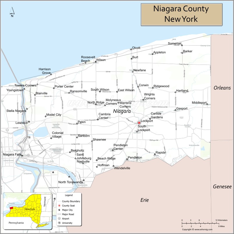
About Niagara County Map, New York: The map showing the county boundary, county seat, major cities, highways, water bodies and neighbouring counties.
Related NY Maps & Info
About Niagara County, New York
Niagara County is a county located in the U.S. state of New York. It's county seat is Lockport. As per 2020 census, the population of Niagara County is 211653 people and population density is 185.66 square miles. According to the United States Census Bureau, the county has a total area of 1,140 sq mi (2,953 km2). Niagara County was established on 1808.
Facts about Niagara County, New York
| Country | United States |
| State | New York |
| Region | Western New York / Lake Ontario & Niagara Frontier |
| County Seat | Lockport |
| Founded | March 11, 1808 |
| Named For | Iroquois word *Onguiaahra* meaning “the strait” or “thunder of waters” (referring to Niagara Falls) |
| Coordinates | 43.22° N, 78.69° W |
| Total Area | 1,139 sq mi |
| Land Area | 522 sq mi |
| Water Area | 617 sq mi |
| Water % | 54% |
| Population (2020) | 212,666 |
| Estimated Population (2024) | 210,000+ |
| Population Density | 407/sq mi (land area) |
| Largest City | Niagara Falls |
| Other Cities & Towns | Lockport, North Tonawanda, Wheatfield, Lewiston, Sanborn, Newfane, Barker |
| Main Industries | Tourism, Hydropower, Agriculture, Wine production, Services |
| Major Highways | I‑190, NY‑31, NY‑78, NY‑104 |
| Time Zone | Eastern Time (UTC−05:00) |
| Known For | Niagara Falls, Niagara River, Lake Ontario shoreline, Niagara Wine Trail, outdoor & historic attractions |
| Website | https://www.niagaracounty.gov/ |
Top Attractions in Niagara County, New York
- Niagara Falls State Park – Iconic waterfalls and viewpoints.
- Niagara Falls – World-famous natural wonder.
- Fort Niagara State Park – Historic military fort.
- Niagara Falls Underground Railroad Heritage Center – Freedom history exhibits.
- Whirlpool State Park – Scenic gorge trails.
- Niagara Falls Aquarium – Aquatic exhibits and shows.
- Devils Hole State Park – Hiking and river views.
- Old Fort Niagara Lighthouse – Historic lighthouse views.
- Niagara Falls Culinary Institute – Dining and culinary experiences.
- Lockport Locks & Erie Canal Cruises – Canal boat tours.
- Olcott Beach & Pier – Lake Ontario waterfront.
- Niagara Wine Trail – Wineries and tastings.
Cities & Towns in Niagara County, New York
Niagara Falls, Lockport, North Tonawanda, Youngstown, Lewiston, Wheatfield, Sanborn, Niagara, Newfane, Cambria, Hartland, Royalton, Wilson, Pendleton, Barker, Porter, Wilson Beach, Olcott
- Albany County Map
- Allegany County Map
- Bronx County Map
- Broome County Map
- Cattaraugus County Map
- Cayuga County Map
- Chautauqua County Map
- Chemung County Map
- Chenango County Map
- Clinton County Map
- Columbia County Map
- Cortland County Map
- Delaware County Map
- Dutchess County Map
- Erie County Map
- Essex County Map
- Franklin County Map
- Fulton County Map
- Genesee County Map
- Greene County Map
- Hamilton County Map
- Herkimer County Map
- Jefferson County Map
- Kings County Map
- Lewis County Map
- Livingston County Map
- Madison County Map
- Monroe County Map
- Montgomery County Map
- Nassau County Map
- New York County Map
- Niagara County Map
- Oneida County Map
- Onondaga County Map
- Ontario County Map
- Orange County Map
- Orleans County Map
- Oswego County Map
- Otsego County Map
- Putnam County Map
- Queens County Map
- Rensselaer County Map
- Richmond County Map
- Rockland County Map
- St Lawrence County Map
- Saratoga County Map
- Schenectady County Map
- Schoharie County Map
- Schuyler County Map
- Seneca County Map
- Steuben County Map
- Suffolk County Map
- Sullivan County Map
- Tioga County Map
- Tompkins County Map
- Ulster County Map
- Warren County Map
- Washington County Map
- Wayne County Map
- Westchester County Map
- Wyoming County Map
- Yates County Map
- Alabama Counties
- Alaska boroughs
- Arizona Counties
- Arkansas Counties
- California County Map
- Colorado Counties
- Connecticut Counties
- Delaware Counties
- Florida County Map
- Georgia County Map
- Hawaii Counties
- Idaho Counties
- Illinois Counties
- Indiana Counties
- Iowa Counties
- Kansas Counties
- Kentucky Counties
- Louisiana Counties
- Maine Counties
- Maryland Counties
- Massachusetts Counties
- Michigan County Map
- Minnesota Counties
- Mississippi Counties
- Missouri Counties
- Montana Counties
- Nebraska Counties
- Nevada Counties
- New York Counties
- New Hampshire Counties
- New Jersey Counties
- New Mexico Counties
- North Carolina Counties
- North Dakota Counties
- Ohio County Map
- Oklahoma Counties
- Oregon Counties
- Pennsylvania Counties
- Rhode Island Counties
- South Carolina Counties
- South Dakota Counties
- Map of Tennessee
- Texas County Map
- Utah Counties
- Vermont Counties
- Virginia Counties
- Washington Counties
- West Virginia Counties
- Wisconsin Counties
- Wyoming Counties