Written and Fact-checked by Mukesh Kumar | Updated On: April 256 2026 | 15:50 ET
Map of Nassau County - Nassau County is a county located in the U.S. state of New York. Nassau County Map showing cities, highways, important places and water bodies. Get Where is Nassau County located in the map, major cities in Nassau county, population, areas, and places of interest.
Map of Nassau County, New York
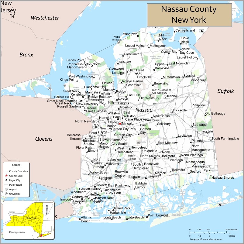
About Nassau County Map, New York: The map showing the county boundary, county seat, major cities, highways, water bodies and neighbouring counties.
Related NY Maps & Info
About Nassau County, New York
Nassau County is a county located in the U.S. state of New York. It's county seat is Mineola. As per 2020 census, the population of Nassau County is 1390907 people and population density is 3070.43 square miles. According to the United States Census Bureau, the county has a total area of 453 sq mi (1,173 km2). Nassau County was established on 1899.
Facts about Nassau County, New York
| Country | United States |
| State | New York |
| Region | Long Island / New York Metropolitan Area |
| County Seat | Mineola |
| Founded | 1899 (effective Jan 1) |
| Named For | House of Nassau |
| Coordinates | 40.72° N, 73.63° W |
| Total Area | 453 sq mi |
| Land Area | 285 sq mi |
| Water Area | 169 sq mi |
| Water % | 37% |
| Population (2020) | 1,395,774 |
| Estimated Population (2024) | 1,392,438 |
| Population Density | 4,800 /sq mi (land area) |
| Largest Municipality | Hempstead (town) |
| Other Major Communities | Oyster Bay, North Hempstead, Glen Cove, Long Beach |
| Main Industries | Services, Healthcare, Education, Retail, Technology |
| Major Highways | I‑495, Northern State Pkwy, Southern State Pkwy, NY‑25, NY‑135 |
| Time Zone | Eastern Time (UTC−05:00) |
| Known For | Affluent suburbs, Long Island Sound & Atlantic Ocean coastline, parks & beaches, close NYC commuter links |
| Website | https://www.nassaucountyny.gov/ |
Top Attractions in Nassau County, New York
- Jones Beach State Park – Ocean beach and boardwalk.
- Old Westbury Gardens – Historic mansion and gardens.
- Nassau County Museum of Art – Art museum and grounds.
- Planting Fields Arboretum – Arboretum and historic estate.
- Cradle of Aviation Museum – Aviation and space history.
- Long Beach Boardwalk – Beachfront walking path.
- Belmont Park – Famous horse racing track.
- Sands Point Preserve – Waterfront estates and trails.
- Port Washington Waterfront – Harbor views and dining.
- Oyster Bay Historic Area – Theodore Roosevelt history.
- Garvies Point Museum – Geology and Native American history.
- Eisenhower Park – Large park and recreation.
Cities & Towns in Nassau County, New York
Hempstead, Garden City, Glen Cove, Long Beach, Freeport, Rockville Centre, Valley Stream, Oceanside, Baldwin, Levittown, Floral Park, Lynbrook, Westbury, Mineola, Wantagh, Massapequa, Merrick, Carle Place, Elmont, Bellmore
- Albany County Map
- Allegany County Map
- Bronx County Map
- Broome County Map
- Cattaraugus County Map
- Cayuga County Map
- Chautauqua County Map
- Chemung County Map
- Chenango County Map
- Clinton County Map
- Columbia County Map
- Cortland County Map
- Delaware County Map
- Dutchess County Map
- Erie County Map
- Essex County Map
- Franklin County Map
- Fulton County Map
- Genesee County Map
- Greene County Map
- Hamilton County Map
- Herkimer County Map
- Jefferson County Map
- Kings County Map
- Lewis County Map
- Livingston County Map
- Madison County Map
- Monroe County Map
- Montgomery County Map
- Nassau County Map
- New York County Map
- Niagara County Map
- Oneida County Map
- Onondaga County Map
- Ontario County Map
- Orange County Map
- Orleans County Map
- Oswego County Map
- Otsego County Map
- Putnam County Map
- Queens County Map
- Rensselaer County Map
- Richmond County Map
- Rockland County Map
- St Lawrence County Map
- Saratoga County Map
- Schenectady County Map
- Schoharie County Map
- Schuyler County Map
- Seneca County Map
- Steuben County Map
- Suffolk County Map
- Sullivan County Map
- Tioga County Map
- Tompkins County Map
- Ulster County Map
- Warren County Map
- Washington County Map
- Wayne County Map
- Westchester County Map
- Wyoming County Map
- Yates County Map
- Alabama Counties
- Alaska boroughs
- Arizona Counties
- Arkansas Counties
- California County Map
- Colorado Counties
- Connecticut Counties
- Delaware Counties
- Florida County Map
- Georgia County Map
- Hawaii Counties
- Idaho Counties
- Illinois Counties
- Indiana Counties
- Iowa Counties
- Kansas Counties
- Kentucky Counties
- Louisiana Counties
- Maine Counties
- Maryland Counties
- Massachusetts Counties
- Michigan County Map
- Minnesota Counties
- Mississippi Counties
- Missouri Counties
- Montana Counties
- Nebraska Counties
- Nevada Counties
- New York Counties
- New Hampshire Counties
- New Jersey Counties
- New Mexico Counties
- North Carolina Counties
- North Dakota Counties
- Ohio County Map
- Oklahoma Counties
- Oregon Counties
- Pennsylvania Counties
- Rhode Island Counties
- South Carolina Counties
- South Dakota Counties
- Map of Tennessee
- Texas County Map
- Utah Counties
- Vermont Counties
- Virginia Counties
- Washington Counties
- West Virginia Counties
- Wisconsin Counties
- Wyoming Counties