Written and Fact-checked by Mukesh Kumar | Updated On: April 256 2026 | 15:50 ET
Map of Broome County - Broome County is a county located in the U.S. state of New York. Broome County Map showing cities, highways, important places and water bodies. Get Where is Broome County located in the map, major cities in Broome county, population, areas, and places of interest.
Map of Broome County, New York
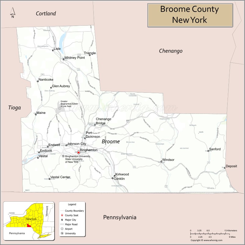
About Broome County Map, New York: The map showing the county boundary, county seat, major cities, highways, water bodies and neighbouring counties.
Related NY Maps & Info
About Broome County, New York
Broome County is a county located in the U.S. state of New York. It's county seat is Binghamton. As per 2020 census, the population of Broome County is 197240 people and population density is 275.86 square miles. According to the United States Census Bureau, the county has a total area of 715 sq mi (1,852 km2). Broome County was established on 1806.
Facts about Broome County, New York
| Country | United States |
| State | New York |
| Region | Southern Tier / South‑Central New York |
| County Seat | Binghamton |
| Founded | March 28, 1806 |
| Named For | John Broome, Lieutenant Governor of New York |
| Coordinates | 42.17° N, 75.85° W |
| Total Area | 716 sq mi |
| Land Area | 706 sq mi |
| Water Area | 9.7 sq mi |
| Water % | 1.4% |
| Population (2020) | 198,683 |
| Estimated Population (2024) | 197,700+ |
| Population Density | 281/sq mi |
| Largest City | Binghamton |
| Other Communities | Vestal, Endicott, Johnson City, Kirkwood, Windsor |
| Main Industries | Manufacturing, Education, Healthcare, Services |
| Major Highways | I‑81, I‑86/NY‑17, U.S. 11, NY‑7, NY‑17C |
| Time Zone | Eastern Time (UTC−05:00) |
| Known For | Binghamton University, historical electronics manufacturing, Susquehanna & Chenango Rivers |
| Website | https://www.gobroomecounty.com/ |
Top Attractions in Broome County, New York
- Roberson Museum and Science Center – Art, history, and science exhibits.
- Ross Park Zoo – Small historic zoo with animals.
- Chenango Valley State Park – Hiking, camping, and lake recreation.
- Discovery Center of the Southern Tier – Hands-on children’s museum.
- Bundy Museum of History & Art – Local history and rotating art.
- Otsiningo Park – Riverside park with trails and events.
- Binghamton University Nature Preserve – Wooded trails and wetlands.
- Cutler Botanic Garden – Botanical gardens and greenhouses.
- NYSEG Stadium – Minor league baseball park.
- Downtown Binghamton – Restaurants, nightlife, and culture.
- IBM Glen – Forested park with walking paths.
- Chenango River – Fishing and paddling waterway.
Cities & Towns in Broome County, New York
Binghamton, Johnson City, Endicott, Vestal, Conklin, Kirkwood, Chenango Bridge, Lisle, Whitney Point, Maine, Port Dickinson, Fenton, Sanford, Barker, Triangle, Barker Heights
- Albany County Map
- Allegany County Map
- Bronx County Map
- Broome County Map
- Cattaraugus County Map
- Cayuga County Map
- Chautauqua County Map
- Chemung County Map
- Chenango County Map
- Clinton County Map
- Columbia County Map
- Cortland County Map
- Delaware County Map
- Dutchess County Map
- Erie County Map
- Essex County Map
- Franklin County Map
- Fulton County Map
- Genesee County Map
- Greene County Map
- Hamilton County Map
- Herkimer County Map
- Jefferson County Map
- Kings County Map
- Lewis County Map
- Livingston County Map
- Madison County Map
- Monroe County Map
- Montgomery County Map
- Nassau County Map
- New York County Map
- Niagara County Map
- Oneida County Map
- Onondaga County Map
- Ontario County Map
- Orange County Map
- Orleans County Map
- Oswego County Map
- Otsego County Map
- Putnam County Map
- Queens County Map
- Rensselaer County Map
- Richmond County Map
- Rockland County Map
- St Lawrence County Map
- Saratoga County Map
- Schenectady County Map
- Schoharie County Map
- Schuyler County Map
- Seneca County Map
- Steuben County Map
- Suffolk County Map
- Sullivan County Map
- Tioga County Map
- Tompkins County Map
- Ulster County Map
- Warren County Map
- Washington County Map
- Wayne County Map
- Westchester County Map
- Wyoming County Map
- Yates County Map
- Alabama Counties
- Alaska boroughs
- Arizona Counties
- Arkansas Counties
- California County Map
- Colorado Counties
- Connecticut Counties
- Delaware Counties
- Florida County Map
- Georgia County Map
- Hawaii Counties
- Idaho Counties
- Illinois Counties
- Indiana Counties
- Iowa Counties
- Kansas Counties
- Kentucky Counties
- Louisiana Counties
- Maine Counties
- Maryland Counties
- Massachusetts Counties
- Michigan County Map
- Minnesota Counties
- Mississippi Counties
- Missouri Counties
- Montana Counties
- Nebraska Counties
- Nevada Counties
- New York Counties
- New Hampshire Counties
- New Jersey Counties
- New Mexico Counties
- North Carolina Counties
- North Dakota Counties
- Ohio County Map
- Oklahoma Counties
- Oregon Counties
- Pennsylvania Counties
- Rhode Island Counties
- South Carolina Counties
- South Dakota Counties
- Map of Tennessee
- Texas County Map
- Utah Counties
- Vermont Counties
- Virginia Counties
- Washington Counties
- West Virginia Counties
- Wisconsin Counties
- Wyoming Counties