Written and Fact-checked by Mukesh Kumar | Updated On: April 256 2026 | 15:50 ET
Map of Montgomery County - Montgomery County is a county located in the U.S. state of New York. Montgomery County Map showing cities, highways, important places and water bodies. Get Where is Montgomery County located in the map, major cities in Montgomery county, population, areas, and places of interest.
Map of Montgomery County, New York
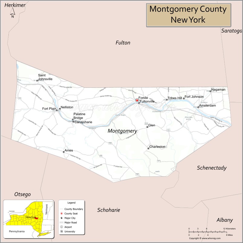
About Montgomery County Map, New York: The map showing the county boundary, county seat, major cities, highways, water bodies and neighbouring counties.
Related NY Maps & Info
About Montgomery County, New York
Montgomery County is a county located in the U.S. state of New York. It's county seat is Fonda. As per 2020 census, the population of Montgomery County is 49558 people and population density is 120.87 square miles. According to the United States Census Bureau, the county has a total area of 410 sq mi (1,062 km2). Montgomery County was established on 1772.
Facts about Montgomery County, New York
| Country | United States |
| State | New York |
| Region | Central New York / Mohawk Valley |
| County Seat | Fonda |
| Founded | March 12, 1772 |
| Named For | General Richard Montgomery (Revolutionary War hero) |
| Coordinates | 42.94° N, 74.50° W |
| Total Area | 410 sq mi |
| Land Area | 403 sq mi |
| Water Area | 7.3 sq mi |
| Water % | 1.8% |
| Population (2020) | 49,532 |
| Estimated Population (2024) | 49,648 |
| Population Density | 123/sq mi |
| Largest City | Amsterdam |
| Other Towns & Communities | Canajoharie, Fort Plain, Fonda, Nelliston, Fort Johnson, Hagaman, Palatine Bridge, St. Johnsville |
| Main Industries | Manufacturing, Services, Agriculture, Tourism |
| Major Highways | I‑90, U.S. 30, NY‑5S |
| Time Zone | Eastern Time (UTC−05:00) |
| Known For | Mohawk River & Erie Canal heritage, historic Dutch and colonial sites, scenic countryside |
| Website | https://www.montgomerycountyny.gov/ |
Top Attractions in Montgomery County, New York
- Amsterdam Riverfront – Mohawk River views and parks.
- Old Fort Johnson National Historic Site – Colonial-era stone house.
- Mohawk Valley Gateway Overlook – Scenic valley viewpoint.
- Schoharie Creek Aqueduct – Historic Erie Canal structure.
- Fort Plain Museum – Mohawk Valley history exhibits.
- Amsterdam Castle – Historic armory-style building.
- Walter Elwood Museum – Local history and artifacts.
- Mohawk River – Fishing and paddling waterway.
- Riverlink Park – Downtown riverfront park.
- Tribes Hill Historic Area – Early settlement history.
- Canajoharie Falls (nearby) – Scenic waterfall area.
- Erie Canalway Trail – Walking and biking trail.
Cities & Towns in Montgomery County, New York
Fonda, Amsterdam, Canajoharie, St. Johnsville, Palatine Bridge, Fort Plain, Tribes Hill, Sprakers, Fultonville, Charleston, Root, Glen, Minden, Mohawk, Ephratah, Nelliston
- Albany County Map
- Allegany County Map
- Bronx County Map
- Broome County Map
- Cattaraugus County Map
- Cayuga County Map
- Chautauqua County Map
- Chemung County Map
- Chenango County Map
- Clinton County Map
- Columbia County Map
- Cortland County Map
- Delaware County Map
- Dutchess County Map
- Erie County Map
- Essex County Map
- Franklin County Map
- Fulton County Map
- Genesee County Map
- Greene County Map
- Hamilton County Map
- Herkimer County Map
- Jefferson County Map
- Kings County Map
- Lewis County Map
- Livingston County Map
- Madison County Map
- Monroe County Map
- Montgomery County Map
- Nassau County Map
- New York County Map
- Niagara County Map
- Oneida County Map
- Onondaga County Map
- Ontario County Map
- Orange County Map
- Orleans County Map
- Oswego County Map
- Otsego County Map
- Putnam County Map
- Queens County Map
- Rensselaer County Map
- Richmond County Map
- Rockland County Map
- St Lawrence County Map
- Saratoga County Map
- Schenectady County Map
- Schoharie County Map
- Schuyler County Map
- Seneca County Map
- Steuben County Map
- Suffolk County Map
- Sullivan County Map
- Tioga County Map
- Tompkins County Map
- Ulster County Map
- Warren County Map
- Washington County Map
- Wayne County Map
- Westchester County Map
- Wyoming County Map
- Yates County Map
- Alabama Counties
- Alaska boroughs
- Arizona Counties
- Arkansas Counties
- California County Map
- Colorado Counties
- Connecticut Counties
- Delaware Counties
- Florida County Map
- Georgia County Map
- Hawaii Counties
- Idaho Counties
- Illinois Counties
- Indiana Counties
- Iowa Counties
- Kansas Counties
- Kentucky Counties
- Louisiana Counties
- Maine Counties
- Maryland Counties
- Massachusetts Counties
- Michigan County Map
- Minnesota Counties
- Mississippi Counties
- Missouri Counties
- Montana Counties
- Nebraska Counties
- Nevada Counties
- New York Counties
- New Hampshire Counties
- New Jersey Counties
- New Mexico Counties
- North Carolina Counties
- North Dakota Counties
- Ohio County Map
- Oklahoma Counties
- Oregon Counties
- Pennsylvania Counties
- Rhode Island Counties
- South Carolina Counties
- South Dakota Counties
- Map of Tennessee
- Texas County Map
- Utah Counties
- Vermont Counties
- Virginia Counties
- Washington Counties
- West Virginia Counties
- Wisconsin Counties
- Wyoming Counties