Written and Fact-checked by Mukesh Kumar | Updated On: April 256 2026 | 15:50 ET
Map of Kings County - Kings County is a county located in the U.S. state of New York. Kings County Map showing cities, highways, important places and water bodies. Get Where is Kings County located in the map, major cities in Kings county, population, areas, and places of interest.
Map of Kings County, New York
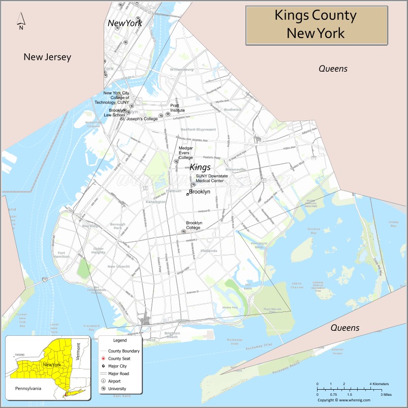
About Kings County Map, New York: The map showing the county boundary, county seat, major cities, highways, water bodies and neighbouring counties.
Related NY Maps & Info
About Kings County, New York
Kings County is a county located in the U.S. state of New York. It's county seat is none (sui generis). As per 2020 census, the population of Kings County is 2641052 people and population density is 27255.44 square miles. According to the United States Census Bureau, the county has a total area of 96.9 sq mi (251 km2). Kings County was established on 1683.
Facts about Kings County, New York
| Country | United States |
| State | New York |
| Region | New York City / Southern New York |
| County Seat | Brooklyn (coextensive) |
| Founded | 1683 |
| Named For | King Charles II of England |
| Coordinates | 40.68° N, 73.94° W |
| Total Area | 97 sq mi |
| Land Area | 69 sq mi |
| Water Area | 28 sq mi |
| Water % | 29% |
| Population (2020) | 2,736,074 |
| Estimated Population (2023) | 2,646,306 |
| Population Density | 39,000/sq mi (land) |
| Largest Municipality | Brooklyn |
| Other Neighborhoods | Williamsburg, Bay Ridge, Park Slope, Bushwick, Coney Island |
| Main Industries | Services, Finance, Media, Healthcare, Education |
| Major Highways | I‑278 (BQE), NY‑27, NY‑878 |
| Time Zone | Eastern Time (UTC−05:00) |
| Known For | Cultural diversity, Brooklyn Bridge, Coney Island, Prospect Park, arts & cuisine |
| Website | https://www.nyc.gov/boroughs/brooklyn |
Top Attractions in Kings County, New York
- Brooklyn Bridge – Iconic bridge and skyline views.
- Prospect Park – Large urban park and green space.
- Brooklyn Museum – Art and cultural exhibitions.
- Brooklyn Botanic Garden – Themed gardens and conservatory.
- Coney Island – Beach, boardwalk, and amusement rides.
- Barclays Center – Sports and concert arena.
- Williamsburg Waterfront – River views and nightlife.
- Brooklyn Heights Promenade – Scenic walkway overlooking Manhattan.
- New York Transit Museum – Subway and transit history.
- Prospect Park Zoo – Family-friendly zoo.
- DUMBO Historic District – Cobblestone streets and views.
- Brooklyn Navy Yard – Historic industrial waterfront.
Cities & Towns in Kings County, New York
Brooklyn, Flatbush, Williamsburg, Bushwick, Bedford-Stuyvesant, Crown Heights, Bay Ridge, Bensonhurst, Park Slope, Sunset Park, Greenpoint, East New York, Brownsville, Canarsie, Gravesend, Brighton Beach
- Albany County Map
- Allegany County Map
- Bronx County Map
- Broome County Map
- Cattaraugus County Map
- Cayuga County Map
- Chautauqua County Map
- Chemung County Map
- Chenango County Map
- Clinton County Map
- Columbia County Map
- Cortland County Map
- Delaware County Map
- Dutchess County Map
- Erie County Map
- Essex County Map
- Franklin County Map
- Fulton County Map
- Genesee County Map
- Greene County Map
- Hamilton County Map
- Herkimer County Map
- Jefferson County Map
- Kings County Map
- Lewis County Map
- Livingston County Map
- Madison County Map
- Monroe County Map
- Montgomery County Map
- Nassau County Map
- New York County Map
- Niagara County Map
- Oneida County Map
- Onondaga County Map
- Ontario County Map
- Orange County Map
- Orleans County Map
- Oswego County Map
- Otsego County Map
- Putnam County Map
- Queens County Map
- Rensselaer County Map
- Richmond County Map
- Rockland County Map
- St Lawrence County Map
- Saratoga County Map
- Schenectady County Map
- Schoharie County Map
- Schuyler County Map
- Seneca County Map
- Steuben County Map
- Suffolk County Map
- Sullivan County Map
- Tioga County Map
- Tompkins County Map
- Ulster County Map
- Warren County Map
- Washington County Map
- Wayne County Map
- Westchester County Map
- Wyoming County Map
- Yates County Map
- Alabama Counties
- Alaska boroughs
- Arizona Counties
- Arkansas Counties
- California County Map
- Colorado Counties
- Connecticut Counties
- Delaware Counties
- Florida County Map
- Georgia County Map
- Hawaii Counties
- Idaho Counties
- Illinois Counties
- Indiana Counties
- Iowa Counties
- Kansas Counties
- Kentucky Counties
- Louisiana Counties
- Maine Counties
- Maryland Counties
- Massachusetts Counties
- Michigan County Map
- Minnesota Counties
- Mississippi Counties
- Missouri Counties
- Montana Counties
- Nebraska Counties
- Nevada Counties
- New York Counties
- New Hampshire Counties
- New Jersey Counties
- New Mexico Counties
- North Carolina Counties
- North Dakota Counties
- Ohio County Map
- Oklahoma Counties
- Oregon Counties
- Pennsylvania Counties
- Rhode Island Counties
- South Carolina Counties
- South Dakota Counties
- Map of Tennessee
- Texas County Map
- Utah Counties
- Vermont Counties
- Virginia Counties
- Washington Counties
- West Virginia Counties
- Wisconsin Counties
- Wyoming Counties