Written and Fact-checked by Mukesh Kumar | Updated On: April 256 2026 | 15:50 ET
Map of Franklin County - Franklin County is a county located in the U.S. state of New York. Franklin County Map showing cities, highways, important places and water bodies. Get Where is Franklin County located in the map, major cities in Franklin county, population, areas, and places of interest.
Map of Franklin County, New York
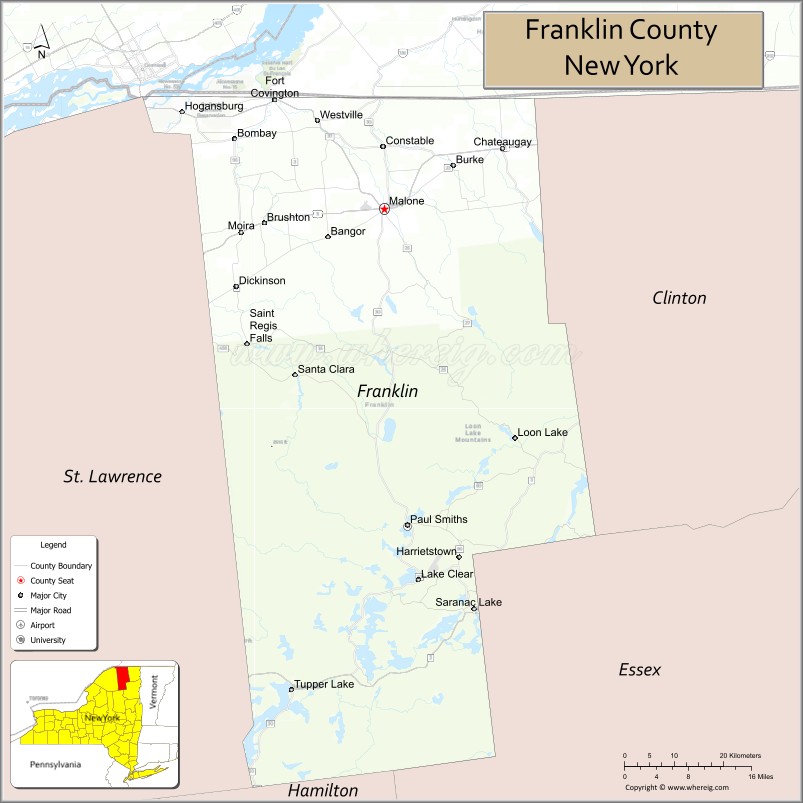
About Franklin County Map, New York: The map showing the county boundary, county seat, major cities, highways, water bodies and neighbouring counties.
Related NY Maps & Info
About Franklin County, New York
Franklin County is a county located in the U.S. state of New York. It's county seat is Malone. As per 2020 census, the population of Franklin County is 47456 people and population density is 27.96 square miles. According to the United States Census Bureau, the county has a total area of 1,697 sq mi (4,395 km2). Franklin County was established on 1808.
Facts about Franklin County, New York
| Country | United States |
| State | New York |
| Region | Northern New York / North Country (Adirondack Park) |
| County Seat | Malone |
| Founded | March 11, 1808 |
| Named For | Benjamin Franklin (Founding Father) |
| Coordinates | 44.80° N, 74.30° W |
| Total Area | 1,697 sq mi |
| Land Area | 1,629 sq mi |
| Water Area | 68 sq mi |
| Water % | 4.0% |
| Population (2020) | 47,555 |
| Estimated Population (2024) | 47,086 |
| Population Density | 29/sq mi |
| Largest Town | Malone |
| Other Communities | Saranac Lake (part), Tupper Lake (part), Chateaugay, Fort Covington, Burke |
| Main Industries | Tourism, Outdoor recreation, Healthcare, Services, Forestry |
| Major Highways | I‑87, NY‑3, NY‑30, U.S. 11 |
| Time Zone | Eastern Time (UTC−05:00) |
| Known For | Adirondack Mountains & Park, Lake Saranac region, St. Regis Mohawk Reservation |
| Website | https://www.franklincountyny.gov/ |
Top Attractions in Franklin County, New York
- Adirondack Wildlife Refuge – Native wildlife education center.
- Saranac Lake – Arts, dining, and lakeside views.
- Lake Titus – Fishing and boating lake.
- Paul Smith’s College VIC – Nature trails and exhibits.
- Adirondack Scenic Railroad (seasonal) – Scenic train rides.
- Robert Moses State Park – Riverfront park and dam views.
- Upper Saranac Lake – Paddling and recreation.
- Adirondack Health History Museum – Tuberculosis treatment history.
- Debar Mountain Wild Forest – Hiking and wilderness trails.
- St. Regis Falls – Waterfalls and village scenery.
- Malone Golf Club – Championship golf courses.
- Salmon River Falls – Scenic waterfall views.
Cities & Towns in Franklin County, New York
Malone, Saranac Lake (partly), Chateaugay, Tupper Lake, Brushton, Chateaugay, Fort Covington, St. Regis Falls, Dickinson, Bangor, Bellmont, Moira, Bombay, Malone Center, Santa Clara, Franklin Falls
- Albany County Map
- Allegany County Map
- Bronx County Map
- Broome County Map
- Cattaraugus County Map
- Cayuga County Map
- Chautauqua County Map
- Chemung County Map
- Chenango County Map
- Clinton County Map
- Columbia County Map
- Cortland County Map
- Delaware County Map
- Dutchess County Map
- Erie County Map
- Essex County Map
- Franklin County Map
- Fulton County Map
- Genesee County Map
- Greene County Map
- Hamilton County Map
- Herkimer County Map
- Jefferson County Map
- Kings County Map
- Lewis County Map
- Livingston County Map
- Madison County Map
- Monroe County Map
- Montgomery County Map
- Nassau County Map
- New York County Map
- Niagara County Map
- Oneida County Map
- Onondaga County Map
- Ontario County Map
- Orange County Map
- Orleans County Map
- Oswego County Map
- Otsego County Map
- Putnam County Map
- Queens County Map
- Rensselaer County Map
- Richmond County Map
- Rockland County Map
- St Lawrence County Map
- Saratoga County Map
- Schenectady County Map
- Schoharie County Map
- Schuyler County Map
- Seneca County Map
- Steuben County Map
- Suffolk County Map
- Sullivan County Map
- Tioga County Map
- Tompkins County Map
- Ulster County Map
- Warren County Map
- Washington County Map
- Wayne County Map
- Westchester County Map
- Wyoming County Map
- Yates County Map
- Alabama Counties
- Alaska boroughs
- Arizona Counties
- Arkansas Counties
- California County Map
- Colorado Counties
- Connecticut Counties
- Delaware Counties
- Florida County Map
- Georgia County Map
- Hawaii Counties
- Idaho Counties
- Illinois Counties
- Indiana Counties
- Iowa Counties
- Kansas Counties
- Kentucky Counties
- Louisiana Counties
- Maine Counties
- Maryland Counties
- Massachusetts Counties
- Michigan County Map
- Minnesota Counties
- Mississippi Counties
- Missouri Counties
- Montana Counties
- Nebraska Counties
- Nevada Counties
- New York Counties
- New Hampshire Counties
- New Jersey Counties
- New Mexico Counties
- North Carolina Counties
- North Dakota Counties
- Ohio County Map
- Oklahoma Counties
- Oregon Counties
- Pennsylvania Counties
- Rhode Island Counties
- South Carolina Counties
- South Dakota Counties
- Map of Tennessee
- Texas County Map
- Utah Counties
- Vermont Counties
- Virginia Counties
- Washington Counties
- West Virginia Counties
- Wisconsin Counties
- Wyoming Counties