Written and Fact-checked by Mukesh Kumar | Updated On: April 256 2026 | 15:50 ET
Map of Rensselaer County - Rensselaer County is a county located in the U.S. state of New York. Rensselaer County Map showing cities, highways, important places and water bodies. Get Where is Rensselaer County located in the map, major cities in Rensselaer county, population, areas, and places of interest.
Map of Rensselaer County, New York
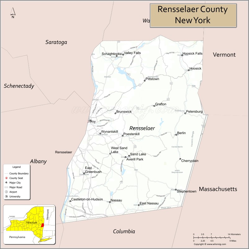
About Rensselaer County Map, New York: The map showing the county boundary, county seat, major cities, highways, water bodies and neighbouring counties.
Related NY Maps & Info
About Rensselaer County, New York
Rensselaer County is a county located in the U.S. state of New York. It's county seat is Troy. As per 2020 census, the population of Rensselaer County is 160232 people and population density is 240.95 square miles. According to the United States Census Bureau, the county has a total area of 665 sq mi (1,722 km2). Rensselaer County was established on 1791.
Facts about Rensselaer County, New York
| Country | United States |
| State | New York |
| Region | Capital District / Eastern New York |
| County Seat | Troy |
| Founded | 1791 |
| Named For | Family of Kiliaen van Rensselaer, Dutch patroon |
| Coordinates | 42.72° N, 73.82° W |
| Total Area | 665 sq mi (652 sq mi land, 13 sq mi water) |
| Water % | 1.9% |
| Population (2020) | 161,130 |
| Estimated Population (2023) | 160,341 |
| Population Density | 247/sq mi (land area) |
| Largest City | East Greenbush (largest by population) |
| Other Cities & Towns | Troy, Rensselaer, Brunswick, East Greenbush, North Greenbush, Sand Lake, Hoosick |
| Main Industries | Services, Education, Healthcare, Technology, Manufacturing |
| Major Highways | I‑90, U.S. 4, NY‑7 |
| Time Zone | Eastern Time (UTC−05:00) |
| Known For | Hudson River valley, historic Troy architecture, Rensselaer Polytechnic Institute (RPI), rural landscapes |
| Website | https://www.rensco.com/ |
Top Attractions in Rensselaer County, New York
- New York State Capitol (nearby) – Historic government building.
- Hudson River Waterfront – Scenic river views and parks.
- Rensselaer Polytechnic Institute Campus – Historic college grounds.
- Crailo State Historic Site – Dutch colonial history museum.
- Cherry Plain State Park – Lake, camping, and trails.
- Poestenkill Gorge Park – Waterfalls and hiking trails.
- Peebles Island State Park – River island nature park.
- Schodack Island State Park – Hudson River camping and trails.
- Troy Waterfront Farmers Market – Popular local market.
- Oakwood Cemetery – Historic hillside cemetery.
- Burden Iron Works Museum – Industrial history exhibits.
- Hoosic River – Fishing and paddling river.
Cities & Towns in Rensselaer County, New York
Troy, Rensselaer, East Greenbush, North Greenbush, Hoosick, Schodack, Nassau, Poestenkill, Pittstown, Brunswick, Sand Lake, Petersburgh, Berlin, Grafton, Poestenkill Center, Stephentown, Sand Lake Village
- Albany County Map
- Allegany County Map
- Bronx County Map
- Broome County Map
- Cattaraugus County Map
- Cayuga County Map
- Chautauqua County Map
- Chemung County Map
- Chenango County Map
- Clinton County Map
- Columbia County Map
- Cortland County Map
- Delaware County Map
- Dutchess County Map
- Erie County Map
- Essex County Map
- Franklin County Map
- Fulton County Map
- Genesee County Map
- Greene County Map
- Hamilton County Map
- Herkimer County Map
- Jefferson County Map
- Kings County Map
- Lewis County Map
- Livingston County Map
- Madison County Map
- Monroe County Map
- Montgomery County Map
- Nassau County Map
- New York County Map
- Niagara County Map
- Oneida County Map
- Onondaga County Map
- Ontario County Map
- Orange County Map
- Orleans County Map
- Oswego County Map
- Otsego County Map
- Putnam County Map
- Queens County Map
- Rensselaer County Map
- Richmond County Map
- Rockland County Map
- St Lawrence County Map
- Saratoga County Map
- Schenectady County Map
- Schoharie County Map
- Schuyler County Map
- Seneca County Map
- Steuben County Map
- Suffolk County Map
- Sullivan County Map
- Tioga County Map
- Tompkins County Map
- Ulster County Map
- Warren County Map
- Washington County Map
- Wayne County Map
- Westchester County Map
- Wyoming County Map
- Yates County Map
- Alabama Counties
- Alaska boroughs
- Arizona Counties
- Arkansas Counties
- California County Map
- Colorado Counties
- Connecticut Counties
- Delaware Counties
- Florida County Map
- Georgia County Map
- Hawaii Counties
- Idaho Counties
- Illinois Counties
- Indiana Counties
- Iowa Counties
- Kansas Counties
- Kentucky Counties
- Louisiana Counties
- Maine Counties
- Maryland Counties
- Massachusetts Counties
- Michigan County Map
- Minnesota Counties
- Mississippi Counties
- Missouri Counties
- Montana Counties
- Nebraska Counties
- Nevada Counties
- New York Counties
- New Hampshire Counties
- New Jersey Counties
- New Mexico Counties
- North Carolina Counties
- North Dakota Counties
- Ohio County Map
- Oklahoma Counties
- Oregon Counties
- Pennsylvania Counties
- Rhode Island Counties
- South Carolina Counties
- South Dakota Counties
- Map of Tennessee
- Texas County Map
- Utah Counties
- Vermont Counties
- Virginia Counties
- Washington Counties
- West Virginia Counties
- Wisconsin Counties
- Wyoming Counties