
Where is Freeport Located? - Freeport is a city located in the Armstrong County of New York, United States. Freeport lies between 40.826489 Degrees North latitudes and 74.1068091 Degrees West longitudes.
Location Map of Freeport, New York
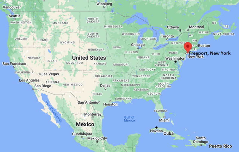
Freeport Map, New York, USA
Where is Freeport?: The Google Map showing the location of Freeport in the U.S. state of New York.
Where is Freeport Located?
Freeport is a city located in the Armstrong County of New York, United States. Freeport lies between 40.826489 Degrees North latitudes and 74.1068091 Degrees West longitudes. According to 2020 U.S.census, the population of Freeport city is 44472 people and the city has a total area of 4.58 sq mi. The city has numerous parks and recreational facilities.
Most Viewed US Maps
| USA Sttae Map | USA Region Map | USA Road Map |
| USA County Map | Where is USA in World Map? | US ZIP Code Map |
| USA Time Zones Map | US State and Capitals Map | USA Physical Map |
Find 4,400+ U.S. Cities by State - Explore Their Locations and Get Detailed Information
Freeport, New York Quick Facts
| Property | Information |
|---|---|
| City | Freeport (Incorporated Village) |
| County | Nassau County |
| State | New York |
| State Capital | Albany |
| US Region | Northeast |
| Latitude | 40.6576°N |
| Longitude | 73.5832°W |
| Elevation | 20 ft (6 m) |
| Land Area | 4.38 sq mi |
| Water Area | 2.42 sq mi |
| Total Area | 6.80 sq mi |
| Population (2020 Census) | 44,472 |
| Population Density | 10,154 per sq mi |
| ZIP Codes | 11520 |
| Area Code | 516 |
| Time Zone Standard | Eastern Standard Time (EST, UTC−5) |
| Time Zone Daylight | Eastern Daylight Time (EDT, UTC−4) |
| Currency | United States Dollar (USD) |
| FIPS Code | 36-27469 |
| Congressional District | New York's 4th Congressional District |
Nearby Cities to Freeport, New York
- Baldwin, New York - North - 2 mi
- Merrick, New York - East - 3 mi
- Roosevelt, New York - Northeast - 3 mi
- Rockville Centre, New York - Northwest - 4 mi
- Oceanside, New York - West - 5 mi
- East Meadow, New York - North - 7 mi
- Hempstead, New York - North - 7 mi
- Wantagh, New York - East - 8 mi
- Long Beach, New York - Southwest - 9 mi
- Queens, New York - West - 18 mi
Driving Distances from Freeport, New York
| City | State | Distance (mi) | Approx. Drive Time |
|---|---|---|---|
| Baldwin | New York | 2 | 7 minutes |
| Merrick | New York | 3 | 10 minutes |
| Roosevelt | New York | 3 | 10 minutes |
| Rockville Centre | New York | 4 | 12 minutes |
| Oceanside | New York | 5 | 15 minutes |
| East Meadow | New York | 7 | 18 minutes |
| Hempstead | New York | 7 | 18 minutes |
| Wantagh | New York | 8 | 20 minutes |
| Long Beach | New York | 9 | 20 minutes |
| Manhattan | New York | 31 | 55 minutes |
Transportation and Connectivity in Freeport, New York
| Mode | Details |
|---|---|
| Airport Name | John F. Kennedy International Airport |
| IATA Code | JFK |
| Port | Freeport Marina and Nautical Mile |
| Major Highways | Meadowbrook State Parkway, Southern State Parkway, Sunrise Highway (NY 27), Merrick Road |
| Train/Amtrak Service | Long Island Rail Road (Freeport Station); nearest Amtrak service at Penn Station, New York City |
| Local Bus/Transit Service | Nassau Inter-County Express (NICE Bus) |
- Meadowbrook State Parkway connects Freeport with the Northern State Parkway, Jones Beach, and Long Island Expressway.
- Southern State Parkway provides regional east-west travel across Long Island.
- Sunrise Highway (NY 27) is a major commuter route linking Freeport with western and eastern Long Island.
- Merrick Road serves as the village's principal commercial corridor, connecting neighboring South Shore communities.
What are top Places to Visit in Freeport, New York
| Landmark Name | Type |
|---|---|
| The Nautical Mile | Waterfront District |
| Freeport Recreation Center | Recreation Center |
| Cow Meadow Park Preserve | Nature Preserve |
| Sea Breeze Waterfront Park | Park |
| Freeport Memorial Library | Library |
| Jones Beach State Park | State Park |
| Norman J. Levy Park and Preserve | Nature Preserve |
| Marine Nature Study Area | Nature Center |
| Long Beach Boardwalk | Boardwalk |
| Cradle of Aviation Museum | Museum |
Colleges and Universities in Freeport, New York
| Institution Name | Type | Level | Notable For |
|---|---|---|---|
| Molloy University | Private | University | Nursing and health sciences |
| Hofstra University | Private | University | Business, law, and research programs |
| Nassau Community College | Public | Community College | Transfer and workforce education |
| Adelphi University | Private | University | Liberal arts and graduate studies |
| Freeport Union Free School District | Public | K–12 District | Public education serving the village |
Waterbodies in Freeport, New York
Hempstead Bay, South Oyster Bay, Freeport Creek, Woodcleft Canal, Hudson Canal, Baldwin Bay, East Bay, Atlantic Ocean
Golf Courses in Freeport, New York
Merrick Golf Course, Lido Golf Club, Middle Bay Country Club, Hempstead Golf and Country Club, Rockville Links Club, North Woodmere Golf Course
Freeport, New York — Key Historical Facts
- Freeport was settled during the seventeenth century and developed into an important South Shore fishing and oyster harvesting community.
- The arrival of the Long Island Rail Road in the nineteenth century transformed the village into a popular residential and resort destination.
- Freeport became incorporated as a village in 1892 and grew rapidly through boating, maritime commerce, and waterfront recreation.
- The Nautical Mile emerged as one of Long Island's best-known waterfront entertainment districts, featuring restaurants, marinas, and charter fishing boats.
- Today, Freeport is recognized for its maritime heritage, vibrant waterfront, recreational boating, and convenient commuter access to New York City.
References
New York Maps and Info
| New York Map | Counties in New York | Cities in New York |
| New York Zipcodes | Airports in New York | US Zip code Map |
| New York Area Codes | New York River Map | - |
- Where is Albany
- Where is Auburn
- Where is Baldwin
- Where is Bay Shore
- Where is Binghamton
- Where is Brentwood
- Where is Brighton
- Where is Centereach
- Where is Central Islip
- Where is Cheektowaga
- Where is Commack
- Where is Copiague
- Where is Coram
- Where is Deer Park
- Where is Dix Hills
- Where is East Massapequa
- Where is East Meadow
- Where is East Patchogue
- Where is Eastchester
- Where is Elmira
- Where is Elmont
- Where is Franklin Square
- Where is Freeport
- Where is Garden City
- Where is Glen Cove
- Where is Harrison
- Where is Hempstead
- Where is Hicksville
- Where is Holbrook
- Where is Huntington
- Where is Huntington Station
- Where is Irondequoit
- Where is Ithaca
- Where is Jamestown
- Where is Kingston
- Where is Kiryas Joel
- Where is Lackawanna
- Where is Levittown
- Where is Lindenhurst
- Where is Lockport
- Where is Lynbrook
- Where is Mamaroneck
- Where is Massapequa
- Where is Medford
- Where is Merrick
- Where is Middletown
- Where is Mineola
- Where is Monsey
- Where is Mount Vernon
- Where is New City
- Where is New Rochelle
- Where is Newburgh
- Where is Niagara Falls
- Where is North Bellmore
- Where is North Tonawanda
- Where is Oceanside
- Where is Ossining
- Where is Peekskill
- Where is Plainview
- Where is Port Chester
- Where is Poughkeepsie
- Where is Rockville Centre
- Where is Rome
- Where is Rotterdam
- Where is Saratoga Springs
- Where is Schenectady
- Where is Selden
- Where is Shirley
- Where is Smithtown
- Where is Spring Valley
- Where is Syracuse
- Where is Troy
- Where is Uniondale
- Where is Utica
- Where is Valley Stream
- Where is Watertown
- Where is West Babylon
- Where is West Hempstead
- Where is West Islip
- Where is West Seneca
- Where is White Plains
- Where is Yonkers