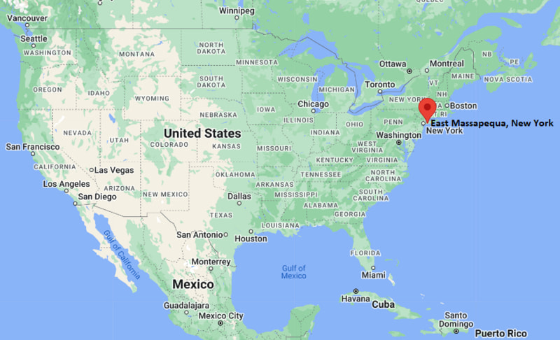
Where is East Massapequa Located? - East Massapequa is a city located in the Nassau County, New York County of New York, United States. East Massapequa lies between 39.9935959 Degrees North latitudes and 105.0897058 Degrees West longitudes.
Location Map of East Massapequa, New York
East Massapequa Map, New York, USA
Where is East Massapequa?: The Google Map showing the location of East Massapequa in the U.S. state of New York.
Where is East Massapequa Located?
East Massapequa is a city located in the Nassau County, New York County of New York, United States. East Massapequa lies between 39.9935959 Degrees North latitudes and 105.0897058 Degrees West longitudes. According to 2020 U.S.census, the population of East Massapequa city is 19854 people and the city has a total area of 3.42 sq mi. The city has numerous parks and recreational facilities.
East Massapequa, New York Climate and Weather Overview
Month
Avg High (°F)
Avg Low (°F)
Avg Rainfall (in)
January
40
26
3.5
April
60
42
4.2
July
84
69
4.2
October
65
49
4.1
Annual
63
47
49.8
Climate Attribute
Details
Climate Classification (Köppen)
Humid Subtropical (Cfa)
Annual Rainfall
Approximately 50 inches
Annual Sunshine Days
About 205 days
Hurricane/Tornado Risk
Moderate hurricane risk; low tornado risk
Snowfall
Approximately 24 inches annually
Driving Distances from East Massapequa, New York
City
State
Distance (mi)
Approx. Drive Time
Massapequa
New York
2
5 min
Massapequa Park
New York
3
8 min
Amityville
New York
4
10 min
Seaford
New York
4
10 min
Farmingdale
New York
6
15 min
Bethpage
New York
8
18 min
Hicksville
New York
11
22 min
Mineola
New York
18
30 min
Queens
New York
29
45 min
New York City
New York
36
55 min
Transportation and Connectivity in East Massapequa, New York
Transportation
Details
Airport Name
John F. Kennedy International Airport
IATA Code
JFK
Port
None; nearby access to South Oyster Bay and Great South Bay marinas
Major Highways
Sunrise Highway (NY 27), Southern State Parkway, Wantagh State Parkway
Train/Amtrak Service
Long Island Rail Road (Massapequa Station); nearest Amtrak at New York Penn Station
Local Bus/Transit Service
Nassau Inter-County Express (NICE Bus)
Sunrise Highway (NY 27) — Major east-west corridor serving Long Island communities.
Southern State Parkway — Connects East Massapequa with western and eastern Long Island.
Wantagh State Parkway — Provides direct access between inland Nassau County and Jones Beach State Park.
Merrick Road (NY 27A) — Local arterial connecting nearby South Shore communities.
Places to Visit in East Massapequa, New York
Landmark Name
Type
Massapequa Preserve
Nature Preserve
John J. Burns Park
County Park
Tobay Beach
Beach
Norman J. Levy Park and Preserve
Nature Park
Brady Park
Community Park
Marjorie R. Post Community Park
Waterfront Park
Jones Beach State Park
State Park
Tackapausha Museum and Preserve
Nature Museum
American Airpower Museum
Aviation Museum
Adventureland
Amusement Park
Colleges and Universities in East Massapequa, New York
Institution Name
Type
Level
Notable For
Farmingdale State College
Public
University
SUNY technology programs
Nassau Community College
Public
Community College
Associate degree programs
Molloy University
Private
University
Nursing and health sciences
Hofstra University
Private
University
Research and law programs
Adelphi University
Private
University
Liberal arts and healthcare
SUNY Old Westbury
Public
University
Public liberal arts education
Five Towns College
Private
University
Music and media arts
Plainedge Union Free School District
Public
K–12 District
Local public education
Waterbodies in East Massapequa, New York
Massapequa Creek, South Oyster Bay, Great South Bay, Massapequa Lake, Unqua Creek, Seaford Creek, West Amityville Creek, Jones Inlet
Golf Courses in East Massapequa, New York
Bethpage State Park Golf Courses, Merrick Golf Course, Peninsula Golf Club, Middle Bay Country Club, Colonial Springs Golf Club, Bergen Point Golf Course, Timber Point Golf Course, Heartland Golf Park
East Massapequa, New York — Key Historical Facts
East Massapequa developed rapidly after World War II as new residential neighborhoods expanded across Nassau County.
The community shares its heritage with the historic Massapequa area, named after the Massapequa people who originally inhabited this part of Long Island.
Improved transportation, including the Long Island Rail Road and nearby parkways, encouraged suburban growth throughout the 1950s and 1960s.
The area's proximity to South Oyster Bay helped shape its recreational traditions, including boating, fishing, and waterfront activities.
East Massapequa has remained primarily residential while benefiting from nearby shopping, parks, and employment centers across Long Island.
Today, the hamlet is known for its family-friendly neighborhoods, convenient transportation links, and easy access to Jones Beach State Park.