
Sedona is a city in the Verde Valley of northern Arizona, part of the Flagstaff metropolitan region and located across Yavapai and Coconino counties. About 30 miles southwest of Flagstaff, Sedona is surrounded by towering red-rock formations, Oak Creek, and desert forests. The city is known for Cathedral Rock, Oak Creek Canyon, scenic trails, and its long connection with the arts.
Location Map of Sedona, Yavapai County, Arizona
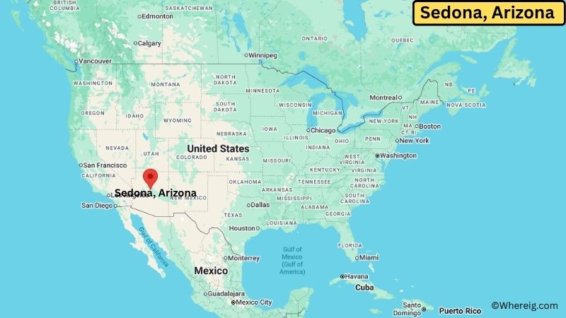
About Map: The map shows the location of Sedona in Yavapai County, in the U.S. state of Arizona.
Sedona Map, Arizona
About Sedona Map: The Google Map highlights the location of Sedona in Yavapai County, Arizona. Use the zoom, satellite, and street-view options to explore the city's neighborhoods, roads, and nearby places.
Where is Sedona Located?
Sedona is a city located in Yavapai County and Coconino County, Arizona, the United States. The city straddles the county line in northern Arizona, beneath the Mogollon Rim and along Oak Creek. Sedona is about 30 miles from Flagstaff, 30 miles from Cottonwood, and roughly 120 miles north of Phoenix. It is located at approximately 34.8688° North latitude and 111.7610° West longitude. The 2020 Census recorded 9,684 residents. The Census Bureau reported 18.26 square miles of land area in 2020, while the city describes its incorporated community as roughly 19 square miles. Cathedral Rock and the surrounding red-rock country are major landmarks. Sedona incorporated as a city in 1988. A unique feature is its location across two counties, with much of the surrounding landscape protected as national forest.
Most Viewed US Maps
| USA Sttae Map | USA Region Map | USA Road Map |
| USA County Map | Where is USA in World Map? | US ZIP Code Map |
| USA Time Zones Map | US State and Capitals Map | USA Physical Map |
Find 4,400+ U.S. Cities by State - Explore Their Locations and Get Detailed Information
Sedona City Facts
| Fact | Details |
|---|---|
| City | Sedona |
| State | Arizona |
| County | Yavapai County and Coconino County |
| Country | United States |
| Region | Verde Valley, Northern Arizona |
| Incorporated | 1988 |
| Founded | 1902 |
| Total Area | About 19 sq mi (49.2 sq km) |
| Land Area | 18.26 sq mi (47.29 sq km) in 2020 Census data |
| Water Area | About 0.08 sq mi (0.21 sq km) |
| Elevation | About 4,500 ft (1,372 m) |
| Population (2023 estimate) | About 9,700 |
| Population (2020 Census) | 9,684 |
| Population Density | 530.3 people per sq mi |
| Time Zone | Mountain Standard Time (MST) |
| ZIP Codes | 86336, 86340, 86341, 86351 |
| Area Code | 928 |
| Major Highways | Arizona State Route 89A, Arizona State Route 179, Schnebly Hill Road |
| Public Transit | Verde Lynx and Sedona Shuttle |
| Major Attractions | Cathedral Rock, Oak Creek Canyon, Red Rock State Park, Tlaquepaque Arts & Shopping Village |
| Official Website | https://www.sedonaaz.gov/ |
Distance from Sedona, AZ to Nearby Cities
- Cottonwood, AZ – 30 miles (48 km)
- Camp Verde, AZ – 28 miles (45 km)
- Flagstaff, AZ – 30 miles (48 km)
- Clarkdale, AZ – 27 miles (43 km)
- Jerome, AZ – 30 miles (48 km)
- Prescott, AZ – 55 miles (89 km)
- Prescott Valley, AZ – 50 miles (80 km)
- Williams, AZ – 60 miles (97 km)
- Payson, AZ – 80 miles (129 km)
- Winslow, AZ – 100 miles (161 km)
- Kingman, AZ – 145 miles (233 km)
- Phoenix, AZ – 120 miles (193 km)
- Mesa, AZ – 135 miles (217 km)
- Scottsdale, AZ – 130 miles (209 km)
- Tempe, AZ – 130 miles (209 km)
- Glendale, AZ – 125 miles (201 km)
- Page, AZ – 160 miles (257 km)
- Grand Canyon Village, AZ – 115 miles (185 km)
Top Attractions in Sedona, Arizona
- Cathedral Rock – One of Sedona’s most recognizable red-rock formations and a popular destination for hiking, photography, and scenic views.
- Oak Creek Canyon – A dramatic canyon north of Sedona with red cliffs, forests, Oak Creek, scenic drives, and hiking trails.
- Red Rock State Park – A nature preserve near Sedona featuring red-rock scenery, trails, Oak Creek, wildlife, and educational programs.
- Tlaquepaque Arts & Shopping Village – A distinctive arts and shopping district designed around courtyards, stone buildings, galleries, and local cultural spaces.
- Bell Rock – A prominent red-rock formation near the southern entrance to Sedona and a popular location for hiking and scenic views.
- Chapel of the Holy Cross – A well-known modern chapel built into the red rocks with views across the surrounding Sedona landscape.
- Slide Rock State Park – A popular Oak Creek recreation area north of Sedona known for its natural rock water slide, creek, and canyon scenery.
- Airport Mesa – A scenic overlook and hiking area offering broad views of Sedona’s red-rock formations and surrounding valleys.
- Palatki Heritage Site – A protected archaeological and rock-art site in the Coconino National Forest featuring ancient cliff dwellings and pictographs.
Airports Near Sedona, Arizona
- Flagstaff Pulliam Airport (FLG) – 25 miles
- Sedona Airport (SDX) – 3 miles
- Prescott Regional Airport (PRC) – 65 miles
- Phoenix Sky Harbor International Airport (PHX) – 125 miles
Sources:
Population and area data sourced from the United States Census Bureau (2020 Census). General city information referenced from the official Sedona city website and local government records.
Arizona Related Links
- Where is Anthem
- Where is Apache Junction
- Where is Avondale
- Where is Benson
- Where is Bullhead City
- Where is Casa Grande
- Where is Casas Adobes
- Where is Catalina Foothills
- Where is Douglas
- Where is Drexel Heights
- Where is El Mirage
- Where is Eloy
- Where is Flagstaff
- Where is Florence
- Where is Flowing Wells
- Where is Fort Mohave
- Where is Fortuna Foothills
- Where is Fountain Hills
- Where is Glendale
- Where is Globe
- Where is Goodyear
- Where is Green Valley
- Where is Guadalupe
- Where is Kingman
- Where is Lake Havasu City
- Where is Litchfield Park
- Where is Marana
- Where is Maricopa
- Where is New River
- Where is Nogales
- Where is Oro Valley
- Where is Page
- Where is Payson
- Where is Peoria
- Where is Prescott
- Where is Prescott Valley
- Where is Queen Creek
- Where is Rio Rico
- Where is Sahuarita
- Where is San Luis
- Where is San Tan Valley
- Where is Sierra Vista
- Where is Snowflake
- Where is Sun City
- Where is Sun City West
- Where is Sun Lakes
- Where is Surprise
- Where is Tanque Verde
- Where is Tempe
- Where is Thatcher
- Where is Tolleson
- Where is Valencia West
- Where is Wickenburg
- Where is Youngtown
- Where is Yuma