
Show Low is a city in the White Mountains of eastern Arizona and the county seat of Navajo County. Located about 175 miles northeast of Phoenix, the city sits at a high elevation among pine forests and mountain lakes. Show Low is known for its cool climate, outdoor recreation, nearby Fool Hollow Lake, and access to the Apache-Sitgreaves National Forest.
Location Map of Show Low, Navajo County, Arizona
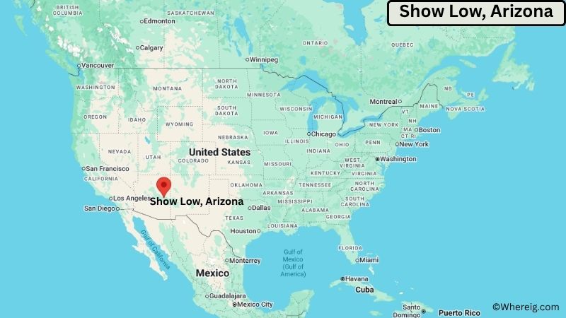
About Map: The map shows the location of Show Low in Navajo County, in the U.S. state of Arizona.
Show Low Map, Arizona
About Show Low Map: The Google Map highlights the location of Show Low in Navajo County, Arizona. Use the zoom, satellite, and street-view options to explore the city's neighborhoods, roads, and nearby places.
Where is Show Low Located?
Show Low is a city located in Navajo County, Arizona, the United States. It lies in the White Mountains of eastern Arizona at an elevation of more than 6,300 feet. Show Low is about 175 miles northeast of Phoenix, 160 miles east of Prescott, and roughly 50 miles south of Holbrook. The city is located at 34.2542° North latitude and 110.0298° West longitude. The 2020 Census recorded 11,732 residents. Show Low covers about 64.2 square miles (166.5 square kilometers), making it one of the larger incorporated communities in the region by area. The surrounding ponderosa pine forests, mountain lakes, and high-elevation terrain are major geographic features. Fool Hollow Lake Recreation Area is a popular attraction near the city. A unique fact about Show Low is that its unusual name is linked to an old story involving a game of cards, with the phrase "if you can show low, you win" associated with the community's naming.
Most Viewed US Maps
| USA Sttae Map | USA Region Map | USA Road Map |
| USA County Map | Where is USA in World Map? | US ZIP Code Map |
| USA Time Zones Map | US State and Capitals Map | USA Physical Map |
Find 4,400+ U.S. Cities by State - Explore Their Locations and Get Detailed Information
Show Low City Facts
| Fact | Details |
|---|---|
| City | Show Low |
| State | Arizona |
| County | Navajo County |
| Country | United States |
| Region | White Mountains, Eastern Arizona |
| Incorporated | 1953 |
| Founded | 1876 |
| Total Area | 64.2 sq mi (166.5 sq km) |
| Land Area | 63.9 sq mi (165.4 sq km) |
| Water Area | 0.3 sq mi (1.1 sq km) |
| Elevation | About 6,345 ft (1,934 m) |
| Population (2023 estimate) | About 12,000 |
| Population (2020 Census) | 11,732 |
| Population Density | About 184 people per sq mi |
| Time Zone | Mountain Standard Time (MST) |
| ZIP Codes | 85901, 85902, 85911 |
| Area Code | 928 |
| Major Highways | U.S. Highway 60, U.S. Highway 180, Arizona State Route 77 |
| Public Transit | Northern Arizona Intergovernmental Public Transportation services |
| Major Attractions | Fool Hollow Lake Recreation Area, Show Low Lake, Apache-Sitgreaves National Forest, Mogollon Rim |
| Official Website | https://www.showlowaz.gov/ |
Distance from Show Low, AZ to Nearby Cities
- Lakeside, AZ – 5 miles (8 km)
- Pinetop-Lakeside, AZ – 7 miles (11 km)
- Taylor, AZ – 30 miles (48 km)
- Snowflake, AZ – 35 miles (56 km)
- Heber-Overgaard, AZ – 45 miles (72 km)
- Holbrook, AZ – 50 miles (80 km)
- Springerville, AZ – 65 miles (105 km)
- St. Johns, AZ – 75 miles (121 km)
- Winslow, AZ – 75 miles (121 km)
- Globe, AZ – 100 miles (161 km)
- Payson, AZ – 105 miles (169 km)
- Prescott, AZ – 160 miles (257 km)
- Flagstaff, AZ – 160 miles (257 km)
- Phoenix, AZ – 175 miles (282 km)
- Mesa, AZ – 170 miles (274 km)
- Scottsdale, AZ – 180 miles (290 km)
- Tucson, AZ – 285 miles (459 km)
- Albuquerque, NM – 300 miles (483 km)
Top Attractions in Show Low, Arizona
- Fool Hollow Lake Recreation Area – A popular mountain recreation area near Show Low offering fishing, boating, camping, hiking, wildlife viewing, and scenic lake views.
- Show Low Lake – A high-elevation lake within the city offering fishing, boating, camping, walking trails, and picnic areas.
- Apache-Sitgreaves National Forests – A vast forest region surrounding Show Low with pine forests, mountain lakes, hiking trails, campgrounds, and wildlife habitat.
- Mogollon Rim – A dramatic geological escarpment north of Show Low offering expansive views, hiking opportunities, forests, and scenic drives.
- Show Low Historical Society Museum – A local museum preserving photographs, artifacts, documents, and stories from Show Low and the White Mountains.
- Unity of the White Mountains – A distinctive local landmark and community gathering place in the Show Low area.
- White Mountain Nature Center – A nearby educational nature center with exhibits and programs focused on the forests, wildlife, and ecology of the White Mountains.
- Sunrise Park Resort – A mountain recreation destination near Greer offering skiing and snowboarding in winter and hiking and other outdoor activities during warmer months.
- Woodland Lake Park – A nearby recreation area in Pinetop-Lakeside featuring a lake, walking trails, fishing, picnic areas, and forest scenery.
Airports Near Show Low, Arizona
- Show Low Regional Airport (SOW) – 3 miles
- Winslow-Lindbergh Regional Airport (INW) – 80 miles
- Flagstaff Pulliam Airport (FLG) – 160 miles
- Phoenix Sky Harbor International Airport (PHX) – 180 miles
Sources:
Population and area data sourced from the United States Census Bureau (2020 Census). General city information referenced from the official Show Low city website and local government records.
Arizona Related Links
- Where is Anthem
- Where is Apache Junction
- Where is Avondale
- Where is Benson
- Where is Bullhead City
- Where is Casa Grande
- Where is Casas Adobes
- Where is Catalina Foothills
- Where is Douglas
- Where is Drexel Heights
- Where is El Mirage
- Where is Eloy
- Where is Flagstaff
- Where is Florence
- Where is Flowing Wells
- Where is Fort Mohave
- Where is Fortuna Foothills
- Where is Fountain Hills
- Where is Glendale
- Where is Globe
- Where is Goodyear
- Where is Green Valley
- Where is Guadalupe
- Where is Kingman
- Where is Lake Havasu City
- Where is Litchfield Park
- Where is Marana
- Where is Maricopa
- Where is New River
- Where is Nogales
- Where is Oro Valley
- Where is Page
- Where is Payson
- Where is Peoria
- Where is Prescott
- Where is Prescott Valley
- Where is Queen Creek
- Where is Rio Rico
- Where is Sahuarita
- Where is San Luis
- Where is San Tan Valley
- Where is Sierra Vista
- Where is Snowflake
- Where is Sun City
- Where is Sun City West
- Where is Sun Lakes
- Where is Surprise
- Where is Tanque Verde
- Where is Tempe
- Where is Thatcher
- Where is Tolleson
- Where is Valencia West
- Where is Wickenburg
- Where is Youngtown
- Where is Yuma