Map of Jones County - Jones County is a county located in the U.S. state of Georgia. Jones County Map showing cities, highways, important places and water bodies. Get Where is Jones County located in the map, major cities in Jones county, population, areas, and places of interest.
Map of Jones County, Georgia
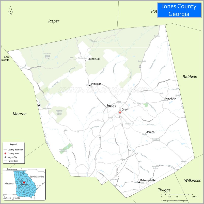
About Jones County Map, Georgia: The map showing the county boundary, county seat, major cities, highways, water bodies and neighbouring counties.
Most Viewed Links
Map of Jones County, Georgia
Jones County is a county located in the U.S. state of Georgia. It's county seat is Gray. As per 2020 census, the population of Jones County is 28400 people and population density is 72.08 square miles. According to the United States Census Bureau, the county has a total area of 394 sq mi (1,020 km2). Jones County was established on 1807.
Facts about Jones County, Georgia
| Country | United States |
| State | Georgia |
| Region | Central Georgia (Piedmont / near Macon metro area) |
| County Seat | Gray |
| Named For | James Jones (U.S. Representative) |
| Established | December 10, 1807 |
| Coordinates | ~33.06° N, 83.56° W |
| Total Area | ~395 sq mi |
| Land Area | ~394 sq mi |
| Water Area | ~1.5 sq mi (≈0.4%) |
| Population (2020) | 28,347 |
| Estimated Population (2024) | ~29,047 |
| Estimated Population (2025) | ~29,094 |
| Population Rank | Mid-sized county in Georgia |
| Largest City | Gray |
| Main Industries | Agriculture, Services, Retail, Local Business |
| Major Airport | Nearest major airport: Hartsfield–Jackson Atlanta International Airport |
| Time Zone | Eastern Time (UTC−05:00) |
| Known For | Historic Gray & Jones County Courthouse, Lake Tobesofkee, rural-urban mix near Macon |
| Website | https://www.jonescountyga.org/ |
Ctities in Jones county
| City Name | Type | Population (2020) | Pop. Density | Area |
|---|---|---|---|---|
| Gray | City | 3,436 | 885.6/sq mi (341.9/km2) | 3.88 sq mi (10 km2) |
Places to Visit in Jones
Top places to visit in london includes Jarrell Plantation State Historic Site, Piedmont National Wildlife, Oconee National Forest.
Highways in Jones
U.S. Route 129, State Route 11, State Route 18, State Route 22, State Route 44, State Route 49, State Route 57, State Route 540.
- Appling County Map
- Atkinson County Map
- Bacon County Map
- Baker County Map
- Baldwin County Map
- Banks County Map
- Barrow County Map
- Bartow County Map
- Ben Hill County Map
- Berrien County Map
- Bibb County Map
- Bleckley County Map
- Brantley County Map
- Brooks County Map
- Bryan County Map
- Bulloch County Map
- Burke County Map
- Butts County Map
- Calhoun County Map
- Camden County Map
- Candler County Map
- Carroll County Map
- Catoosa County Map
- Charlton County Map
- Chatham County Map
- Chattahoochee County Map
- Chattooga County Map
- Cherokee County Map
- Clarke County Map
- Clay County Map
- Clayton County Map
- Clinch County Map
- Cobb County Map
- Coffee County Map
- Colquitt County Map
- Columbia County Map
- Cook County Map
- Coweta County Map
- Crawford County Map
- Crisp County Map
- Dade County Map
- Dawson County Map
- Decatur County Map
- DeKalb County Map
- Dodge County Map
- Dooly County Map
- Dougherty County Map
- Douglas County Map
- Early County Map
- Echols County Map
- Effingham County Map
- Elbert County Map
- Emanuel County Map
- Evans County Map
- Fannin County Map
- Fayette County Map
- Floyd County Map
- Forsyth County Map
- Franklin County Map
- Fulton County Map
- Gilmer County Map
- Glascock County Map
- Glynn County Map
- Gordon County Map
- Grady County Map
- Greene County Map
- Gwinnett County Map
- Habersham County Map
- Hall County Map
- Hancock County Map
- Haralson County Map
- Harris County Map
- Hart County Map
- Heard County Map
- Henry County Map
- Houston County Map
- Irwin County Map
- Jackson County Map
- Jasper County Map
- Jeff Davis County Map
- Jefferson County Map
- Jenkins County Map
- Johnson County Map
- Jones County Map
- Lamar County Map
- Lanier County Map
- Laurens County Map
- Lee County Map
- Liberty County Map
- Lincoln County Map
- Long County Map
- Lowndes County Map
- Lumpkin County Map
- McDuffie County Map
- McIntosh County Map
- Macon County Map
- Madison County Map
- Marion County Map
- Meriwether County Map
- Miller County Map
- Mitchell County Map
- Monroe County Map
- Montgomery County Map
- Morgan County Map
- Murray County Map
- Muscogee County Map
- Newton County Map
- Oconee County Map
- Oglethorpe County Map
- Paulding County Map
- Peach County Map
- Pickens County Map
- Pierce County Map
- Pike County Map
- Polk County Map
- Pulaski County Map
- Putnam County Map
- Quitman County Map
- Rabun County Map
- Randolph County Map
- Richmond County Map
- Rockdale County Map
- Schley County Map
- Screven County Map
- Seminole County Map
- Spalding County Map
- Stephens County Map
- Stewart County Map
- Sumter County Map
- Talbot County Map
- Taliaferro County Map
- Tattnall County Map
- Taylor County Map
- Telfair County Map
- Terrell County Map
- Thomas County Map
- Tift County Map
- Toombs County Map
- Towns County Map
- Treutlen County Map
- Troup County Map
- Turner County Map
- Twiggs County Map
- Union County Map
- Upson County Map
- Walker County Map
- Walton County Map
- Ware County Map
- Warren County Map
- Washington County Map
- Wayne County Map
- Webster County Map
- Wheeler County Map
- White County Map
- Whitfield County Map
- Wilcox County Map
- Wilkes County Map
- Wilkinson County Map
- Worth County Map
- Alabama Counties
- Alaska boroughs
- Arizona Counties
- Arkansas Counties
- California County Map
- Colorado Counties
- Connecticut Counties
- Delaware Counties
- Florida County Map
- Georgia County Map
- Hawaii Counties
- Idaho Counties
- Illinois Counties
- Indiana Counties
- Iowa Counties
- Kansas Counties
- Kentucky Counties
- Louisiana Counties
- Maine Counties
- Maryland Counties
- Massachusetts Counties
- Michigan County Map
- Minnesota Counties
- Mississippi Counties
- Missouri Counties
- Montana Counties
- Nebraska Counties
- Nevada Counties
- New York Counties
- New Hampshire Counties
- New Jersey Counties
- New Mexico Counties
- North Carolina Counties
- North Dakota Counties
- Ohio County Map
- Oklahoma Counties
- Oregon Counties
- Pennsylvania Counties
- Rhode Island Counties
- South Carolina Counties
- South Dakota Counties
- Map of Tennessee
- Texas County Map
- Utah Counties
- Vermont Counties
- Virginia Counties
- Washington Counties
- West Virginia Counties
- Wisconsin Counties
- Wyoming Counties