Map of Meriwether County - Meriwether County is a county located in the U.S. state of Georgia. Meriwether County Map showing cities, highways, important places and water bodies. Get Where is Meriwether County located in the map, major cities in Meriwether county, population, areas, and places of interest.
Map of Meriwether County, Georgia
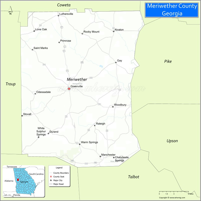
About Meriwether County Map, Georgia: The map showing the county boundary, county seat, major cities, highways, water bodies and neighbouring counties.
Most Viewed Links
Map of Meriwether County, Georgia
Meriwether County is a county located in the U.S. state of Georgia. It's county seat is Greenville. As per 2020 census, the population of Meriwether County is 20793 people and population density is 41.34 square miles. According to the United States Census Bureau, the county has a total area of 503 sq mi (1,303 km2). Meriwether County was established on 1827.
Facts about Meriwether County, Georgia
| Country | United States |
| State | Georgia |
| Region | West Central Georgia |
| County Seat | Greenville |
| Named After | Meriwether Lewis |
| Established | 1827 |
| Organized | 1827 |
| Coordinates | ~33.03° N, 84.68° W |
| Total Area | ~503 sq mi |
| Land Area | ~501 sq mi |
| Water Area | ~2 sq mi |
| Population (2020) | ~21,191 |
| Population Rank | Small to mid-sized county in Georgia |
| Major City | Greenville |
| Main Industries | Agriculture, Manufacturing, Tourism, Local Services |
| Major Airport | Nearest: Hartsfield–Jackson Atlanta International Airport |
| Time Zone | Eastern Time (UTC−05:00) |
| Known For | Warm Springs, Roosevelt State Park, Scenic Rural Landscapes |
| Website | https://www.meriwethercountyga.gov |
Ctities in Meriwether county
| City Name | Type | Population (2020) | Pop. Density | Area |
|---|---|---|---|---|
| Haralson | Town | 172 | 215.0/sq mi (83.0/km2) | 0.8 sq mi (2.1 km2) |
| Pine Mountain | Town | 1,216 | 422.2/sq mi (163.0/km2) | 2.88 sq mi (7.5 km2) |
| Gay | Town | 110 | 127.9/sq mi (49.4/km2) | 0.86 sq mi (2.2 km2) |
| Greenville | City | 794 | 339.3/sq mi (131.0/km2) | 2.34 sq mi (6.1 km2) |
| Lone Oak | Town | 114 | 183.9/sq mi (71.0/km2) | 0.62 sq mi (1.6 km2) |
| Luthersville | City | 776 | 245.6/sq mi (94.8/km2) | 3.16 sq mi (8.2 km2) |
| Warm Springs | City | 465 | 344.4/sq mi (133.0/km2) | 1.35 sq mi (3.5 km2) |
| Woodbury | City | 908 | 447.3/sq mi (172.7/km2) | 2.03 sq mi (5.3 km2) |
| Manchester | City | 3,584 | 447.4/sq mi (172.8/km2) | 8.01 sq mi (20.7 km2) |
Places to Visit in Meriwether
Top places to visit in london includes Red Oak Creek Covered Bridge, Georgia Aquarium, Joe Kurz Wildlife Management, Bogle Farm, F.D. Roosevelt State Park, Centennial Olympic Park, Wild Animal Safari - Pine, World of Coca-Cola, Mountain Top Inn & Resort.
Highways in Meriwether
Interstate 85, U.S. Route 27 , State Route 18, State Route 41, State Route 54, State Route 54, State Route 74, State Route 85 , State Route 85, State Route 100, State Route 109, State Route 109, State Route 173, State Route 190, State Route 194, State Route 362, State Route 403.
Nearest Airports
Nearest airport of Meriwether is Hartsfield-Jackson Atlanta International Airport.
- Appling County Map
- Atkinson County Map
- Bacon County Map
- Baker County Map
- Baldwin County Map
- Banks County Map
- Barrow County Map
- Bartow County Map
- Ben Hill County Map
- Berrien County Map
- Bibb County Map
- Bleckley County Map
- Brantley County Map
- Brooks County Map
- Bryan County Map
- Bulloch County Map
- Burke County Map
- Butts County Map
- Calhoun County Map
- Camden County Map
- Candler County Map
- Carroll County Map
- Catoosa County Map
- Charlton County Map
- Chatham County Map
- Chattahoochee County Map
- Chattooga County Map
- Cherokee County Map
- Clarke County Map
- Clay County Map
- Clayton County Map
- Clinch County Map
- Cobb County Map
- Coffee County Map
- Colquitt County Map
- Columbia County Map
- Cook County Map
- Coweta County Map
- Crawford County Map
- Crisp County Map
- Dade County Map
- Dawson County Map
- Decatur County Map
- DeKalb County Map
- Dodge County Map
- Dooly County Map
- Dougherty County Map
- Douglas County Map
- Early County Map
- Echols County Map
- Effingham County Map
- Elbert County Map
- Emanuel County Map
- Evans County Map
- Fannin County Map
- Fayette County Map
- Floyd County Map
- Forsyth County Map
- Franklin County Map
- Fulton County Map
- Gilmer County Map
- Glascock County Map
- Glynn County Map
- Gordon County Map
- Grady County Map
- Greene County Map
- Gwinnett County Map
- Habersham County Map
- Hall County Map
- Hancock County Map
- Haralson County Map
- Harris County Map
- Hart County Map
- Heard County Map
- Henry County Map
- Houston County Map
- Irwin County Map
- Jackson County Map
- Jasper County Map
- Jeff Davis County Map
- Jefferson County Map
- Jenkins County Map
- Johnson County Map
- Jones County Map
- Lamar County Map
- Lanier County Map
- Laurens County Map
- Lee County Map
- Liberty County Map
- Lincoln County Map
- Long County Map
- Lowndes County Map
- Lumpkin County Map
- McDuffie County Map
- McIntosh County Map
- Macon County Map
- Madison County Map
- Marion County Map
- Meriwether County Map
- Miller County Map
- Mitchell County Map
- Monroe County Map
- Montgomery County Map
- Morgan County Map
- Murray County Map
- Muscogee County Map
- Newton County Map
- Oconee County Map
- Oglethorpe County Map
- Paulding County Map
- Peach County Map
- Pickens County Map
- Pierce County Map
- Pike County Map
- Polk County Map
- Pulaski County Map
- Putnam County Map
- Quitman County Map
- Rabun County Map
- Randolph County Map
- Richmond County Map
- Rockdale County Map
- Schley County Map
- Screven County Map
- Seminole County Map
- Spalding County Map
- Stephens County Map
- Stewart County Map
- Sumter County Map
- Talbot County Map
- Taliaferro County Map
- Tattnall County Map
- Taylor County Map
- Telfair County Map
- Terrell County Map
- Thomas County Map
- Tift County Map
- Toombs County Map
- Towns County Map
- Treutlen County Map
- Troup County Map
- Turner County Map
- Twiggs County Map
- Union County Map
- Upson County Map
- Walker County Map
- Walton County Map
- Ware County Map
- Warren County Map
- Washington County Map
- Wayne County Map
- Webster County Map
- Wheeler County Map
- White County Map
- Whitfield County Map
- Wilcox County Map
- Wilkes County Map
- Wilkinson County Map
- Worth County Map
- Alabama Counties
- Alaska boroughs
- Arizona Counties
- Arkansas Counties
- California County Map
- Colorado Counties
- Connecticut Counties
- Delaware Counties
- Florida County Map
- Georgia County Map
- Hawaii Counties
- Idaho Counties
- Illinois Counties
- Indiana Counties
- Iowa Counties
- Kansas Counties
- Kentucky Counties
- Louisiana Counties
- Maine Counties
- Maryland Counties
- Massachusetts Counties
- Michigan County Map
- Minnesota Counties
- Mississippi Counties
- Missouri Counties
- Montana Counties
- Nebraska Counties
- Nevada Counties
- New York Counties
- New Hampshire Counties
- New Jersey Counties
- New Mexico Counties
- North Carolina Counties
- North Dakota Counties
- Ohio County Map
- Oklahoma Counties
- Oregon Counties
- Pennsylvania Counties
- Rhode Island Counties
- South Carolina Counties
- South Dakota Counties
- Map of Tennessee
- Texas County Map
- Utah Counties
- Vermont Counties
- Virginia Counties
- Washington Counties
- West Virginia Counties
- Wisconsin Counties
- Wyoming Counties