Written and Fact-checked by Whereig Editors, Reviewed by Mukesh Kumar| Last Updated On: May 11, 2026
Map of Montgomery County - Montgomery County is a county located in the U.S. state of Maryland. Montgomery County Map showing cities, highways, important places and water bodies. Get Where is Montgomery County located in the map, major cities in Montgomery county, population, areas, and places of interest.
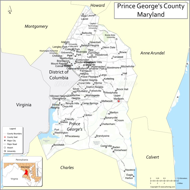
Map of Prince George's County, Maryland
About Montgomery County Map, Alabama: The map showing the county boundary, county seat, major cities, highways, water bodies and neighbouring counties.
More Maryland Maps & Info
Map of Prince George's County, Maryland
Prince George's County is a county located in the U.S. state of Maryland. It's county seat is Upper Marlboro. As per 2020 census, the population of Prince George's County is 955306 people and population density is square miles. According to the United States Census Bureau, the county has a total area of 498 sq mi (1,290 km2). Prince George's County was established on 1696.
Prince George's County Facts
| Continent | North America |
| Country | United States |
| State | Maryland |
| County Seat | Upper Marlboro |
| Largest City/Town | Bowie |
| Established | 1696 |
| Total Area | 499 sq mi (1,292 sq km) |
| Land Area | 483 sq mi (1,251 sq km) |
| Water Area | 16 sq mi (41 sq km) |
| Population | 967,201 (Census 2020) |
| Population Density | 2,002 people per sq mi |
| Time Zone | Eastern Time Zone (ET) |
| Major Highways | Interstate 95, Interstate 495, U.S. Route 50, Maryland Route 210 |
| Major Rivers | Potomac River, Patuxent River, Anacostia River |
| Neighboring Counties | Montgomery County, Howard County, Anne Arundel County, Charles County, Fairfax County (Virginia), Washington, D.C. |
| Famous For | Washington D.C. suburbs, University of Maryland, cultural diversity, sports venues, government and business centers |
| Top Attractions | National Harbor, Six Flags America, University of Maryland, FedExField, Watkins Regional Park |
| Official Website | Official Website |
About Prince George's County, Maryland
Prince George's County is located in central Maryland in the United States bordering Washington, D.C., and was established in 1696. The county seat is Upper Marlboro, while Bowie is the largest city by population. The county is known for diverse suburban communities, major transportation corridors, educational institutions, entertainment venues, and its close economic connection to the nation’s capital.
Cities and Communities in Prince George's County, Maryland
| City/Community | Population (Census 2020) | Latitude & Longitude |
|---|---|---|
| Bowie | 58,329 | 39.0068°N, 76.7791°W |
| Upper Marlboro (county seat) | 652 | 38.8151°N, 76.7497°W |
| College Park | 34,740 | 38.9897°N, 76.9378°W |
| Greenbelt | 24,921 | 39.0046°N, 76.8755°W |
| Laurel (partly) | 30,060 | 39.0993°N, 76.8483°W |
| Hyattsville | 21,187 | 38.9559°N, 76.9455°W |
| New Carrollton | 13,459 | 38.9687°N, 76.8769°W |
| Suitland | 25,825 | 38.8451°N, 76.9239°W |
| Oxon Hill | 17,722 | 38.8032°N, 76.9897°W |
| Capitol Heights | 4,050 | 38.8851°N, 76.9130°W |
Golf Courses in Prince George's County, Maryland
| Golf Course | Location | Latitude & Longitude |
|---|---|---|
| Lake Presidential Golf Club | Upper Marlboro | 38.7654°N, 76.7683°W |
| Enterprise Golf Course | Mitchellville | 38.9398°N, 76.7975°W |
| Oak Creek Golf Club | Upper Marlboro | 38.8441°N, 76.7870°W |
Roads and Highways in Prince George's County
Major highways connect the county with Washington, D.C., Baltimore, and surrounding Mid-Atlantic regions.
- Interstate 95 - major East Coast interstate passing through central Prince George's County
- Interstate 495 - Capital Beltway serving Washington metropolitan communities
- U.S. Route 50 - major highway linking Washington, D.C., Annapolis, and the Eastern Shore
- Maryland Route 210 - important commuter route connecting southern suburbs with Washington, D.C.
- Baltimore-Washington Parkway (MD 295) - major corridor between Baltimore and Washington
Neighboring Counties of Prince George's County
- Montgomery County (northwest)
- Howard County (north)
- Anne Arundel County (east)
- Charles County (south)
- Fairfax County, Virginia (southwest)
- Washington, D.C. (west)
Top Attractions in Prince George's County, Maryland
The county offers entertainment venues, parks, museums, and cultural attractions near the nation’s capital.
- National Harbor - waterfront entertainment district with hotels, restaurants, shopping, and ferris wheel
- Six Flags America - amusement park with roller coasters and water attractions
- University of Maryland - major public university with museums, sports, and cultural programs
- FedExField - professional football stadium and event venue
- Watkins Regional Park - miniature train, playgrounds, nature center, and recreation areas
- Greenbelt Park - forested national park area with hiking and camping near Washington, D.C.
- College Park Aviation Museum - exhibits on aviation history and early flight
- NASA Goddard Space Flight Center Visitor Center - space science exhibits and educational programs
- Bladensburg Waterfront Park - kayaking, trails, and Anacostia River recreation
- MGM National Harbor - casino resort, entertainment, dining, and live performances
Distance from Prince George's County to Nearby Cities
The following distances are measured by road (driving).
- Upper Marlboro to Washington, D.C. - 18 mi (29 km)
- Upper Marlboro to Annapolis (Anne Arundel County), Maryland - 27 mi (43 km)
- Upper Marlboro to Baltimore (Baltimore City), Maryland - 38 mi (61 km)
- Upper Marlboro to Frederick (Frederick County), Maryland - 58 mi (93 km)
- Upper Marlboro to Richmond (Richmond City), Virginia - 107 mi (172 km)
- Upper Marlboro to Philadelphia (Philadelphia County), Pennsylvania - 142 mi (229 km)
- Upper Marlboro to Norfolk (Norfolk City), Virginia - 199 mi (320 km)
- Upper Marlboro to Pittsburgh (Allegheny County), Pennsylvania - 254 mi (409 km)
- Upper Marlboro to New York City (New York County), New York - 226 mi (364 km)
- Upper Marlboro to Charlotte (Mecklenburg County), North Carolina - 398 mi (641 km)
- Upper Marlboro to Boston (Suffolk County), Massachusetts - 438 mi (705 km)
- Upper Marlboro to Cleveland (Cuyahoga County), Ohio - 401 mi (645 km)
FAQs about Prince George's County
Prince George's County is located in central Maryland bordering Washington, D.C.
Prince George's County has a population of 967,201 according to the Census 2020.
The county is known for diverse suburban communities, the University of Maryland, sports venues, and National Harbor.
Major highways include Interstate 95, Interstate 495, U.S. Route 50, and Maryland Route 210.
Yes, Prince George's County has golf facilities including Lake Presidential Golf Club and Oak Creek Golf Club.
References
- QuickFacts - U.S. Census Bureau
- United States Census Bureau
- United States Geological Survey (USGS)
- National Geodetic Survey
- Official Website
- Allegany County Map
- Anne Arundel County Map
- Baltimore County Map
- Calvert County Map
- Caroline County Map
- Carroll County Map
- Cecil County Map
- Charles County Map
- Dorchester County Map
- Frederick County Map
- Garrett County Map
- Harford County Map
- Howard County Map
- Kent County Map
- Montgomery County Map
- Prince George's County Map
- Queen Anne's County Map
- St Mary's County Map
- Somerset County Map
- Talbot County Map
- Washington County Map
- Wicomico County Map
- Worcester County Map
- Baltimore City County Map
- Alabama Counties
- Alaska boroughs
- Arizona Counties
- Arkansas Counties
- California County Map
- Colorado Counties
- Connecticut Counties
- Delaware Counties
- Florida County Map
- Georgia County Map
- Hawaii Counties
- Idaho Counties
- Illinois Counties
- Indiana Counties
- Iowa Counties
- Kansas Counties
- Kentucky Counties
- Louisiana Counties
- Maine Counties
- Maryland Counties
- Massachusetts Counties
- Michigan County Map
- Minnesota Counties
- Mississippi Counties
- Missouri Counties
- Montana Counties
- Nebraska Counties
- Nevada Counties
- New York Counties
- New Hampshire Counties
- New Jersey Counties
- New Mexico Counties
- North Carolina Counties
- North Dakota Counties
- Ohio County Map
- Oklahoma Counties
- Oregon Counties
- Pennsylvania Counties
- Rhode Island Counties
- South Carolina Counties
- South Dakota Counties
- Map of Tennessee
- Texas County Map
- Utah Counties
- Vermont Counties
- Virginia Counties
- Washington Counties
- West Virginia Counties
- Wisconsin Counties
- Wyoming Counties