Written and Fact-checked by Whereig Editors, Reviewed by Mukesh Kumar| Last Updated On: May 11, 2026
Map of Prince George's County - Prince George's County is a county located in the U.S. state of Maryland. Prince George's County Map showing cities, highways, important places and water bodies. Get Where is Prince George's County located in the map, major cities in Prince George's county, population, areas, and places of interest.
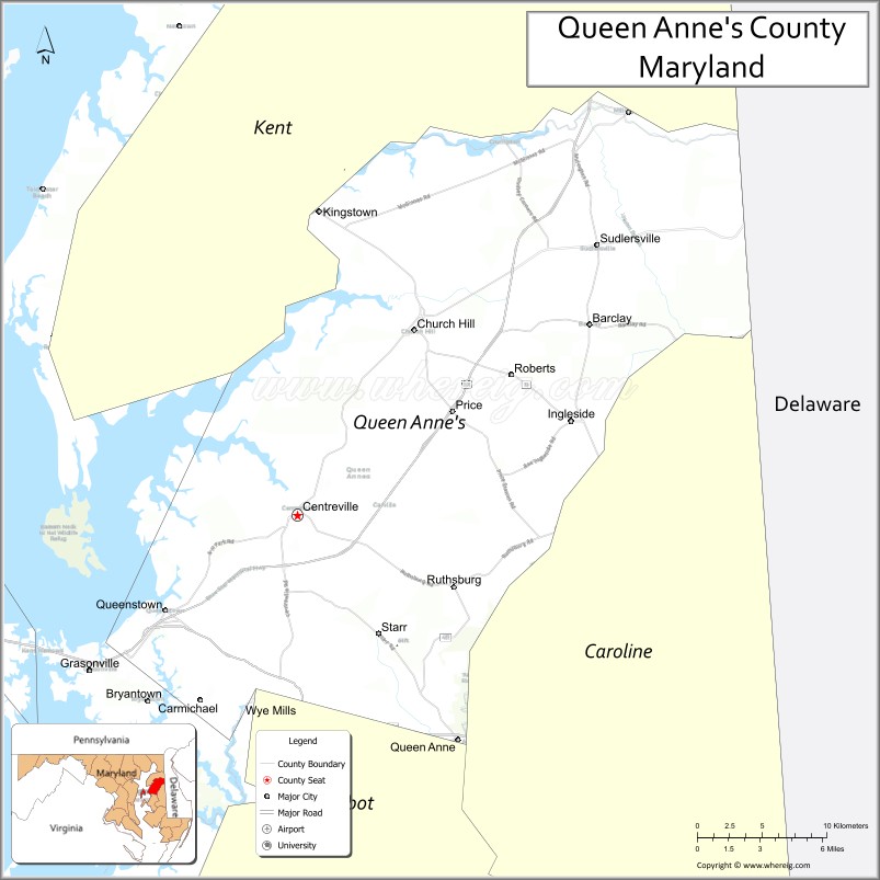
Map of Queen Anne's County, Maryland
About Prince George's County Map, Alabama: The map showing the county boundary, county seat, major cities, highways, water bodies and neighbouring counties.
More Maryland Maps & Info
Map of Queen Anne's County, Maryland
Queen Anne's County is a county located in the U.S. state of Maryland. It's county seat is Centreville. As per 2020 census, the population of Queen Anne's County is 50798 people and population density is square miles. According to the United States Census Bureau, the county has a total area of 510 sq mi (1,321 km2). Queen Anne's County was established on 1706.
Queen Anne's County Facts
| Continent | North America |
| Country | United States |
| State | Maryland |
| County Seat | Centreville |
| Largest City/Town | Stevensville |
| Established | 1706 |
| Total Area | 511 sq mi (1,323 sq km) |
| Land Area | 372 sq mi (964 sq km) |
| Water Area | 139 sq mi (360 sq km) |
| Population | 49,874 (Census 2020) |
| Population Density | 134 people per sq mi |
| Time Zone | Eastern Time Zone (ET) |
| Major Highways | U.S. Route 50, U.S. Route 301, Maryland Route 18, Maryland Route 213 |
| Major Rivers | Chester River, Wye River, Chesapeake Bay |
| Neighboring Counties | Kent County, Caroline County, Talbot County, Anne Arundel County |
| Famous For | Chesapeake Bay waterfronts, Kent Island, boating, seafood, scenic Eastern Shore communities |
| Top Attractions | Kent Island, Chesapeake Bay Bridge views, Terrapin Nature Park, Wye Island Natural Resources Management Area, Historic Centreville |
| Official Website | Official Website |
About Queen Anne's County, Maryland
Queen Anne's County is located on Maryland’s Eastern Shore in the United States along the Chesapeake Bay and was established in 1706. The county seat is Centreville, while Stevensville on Kent Island is the largest community. The county is known for waterfront living, boating, seafood, scenic bay landscapes, and easy access to the Chesapeake Bay Bridge.
Cities and Towns in Queen Anne's County, Maryland
| City/Town | Population (Census 2020) | Latitude & Longitude |
|---|---|---|
| Centreville (county seat) | 4,568 | 39.0412°N, 76.0663°W |
| Stevensville | 7,442 | 38.9807°N, 76.3144°W |
| Chester | 5,351 | 38.9779°N, 76.2894°W |
| Queenstown | 664 | 38.9918°N, 76.1608°W |
| Church Hill | 745 | 39.1440°N, 75.9924°W |
| Sudlersville | 497 | 39.1837°N, 75.8527°W |
| Millington (partly) | 642 | 39.2587°N, 75.8388°W |
| Grasonville | 3,425 | 38.9587°N, 76.2044°W |
| Barclay | 114 | 39.1396°N, 75.8616°W |
| Templeville (partly) | 128 | 39.1328°N, 75.8524°W |
Golf Courses in Queen Anne's County, Maryland
| Golf Course | Location | Latitude & Longitude |
|---|---|---|
| Queenstown Harbor Golf Links | Queenstown | 38.9767°N, 76.1512°W |
| Blue Heron Golf Course | Stevensville | 38.9948°N, 76.3304°W |
| Prospect Bay Country Club | Grasonville | 38.9505°N, 76.2108°W |
Roads and Highways in Queen Anne's County
Major highways connect the county with Annapolis, the Eastern Shore, and Delaware.
- U.S. Route 50 - major east-west highway crossing the Chesapeake Bay Bridge
- U.S. Route 301 - important regional corridor linking Maryland and Delaware
- Maryland Route 18 - scenic roadway serving Kent Island waterfront communities
- Maryland Route 213 - north-south route through Centreville and rural Eastern Shore areas
- Maryland Route 404 nearby - regional connector toward Delaware and Ocean City
Neighboring Counties of Queen Anne's County
- Kent County (north)
- Caroline County (east)
- Talbot County (south)
- Anne Arundel County (west across the Chesapeake Bay)
Top Attractions in Queen Anne's County, Maryland
The county offers Chesapeake Bay recreation, waterfront communities, and scenic Eastern Shore attractions.
- Kent Island - waterfront destination known for marinas, seafood restaurants, and bay views
- Chesapeake Bay Bridge Views - scenic observation points and photography locations
- Terrapin Nature Park - walking trails, beaches, and Chesapeake Bay shoreline access
- Wye Island Natural Resources Management Area - hiking, kayaking, wildlife viewing, and forests
- Historic Centreville - colonial architecture, shops, and local dining
- Queenstown Premium Outlets - shopping destination along U.S. Route 50
- Chester River Recreation - boating, fishing, and waterfront activities
- Matapeake Park and Beach nearby - public beach and picnic facilities on Kent Island
- Waterfront Seafood Restaurants - Maryland blue crabs, oysters, and Chesapeake cuisine
- Fishing and Sailing Areas - marinas and boating destinations throughout the county
Distance from Queen Anne's County to Nearby Cities
The following distances are measured by road (driving).
- Centreville to Annapolis (Anne Arundel County), Maryland - 28 mi (45 km)
- Centreville to Baltimore (Baltimore City), Maryland - 53 mi (85 km)
- Centreville to Washington, D.C. - 67 mi (108 km)
- Centreville to Dover (Kent County), Delaware - 43 mi (69 km)
- Centreville to Ocean City (Worcester County), Maryland - 95 mi (153 km)
- Centreville to Wilmington (New Castle County), Delaware - 76 mi (122 km)
- Centreville to Philadelphia (Philadelphia County), Pennsylvania - 121 mi (195 km)
- Centreville to Richmond (Richmond City), Virginia - 171 mi (275 km)
- Centreville to Norfolk (Norfolk City), Virginia - 218 mi (351 km)
- Centreville to New York City (New York County), New York - 215 mi (346 km)
- Centreville to Pittsburgh (Allegheny County), Pennsylvania - 314 mi (505 km)
- Centreville to Boston (Suffolk County), Massachusetts - 452 mi (727 km)
FAQs about Queen Anne's County
Queen Anne's County is located on Maryland’s Eastern Shore along the Chesapeake Bay.
Queen Anne's County has a population of 49,874 according to the Census 2020.
The county is known for Kent Island, Chesapeake Bay waterfronts, boating, seafood, and scenic Eastern Shore communities.
Major highways include U.S. Route 50, U.S. Route 301, Maryland Route 18, and Maryland Route 213.
Yes, Queen Anne's County has golf facilities including Queenstown Harbor Golf Links and Blue Heron Golf Course.
References
- QuickFacts - U.S. Census Bureau
- United States Census Bureau
- United States Geological Survey (USGS)
- National Geodetic Survey
- Official Website
- Allegany County Map
- Anne Arundel County Map
- Baltimore County Map
- Calvert County Map
- Caroline County Map
- Carroll County Map
- Cecil County Map
- Charles County Map
- Dorchester County Map
- Frederick County Map
- Garrett County Map
- Harford County Map
- Howard County Map
- Kent County Map
- Montgomery County Map
- Prince George's County Map
- Queen Anne's County Map
- St Mary's County Map
- Somerset County Map
- Talbot County Map
- Washington County Map
- Wicomico County Map
- Worcester County Map
- Baltimore City County Map
- Alabama Counties
- Alaska boroughs
- Arizona Counties
- Arkansas Counties
- California County Map
- Colorado Counties
- Connecticut Counties
- Delaware Counties
- Florida County Map
- Georgia County Map
- Hawaii Counties
- Idaho Counties
- Illinois Counties
- Indiana Counties
- Iowa Counties
- Kansas Counties
- Kentucky Counties
- Louisiana Counties
- Maine Counties
- Maryland Counties
- Massachusetts Counties
- Michigan County Map
- Minnesota Counties
- Mississippi Counties
- Missouri Counties
- Montana Counties
- Nebraska Counties
- Nevada Counties
- New York Counties
- New Hampshire Counties
- New Jersey Counties
- New Mexico Counties
- North Carolina Counties
- North Dakota Counties
- Ohio County Map
- Oklahoma Counties
- Oregon Counties
- Pennsylvania Counties
- Rhode Island Counties
- South Carolina Counties
- South Dakota Counties
- Map of Tennessee
- Texas County Map
- Utah Counties
- Vermont Counties
- Virginia Counties
- Washington Counties
- West Virginia Counties
- Wisconsin Counties
- Wyoming Counties