
Where is Midland Located? - Midland is a city located in the Midland County of Texas, United States. Midland lies between 35.9489566 Degrees North latitudes and 85.0269014 Degrees West longitudes.
Location Map of Midland, Texas
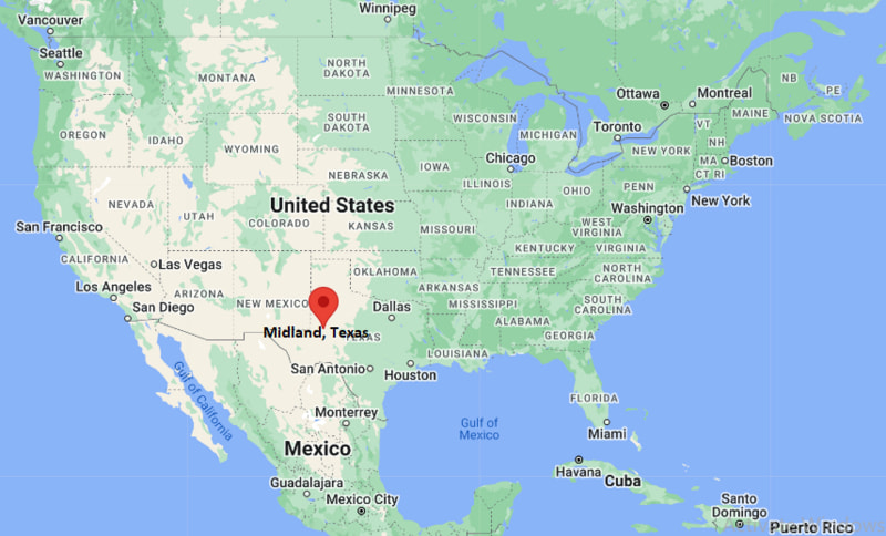
Midland Map, Texas, USA
Where is Midland?: The Google Map showing the location of Midland in the U.S. state of Texas.
Where is Midland Located?
Midland is a city located in the Midland County of Texas, United States. Midland lies between 35.9489566 Degrees North latitudes and 85.0269014 Degrees West longitudes. According to 2020 U.S.census, the population of Midland city is 132524 people and the city has a total area of 74.38 sq mi. The city has numerous parks and recreational facilities.
Most Viewed US Maps
| USA Sttae Map | USA Region Map | USA Road Map |
| USA County Map | Where is USA in World Map? | US ZIP Code Map |
| USA Time Zones Map | US State and Capitals Map | USA Physical Map |
Find 4,400+ U.S. Cities by State - Explore Their Locations and Get Detailed Information
Midland, Texas Quick Facts
| Fact | Details |
|---|---|
| City | Midland |
| County | Midland County |
| State | Texas |
| State Capital | Austin |
| US Region | South |
| Latitude | 31.9973° N |
| Longitude | 102.0779° W |
| Elevation | 2,871 ft (875 m) |
| Land Area | 75.8 sq mi |
| Water Area | 0.4 sq mi |
| Total Area | 76.2 sq mi |
| Population (2020 Census) | 132,524 |
| Population Density | Approximately 1,748 per sq mi |
| ZIP Codes | 79701, 79703, 79705, 79706, 79707, 79708, 79710, 79711, 79712 |
| Area Code | 432 |
| Time Zone Standard | Central Standard Time (CST, UTC-6) |
| Time Zone Daylight | Central Daylight Time (CDT, UTC-5) |
| Currency | US Dollar (USD) |
| FIPS Code | 48-48072 |
| Congressional District | Texas 23rd Congressional District |
Location and Surroundings
Midland is located in Midland County in West Texas within the Permian Basin. It lies between Odessa to the southwest and Stanton to the northeast along Interstate 20. The city is famous for its oil and natural gas industry, energy companies, and role as one of the leading economic centers of West Texas.
Nearby Cities to Midland, Texas
- Odessa, Texas - 20 mi Southwest
- Stanton, Texas - 20 mi Northeast
- Gardendale, Texas - 17 mi West
- Andrews, Texas - 35 mi Northwest
- Big Spring, Texas - 41 mi East
- Crane, Texas - 39 mi South
- Monahans, Texas - 55 mi Southwest
- Pecos, Texas - 95 mi Southwest
- Lamesa, Texas - 62 mi North
- Fort Stockton, Texas - 115 mi Southwest
Midland, Texas Climate and Weather Overview
| Month | Avg High (°F) | Avg Low (°F) | Avg Rainfall (in) |
|---|---|---|---|
| January | 59 | 31 | 0.6 |
| April | 79 | 50 | 0.8 |
| July | 95 | 70 | 1.8 |
| October | 81 | 53 | 1.4 |
| Annual | 78 | 50 | 14.6 |
| Climate Attribute | Details |
|---|---|
| Climate Classification (Köppen) | Cold Semi-Arid (BSk) |
| Annual Rainfall | About 15 inches |
| Annual Sunshine Days | Approximately 266 days |
| Hurricane/Tornado Risk | Low hurricane risk, moderate severe storm risk |
| Snowfall | About 5 inches annually |
Driving Distances from Midland, Texas
| City | State | Distance (mi) | Approx. Drive Time |
|---|---|---|---|
| Odessa | Texas | 20 | 25 min |
| Stanton | Texas | 20 | 20 min |
| Andrews | Texas | 35 | 40 min |
| Big Spring | Texas | 41 | 45 min |
| Crane | Texas | 39 | 45 min |
| Monahans | Texas | 55 | 55 min |
| Lamesa | Texas | 62 | 1 hr |
| Pecos | Texas | 95 | 1 hr 30 min |
| Fort Stockton | Texas | 115 | 1 hr 50 min |
| Lubbock | Texas | 118 | 2 hr |
Transportation and Connectivity in Midland, Texas
| Category | Details |
|---|---|
| Airport Name | Midland International Air & Space Port |
| IATA Code | MAF |
| Port | Not Applicable |
| Major Highways | I-20, TX-191, TX-158, Loop 250 |
| Train/Amtrak Service | No direct Amtrak service |
| Local Bus/Transit Service | EZ-Rider Transit |
- Interstate 20 - Main east-west route connecting Midland with Dallas and El Paso.
- State Highway 191 - Connects Midland with Odessa and western oilfield regions.
- State Highway 158 - Provides access to southeastern New Mexico and West Texas communities.
- Loop 250 - Major beltway serving commercial and residential areas around the city.
- Business Interstate 20 - Serves downtown Midland and local businesses.
- Farm to Market roads connect the city with oil and gas production areas throughout the Permian Basin.
Key Landmarks and Places to Visit in Midland, Texas
| Landmark Name | Type |
|---|---|
| Permian Basin Petroleum Museum | Museum |
| George W. Bush Childhood Home | Historic Site |
| Wagner Noël Performing Arts Center | Performing Arts Venue |
| I-20 Wildlife Preserve | Nature Preserve |
| Museum of the Southwest | Museum |
| Sibley Nature Center | Nature Center |
| Hogan Park | Park |
| Midland County Horseshoe Arena | Event Venue |
| CAF Airpower Museum | Aviation Museum |
| Bush Convention Center | Convention Center |
Waterbodies in Midland, Texas
Hogan Park Lake, Beal Park Pond, Monahans Draw, Mustang Draw, Midland Draw, Colorado River Basin, Bull Creek, Beals Creek, Moss Creek Lake, Twin Buttes Reservoir
Golf Courses in Midland, Texas
Ranchland Hills Golf Club, Hogan Park Golf Course, Green Tree Country Club, Nueva Vista Golf Club, Odessa Country Club, Sunset Country Club, Ratliff Ranch Golf Links, Hogan Park North Course, Hogan Park South Course, Mission Dorado Golf Course
Economy and Major Employers in Midland, Texas
| Sector | Major Employer or Industry | Notes |
|---|---|---|
| Energy | Oil and Natural Gas Industry | Foundation of the local economy. |
| Energy | Permian Basin Producers | Major employment source. |
| Healthcare | Midland Memorial Hospital | Largest healthcare provider in the city. |
| Education | Midland Independent School District | Major public employer. |
| Higher Education | Midland College | Important educational institution. |
| Finance | Banking and Financial Services | Supports regional business activity. |
| Construction | Energy Infrastructure Development | Driven by Permian Basin growth. |
| Transportation | Logistics and Oilfield Services | Supports energy operations across West Texas. |
Colleges and Schools in Midland, Texas
| Institution Name | Type | Level | Notable For |
|---|---|---|---|
| Midland College | Public | Community College | Workforce and transfer programs |
| Texas Tech University Health Sciences Center - Midland | Public | University | Medical education |
| The University of Texas Permian Basin | Public | University | Regional higher education |
| Midland Independent School District | Public | K-12 District | Largest school district in the city |
| Trinity School | Private | K-12 School | College preparatory education |
| Legacy Freshman High School | Public | K-12 School | Secondary education |
Midland, Texas - Key Historical Facts
- Midland was established in 1881 as a station on the Texas and Pacific Railway.
- The city received its name because it was located roughly midway between Fort Worth and El Paso.
- Early economic activity centered on ranching and agriculture across the High Plains region.
- The discovery of oil in the Permian Basin during the 1920s transformed Midland into a major energy center.
- Former U.S. Presidents George H. W. Bush and George W. Bush both lived in Midland during their early years.
- Today, Midland remains one of the most important oil and gas hubs in the United States.
References
- City of Midland, Texas
- Midland County Government
- U.S. Census Bureau
- Texas Parks and Wildlife Department
- Travel Texas Tourism
Texas Maps and Info
- Where is Abilene
- Where is Allen
- Where is Alvin
- Where is Amarillo
- Where is Atascocita
- Where is Balch Springs
- Where is Baytown
- Where is Beaumont
- Where is Bedford
- Where is Belton
- Where is Benbrook
- Where is Big Spring
- Where is Brownsville
- Where is Brushy Creek
- Where is Bryan
- Where is Burleson
- Where is Canyon Lake
- Where is Carrollton
- Where is Cedar Hill
- Where is Cedar Park
- Where is Channelview
- Where is Cibolo
- Where is Cleburne
- Where is Cloverleaf
- Where is College Station
- Where is Colleyville
- Where is Conroe
- Where is Converse
- Where is Coppell
- Where is Copperas Cove
- Where is Corinth
- Where is Corsicana
- Where is Deer Park
- Where is Del Rio
- Where is Denison
- Where is Denton
- Where is DeSoto
- Where is Duncanville
- Where is Eagle Pass
- Where is Edinburg
- Where is Euless
- Where is Farmers Branch
- Where is Flower Mound
- Where is Forney
- Where is Fort Hood
- Where is Friendswood
- Where is Frisco
- Where is Fulshear
- Where is Galveston
- Where is Georgetown
- Where is Grand Prairie
- Where is Grapevine
- Where is Greenville
- Where is Haltom City
- Where is Harker Heights
- Where is Harlingen
- Where is Horizon City
- Where is Huntsville
- Where is Hurst
- Where is Hutto
- Where is Katy
- Where is Keller
- Where is Kerrville
- Where is Killeen
- Where is Kingsville
- Where is Kyle
- Where is La Porte
- Where is Lake Jackson
- Where is Lakeway
- Where is Lancaster
- Where is League City
- Where is Leander
- Where is Lewisville
- Where is Little Elm
- Where is Longview
- Where is Lufkin
- Where is Mansfield
- Where is Marshall
- Where is McAllen
- Where is McKinney
- Where is Mesquite
- Where is Midland
- Where is Midlothian
- Where is Mission
- Where is Mission Bend
- Where is Missouri City
- Where is Murphy
- Where is Nacogdoches
- Where is New Braunfels
- Where is North Richland Hills
- Where is Odessa
- Where is Paris
- Where is Pasadena
- Where is Pearland
- Where is Pecan Grove
- Where is Pflugerville
- Where is Pharr
- Where is Plano
- Where is Port Arthur
- Where is Prosper
- Where is Richardson
- Where is Rockwall
- Where is Rosenberg
- Where is Round Rock
- Where is Rowlett
- Where is Sachse
- Where is Saginaw
- Where is San Angelo
- Where is San Antonio
- Where is San Benito
- Where is San Juan
- Where is San Marcos
- Where is Schertz
- Where is Seguin
- Where is Sherman
- Where is Socorro
- Where is Southlake
- Where is Spring
- Where is Stephenville
- Where is Sugar Land
- Where is Temple
- Where is Texarkana
- Where is Texas City
- Where is The Colony
- Where is The Woodlands
- Where is Timberwood Park
- Where is Tyler
- Where is University Park
- Where is Victoria
- Where is Waco
- Where is Watauga
- Where is Waxahachie
- Where is Weatherford
- Where is Weslaco
- Where is West Odessa
- Where is Wichita Falls
- Where is Wylie