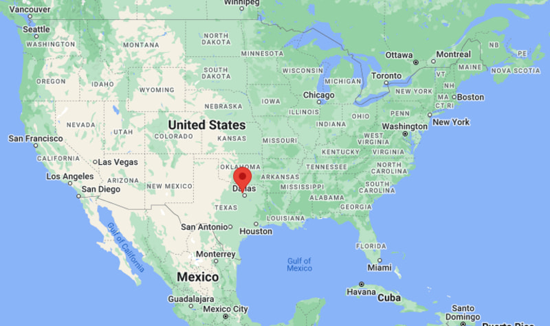
Where is Coppell Located? - Coppell is a city located in the Dallas County of Texas, United States. Coppell lies between 34.9387279 Degrees North latitudes and 82.2270568 Degrees West longitudes.
Location Map of Coppell, Texas
Coppell Map, Texas, USA
Where is Coppell?: The Google Map showing the location of Coppell in the U.S. state of Texas.
Where is Coppell Located?
Coppell is a city located in the Dallas County of Texas, United States. Coppell lies between 34.9387279 Degrees North latitudes and 82.2270568 Degrees West longitudes. According to 2020 U.S.census, the population of Coppell city is 42983 people and the city has a total area of 14.5 sq mi. The city has numerous parks and recreational facilities.
Dallas County (mostly), with small portions in Denton County
State
Texas
State Capital
Austin
US Region
South
Latitude
32.9546° N
Longitude
97.0150° W
Elevation
~560 ft (171 m)
Land Area
~14.5 sq mi
Water Area
~0.2 sq mi
Total Area
~14.7 sq mi
Population (2020 Census)
~42,000
Population Density
~2,900 per sq mi
ZIP Codes
75019
Area Code
214, 469, 972
Time Zone Standard
Central Standard Time (CST, UTC-6)
Time Zone Daylight
Central Daylight Time (CDT, UTC-5)
FIPS Code
48-17096
Established
Incorporated 1955
Nearby Cities to Coppell, Texas
Dallas, Texas - 20 mi Southeast
Fort Worth, Texas - 25 mi Southwest
Irving, Texas - 8 mi South
Lewisville, Texas - 6 mi North
Grapevine, Texas - 5 mi Northeast
Carrollton, Texas - 7 mi East
Flower Mound, Texas - 8 mi Northwest
Plano, Texas - 20 mi Northeast
Addison, Texas - 14 mi East
Arlington, Texas - 20 mi South
Coppell, Texas Climate and Weather Overview
Month
Avg High (°F)
Avg Low (°F)
Avg Precipitation
January
56
36
2.1 in
April
75
55
3.2 in
July
96
76
2.3 in
October
78
58
3.0 in
Annual
76
56
~38–40 in
Climate Summary
Climate Attribute
Details
Climate Type (Köppen)
Humid subtropical (Cfa)
Summers
Hot and humid
Winters
Mild with occasional cold fronts
Severe Weather Risk
Thunderstorms, hail, tornado risk (North Texas region)
Drought Risk
Moderate in summer months
Driving Distances from Coppell, Texas
City
State
Distance (mi)
Approx. Drive Time
Dallas
Texas
20
25–30 min
Fort Worth
Texas
25
30–40 min
Irving
Texas
8
10–15 min
Plano
Texas
20
25–30 min
Arlington
Texas
20
25–35 min
Frisco
Texas
25
30–40 min
Denton
Texas
30
35–45 min
Waco
Texas
100
1 hr 40 min
Oklahoma City
Oklahoma
200
3 hr 10 min
Austin
Texas
195
3 hr
Transportation and Connectivity in Coppell, Texas
Feature
Details
Nearest Airport
Dallas/Fort Worth International Airport
IATA Code
DFW
Secondary Airport
Dallas Love Field (DAL)
Major Highways
I-635, SH-121, I-35E (nearby), President George Bush Turnpike
Rail Service
DART commuter rail access nearby (DFW metro)
Public Transit
DART bus connections (limited within city)
I-635 - Major loop highway connecting Coppell to Dallas metro suburbs.
SH-121 - Key corridor linking DFW Airport and northern suburbs.
George Bush Turnpike - Important east-west regional expressway.
I-35E - Major north-south interstate through Dallas region.
DFW Airport access roads - Direct connectivity to one of the busiest airports in the US.
Key Landmarks and Places to Visit in Coppell, Texas
Landmark Name
Type
Coppell Nature Park
Nature Preserve
Andrew Brown Park East
City Park
Andrew Brown Park West
City Park
Kid Country Playground
Community Playground
Coppell Arts Center
Arts & Performance Venue
William T. Cozby Public Library
Library
Trinity River Greenbelt
Nature & Trail Area
Andy Brown Park Trail System
Walking & Cycling Trails
MacArthur Park (nearby Irving)
Recreation Park
Grapevine Lake (nearby)
Lake Recreation Area
Colleges and Universities Near Coppell, Texas
Institution Name
Type
Level
Notable For
Dallas College - North Lake Campus
Public
Community College
Career training and transfer programs
University of North Texas
Public
University
Business, music, engineering, research
University of Texas at Dallas
Public
University
STEM, computer science, engineering
Southern Methodist University
Private
University
Law, business, liberal arts
Texas Christian University
Private
University
Business, health sciences, liberal arts
Waterbodies in Coppell, Texas
Trinity River (regional watershed), Denton Creek, Grapevine Lake (nearby), Elm Fork Trinity River, Cottonwood Creek, Coppell Wetland Basin, Lake Lewisville (regional), Hackberry Creek (nearby), Millers Creek, Valley Ranch drainage lakes
Golf Courses in Coppell, Texas
Riverchase Golf Club, Cowboys Golf Club (nearby Grapevine), Hackberry Creek Country Club, Bear Creek Golf Club, Los Rios Golf Club, Tour 18 Dallas, Grapevine Municipal Golf Course, North Texas Golf Center
Coppell, Texas - Key Historical Facts
Coppell began as a small farming and railroad community in the late 19th century.
The city was originally known as Gibbs Station before being renamed Coppell.
Railroad expansion helped establish early trade and settlement patterns.
Suburban growth accelerated after the opening of DFW International Airport in 1974.
Modern Coppell developed into a master-planned suburban community focused on families and schools.
Today, it is known for its high quality of life, parks system, and proximity to major Dallas employment centers.