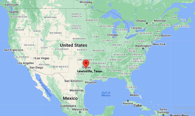
Where is Lewisville Located? - Lewisville is a city located in the Denton County of Texas, United States. Lewisville lies between 44.4908172 Degrees North latitudes and 103.8593698 Degrees West longitudes.
Location Map of Lewisville, Texas

Lewisville Map, Texas, USA
Where is Lewisville?: The Google Map showing the location of Lewisville in the U.S. state of Texas.
Where is Lewisville Located?
Lewisville is a city located in the Denton County of Texas, United States. Lewisville lies between 44.4908172 Degrees North latitudes and 103.8593698 Degrees West longitudes. According to 2020 U.S.census, the population of Lewisville city is 111822 people and the city has a total area of 36.7 sq mi. The city has numerous parks and recreational facilities.
Most Viewed US Maps
Lewisville City Facts, Texas
| City Name | Lewisville |
| County | Denton County |
| State | Texas |
| Country | United States |
| U.S. Region | West South Central |
| Coordinates | 33.0463292° N, 96.9941903° W |
| Latitude | 33.0463292 |
| Longitude | -96.9941903 |
| Population (2020 Census) | 111822 |
| Population Density (Sq mi) | 3182 |
| Area (Sq mi) | 36.7 |
| Currency | US Dollar, $ (USD) |
| Time Zone | Central Time - UTC?06:00 (Standard), UTC?05:00 (DST) |
Texas Maps and Info
- Where is Abilene
- Where is Allen
- Where is Alvin
- Where is Amarillo
- Where is Atascocita
- Where is Balch Springs
- Where is Baytown
- Where is Beaumont
- Where is Bedford
- Where is Belton
- Where is Benbrook
- Where is Big Spring
- Where is Brownsville
- Where is Brushy Creek
- Where is Bryan
- Where is Burleson
- Where is Canyon Lake
- Where is Carrollton
- Where is Cedar Hill
- Where is Cedar Park
- Where is Channelview
- Where is Cibolo
- Where is Cleburne
- Where is Cloverleaf
- Where is College Station
- Where is Colleyville
- Where is Conroe
- Where is Converse
- Where is Coppell
- Where is Copperas Cove
- Where is Corinth
- Where is Corsicana
- Where is Deer Park
- Where is Del Rio
- Where is Denison
- Where is Denton
- Where is DeSoto
- Where is Duncanville
- Where is Eagle Pass
- Where is Edinburg
- Where is Euless
- Where is Farmers Branch
- Where is Flower Mound
- Where is Forney
- Where is Fort Hood
- Where is Friendswood
- Where is Frisco
- Where is Fulshear
- Where is Galveston
- Where is Georgetown
- Where is Grand Prairie
- Where is Grapevine
- Where is Greenville
- Where is Haltom City
- Where is Harker Heights
- Where is Harlingen
- Where is Horizon City
- Where is Huntsville
- Where is Hurst
- Where is Hutto
- Where is Katy
- Where is Keller
- Where is Kerrville
- Where is Killeen
- Where is Kingsville
- Where is Kyle
- Where is La Porte
- Where is Lake Jackson
- Where is Lakeway
- Where is Lancaster
- Where is League City
- Where is Leander
- Where is Lewisville
- Where is Little Elm
- Where is Longview
- Where is Lufkin
- Where is Mansfield
- Where is Marshall
- Where is McAllen
- Where is McKinney
- Where is Mesquite
- Where is Midland
- Where is Midlothian
- Where is Mission
- Where is Mission Bend
- Where is Missouri City
- Where is Murphy
- Where is Nacogdoches
- Where is New Braunfels
- Where is North Richland Hills
- Where is Odessa
- Where is Paris
- Where is Pasadena
- Where is Pearland
- Where is Pecan Grove
- Where is Pflugerville
- Where is Pharr
- Where is Plano
- Where is Port Arthur
- Where is Prosper
- Where is Richardson
- Where is Rockwall
- Where is Rosenberg
- Where is Round Rock
- Where is Rowlett
- Where is Sachse
- Where is Saginaw
- Where is San Angelo
- Where is San Antonio
- Where is San Benito
- Where is San Juan
- Where is San Marcos
- Where is Schertz
- Where is Seguin
- Where is Sherman
- Where is Socorro
- Where is Southlake
- Where is Spring
- Where is Stephenville
- Where is Sugar Land
- Where is Temple
- Where is Texarkana
- Where is Texas City
- Where is The Colony
- Where is The Woodlands
- Where is Timberwood Park
- Where is Tyler
- Where is University Park
- Where is Victoria
- Where is Waco
- Where is Watauga
- Where is Waxahachie
- Where is Weatherford
- Where is Weslaco
- Where is West Odessa
- Where is Wichita Falls
- Where is Wylie
