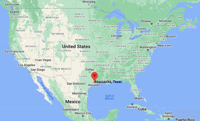
Where is Atascocita Located? - Atascocita is a city located in the Harris County of Texas, United States. Atascocita lies between 29.99883 Degrees North latitudes and -95.1766 Degrees West longitudes.
Location Map of Atascocita, Texas
Atascocita Map, Texas, USA
Where is Atascocita?: The Google Map showing the location of Atascocita in the U.S. state of Texas.
Where is Atascocita Located?
Atascocita is a census-designated place located in the Harris County of Texas, United States. Atascocita lies at approximately 29.99883 Degrees North latitude and -95.1766 Degrees West longitude. According to the 2020 U.S. Census, the population of Atascocita CDP is 88,174 people and the community has a total area of 23.991 sq mi. The community has numerous parks and recreational facilities.
Nearby Cities and Communities to Atascocita, Texas
Humble, Texas - 5 mi Southwest
Kingwood, Texas - 6 mi East
Aldine, Texas - 12 mi Southwest
Spring, Texas - 18 mi Northwest
Crosby, Texas - 16 mi Southeast
New Caney, Texas - 15 mi Northeast
The Woodlands, Texas - 28 mi Northwest
Baytown, Texas - 25 mi Southeast
Pasadena, Texas - 28 mi South
Houston, Texas - 22 mi Southwest
Atascocita, Texas Climate and Weather Overview
Month
Avg High (°F)
Avg Low (°F)
Avg Precipitation (in)
January
63
43
4.1
April
79
59
3.6
July
94
75
3.8
October
83
62
4.8
Annual
81
61
50.0
Climate Attribute
Details
Climate Classification (Köppen)
Cfa - Humid Subtropical
Annual Precipitation
Approximately 50 inches
Annual Sunshine Days
Approximately 204 days
Severe Weather Risk
Hurricanes, Flooding, Thunderstorms and Tornadoes
Average Snowfall
Rare
Driving Distances from Atascocita, Texas
City
State
Distance (mi)
Approx. Drive Time
Humble
Texas
5
10 min
Kingwood
Texas
6
10 min
Aldine
Texas
12
20 min
New Caney
Texas
15
20 min
Crosby
Texas
16
25 min
Spring
Texas
18
25 min
Houston
Texas
22
35 min
Baytown
Texas
25
35 min
The Woodlands
Texas
28
40 min
Pasadena
Texas
28
40 min
Transportation and Connectivity in Atascocita, Texas
Nearest Airport
George Bush Intercontinental Airport
IATA Code
IAH
Major Airport
George Bush Intercontinental Airport (IAH)
Major Highways
FM 1960, Beltway 8, US Highway 59 (I-69), State Highway 99
Rail Service
Freight Rail Service Nearby
Public Transit
METRO Regional Services
Atascocita is a large master-planned suburban community located northeast of Houston.
The area is known for residential neighborhoods, golf courses and access to Lake Houston.
Healthcare, retail, education and professional services are major employment sectors.
George Bush Intercontinental Airport is located a short drive from the community.
Atascocita has experienced significant population growth as part of the expanding Houston metropolitan area.
Key Landmarks and Places to Visit in Atascocita, Texas
Landmark Name
Type
Lake Houston
Reservoir and Recreation Area
Atascocita Golf Club
Golf Course
Lindsay/Lyons Park and Sports Complex
Sports Facility
Eagle Springs Sports Complex
Recreation Area
Atascocita Town Center
Shopping District
Jesse H. Jones Park & Nature Center
Nature Preserve
Humble Museum
Museum
Deussen Park
Regional Park
Old MacDonald's Farm
Family Attraction
Mercer Botanic Gardens
Nearby Botanical Garden
Colleges and Universities Near Atascocita, Texas
Institution Name
Type
Distance
Notable For
Lone Star College-Kingwood
Community College
6 mi
Academic transfer and workforce programs
University of Houston-Downtown
Public University
22 mi
Business and public service programs
University of Houston
Public University
26 mi
Research and higher education
Sam Houston State University - The Woodlands Center
Public University
30 mi
Professional and graduate studies
Rice University
Private University
28 mi
Research and engineering
Waterbodies in and Near Atascocita, Texas
Lake Houston, San Jacinto River, Spring Creek, Luce Bayou, Lake Houston Wilderness Area Waterways, Peach Creek, Cypress Creek, East Fork San Jacinto River, Caney Creek, Sheldon Reservoir
Golf Courses in and Near Atascocita, Texas
Atascocita Golf Club, Walden on Lake Houston Golf and Country Club, Tour 18 Golf Course, The Clubs of Kingwood, Redstone Golf Club, Eagle Pointe Golf Club, River Terrace Golf Course, Deerbrook Golf Club
Atascocita, Texas - Key Historical Facts
Atascocita was originally a rural area near Lake Houston and the San Jacinto River.
Large-scale residential development began during the 1970s and 1980s as Houston expanded outward.
The creation of master-planned communities transformed the area into a major suburban population center.
Proximity to George Bush Intercontinental Airport contributed to economic and residential growth.
The development of Lake Houston recreational facilities increased the area's appeal for families and outdoor enthusiasts.
Today, Atascocita is one of the largest unincorporated communities in Texas and an important part of the Houston metropolitan region.