Map of Dallas County - Dallas County is a county located in the U.S. state of Texas. Dallas County Map showing cities, highways, important places and water bodies. Get Where is Dallas County located in the map, major cities in Dallas county, population, areas, and places of interest.
Map of Dallas County, Texas
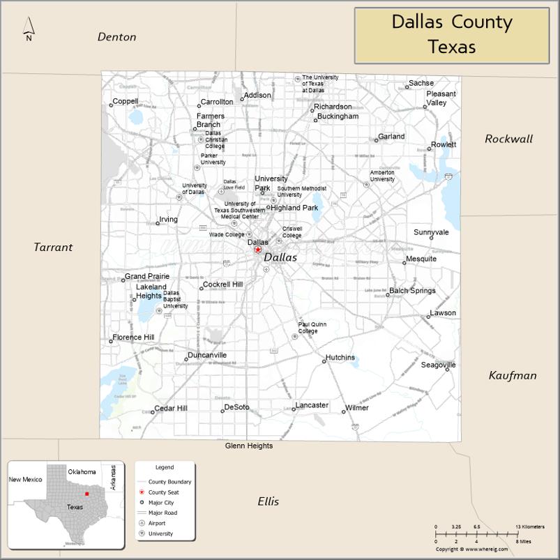
About Dallas County Map, Texas: The map showing the county boundary, county seat, major cities, highways, water bodies and neighbouring counties.
Related Texas Maps
Map of Dallas County, Texas
Dallas County is a county located in the U.S. state of Texas. It's county seat is Dallas. As per 2020 census, the population of Dallas County is 2586050 people and population density is square miles. According to the United States Census Bureau, the county has a total area of 880 sq mi (2,279 km2). Dallas County was established on 1846.
Facts about Dallas County, Texas
| Country | United States |
| State | Texas |
| Region | North Texas / Dallas–Fort Worth Metroplex |
| County Seat | Dallas |
| Named After | Likely George Mifflin Dallas (U.S. Vice President) |
| Established | 1846 |
| Organized | 1846 |
| Coordinates | 32.7767° N, 96.7970° W |
| Total Area | 908 sq mi |
| Land Area | 873 sq mi |
| Water Area | 35 sq mi |
| Population (2020) | 2,613,539 |
| Population Rank | 2nd most populous county in Texas |
| Major Cities | Dallas, Garland, Irving, Mesquite, Grand Prairie (partially) |
| Main Industries | Technology, Finance, Transportation, Healthcare, Telecommunications |
| Major Airport | Dallas Love Field (DAL); DFW Airport (nearby, shared with Tarrant County) |
| Time Zone | Central Time (UTC−06:00) |
| Known For | Downtown Dallas skyline, Dealey Plaza, Major corporate headquarters, Arts District |
| Website | https://www.dallascounty.org |
Top Attractions in Dallas County, Texas
- The Sixth Floor Museum at Dealey Plaza – Museum about JFK’s life and legacy.
- Dallas Museum of Art – Major art museum with global collections.
- Dallas Arboretum & Botanical Garden – Lakeside gardens with seasonal floral displays.
- Perot Museum of Nature and Science – Interactive exhibits on science, dinosaurs, and technology.
- Reunion Tower – Observation deck offering panoramic city views.
- Dallas World Aquarium – Indoor rainforest and aquatic exhibits.
- Klyde Warren Park – Urban park with food trucks, events, and green space.
- Deep Ellum District – Music venues, murals, nightlife, and local dining.
- White Rock Lake Park – Popular spot for running, kayaking, and picnics.
- Dallas Zoo – Large zoo featuring wildlife habitats from around the world.
Cities and Towns in Dallas County, Texas
| Place | Type | Population (Census 2020) | Latitude & Longitude |
|---|---|---|---|
| Dallas (county seat) | City | 1304379 | 32.7767°N, 96.7970°W |
| Irving | City | 256684 | 32.8140°N, 96.9489°W |
| Garland | City | 246018 | 32.9126°N, 96.6389°W |
| Grand Prairie (partly in Tarrant County) | City | 196100 | 32.7459°N, 96.9978°W |
| Mesquite | City | 150108 | 32.7668°N, 96.5992°W |
| Richardson (partly in Collin County) | City | 119469 | 32.9483°N, 96.7299°W |
| Carrollton (partly in Denton and Collin counties) | City | 133434 | 32.9756°N, 96.8899°W |
| Rowlett (partly in Rockwall County) | City | 62435 | 32.9029°N, 96.5639°W |
| Cedar Hill | City | 49248 | 32.5885°N, 96.9561°W |
| DeSoto | City | 56812 | 32.5897°N, 96.8571°W |
| Duncanville | City | 39711 | 32.6518°N, 96.9083°W |
| Balch Springs | City | 27403 | 32.7287°N, 96.6228°W |
| Farmers Branch | City | 35708 | 32.9265°N, 96.8961°W |
| Coppell (partly in Denton County) | City | 42660 | 32.9546°N, 97.0150°W |
| University Park | City | 25122 | 32.8504°N, 96.8003°W |
| Highland Park | Town | 8954 | 32.8335°N, 96.8058°W |
| Hutchins | City | 5716 | 32.6496°N, 96.7130°W |
| Lancaster | City | 41400 | 32.5921°N, 96.7561°W |
| Seagoville | City | 17454 | 32.6396°N, 96.5383°W |
| Wilmer | City | 5682 | 32.5899°N, 96.6853°W |
| Cockrell Hill | City | 4124 | 32.7376°N, 96.8900°W |
| Glenn Heights (partly in Ellis County) | City | 14978 | 32.5482°N, 96.8569°W |
| Sunnyvale | Town | 6851 | 32.7965°N, 96.5600°W |
| Addison | Town | 16861 | 32.9618°N, 96.8292°W |
What are Major Roads and Highways in Dallas County
Major highways connect the county to nearby regions and cities.
- Interstate 20 - east-west route through southern Dallas County
- Interstate 30 - connects Dallas with Fort Worth and East Texas
- Interstate 35E - north-south route through Dallas and surrounding cities
- Interstate 45 - connects Dallas with Houston
- Interstate 635 (LBJ Freeway) - major beltway around northern Dallas
- U.S. Highway 75 (Central Expressway) - north toward Collin County
- President George Bush Turnpike - serves northern and eastern suburbs
- State Highway 121 - connects Dallas County with Denton and Collin counties
- State Highway 183 - links Dallas and Irving with Fort Worth
- Loop 12 - serves central and western portions of the county
What are Neighboring Counties of Dallas County
- Denton County (northwest)
- Collin County (north)
- Rockwall County (east)
- Kaufman County (southeast)
- Ellis County (south)
- Johnson County (southwest)
- Tarrant County (west)
Distance from Dallas County to Nearby Cities
The following distances are measured by road (driving).
- Dallas to Irving (Dallas County), Texas - 12 mi (19 km)
- Dallas to Garland (Dallas County), Texas - 15 mi (24 km)
- Dallas to Mesquite (Dallas County), Texas - 11 mi (18 km)
- Dallas to Richardson (Dallas County), Texas - 13 mi (21 km)
- Dallas to Grand Prairie (Dallas County), Texas - 15 mi (24 km)
- Dallas to Carrollton (Dallas County), Texas - 17 mi (27 km)
- Dallas to DeSoto (Dallas County), Texas - 16 mi (26 km)
- Dallas to Cedar Hill (Dallas County), Texas - 18 mi (29 km)
- Dallas to Plano (Collin County), Texas - 20 mi (32 km)
- Dallas to Denton (Denton County), Texas - 39 mi (63 km)
- Dallas to Rockwall (Rockwall County), Texas - 25 mi (40 km)
- Dallas to McKinney (Collin County), Texas - 33 mi (53 km)
- Dallas to Fort Worth (Tarrant County), Texas - 34 mi (55 km)
- Dallas to Waxahachie (Ellis County), Texas - 31 mi (50 km)
- Dallas to Terrell (Kaufman County), Texas - 32 mi (51 km)
Waterbodies in Dallas County
Trinity River, White Rock Lake, Joe Pool Lake, Mountain Creek Lake, Bachman Lake, Lake Ray Hubbard shoreline, Elm Fork Trinity River, West Fork Trinity River tributaries, White Rock Creek, Rowlett Creek, Ten Mile Creek, Cottonwood Creek, Turtle Creek, wetlands, reservoirs, flood-control lakes, and urban waterways
Best Golf Courses in Dallas County, Texas
| Golf Course | Location | Latitude & Longitude |
|---|---|---|
| TPC Las Colinas | Irving | 32.8931°N, 96.9568°W |
| Brookhaven Country Club | Farmers Branch | 32.9307°N, 96.8897°W |
| Dallas National Golf Club | Dallas | 32.7401°N, 96.9302°W |
| Tenison Park Golf Course | Dallas | 32.7998°N, 96.7609°W |
| Stevens Park Golf Course | Dallas | 32.7435°N, 96.8601°W |
| Cedar Crest Golf Course | Dallas | 32.7318°N, 96.7994°W |
| Golf Club of Dallas | Dallas | 32.6916°N, 96.9575°W |
| Luna Vista Golf Course | Dallas | 32.8875°N, 96.9121°W |
| Irving Golf Club | Irving | 32.8135°N, 96.9593°W |
| Mesquite Golf Club | Mesquite | 32.7825°N, 96.6108°W |
| Firewheel Golf Park | Garland | 32.9687°N, 96.6424°W |
| Sherrill Park Golf Course | Richardson | 32.9963°N, 96.6554°W |
| Cowboys Golf Club | Grapevine (Dallas County service area) | 32.9444°N, 97.0727°W |
Colleges and Universities in Dallas County, Texas
| Institution Name | Type | Level | Notable For |
|---|---|---|---|
| Southern Methodist University | Private | University | National research university in University Park |
| University of Texas at Dallas | Public | University | Major research and technology programs |
| Dallas College | Public | Community College | Large multi-campus community college system |
| University of North Texas at Dallas | Public | University | Public university serving southern Dallas County |
| Paul Quinn College | Private | University | Historically Black liberal arts institution |
| Dallas Baptist University | Private | University | Christian higher education programs |
| Parker University | Private | University | Health sciences and chiropractic education |
References
- U.S. Census Bureau - Dallas County QuickFacts
- Official Dallas County Website
- Texas State Historical Association - Dallas County
- Dallas College
- Southern Methodist University
- Anderson County Map
- Andrews County Map
- Angelina County Map
- Aransas County Map
- Archer County Map
- Armstrong County Map
- Atascosa County Map
- Austin County Map
- Bailey County Map
- Bandera County Map
- Bastrop County Map
- Baylor County Map
- Bee County Map
- Bell County Map
- Bexar County Map
- Blanco County Map
- Borden County Map
- Bosque County Map
- Bowie County Map
- Brazoria County Map
- Brazos County Map
- Brewster County Map
- Briscoe County Map
- Brooks County Map
- Brown County Map
- Burleson County Map
- Burnet County Map
- Caldwell County Map
- Calhoun County Map
- Callahan County Map
- Cameron County Map
- Camp County Map
- Carson County Map
- Cass County Map
- Castro County Map
- Chambers County Map
- Cherokee County Map
- Childress County Map
- Clay County Map
- Cochran County Map
- Coke County Map
- Coleman County Map
- Collin County Map
- Collingsworth County Map
- Colorado County Map
- Comal County Map
- Comanche County Map
- Concho County Map
- Cooke County Map
- Coryell County Map
- Cottle County Map
- Crane County Map
- Crockett County Map
- Crosby County Map
- Culberson County Map
- Dallam County Map
- Dallas County Map
- Dawson County Map
- Deaf Smith County Map
- Delta County Map
- Denton County Map
- DeWitt County Map
- Dickens County Map
- Dimmit County Map
- Donley County Map
- Duval County Map
- Eastland County Map
- Ector County Map
- Edwards County Map
- Ellis County Map
- El Paso County Map
- Erath County Map
- Falls County Map
- Fannin County Map
- Fayette County Map
- Fisher County Map
- Floyd County Map
- Foard County Map
- Fort Bend County Map
- Franklin County Map
- Freestone County Map
- Frio County Map
- Gaines County Map
- Galveston County Map
- Garza County Map
- Gillespie County Map
- Glasscock County Map
- Goliad County Map
- Gonzales County Map
- Gray County Map
- Grayson County Map
- Gregg County Map
- Grimes County Map
- Guadalupe County Map
- Hale County Map
- Hall County Map
- Hamilton County Map
- Hansford County Map
- Hardeman County Map
- Hardin County Map
- Harris County Map
- Harrison County Map
- Hartley County Map
- Haskell County Map
- Hays County Map
- Hemphill County Map
- Henderson County Map
- Hidalgo County Map
- Hill County Map
- Hockley County Map
- Hood County Map
- Hopkins County Map
- Houston County Map
- Howard County Map
- Hudspeth County Map
- Hunt County Map
- Hutchinson County Map
- Irion County Map
- Jack County Map
- Jackson County Map
- Jasper County Map
- Jeff Davis County Map
- Jefferson County Map
- Jim Hogg County Map
- Jim Wells County Map
- Johnson County Map
- Jones County Map
- Karnes County Map
- Kaufman County Map
- Kendall County Map
- Kenedy County Map
- Kent County Map
- Kerr County Map
- Kimble County Map
- King County Map
- Kinney County Map
- Kleberg County Map
- Knox County Map
- Lamar County Map
- Lamb County Map
- Lampasas County Map
- La Salle County Map
- Lavaca County Map
- Lee County Map
- Leon County Map
- Liberty County Map
- Limestone County Map
- Lipscomb County Map
- Live Oak County Map
- Llano County Map
- Loving County Map
- Lubbock County Map
- Lynn County Map
- McCulloch County Map
- McLennan County Map
- McMullen County Map
- Madison County Map
- Marion County Map
- Martin County Map
- Mason County Map
- Matagorda County Map
- Maverick County Map
- Medina County Map
- Menard County Map
- Midland County Map
- Milam County Map
- Mills County Map
- Mitchell County Map
- Montague County Map
- Montgomery County Map
- Moore County Map
- Morris County Map
- Motley County Map
- Nacogdoches County Map
- Navarro County Map
- Newton County Map
- Nolan County Map
- Nueces County Map
- Ochiltree County Map
- Oldham County Map
- Orange County Map
- Palo Pinto County Map
- Panola County Map
- Parker County Map
- Parmer County Map
- Pecos County Map
- Polk County Map
- Potter County Map
- Presidio County Map
- Rains County Map
- Randall County Map
- Reagan County Map
- Real County Map
- Red River County Map
- Reeves County Map
- Refugio County Map
- Roberts County Map
- Robertson County Map
- Rockwall County Map
- Runnels County Map
- Rusk County Map
- Sabine County Map
- San Augustine County Map
- San Jacinto County Map
- San Patricio County Map
- San Saba County Map
- Schleicher County Map
- Scurry County Map
- Shackelford County Map
- Shelby County Map
- Sherman County Map
- Smith County Map
- Somervell County Map
- Starr County Map
- Stephens County Map
- Sterling County Map
- Stonewall County Map
- Sutton County Map
- Swisher County Map
- Tarrant County Map
- Taylor County Map
- Terrell County Map
- Terry County Map
- Throckmorton County Map
- Titus County Map
- Tom Green County Map
- Travis County Map
- Trinity County Map
- Tyler County Map
- Upshur County Map
- Upton County Map
- Uvalde County Map
- Val Verde County Map
- Van Zandt County Map
- Victoria County Map
- Walker County Map
- Waller County Map
- Ward County Map
- Washington County Map
- Webb County Map
- Wharton County Map
- Wheeler County Map
- Wichita County Map
- Wilbarger County Map
- Willacy County Map
- Williamson County Map
- Wilson County Map
- Winkler County Map
- Wise County Map
- Wood County Map
- Yoakum County Map
- Young County Map
- Zapata County Map
- Zavala County Map
- Alabama Counties
- Alaska boroughs
- Arizona Counties
- Arkansas Counties
- California County Map
- Colorado Counties
- Connecticut Counties
- Delaware Counties
- Florida County Map
- Georgia County Map
- Hawaii Counties
- Idaho Counties
- Illinois Counties
- Indiana Counties
- Iowa Counties
- Kansas Counties
- Kentucky Counties
- Louisiana Counties
- Maine Counties
- Maryland Counties
- Massachusetts Counties
- Michigan County Map
- Minnesota Counties
- Mississippi Counties
- Missouri Counties
- Montana Counties
- Nebraska Counties
- Nevada Counties
- New York Counties
- New Hampshire Counties
- New Jersey Counties
- New Mexico Counties
- North Carolina Counties
- North Dakota Counties
- Ohio County Map
- Oklahoma Counties
- Oregon Counties
- Pennsylvania Counties
- Rhode Island Counties
- South Carolina Counties
- South Dakota Counties
- Map of Tennessee
- Texas County Map
- Utah Counties
- Vermont Counties
- Virginia Counties
- Washington Counties
- West Virginia Counties
- Wisconsin Counties
- Wyoming Counties
References
- ^ QuickFacts: Dallas County, Texas - United States Census Bureau
- ^ United States Census Bureau - Population and Housing Data
- ^ TIGER/Line Shapefiles - United States Census Bureau
- ^ United States Geological Survey (USGS)
- ^ National Geodetic Survey (NGS), NOAA
- ^ Official Website of Dallas County, Texas
- ^ Texas Department of Transportation (TxDOT)