Map of Angelina County - Angelina County is a county located in the U.S. state of Texas. Angelina County Map showing cities, highways, important places and water bodies. Get Where is Angelina County located in the map, major cities in Angelina county, population, areas, and places of interest.
Map of Angelina County, Texas
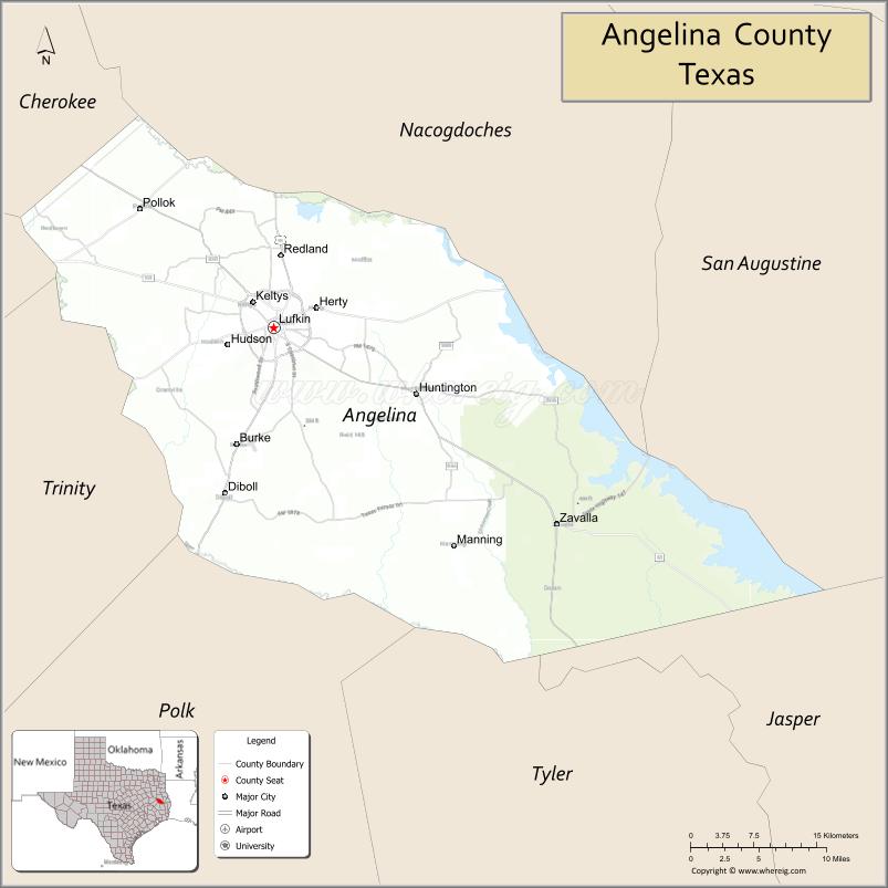
About Angelina County Map, Texas: The map showing the county boundary, county seat, major cities, highways, water bodies and neighbouring counties.
Related Texas Maps
Map of Angelina County, Texas
Angelina County is a county located in the U.S. state of Texas. It's county seat is Lufkin. As per 2020 census, the population of Angelina County is 86506 people and population density is square miles. According to the United States Census Bureau, the county has a total area of 802 sq mi (2,077 km2). Angelina County was established on 1846.
Facts about Angelina County, Texas
| Country | United States |
| State | Texas |
| Region | East Texas / Piney Woods |
| County Seat | Lufkin |
| Named After | Angelina, a Native American woman who aided early Spanish missionaries |
| Established | 1846 |
| Organized | 1846 |
| Coordinates | 31.2546° N, 94.6090° W |
| Total Area | 865 sq mi |
| Land Area | 798 sq mi |
| Water Area | 67 sq mi |
| Population (2020) | 86,395 |
| Population Rank | Mid-sized East Texas county |
| Major City | Lufkin |
| Main Industries | Forestry, Manufacturing, Healthcare, Retail |
| Major Airport | Angelina County Airport |
| Time Zone | Central Time (UTC−06:00) |
| Known For | Texas Forestry Museum, Ellen Trout Zoo, Angelina National Forest |
| Website | https://www.angelinacounty.net |
Top Attractions in Angelina County, Texas
- Ellen Trout Zoo – Family-friendly zoo with global wildlife.
- Angelina National Forest – Forest area for hiking, camping, and nature viewing.
- Museum of East Texas – Art and local history exhibits.
- Kit McConnico Park – Park with trails, sports fields, and picnic spaces.
- Azalea Trail (Lufkin) – Scenic spring driving route lined with azaleas.
- Pine Valley Raceway – Drag racing track with year-round events.
- Ratliff Lake Recreation Area – Lake for swimming, fishing, and camping.
- Downtown Lufkin – Shops, murals, and historic landmarks.
- Texas Forestry Museum – Exhibits on the history of Texas forestry.
- Jones Park – Green space with walking paths and playgrounds.
Cities and Towns in Angelina County, Texas
| Place | Type | Population (Census 2020) | Latitude & Longitude |
|---|---|---|---|
| Lufkin (county seat) | City | 34990 | 31.3382°N, 94.7291°W |
| Diboll | City | 4549 | 31.1874°N, 94.7827°W |
| Hudson | City | 4849 | 31.3274°N, 94.7788°W |
| Huntington | City | 2048 | 31.2774°N, 94.5763°W |
| Zavalla | City | 647 | 31.1588°N, 94.4135°W |
| Burke | Town | 737 | 31.2416°N, 94.7574°W |
| Redland | Census Designated Place (CDP) | 1112 | 31.3798°N, 94.7564°W |
| Pollok | Unincorporated Community | N/A | 31.4380°N, 94.8730°W |
| Herty | Unincorporated Community | N/A | 31.2960°N, 94.6950°W |
| Homer | Unincorporated Community | N/A | 31.4209°N, 94.6647°W |
| Keltys | Unincorporated Community | N/A | 31.3636°N, 94.6955°W |
| Manning | Unincorporated Community | N/A | 31.2970°N, 94.8710°W |
| Moffett | Unincorporated Community | N/A | 31.3694°N, 94.6205°W |
| Central | Unincorporated Community | N/A | 31.3652°N, 94.8261°W |
| Clawson | Unincorporated Community | N/A | 31.4082°N, 94.7701°W |
What are Major Roads and Highways in Angelina County
Major highways connect the county to nearby regions and cities.
- U.S. Highway 59 (future Interstate 69) - north toward Nacogdoches and south toward Livingston
- U.S. Highway 69 - north toward Alto and south toward Woodville
- U.S. Highway 287 - southwest toward Corrigan and southeast toward Beaumont
- Texas State Highway 7 - east toward Center and west toward Crockett
- Texas State Highway 63 - east toward Jasper and west toward Zavalla
- Texas State Highway 94 - west toward Trinity and east toward Lufkin
- Texas State Highway 103 - east toward San Augustine and west toward Etoile
- Texas State Highway 147 - south toward San Augustine County
- Farm to Market Road 1818 - serves eastern Angelina County
What are Neighboring Counties of Angelina County
- Nacogdoches County (north)
- San Augustine County (east)
- Jasper County (southeast)
- Tyler County (south)
- Polk County (southwest)
- Trinity County (west)
- Cherokee County (northwest)
Distance from Angelina County to Nearby Cities
The following distances are measured by road (driving).
- Lufkin to Nacogdoches (Nacogdoches County), Texas - 21 mi (34 km)
- Lufkin to Livingston (Polk County), Texas - 46 mi (74 km)
- Lufkin to Crockett (Houston County), Texas - 49 mi (79 km)
- Lufkin to Jasper (Jasper County), Texas - 59 mi (95 km)
- Lufkin to Center (Shelby County), Texas - 67 mi (108 km)
- Lufkin to Henderson (Rusk County), Texas - 69 mi (111 km)
- Lufkin to Huntsville (Walker County), Texas - 73 mi (117 km)
- Lufkin to Longview (Gregg County), Texas - 104 mi (167 km)
- Lufkin to Beaumont (Jefferson County), Texas - 108 mi (174 km)
- Lufkin to College Station (Brazos County), Texas - 124 mi (200 km)
- Lufkin to Houston (Harris County), Texas - 121 mi (195 km)
- Lufkin to Tyler (Smith County), Texas - 95 mi (153 km)
- Lufkin to Shreveport, Louisiana - 132 mi (212 km)
- Lufkin to Dallas (Dallas County), Texas - 170 mi (274 km)
- Lufkin to Austin (Travis County), Texas - 220 mi (354 km)
Waterbodies in Angelina County
Angelina River, Sam Rayburn Reservoir, Lake Sam Rayburn, Neches River watershed, Attoyac Bayou, Ayish Bayou, Alazan Bayou, Shawnee Creek, Mud Creek, Sandy Creek, Rocky Creek, Paper Mill Creek, Kurth Lake, Bayou LaNana watershed, Angelina National Forest wetlands, numerous ponds and tributaries
Best Golf Courses in Angelina County, Texas
| Golf Course | Location | Latitude & Longitude |
|---|---|---|
| Crown Colony Country Club | Lufkin | 31.2838°N, 94.7714°W |
| Rayburn Resort Golf Course | Brookeland | 31.0839°N, 94.0144°W |
| Pines Golf Club | Lufkin | 31.2721°N, 94.6993°W |
Colleges and Universities in Angelina County, Texas
| Institution Name | Type | Level | Notable For |
|---|---|---|---|
| Angelina College | Public | Community College | Largest higher education institution in the county |
| Academy of Hair Design | Private | College | Cosmetology training |
| East Texas Cosmetology College | Private | College | Beauty and salon education |
References
- U.S. Census Bureau - Angelina County QuickFacts
- Official Angelina County Website
- Texas State Historical Association - Angelina County
- Angelina College
- Texas Department of Transportation
- Anderson County Map
- Andrews County Map
- Angelina County Map
- Aransas County Map
- Archer County Map
- Armstrong County Map
- Atascosa County Map
- Austin County Map
- Bailey County Map
- Bandera County Map
- Bastrop County Map
- Baylor County Map
- Bee County Map
- Bell County Map
- Bexar County Map
- Blanco County Map
- Borden County Map
- Bosque County Map
- Bowie County Map
- Brazoria County Map
- Brazos County Map
- Brewster County Map
- Briscoe County Map
- Brooks County Map
- Brown County Map
- Burleson County Map
- Burnet County Map
- Caldwell County Map
- Calhoun County Map
- Callahan County Map
- Cameron County Map
- Camp County Map
- Carson County Map
- Cass County Map
- Castro County Map
- Chambers County Map
- Cherokee County Map
- Childress County Map
- Clay County Map
- Cochran County Map
- Coke County Map
- Coleman County Map
- Collin County Map
- Collingsworth County Map
- Colorado County Map
- Comal County Map
- Comanche County Map
- Concho County Map
- Cooke County Map
- Coryell County Map
- Cottle County Map
- Crane County Map
- Crockett County Map
- Crosby County Map
- Culberson County Map
- Dallam County Map
- Dallas County Map
- Dawson County Map
- Deaf Smith County Map
- Delta County Map
- Denton County Map
- DeWitt County Map
- Dickens County Map
- Dimmit County Map
- Donley County Map
- Duval County Map
- Eastland County Map
- Ector County Map
- Edwards County Map
- Ellis County Map
- El Paso County Map
- Erath County Map
- Falls County Map
- Fannin County Map
- Fayette County Map
- Fisher County Map
- Floyd County Map
- Foard County Map
- Fort Bend County Map
- Franklin County Map
- Freestone County Map
- Frio County Map
- Gaines County Map
- Galveston County Map
- Garza County Map
- Gillespie County Map
- Glasscock County Map
- Goliad County Map
- Gonzales County Map
- Gray County Map
- Grayson County Map
- Gregg County Map
- Grimes County Map
- Guadalupe County Map
- Hale County Map
- Hall County Map
- Hamilton County Map
- Hansford County Map
- Hardeman County Map
- Hardin County Map
- Harris County Map
- Harrison County Map
- Hartley County Map
- Haskell County Map
- Hays County Map
- Hemphill County Map
- Henderson County Map
- Hidalgo County Map
- Hill County Map
- Hockley County Map
- Hood County Map
- Hopkins County Map
- Houston County Map
- Howard County Map
- Hudspeth County Map
- Hunt County Map
- Hutchinson County Map
- Irion County Map
- Jack County Map
- Jackson County Map
- Jasper County Map
- Jeff Davis County Map
- Jefferson County Map
- Jim Hogg County Map
- Jim Wells County Map
- Johnson County Map
- Jones County Map
- Karnes County Map
- Kaufman County Map
- Kendall County Map
- Kenedy County Map
- Kent County Map
- Kerr County Map
- Kimble County Map
- King County Map
- Kinney County Map
- Kleberg County Map
- Knox County Map
- Lamar County Map
- Lamb County Map
- Lampasas County Map
- La Salle County Map
- Lavaca County Map
- Lee County Map
- Leon County Map
- Liberty County Map
- Limestone County Map
- Lipscomb County Map
- Live Oak County Map
- Llano County Map
- Loving County Map
- Lubbock County Map
- Lynn County Map
- McCulloch County Map
- McLennan County Map
- McMullen County Map
- Madison County Map
- Marion County Map
- Martin County Map
- Mason County Map
- Matagorda County Map
- Maverick County Map
- Medina County Map
- Menard County Map
- Midland County Map
- Milam County Map
- Mills County Map
- Mitchell County Map
- Montague County Map
- Montgomery County Map
- Moore County Map
- Morris County Map
- Motley County Map
- Nacogdoches County Map
- Navarro County Map
- Newton County Map
- Nolan County Map
- Nueces County Map
- Ochiltree County Map
- Oldham County Map
- Orange County Map
- Palo Pinto County Map
- Panola County Map
- Parker County Map
- Parmer County Map
- Pecos County Map
- Polk County Map
- Potter County Map
- Presidio County Map
- Rains County Map
- Randall County Map
- Reagan County Map
- Real County Map
- Red River County Map
- Reeves County Map
- Refugio County Map
- Roberts County Map
- Robertson County Map
- Rockwall County Map
- Runnels County Map
- Rusk County Map
- Sabine County Map
- San Augustine County Map
- San Jacinto County Map
- San Patricio County Map
- San Saba County Map
- Schleicher County Map
- Scurry County Map
- Shackelford County Map
- Shelby County Map
- Sherman County Map
- Smith County Map
- Somervell County Map
- Starr County Map
- Stephens County Map
- Sterling County Map
- Stonewall County Map
- Sutton County Map
- Swisher County Map
- Tarrant County Map
- Taylor County Map
- Terrell County Map
- Terry County Map
- Throckmorton County Map
- Titus County Map
- Tom Green County Map
- Travis County Map
- Trinity County Map
- Tyler County Map
- Upshur County Map
- Upton County Map
- Uvalde County Map
- Val Verde County Map
- Van Zandt County Map
- Victoria County Map
- Walker County Map
- Waller County Map
- Ward County Map
- Washington County Map
- Webb County Map
- Wharton County Map
- Wheeler County Map
- Wichita County Map
- Wilbarger County Map
- Willacy County Map
- Williamson County Map
- Wilson County Map
- Winkler County Map
- Wise County Map
- Wood County Map
- Yoakum County Map
- Young County Map
- Zapata County Map
- Zavala County Map
- Alabama Counties
- Alaska boroughs
- Arizona Counties
- Arkansas Counties
- California County Map
- Colorado Counties
- Connecticut Counties
- Delaware Counties
- Florida County Map
- Georgia County Map
- Hawaii Counties
- Idaho Counties
- Illinois Counties
- Indiana Counties
- Iowa Counties
- Kansas Counties
- Kentucky Counties
- Louisiana Counties
- Maine Counties
- Maryland Counties
- Massachusetts Counties
- Michigan County Map
- Minnesota Counties
- Mississippi Counties
- Missouri Counties
- Montana Counties
- Nebraska Counties
- Nevada Counties
- New York Counties
- New Hampshire Counties
- New Jersey Counties
- New Mexico Counties
- North Carolina Counties
- North Dakota Counties
- Ohio County Map
- Oklahoma Counties
- Oregon Counties
- Pennsylvania Counties
- Rhode Island Counties
- South Carolina Counties
- South Dakota Counties
- Map of Tennessee
- Texas County Map
- Utah Counties
- Vermont Counties
- Virginia Counties
- Washington Counties
- West Virginia Counties
- Wisconsin Counties
- Wyoming Counties
References
- ^ QuickFacts: Angelina County, Texas - United States Census Bureau
- ^ United States Census Bureau - Population and Housing Data
- ^ TIGER/Line Shapefiles - United States Census Bureau
- ^ United States Geological Survey (USGS)
- ^ National Geodetic Survey (NGS), NOAA
- ^ Official Website of Angelina County, Texas
- ^ Texas Department of Transportation (TxDOT)