Map of Bastrop County - Bastrop County is a county located in the U.S. state of Texas. Bastrop County Map showing cities, highways, important places and water bodies. Get Where is Bastrop County located in the map, major cities in Bastrop county, population, areas, and places of interest.
Map of Bastrop County, Texas
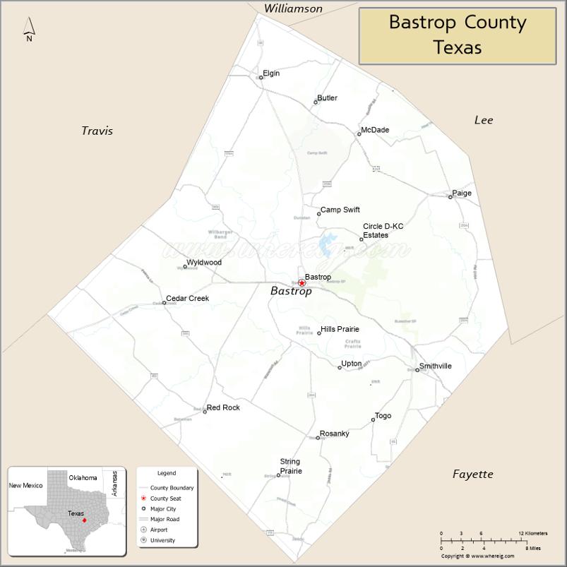
About Bastrop County Map, Texas: The map showing the county boundary, county seat, major cities, highways, water bodies and neighbouring counties.
Related Texas Maps
Map of Bastrop County, Texas
Bastrop County is a county located in the U.S. state of Texas. It's county seat is Bastrop. As per 2020 census, the population of Bastrop County is 102058 people and population density is square miles. According to the United States Census Bureau, the county has a total area of 888 sq mi (2,300 km2). Bastrop County was established on 1836.
Facts about Bastrop County, Texas
| Country | United States |
| State | Texas |
| Region | Central Texas |
| County Seat | Bastrop |
| Named After | Felipe Enrique Neri, Baron de Bastrop |
| Established | 1836 |
| Organized | 1837 |
| Coordinates | 30.1105° N, 97.3153° W |
| Total Area | 896 sq mi |
| Land Area | 888 sq mi |
| Water Area | 8 sq mi |
| Population (2020) | 97,216 |
| Population Rank | Growing Central Texas county |
| Major City | Bastrop |
| Main Industries | Manufacturing, Agriculture, Tourism, Technology |
| Major Airport | Austin–Bergstrom International Airport (nearby) |
| Time Zone | Central Time (UTC−06:00) |
| Known For | Lost Pines Forest, Colorado River, Bastrop State Park |
| Website | https://www.co.bastrop.tx.us |
Top Attractions in Bastrop County, Texas
- Bastrop State Park – Pine forest trails, cabins, and scenic drives.
- Lost Pines Forest – Unique pine ecosystem great for hiking and wildlife viewing.
- Downtown Bastrop – Historic Main Street with shops, cafés, and river views.
- Colorado River Kayaking – Calm river routes perfect for paddling and fishing.
- Lake Bastrop – Boating, camping, and waterfront recreation.
- Smithville Historic District – Charming town known for film locations and antiques.
- Bastrop County Museum – Local history exhibits in a historic building.
- Buescher State Park – Quiet park with lakes, trails, and shaded campsites.
- McKinney Roughs Nature Park – Hiking, zip-lining, and nature programs.
- Fisherman’s Park – Riverfront park with walking paths and playgrounds.
Cities and Towns in Bastrop County, Texas
| Place | Type | Population (Census 2020) | Latitude & Longitude |
|---|---|---|---|
| Bastrop (county seat) | City | 9988 | 30.1105°N, 97.3153°W |
| Elgin | City | 9112 | 30.3497°N, 97.3703°W |
| Smithville | City | 3922 | 30.0085°N, 97.1594°W |
| Wyldwood | Census Designated Place (CDP) | 3694 | 30.1363°N, 97.4725°W |
| Circle D-KC Estates | Census Designated Place (CDP) | 2588 | 30.1889°N, 97.2864°W |
| Camp Swift | Census Designated Place (CDP) | 6926 | 30.1862°N, 97.3116°W |
| Cedar Creek | Census Designated Place (CDP) | 4388 | 30.0864°N, 97.4931°W |
| McDade | Census Designated Place (CDP) | 720 | 30.2827°N, 97.2367°W |
| Paige | Census Designated Place (CDP) | 1065 | 30.2216°N, 97.1144°W |
| Red Rock | Census Designated Place (CDP) | 1174 | 29.9878°N, 97.3567°W |
| Rockne | Unincorporated Community | N/A | 29.9581°N, 97.2133°W |
| Rosanky | Unincorporated Community | N/A | 29.9258°N, 97.3075°W |
| Kovar | Unincorporated Community | N/A | 29.8844°N, 97.1681°W |
| Watterson | Unincorporated Community | N/A | 30.1668°N, 97.2285°W |
What are Major Roads and Highways in Bastrop County
Major highways connect the county to nearby regions and cities.
- Texas State Highway 71 - west toward Austin and east toward La Grange and Columbus
- U.S. Highway 290 - northwest toward Austin and southeast toward Houston
- Texas State Highway 95 - north toward Taylor and south toward Gonzales
- Texas State Highway 21 - east toward Caldwell and west toward San Marcos region
- Farm to Market Road 969 - connects eastern Travis County and Bastrop
- Farm to Market Road 1209 - serves Bastrop and surrounding communities
- Farm to Market Road 535 - connects Rosanky, Red Rock, and Bastrop
- Farm to Market Road 1441 - serves northern Bastrop County communities
What are Neighboring Counties of Bastrop County
- Williamson County (north)
- Lee County (east)
- Fayette County (southeast)
- Caldwell County (south)
- Travis County (west)
Distance from Bastrop County to Nearby Cities
The following distances are measured by road (driving).
- Bastrop to Elgin (Bastrop County), Texas - 19 mi (31 km)
- Bastrop to Smithville (Bastrop County), Texas - 13 mi (21 km)
- Bastrop to Giddings (Lee County), Texas - 24 mi (39 km)
- Bastrop to Lockhart (Caldwell County), Texas - 28 mi (45 km)
- Bastrop to La Grange (Fayette County), Texas - 35 mi (56 km)
- Bastrop to Taylor (Williamson County), Texas - 36 mi (58 km)
- Bastrop to Austin (Travis County), Texas - 33 mi (53 km)
- Bastrop to Round Rock (Williamson County), Texas - 42 mi (68 km)
- Bastrop to Georgetown (Williamson County), Texas - 53 mi (85 km)
- Bastrop to San Marcos (Hays County), Texas - 47 mi (76 km)
- Bastrop to New Braunfels (Comal County), Texas - 67 mi (108 km)
- Bastrop to Bryan (Brazos County), Texas - 81 mi (130 km)
- Bastrop to College Station (Brazos County), Texas - 86 mi (138 km)
- Bastrop to Houston (Harris County), Texas - 124 mi (200 km)
- Bastrop to San Antonio (Bexar County), Texas - 95 mi (153 km)
Waterbodies in Bastrop County
Colorado River, Lake Bastrop, Lake Walter E. Long watershed, Piney Creek, Cedar Creek, Wilbarger Creek, Big Sandy Creek, Alum Creek, Walnut Creek, Dogwood Creek, Spring Branch, Yegua Creek watershed, Carrizo-Wilcox Aquifer recharge areas, Lost Pines wetlands, oxbow lakes, farm ponds, and seasonal streams
Best Golf Courses in Bastrop County, Texas
| Golf Course | Location | Latitude & Longitude |
|---|---|---|
| Pine Forest Golf Club | Bastrop | 30.1038°N, 97.2704°W |
| Colovista Golf Club | Bastrop | 29.9438°N, 97.2407°W |
| Wolfdancer Golf Club | Lost Pines (Cedar Creek area) | 30.1109°N, 97.2545°W |
Colleges and Universities in Bastrop County, Texas
| Institution Name | Type | Level | Notable For |
|---|---|---|---|
| Austin Community College - Elgin Campus | Public | Community College | Higher education hub for eastern Central Texas |
| Austin Community College - Bastrop Center | Public | Community College | Workforce and transfer programs |
| Texas State Technical College - East Williamson/Bastrop Service Area | Public | Technical College | Career and technical education |
References
- U.S. Census Bureau - Bastrop County QuickFacts
- Official Bastrop County Website
- City of Bastrop Official Website
- Austin Community College District
- Texas Department of Transportation
- Anderson County Map
- Andrews County Map
- Angelina County Map
- Aransas County Map
- Archer County Map
- Armstrong County Map
- Atascosa County Map
- Austin County Map
- Bailey County Map
- Bandera County Map
- Bastrop County Map
- Baylor County Map
- Bee County Map
- Bell County Map
- Bexar County Map
- Blanco County Map
- Borden County Map
- Bosque County Map
- Bowie County Map
- Brazoria County Map
- Brazos County Map
- Brewster County Map
- Briscoe County Map
- Brooks County Map
- Brown County Map
- Burleson County Map
- Burnet County Map
- Caldwell County Map
- Calhoun County Map
- Callahan County Map
- Cameron County Map
- Camp County Map
- Carson County Map
- Cass County Map
- Castro County Map
- Chambers County Map
- Cherokee County Map
- Childress County Map
- Clay County Map
- Cochran County Map
- Coke County Map
- Coleman County Map
- Collin County Map
- Collingsworth County Map
- Colorado County Map
- Comal County Map
- Comanche County Map
- Concho County Map
- Cooke County Map
- Coryell County Map
- Cottle County Map
- Crane County Map
- Crockett County Map
- Crosby County Map
- Culberson County Map
- Dallam County Map
- Dallas County Map
- Dawson County Map
- Deaf Smith County Map
- Delta County Map
- Denton County Map
- DeWitt County Map
- Dickens County Map
- Dimmit County Map
- Donley County Map
- Duval County Map
- Eastland County Map
- Ector County Map
- Edwards County Map
- Ellis County Map
- El Paso County Map
- Erath County Map
- Falls County Map
- Fannin County Map
- Fayette County Map
- Fisher County Map
- Floyd County Map
- Foard County Map
- Fort Bend County Map
- Franklin County Map
- Freestone County Map
- Frio County Map
- Gaines County Map
- Galveston County Map
- Garza County Map
- Gillespie County Map
- Glasscock County Map
- Goliad County Map
- Gonzales County Map
- Gray County Map
- Grayson County Map
- Gregg County Map
- Grimes County Map
- Guadalupe County Map
- Hale County Map
- Hall County Map
- Hamilton County Map
- Hansford County Map
- Hardeman County Map
- Hardin County Map
- Harris County Map
- Harrison County Map
- Hartley County Map
- Haskell County Map
- Hays County Map
- Hemphill County Map
- Henderson County Map
- Hidalgo County Map
- Hill County Map
- Hockley County Map
- Hood County Map
- Hopkins County Map
- Houston County Map
- Howard County Map
- Hudspeth County Map
- Hunt County Map
- Hutchinson County Map
- Irion County Map
- Jack County Map
- Jackson County Map
- Jasper County Map
- Jeff Davis County Map
- Jefferson County Map
- Jim Hogg County Map
- Jim Wells County Map
- Johnson County Map
- Jones County Map
- Karnes County Map
- Kaufman County Map
- Kendall County Map
- Kenedy County Map
- Kent County Map
- Kerr County Map
- Kimble County Map
- King County Map
- Kinney County Map
- Kleberg County Map
- Knox County Map
- Lamar County Map
- Lamb County Map
- Lampasas County Map
- La Salle County Map
- Lavaca County Map
- Lee County Map
- Leon County Map
- Liberty County Map
- Limestone County Map
- Lipscomb County Map
- Live Oak County Map
- Llano County Map
- Loving County Map
- Lubbock County Map
- Lynn County Map
- McCulloch County Map
- McLennan County Map
- McMullen County Map
- Madison County Map
- Marion County Map
- Martin County Map
- Mason County Map
- Matagorda County Map
- Maverick County Map
- Medina County Map
- Menard County Map
- Midland County Map
- Milam County Map
- Mills County Map
- Mitchell County Map
- Montague County Map
- Montgomery County Map
- Moore County Map
- Morris County Map
- Motley County Map
- Nacogdoches County Map
- Navarro County Map
- Newton County Map
- Nolan County Map
- Nueces County Map
- Ochiltree County Map
- Oldham County Map
- Orange County Map
- Palo Pinto County Map
- Panola County Map
- Parker County Map
- Parmer County Map
- Pecos County Map
- Polk County Map
- Potter County Map
- Presidio County Map
- Rains County Map
- Randall County Map
- Reagan County Map
- Real County Map
- Red River County Map
- Reeves County Map
- Refugio County Map
- Roberts County Map
- Robertson County Map
- Rockwall County Map
- Runnels County Map
- Rusk County Map
- Sabine County Map
- San Augustine County Map
- San Jacinto County Map
- San Patricio County Map
- San Saba County Map
- Schleicher County Map
- Scurry County Map
- Shackelford County Map
- Shelby County Map
- Sherman County Map
- Smith County Map
- Somervell County Map
- Starr County Map
- Stephens County Map
- Sterling County Map
- Stonewall County Map
- Sutton County Map
- Swisher County Map
- Tarrant County Map
- Taylor County Map
- Terrell County Map
- Terry County Map
- Throckmorton County Map
- Titus County Map
- Tom Green County Map
- Travis County Map
- Trinity County Map
- Tyler County Map
- Upshur County Map
- Upton County Map
- Uvalde County Map
- Val Verde County Map
- Van Zandt County Map
- Victoria County Map
- Walker County Map
- Waller County Map
- Ward County Map
- Washington County Map
- Webb County Map
- Wharton County Map
- Wheeler County Map
- Wichita County Map
- Wilbarger County Map
- Willacy County Map
- Williamson County Map
- Wilson County Map
- Winkler County Map
- Wise County Map
- Wood County Map
- Yoakum County Map
- Young County Map
- Zapata County Map
- Zavala County Map
- Alabama Counties
- Alaska boroughs
- Arizona Counties
- Arkansas Counties
- California County Map
- Colorado Counties
- Connecticut Counties
- Delaware Counties
- Florida County Map
- Georgia County Map
- Hawaii Counties
- Idaho Counties
- Illinois Counties
- Indiana Counties
- Iowa Counties
- Kansas Counties
- Kentucky Counties
- Louisiana Counties
- Maine Counties
- Maryland Counties
- Massachusetts Counties
- Michigan County Map
- Minnesota Counties
- Mississippi Counties
- Missouri Counties
- Montana Counties
- Nebraska Counties
- Nevada Counties
- New York Counties
- New Hampshire Counties
- New Jersey Counties
- New Mexico Counties
- North Carolina Counties
- North Dakota Counties
- Ohio County Map
- Oklahoma Counties
- Oregon Counties
- Pennsylvania Counties
- Rhode Island Counties
- South Carolina Counties
- South Dakota Counties
- Map of Tennessee
- Texas County Map
- Utah Counties
- Vermont Counties
- Virginia Counties
- Washington Counties
- West Virginia Counties
- Wisconsin Counties
- Wyoming Counties
References
- ^ QuickFacts: Bastrop County, Texas - United States Census Bureau
- ^ United States Census Bureau - Population and Housing Data
- ^ TIGER/Line Shapefiles - United States Census Bureau
- ^ United States Geological Survey (USGS)
- ^ National Geodetic Survey (NGS), NOAA
- ^ Official Website of Bastrop County, Texas
- ^ Texas Department of Transportation (TxDOT)