Map of Cameron County - Cameron County is a county located in the U.S. state of Texas. Cameron County Map showing cities, highways, important places and water bodies. Get Where is Cameron County located in the map, major cities in Cameron county, population, areas, and places of interest.
Map of Cameron County, Texas
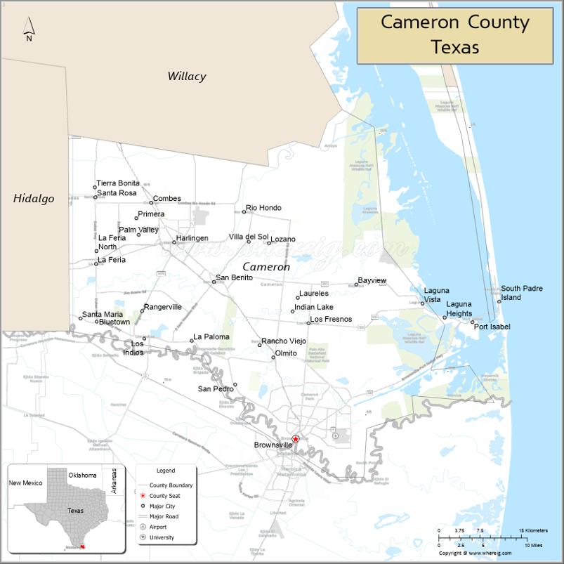
About Cameron County Map, Texas: The map showing the county boundary, county seat, major cities, highways, water bodies and neighbouring counties.
Related Texas Maps
Map of Cameron County, Texas
Cameron County is a county located in the U.S. state of Texas. It's county seat is Brownsville. As per 2020 census, the population of Cameron County is 423029 people and population density is square miles. According to the United States Census Bureau, the county has a total area of 906 sq mi (2,347 km2). Cameron County was established on 1848.
Facts about Cameron County, Texas
| Country | United States |
| State | Texas |
| Region | South Texas / Rio Grande Valley |
| County Seat | Brownsville |
| Named After | Ewen Cameron |
| Established | 1848 |
| Organized | 1848 |
| Coordinates | 25.9980° N, 97.4581° W |
| Total Area | 1,276 sq mi |
| Land Area | 891 sq mi |
| Water Area | 385 sq mi |
| Population (2020) | 421,017 |
| Population Rank | One of the largest counties in the Rio Grande Valley |
| Major Cities | Brownsville, Harlingen, San Benito |
| Main Industries | International Trade, Healthcare, Education, Aerospace (SpaceX), Tourism |
| Major Airport | Valley International Airport (Harlingen) |
| Time Zone | Central Time (UTC−06:00) |
| Known For | South Padre Island, SpaceX Starbase, Palo Alto Battlefield, Border culture |
| Website | https://www.cameroncounty.us |
Top Attractions in Cameron County, Texas
- South Padre Island – Beaches, water sports, and coastal recreation.
- Sea Turtle, Inc. – Sea turtle rescue center with educational exhibits.
- Port Isabel Lighthouse – Historic lighthouse offering panoramic views.
- Gladys Porter Zoo (Brownsville) – Popular zoo with global wildlife exhibits.
- Palo Alto Battlefield National Historical Park – Historic site from the U.S.–Mexican War.
- Boca Chica Beach – Remote beach known for quiet shorelines.
- SpaceX Starbase (Boca Chica) – Viewing area near rocket development and launches.
- Brownsville Museum of Fine Art – Regional and international art exhibitions.
- Resaca de la Palma State Park – Birding and nature trails in a tropical habitat.
- Dean Porter Park – Family park with playgrounds, walking paths, and gardens.
Cities and Towns in Cameron County, Texas
| Place | Type | Population (Census 2020) | Latitude & Longitude |
|---|---|---|---|
| Brownsville (county seat) | City | 186738 | 25.9017°N, 97.4975°W |
| Harlingen | City | 71492 | 26.1906°N, 97.6961°W |
| San Benito | City | 24690 | 26.1326°N, 97.6311°W |
| Los Fresnos | City | 8547 | 26.0717°N, 97.4764°W |
| La Feria | City | 7302 | 26.1587°N, 97.8242°W |
| Rio Hondo | City | 2356 | 26.2359°N, 97.5819°W |
| Combes | City | 2895 | 26.2484°N, 97.7333°W |
| Bayview | Town | 383 | 26.1297°N, 97.3994°W |
| Laguna Vista | Town | 3276 | 26.1048°N, 97.2900°W |
| Rancho Viejo | Town | 1766 | 26.0398°N, 97.5561°W |
| South Padre Island | Town | 2870 | 26.1118°N, 97.1681°W |
| Port Isabel | City | 5006 | 26.0734°N, 97.2086°W |
| Cameron Park | Census Designated Place (CDP) | 6099 | 25.9710°N, 97.4787°W |
| Olmito | Census Designated Place (CDP) | 1021 | 26.0142°N, 97.5344°W |
| Bluetown | Census Designated Place (CDP) | 491 | 26.0904°N, 97.6270°W |
| Indian Lake | Village | 640 | 26.0716°N, 97.4850°W |
| Santa Rosa | City | 2873 | 26.2567°N, 97.8258°W |
| Palm Valley | City | 1325 | 26.2550°N, 97.5519°W |
| Villa Nueva | Unincorporated Community | N/A | 26.1121°N, 97.5653°W |
| El Ranchito | Unincorporated Community | N/A | 26.0017°N, 97.5622°W |
What are Major Roads and Highways in Cameron County
Major highways connect the county to nearby regions and cities.
- Interstate 69E / U.S. Highway 77 - north toward Corpus Christi and south toward Brownsville
- Interstate 2 / U.S. Highway 83 - west toward McAllen and east toward Harlingen
- U.S. Highway 281 - connects Brownsville with Los Indios and Hidalgo County
- State Highway 48 - Brownsville to Port of Brownsville and Boca Chica area
- State Highway 100 - connects Port Isabel and South Padre Island with the mainland
- State Highway 4 - links Brownsville to Boca Chica Beach and Starbase
- Farm to Market Road 510 - serves Bayview and Laguna Vista
- Farm to Market Road 106 - connects Rio Hondo and surrounding agricultural areas
What are Neighboring Counties of Cameron County
- Willacy County (north)
- Hidalgo County (west)
- Gulf of Mexico (east)
- Mexico - Tamaulipas (south)
Distance from Cameron County to Nearby Cities
The following distances are measured by road (driving).
- Brownsville to Harlingen (Cameron County), Texas - 25 mi (40 km)
- Brownsville to San Benito (Cameron County), Texas - 8 mi (13 km)
- Brownsville to Los Fresnos (Cameron County), Texas - 12 mi (19 km)
- Brownsville to Port Isabel (Cameron County), Texas - 24 mi (39 km)
- Brownsville to South Padre Island (Cameron County), Texas - 29 mi (47 km)
- Brownsville to Rio Hondo (Cameron County), Texas - 28 mi (45 km)
- Brownsville to Raymondville (Willacy County), Texas - 53 mi (85 km)
- Brownsville to Weslaco (Hidalgo County), Texas - 38 mi (61 km)
- Brownsville to McAllen (Hidalgo County), Texas - 60 mi (97 km)
- Brownsville to Edinburg (Hidalgo County), Texas - 63 mi (101 km)
- Brownsville to Mission (Hidalgo County), Texas - 68 mi (109 km)
- Brownsville to Rio Grande City (Starr County), Texas - 82 mi (132 km)
- Brownsville to Kingsville (Kleberg County), Texas - 120 mi (193 km)
- Brownsville to Corpus Christi (Nueces County), Texas - 161 mi (259 km)
- Brownsville to Laredo (Webb County), Texas - 203 mi (327 km)
Waterbodies in Cameron County
Rio Grande, Gulf of Mexico, Laguna Madre, South Bay, Brazos Santiago Pass, Resaca de la Palma, Arroyo Colorado, Bahia Grande, Laguna Atascosa, South Padre Island tidal flats, Brownsville Ship Channel, Port of Brownsville waterways, coastal marshes, estuaries, wetlands, resacas, lagoons, and tidal inlets
Best Golf Courses in Cameron County, Texas
| Golf Course | Location | Latitude & Longitude |
|---|---|---|
| River Bend Resort & Golf Club | Brownsville | 25.9319°N, 97.4636°W |
| Brownsville Golf Center | Brownsville | 25.9513°N, 97.4865°W |
| Rancho Viejo Resort & Country Club - El Diablo Course | Rancho Viejo | 26.0369°N, 97.5641°W |
| Rancho Viejo Resort & Country Club - El Angel Course | Rancho Viejo | 26.0374°N, 97.5615°W |
| Tony Butler Golf Course | Harlingen | 26.1749°N, 97.6995°W |
| Treasure Hills Golf Club | Harlingen | 26.2118°N, 97.7078°W |
| South Padre Island Golf Club | Laguna Vista | 26.0975°N, 97.3247°W |
Colleges and Universities in Cameron County, Texas
| Institution Name | Type | Level | Notable For |
|---|---|---|---|
| The University of Texas Rio Grande Valley | Public | University | Major public research university serving the Rio Grande Valley |
| Texas Southmost College | Public | Community College | Academic transfer and workforce programs |
| Texas State Technical College - Harlingen | Public | Community College | Technical and career education |
| Southern Careers Institute - Harlingen | Private | College | Career-focused training programs |
References
- U.S. Census Bureau - Cameron County QuickFacts
- Official Cameron County Website
- Texas State Historical Association - Cameron County
- The University of Texas Rio Grande Valley
- Texas Southmost College
- Anderson County Map
- Andrews County Map
- Angelina County Map
- Aransas County Map
- Archer County Map
- Armstrong County Map
- Atascosa County Map
- Austin County Map
- Bailey County Map
- Bandera County Map
- Bastrop County Map
- Baylor County Map
- Bee County Map
- Bell County Map
- Bexar County Map
- Blanco County Map
- Borden County Map
- Bosque County Map
- Bowie County Map
- Brazoria County Map
- Brazos County Map
- Brewster County Map
- Briscoe County Map
- Brooks County Map
- Brown County Map
- Burleson County Map
- Burnet County Map
- Caldwell County Map
- Calhoun County Map
- Callahan County Map
- Cameron County Map
- Camp County Map
- Carson County Map
- Cass County Map
- Castro County Map
- Chambers County Map
- Cherokee County Map
- Childress County Map
- Clay County Map
- Cochran County Map
- Coke County Map
- Coleman County Map
- Collin County Map
- Collingsworth County Map
- Colorado County Map
- Comal County Map
- Comanche County Map
- Concho County Map
- Cooke County Map
- Coryell County Map
- Cottle County Map
- Crane County Map
- Crockett County Map
- Crosby County Map
- Culberson County Map
- Dallam County Map
- Dallas County Map
- Dawson County Map
- Deaf Smith County Map
- Delta County Map
- Denton County Map
- DeWitt County Map
- Dickens County Map
- Dimmit County Map
- Donley County Map
- Duval County Map
- Eastland County Map
- Ector County Map
- Edwards County Map
- Ellis County Map
- El Paso County Map
- Erath County Map
- Falls County Map
- Fannin County Map
- Fayette County Map
- Fisher County Map
- Floyd County Map
- Foard County Map
- Fort Bend County Map
- Franklin County Map
- Freestone County Map
- Frio County Map
- Gaines County Map
- Galveston County Map
- Garza County Map
- Gillespie County Map
- Glasscock County Map
- Goliad County Map
- Gonzales County Map
- Gray County Map
- Grayson County Map
- Gregg County Map
- Grimes County Map
- Guadalupe County Map
- Hale County Map
- Hall County Map
- Hamilton County Map
- Hansford County Map
- Hardeman County Map
- Hardin County Map
- Harris County Map
- Harrison County Map
- Hartley County Map
- Haskell County Map
- Hays County Map
- Hemphill County Map
- Henderson County Map
- Hidalgo County Map
- Hill County Map
- Hockley County Map
- Hood County Map
- Hopkins County Map
- Houston County Map
- Howard County Map
- Hudspeth County Map
- Hunt County Map
- Hutchinson County Map
- Irion County Map
- Jack County Map
- Jackson County Map
- Jasper County Map
- Jeff Davis County Map
- Jefferson County Map
- Jim Hogg County Map
- Jim Wells County Map
- Johnson County Map
- Jones County Map
- Karnes County Map
- Kaufman County Map
- Kendall County Map
- Kenedy County Map
- Kent County Map
- Kerr County Map
- Kimble County Map
- King County Map
- Kinney County Map
- Kleberg County Map
- Knox County Map
- Lamar County Map
- Lamb County Map
- Lampasas County Map
- La Salle County Map
- Lavaca County Map
- Lee County Map
- Leon County Map
- Liberty County Map
- Limestone County Map
- Lipscomb County Map
- Live Oak County Map
- Llano County Map
- Loving County Map
- Lubbock County Map
- Lynn County Map
- McCulloch County Map
- McLennan County Map
- McMullen County Map
- Madison County Map
- Marion County Map
- Martin County Map
- Mason County Map
- Matagorda County Map
- Maverick County Map
- Medina County Map
- Menard County Map
- Midland County Map
- Milam County Map
- Mills County Map
- Mitchell County Map
- Montague County Map
- Montgomery County Map
- Moore County Map
- Morris County Map
- Motley County Map
- Nacogdoches County Map
- Navarro County Map
- Newton County Map
- Nolan County Map
- Nueces County Map
- Ochiltree County Map
- Oldham County Map
- Orange County Map
- Palo Pinto County Map
- Panola County Map
- Parker County Map
- Parmer County Map
- Pecos County Map
- Polk County Map
- Potter County Map
- Presidio County Map
- Rains County Map
- Randall County Map
- Reagan County Map
- Real County Map
- Red River County Map
- Reeves County Map
- Refugio County Map
- Roberts County Map
- Robertson County Map
- Rockwall County Map
- Runnels County Map
- Rusk County Map
- Sabine County Map
- San Augustine County Map
- San Jacinto County Map
- San Patricio County Map
- San Saba County Map
- Schleicher County Map
- Scurry County Map
- Shackelford County Map
- Shelby County Map
- Sherman County Map
- Smith County Map
- Somervell County Map
- Starr County Map
- Stephens County Map
- Sterling County Map
- Stonewall County Map
- Sutton County Map
- Swisher County Map
- Tarrant County Map
- Taylor County Map
- Terrell County Map
- Terry County Map
- Throckmorton County Map
- Titus County Map
- Tom Green County Map
- Travis County Map
- Trinity County Map
- Tyler County Map
- Upshur County Map
- Upton County Map
- Uvalde County Map
- Val Verde County Map
- Van Zandt County Map
- Victoria County Map
- Walker County Map
- Waller County Map
- Ward County Map
- Washington County Map
- Webb County Map
- Wharton County Map
- Wheeler County Map
- Wichita County Map
- Wilbarger County Map
- Willacy County Map
- Williamson County Map
- Wilson County Map
- Winkler County Map
- Wise County Map
- Wood County Map
- Yoakum County Map
- Young County Map
- Zapata County Map
- Zavala County Map
- Alabama Counties
- Alaska boroughs
- Arizona Counties
- Arkansas Counties
- California County Map
- Colorado Counties
- Connecticut Counties
- Delaware Counties
- Florida County Map
- Georgia County Map
- Hawaii Counties
- Idaho Counties
- Illinois Counties
- Indiana Counties
- Iowa Counties
- Kansas Counties
- Kentucky Counties
- Louisiana Counties
- Maine Counties
- Maryland Counties
- Massachusetts Counties
- Michigan County Map
- Minnesota Counties
- Mississippi Counties
- Missouri Counties
- Montana Counties
- Nebraska Counties
- Nevada Counties
- New York Counties
- New Hampshire Counties
- New Jersey Counties
- New Mexico Counties
- North Carolina Counties
- North Dakota Counties
- Ohio County Map
- Oklahoma Counties
- Oregon Counties
- Pennsylvania Counties
- Rhode Island Counties
- South Carolina Counties
- South Dakota Counties
- Map of Tennessee
- Texas County Map
- Utah Counties
- Vermont Counties
- Virginia Counties
- Washington Counties
- West Virginia Counties
- Wisconsin Counties
- Wyoming Counties
References
- ^ QuickFacts: Cameron County, Texas - United States Census Bureau
- ^ United States Census Bureau - Population and Housing Data
- ^ TIGER/Line Shapefiles - United States Census Bureau
- ^ United States Geological Survey (USGS)
- ^ National Geodetic Survey (NGS), NOAA
- ^ Official Website of Cameron County, Texas
- ^ Texas Department of Transportation (TxDOT)