Map of Terrell County - Terrell County is a county located in the U.S. state of Texas. Terrell County Map showing cities, highways, important places and water bodies. Get Where is Terrell County located in the map, major cities in Terrell county, population, areas, and places of interest.
Map of Terrell County, Texas
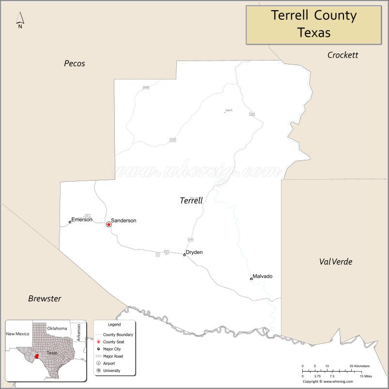
About Terrell County Map, Texas: The map showing the county boundary, county seat, major cities, highways, water bodies and neighbouring counties.
Related Texas Maps
Map of Terrell County, Texas
Terrell County is a county located in the U.S. state of Texas. It's county seat is Sanderson. As per 2020 census, the population of Terrell County is 724 people and population density is square miles. According to the United States Census Bureau, the county has a total area of 2,358 sq mi (6,107 km2). Terrell County was established on 1905.
Facts about Terrell County, Texas
| Country | United States |
| State | Texas |
| Region | West Texas / Trans-Pecos |
| County Seat | Sanderson |
| Named After | Alexander Watkins Terrell, Texas politician and diplomat |
| Established | 1905 |
| Organized | 1905 |
| Coordinates | 30.2240° N, 102.0760° W |
| Total Area | 2,358 sq mi |
| Land Area | 2,358 sq mi |
| Water Area | <1 sq mi |
| Population (2020) | 741 |
| Population Rank | One of the least populated counties in Texas |
| Major City | Sanderson |
| Main Industries | Ranching, Agriculture, Hunting, Transportation |
| Major Airport | Sanderson Airport (local) |
| Time Zone | Central Time (UTC−06:00) |
| Known For | Desert landscapes, Ranching heritage, Quiet West Texas lifestyle |
| Website | https://www.co.terrell.tx.us |
Top Attractions in Terrell County, Texas
- Sanderson Downtown Area – Small-town shops and local charm.
- Terrell County Courthouse – Historic courthouse landmark.
- Pecos River Overlook – Scenic canyon and river views.
- Sanderson Canyon Rim – Rugged desert scenery.
- Judge Roy Bean Visitor Center (nearby) – Old West history site.
- Local Desert Ranchlands – Wide-open West Texas landscapes.
- Highway 90 Scenic Drive – Remote desert vistas.
- Historic Railroad Sites – Early rail history markers.
- Wildlife Viewing Areas – Deer and desert species.
- Clear Night Skies – Stargazing opportunities.
Cities and Towns in Terrell County, Texas
| Place | Type | Population (Census 2020) | Latitude & Longitude |
|---|---|---|---|
| Sanderson (county seat) | Census Designated Place (CDP) | 837 | 30.1427°N, 102.3940°W |
| Dryden | Unincorporated Community | N/A | 30.0449°N, 102.1137°W |
| Lobo | Unincorporated Community | N/A | 30.2210°N, 102.8210°W |
| Pumpville | Unincorporated Community | N/A | 29.8035°N, 101.5663°W |
What are Major Roads and Highways in Terrell County
Major highways connect the county to nearby regions and cities.
- Interstate 10 - major east-west corridor connecting Sanderson with Van Horn, Fort Stockton, San Antonio, and El Paso
- U.S. Highway 90 - historic route connecting Sanderson with Del Rio, Alpine, and West Texas communities
- State Highway 349 - north-south route connecting Terrell County with Sheffield, Midland, and West Texas oil-producing regions
- Farm to Market Road 2400 - serves ranching operations and remote communities
- Ranch to Market Road 192 - provides access to southern portions of the county near the Rio Grande
What are Neighboring Counties of Terrell County
- Pecos County (north)
- Val Verde County (east)
- Brewster County (west)
- Edwards County (northeast - corner boundary)
Distance from Terrell County to Nearby Cities
The following distances are measured by road (driving).
- Sanderson to Dryden (Terrell County), Texas - 18 mi (29 km)
- Sanderson to Sheffield (Pecos County), Texas - 54 mi (87 km)
- Sanderson to Del Rio (Val Verde County), Texas - 118 mi (190 km)
- Sanderson to Alpine (Brewster County), Texas - 82 mi (132 km)
- Sanderson to Fort Stockton (Pecos County), Texas - 117 mi (188 km)
- Sanderson to Marathon (Brewster County), Texas - 56 mi (90 km)
- Sanderson to Ozona (Crockett County), Texas - 117 mi (188 km)
- Sanderson to Sonora (Sutton County), Texas - 171 mi (275 km)
- Sanderson to Eagle Pass (Maverick County), Texas - 165 mi (266 km)
- Sanderson to Midland (Midland County), Texas - 236 mi (380 km)
- Sanderson to Odessa (Ector County), Texas - 245 mi (394 km)
- Sanderson to San Angelo (Tom Green County), Texas - 258 mi (415 km)
- Sanderson to El Paso (El Paso County), Texas - 310 mi (499 km)
- Sanderson to San Antonio (Bexar County), Texas - 303 mi (488 km)
- Sanderson to Austin (Travis County), Texas - 360 mi (579 km)
Waterbodies in Terrell County
Rio Grande, Pecos River, Independence Creek, Sanderson Canyon, Dryden Draw, Howard Draw, Live Oak Creek, Seven Mile Draw, Reagan Canyon, Devil's River Watershed Tributaries, Independence Creek Preserve Springs, Lower Pecos River Basin, Black Canyon, Cedar Creek
Best Golf Courses in Terrell County, Texas
| Golf Course | Location | Latitude & Longitude |
|---|---|---|
| Terrell County Golf Course | Sanderson | 30.1461°N, 102.3925°W |
Colleges and Universities in Terrell County, Texas
| Institution Name | Type (Public/Private) | Level | Notable For |
|---|---|---|---|
| Sul Ross State University | Public | University | Nearest public university in Alpine |
| Sul Ross State University - Rio Grande College | Public | University | Distance learning and regional programs |
| Southwest Texas Junior College | Public | Community College | Regional community college serving Southwest Texas |
| Midland College | Public | Community College | Higher education access for West Texas residents |
| Angelo State University | Public | University | Regional university serving West Texas |
References
- U.S. Census Bureau - 2020 Census Data for Terrell County and Sanderson
- U.S. Census Bureau QuickFacts - Terrell County
- Texas State Historical Association - Terrell County
- Official Terrell County Website
- USGS Geographic Names Information System (GNIS)
- Anderson County Map
- Andrews County Map
- Angelina County Map
- Aransas County Map
- Archer County Map
- Armstrong County Map
- Atascosa County Map
- Austin County Map
- Bailey County Map
- Bandera County Map
- Bastrop County Map
- Baylor County Map
- Bee County Map
- Bell County Map
- Bexar County Map
- Blanco County Map
- Borden County Map
- Bosque County Map
- Bowie County Map
- Brazoria County Map
- Brazos County Map
- Brewster County Map
- Briscoe County Map
- Brooks County Map
- Brown County Map
- Burleson County Map
- Burnet County Map
- Caldwell County Map
- Calhoun County Map
- Callahan County Map
- Cameron County Map
- Camp County Map
- Carson County Map
- Cass County Map
- Castro County Map
- Chambers County Map
- Cherokee County Map
- Childress County Map
- Clay County Map
- Cochran County Map
- Coke County Map
- Coleman County Map
- Collin County Map
- Collingsworth County Map
- Colorado County Map
- Comal County Map
- Comanche County Map
- Concho County Map
- Cooke County Map
- Coryell County Map
- Cottle County Map
- Crane County Map
- Crockett County Map
- Crosby County Map
- Culberson County Map
- Dallam County Map
- Dallas County Map
- Dawson County Map
- Deaf Smith County Map
- Delta County Map
- Denton County Map
- DeWitt County Map
- Dickens County Map
- Dimmit County Map
- Donley County Map
- Duval County Map
- Eastland County Map
- Ector County Map
- Edwards County Map
- Ellis County Map
- El Paso County Map
- Erath County Map
- Falls County Map
- Fannin County Map
- Fayette County Map
- Fisher County Map
- Floyd County Map
- Foard County Map
- Fort Bend County Map
- Franklin County Map
- Freestone County Map
- Frio County Map
- Gaines County Map
- Galveston County Map
- Garza County Map
- Gillespie County Map
- Glasscock County Map
- Goliad County Map
- Gonzales County Map
- Gray County Map
- Grayson County Map
- Gregg County Map
- Grimes County Map
- Guadalupe County Map
- Hale County Map
- Hall County Map
- Hamilton County Map
- Hansford County Map
- Hardeman County Map
- Hardin County Map
- Harris County Map
- Harrison County Map
- Hartley County Map
- Haskell County Map
- Hays County Map
- Hemphill County Map
- Henderson County Map
- Hidalgo County Map
- Hill County Map
- Hockley County Map
- Hood County Map
- Hopkins County Map
- Houston County Map
- Howard County Map
- Hudspeth County Map
- Hunt County Map
- Hutchinson County Map
- Irion County Map
- Jack County Map
- Jackson County Map
- Jasper County Map
- Jeff Davis County Map
- Jefferson County Map
- Jim Hogg County Map
- Jim Wells County Map
- Johnson County Map
- Jones County Map
- Karnes County Map
- Kaufman County Map
- Kendall County Map
- Kenedy County Map
- Kent County Map
- Kerr County Map
- Kimble County Map
- King County Map
- Kinney County Map
- Kleberg County Map
- Knox County Map
- Lamar County Map
- Lamb County Map
- Lampasas County Map
- La Salle County Map
- Lavaca County Map
- Lee County Map
- Leon County Map
- Liberty County Map
- Limestone County Map
- Lipscomb County Map
- Live Oak County Map
- Llano County Map
- Loving County Map
- Lubbock County Map
- Lynn County Map
- McCulloch County Map
- McLennan County Map
- McMullen County Map
- Madison County Map
- Marion County Map
- Martin County Map
- Mason County Map
- Matagorda County Map
- Maverick County Map
- Medina County Map
- Menard County Map
- Midland County Map
- Milam County Map
- Mills County Map
- Mitchell County Map
- Montague County Map
- Montgomery County Map
- Moore County Map
- Morris County Map
- Motley County Map
- Nacogdoches County Map
- Navarro County Map
- Newton County Map
- Nolan County Map
- Nueces County Map
- Ochiltree County Map
- Oldham County Map
- Orange County Map
- Palo Pinto County Map
- Panola County Map
- Parker County Map
- Parmer County Map
- Pecos County Map
- Polk County Map
- Potter County Map
- Presidio County Map
- Rains County Map
- Randall County Map
- Reagan County Map
- Real County Map
- Red River County Map
- Reeves County Map
- Refugio County Map
- Roberts County Map
- Robertson County Map
- Rockwall County Map
- Runnels County Map
- Rusk County Map
- Sabine County Map
- San Augustine County Map
- San Jacinto County Map
- San Patricio County Map
- San Saba County Map
- Schleicher County Map
- Scurry County Map
- Shackelford County Map
- Shelby County Map
- Sherman County Map
- Smith County Map
- Somervell County Map
- Starr County Map
- Stephens County Map
- Sterling County Map
- Stonewall County Map
- Sutton County Map
- Swisher County Map
- Tarrant County Map
- Taylor County Map
- Terrell County Map
- Terry County Map
- Throckmorton County Map
- Titus County Map
- Tom Green County Map
- Travis County Map
- Trinity County Map
- Tyler County Map
- Upshur County Map
- Upton County Map
- Uvalde County Map
- Val Verde County Map
- Van Zandt County Map
- Victoria County Map
- Walker County Map
- Waller County Map
- Ward County Map
- Washington County Map
- Webb County Map
- Wharton County Map
- Wheeler County Map
- Wichita County Map
- Wilbarger County Map
- Willacy County Map
- Williamson County Map
- Wilson County Map
- Winkler County Map
- Wise County Map
- Wood County Map
- Yoakum County Map
- Young County Map
- Zapata County Map
- Zavala County Map
- Alabama Counties
- Alaska boroughs
- Arizona Counties
- Arkansas Counties
- California County Map
- Colorado Counties
- Connecticut Counties
- Delaware Counties
- Florida County Map
- Georgia County Map
- Hawaii Counties
- Idaho Counties
- Illinois Counties
- Indiana Counties
- Iowa Counties
- Kansas Counties
- Kentucky Counties
- Louisiana Counties
- Maine Counties
- Maryland Counties
- Massachusetts Counties
- Michigan County Map
- Minnesota Counties
- Mississippi Counties
- Missouri Counties
- Montana Counties
- Nebraska Counties
- Nevada Counties
- New York Counties
- New Hampshire Counties
- New Jersey Counties
- New Mexico Counties
- North Carolina Counties
- North Dakota Counties
- Ohio County Map
- Oklahoma Counties
- Oregon Counties
- Pennsylvania Counties
- Rhode Island Counties
- South Carolina Counties
- South Dakota Counties
- Map of Tennessee
- Texas County Map
- Utah Counties
- Vermont Counties
- Virginia Counties
- Washington Counties
- West Virginia Counties
- Wisconsin Counties
- Wyoming Counties
References
- ^ QuickFacts: Terrell County, Texas - United States Census Bureau
- ^ United States Census Bureau - Population and Housing Data
- ^ TIGER/Line Shapefiles - United States Census Bureau
- ^ United States Geological Survey (USGS)
- ^ National Geodetic Survey (NGS), NOAA
- ^ Official Website of Terrell County, Texas
- ^ Texas Department of Transportation (TxDOT)