Map of Webb County - Webb County is a county located in the U.S. state of Texas. Webb County Map showing cities, highways, important places and water bodies. Get Where is Webb County located in the map, major cities in Webb county, population, areas, and places of interest.
Map of Webb County, Texas
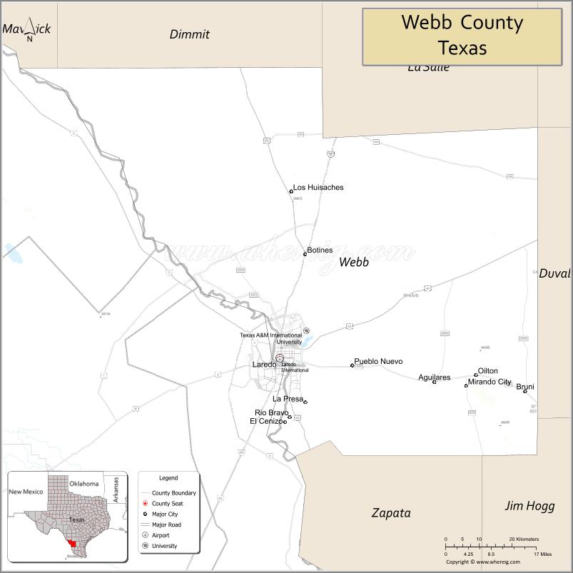
About Webb County Map, Texas: The map showing the county boundary, county seat, major cities, highways, water bodies and neighbouring counties.
Related Texas Maps
Map of Webb County, Texas
Webb County is a county located in the U.S. state of Texas. It's county seat is Laredo. As per 2020 census, the population of Webb County is 267945 people and population density is square miles. According to the United States Census Bureau, the county has a total area of 3,357 sq mi (8,695 km2). Webb County was established on 1848.
Facts about Webb County, Texas
| Country | United States |
| State | Texas |
| Region | South Texas / Rio Grande Border Region |
| County Seat | Laredo |
| Named After | James Webb, Secretary of the Treasury of the Republic of Texas |
| Established | 1848 |
| Organized | 1852 |
| Coordinates | 27.7610° N, 99.3310° W |
| Total Area | 3,376 sq mi |
| Land Area | 3,358 sq mi |
| Water Area | 18 sq mi |
| Population (2020) | 267,114 |
| Population Rank | One of the most populous counties in South Texas |
| Major City | Laredo |
| Main Industries | International Trade, Logistics, Government, Retail, Transportation |
| Major Airport | Laredo International Airport (LRD) |
| Time Zone | Central Time (UTC−06:00) |
| Known For | International trade hub, Port of Laredo, Border culture |
| Website | https://www.webbcountytx.gov |
Top Attractions in Webb County, Texas
- San Agustin Plaza – Historic downtown square in Laredo.
- Laredo Water Museum – History of water and utilities.
- Republic of the Rio Grande Museum – Borderlands history exhibits.
- Lake Casa Blanca International State Park – Fishing and picnicking.
- Laredo Center for the Arts – Local and regional art displays.
- Downtown Laredo Historic District – Architecture and culture.
- San Bernardo Avenue – Shops and border commerce.
- Fort McIntosh – Historic military post.
- Rio Grande Riverwalk Areas – Scenic river views.
- Webb County Courthouse – Historic courthouse landmark.
Cities and Towns in Webb County, Texas
| Place | Type | Population (Census 2020) | Latitude & Longitude |
|---|---|---|---|
| Laredo (county seat) | City | 257602 | 27.5306°N, 99.4803°W |
| El Cenizo | City | 3273 | 27.3348°N, 99.4925°W |
| Rio Bravo | City | 4942 | 27.3642°N, 99.4795°W |
| Aguilares | Census Designated Place (CDP) | 6 | 27.4516°N, 99.0932°W |
| Bonanza Hills | Census Designated Place (CDP) | 39 | 27.6748°N, 99.4828°W |
| Botines | Census Designated Place (CDP) | 117 | 27.7931°N, 99.2708°W |
| Bruni | Census Designated Place (CDP) | 379 | 27.4314°N, 98.8375°W |
| Colorado Acres | Census Designated Place (CDP) | 101 | 27.6370°N, 99.2945°W |
| Four Points | Census Designated Place (CDP) | 43 | 27.7462°N, 99.4062°W |
| Hillside Acres | Census Designated Place (CDP) | 21 | 27.6687°N, 99.5160°W |
| La Coma | Census Designated Place (CDP) | 198 | 27.6144°N, 99.4301°W |
| La Moca Ranch | Census Designated Place (CDP) | 174 | 27.6070°N, 99.3906°W |
| La Presa | Census Designated Place (CDP) | 241 | 27.5549°N, 99.3858°W |
| Laredo Ranchettes | Census Designated Place (CDP) | 1978 | 27.6268°N, 99.3411°W |
| Laredo Ranchettes West | Census Designated Place (CDP) | 120 | 27.6334°N, 99.3775°W |
| Las Haciendas | Census Designated Place (CDP) | 2 | 27.6164°N, 99.3640°W |
| Mirando City | Census Designated Place (CDP) | 456 | 27.4384°N, 99.0014°W |
| Oilton | Census Designated Place (CDP) | 270 | 27.4720°N, 98.9803°W |
| Pueblo Nuevo | Census Designated Place (CDP) | 488 | 27.5215°N, 99.4268°W |
| San Carlos I | Census Designated Place (CDP) | 231 | 27.5108°N, 99.3284°W |
| Mirando Valley | Unincorporated Community | N/A | 27.4100°N, 99.0500°W |
What are Major Roads and Highways in Webb County
Major highways connect the county to nearby regions and cities.
- Interstate 35 - major north-south corridor connecting Laredo with San Antonio, Austin, Dallas, and the U.S.-Mexico border
- Interstate 69W (U.S. Highway 59) - connects Laredo with Freer, George West, and Houston-area routes
- U.S. Highway 83 - links Laredo with Zapata, Rio Grande City, Carrizo Springs, and the Rio Grande Valley
- Loop 20 (Bob Bullock Loop) - major beltway around Laredo
- State Highway 255 (Mines Road Expressway) - provides access to industrial and international trade facilities
- Farm to Market Road 1472 (Mines Road) - serves northern Webb County and industrial developments
- Farm to Market Road 3338 - connects eastern portions of the county with Interstate 35
What are Neighboring Counties of Webb County
- Dimmit County (north)
- La Salle County (northeast)
- McMullen County (northeast)
- Duval County (east)
- Jim Hogg County (southeast)
- Zapata County (south)
Distance from Webb County to Nearby Cities
The following distances are measured by road (driving).
- Laredo to Rio Bravo (Webb County), Texas - 8 mi (13 km)
- Laredo to El Cenizo (Webb County), Texas - 10 mi (16 km)
- Laredo to Oilton (Webb County), Texas - 44 mi (71 km)
- Laredo to Mirando City (Webb County), Texas - 41 mi (66 km)
- Laredo to Zapata (Zapata County), Texas - 49 mi (79 km)
- Laredo to Freer (Duval County), Texas - 63 mi (101 km)
- Laredo to Hebbronville (Jim Hogg County), Texas - 47 mi (76 km)
- Laredo to Cotulla (La Salle County), Texas - 70 mi (113 km)
- Laredo to Carrizo Springs (Dimmit County), Texas - 91 mi (146 km)
- Laredo to Three Rivers (Live Oak County), Texas - 108 mi (174 km)
- Laredo to Alice (Jim Wells County), Texas - 109 mi (175 km)
- Laredo to Eagle Pass (Maverick County), Texas - 131 mi (211 km)
- Laredo to Corpus Christi (Nueces County), Texas - 144 mi (232 km)
- Laredo to San Antonio (Bexar County), Texas - 157 mi (253 km)
- Laredo to Austin (Travis County), Texas - 235 mi (378 km)
Waterbodies in Webb County
Rio Grande, Falcon International Reservoir, Chacon Creek, San Idelfonso Creek, Zacate Creek, Pinto Creek, Las Raices Creek, Cuervo Creek, Sombrerito Creek, Salado Creek, Dolores Creek, Bravo Creek, Rio Grande Watershed, Falcon Reservoir Tributaries
Best Golf Courses in Webb County, Texas
| Golf Course | Location | Latitude & Longitude |
|---|---|---|
| Laredo Country Club | Laredo | 27.5736°N, 99.4673°W |
| The MAX A Mandel Municipal Golf Course | Laredo | 27.5502°N, 99.4555°W |
| Laredo Municipal Golf Course | Laredo | 27.5278°N, 99.4898°W |
Colleges and Universities in Webb County, Texas
| Institution Name | Type (Public/Private) | Level | Notable For |
|---|---|---|---|
| Texas A&M International University | Public | University | International business and border studies programs |
| Laredo College | Public | Community College | Main higher education institution serving Webb County |
| University of Texas Health Science Center at San Antonio - Laredo Campus | Public | University | Health sciences and medical education |
| South Texas College of Law Outreach Programs | Public | University | Legal education partnerships and outreach |
| Texas A&M International University Graduate School | Public | University | Graduate and professional degree programs |
References
- U.S. Census Bureau QuickFacts - Webb County
- Official Webb County Website
- Texas A&M International University
- Texas State Historical Association - Webb County
- USGS Geographic Names Information System (GNIS)
- Anderson County Map
- Andrews County Map
- Angelina County Map
- Aransas County Map
- Archer County Map
- Armstrong County Map
- Atascosa County Map
- Austin County Map
- Bailey County Map
- Bandera County Map
- Bastrop County Map
- Baylor County Map
- Bee County Map
- Bell County Map
- Bexar County Map
- Blanco County Map
- Borden County Map
- Bosque County Map
- Bowie County Map
- Brazoria County Map
- Brazos County Map
- Brewster County Map
- Briscoe County Map
- Brooks County Map
- Brown County Map
- Burleson County Map
- Burnet County Map
- Caldwell County Map
- Calhoun County Map
- Callahan County Map
- Cameron County Map
- Camp County Map
- Carson County Map
- Cass County Map
- Castro County Map
- Chambers County Map
- Cherokee County Map
- Childress County Map
- Clay County Map
- Cochran County Map
- Coke County Map
- Coleman County Map
- Collin County Map
- Collingsworth County Map
- Colorado County Map
- Comal County Map
- Comanche County Map
- Concho County Map
- Cooke County Map
- Coryell County Map
- Cottle County Map
- Crane County Map
- Crockett County Map
- Crosby County Map
- Culberson County Map
- Dallam County Map
- Dallas County Map
- Dawson County Map
- Deaf Smith County Map
- Delta County Map
- Denton County Map
- DeWitt County Map
- Dickens County Map
- Dimmit County Map
- Donley County Map
- Duval County Map
- Eastland County Map
- Ector County Map
- Edwards County Map
- Ellis County Map
- El Paso County Map
- Erath County Map
- Falls County Map
- Fannin County Map
- Fayette County Map
- Fisher County Map
- Floyd County Map
- Foard County Map
- Fort Bend County Map
- Franklin County Map
- Freestone County Map
- Frio County Map
- Gaines County Map
- Galveston County Map
- Garza County Map
- Gillespie County Map
- Glasscock County Map
- Goliad County Map
- Gonzales County Map
- Gray County Map
- Grayson County Map
- Gregg County Map
- Grimes County Map
- Guadalupe County Map
- Hale County Map
- Hall County Map
- Hamilton County Map
- Hansford County Map
- Hardeman County Map
- Hardin County Map
- Harris County Map
- Harrison County Map
- Hartley County Map
- Haskell County Map
- Hays County Map
- Hemphill County Map
- Henderson County Map
- Hidalgo County Map
- Hill County Map
- Hockley County Map
- Hood County Map
- Hopkins County Map
- Houston County Map
- Howard County Map
- Hudspeth County Map
- Hunt County Map
- Hutchinson County Map
- Irion County Map
- Jack County Map
- Jackson County Map
- Jasper County Map
- Jeff Davis County Map
- Jefferson County Map
- Jim Hogg County Map
- Jim Wells County Map
- Johnson County Map
- Jones County Map
- Karnes County Map
- Kaufman County Map
- Kendall County Map
- Kenedy County Map
- Kent County Map
- Kerr County Map
- Kimble County Map
- King County Map
- Kinney County Map
- Kleberg County Map
- Knox County Map
- Lamar County Map
- Lamb County Map
- Lampasas County Map
- La Salle County Map
- Lavaca County Map
- Lee County Map
- Leon County Map
- Liberty County Map
- Limestone County Map
- Lipscomb County Map
- Live Oak County Map
- Llano County Map
- Loving County Map
- Lubbock County Map
- Lynn County Map
- McCulloch County Map
- McLennan County Map
- McMullen County Map
- Madison County Map
- Marion County Map
- Martin County Map
- Mason County Map
- Matagorda County Map
- Maverick County Map
- Medina County Map
- Menard County Map
- Midland County Map
- Milam County Map
- Mills County Map
- Mitchell County Map
- Montague County Map
- Montgomery County Map
- Moore County Map
- Morris County Map
- Motley County Map
- Nacogdoches County Map
- Navarro County Map
- Newton County Map
- Nolan County Map
- Nueces County Map
- Ochiltree County Map
- Oldham County Map
- Orange County Map
- Palo Pinto County Map
- Panola County Map
- Parker County Map
- Parmer County Map
- Pecos County Map
- Polk County Map
- Potter County Map
- Presidio County Map
- Rains County Map
- Randall County Map
- Reagan County Map
- Real County Map
- Red River County Map
- Reeves County Map
- Refugio County Map
- Roberts County Map
- Robertson County Map
- Rockwall County Map
- Runnels County Map
- Rusk County Map
- Sabine County Map
- San Augustine County Map
- San Jacinto County Map
- San Patricio County Map
- San Saba County Map
- Schleicher County Map
- Scurry County Map
- Shackelford County Map
- Shelby County Map
- Sherman County Map
- Smith County Map
- Somervell County Map
- Starr County Map
- Stephens County Map
- Sterling County Map
- Stonewall County Map
- Sutton County Map
- Swisher County Map
- Tarrant County Map
- Taylor County Map
- Terrell County Map
- Terry County Map
- Throckmorton County Map
- Titus County Map
- Tom Green County Map
- Travis County Map
- Trinity County Map
- Tyler County Map
- Upshur County Map
- Upton County Map
- Uvalde County Map
- Val Verde County Map
- Van Zandt County Map
- Victoria County Map
- Walker County Map
- Waller County Map
- Ward County Map
- Washington County Map
- Webb County Map
- Wharton County Map
- Wheeler County Map
- Wichita County Map
- Wilbarger County Map
- Willacy County Map
- Williamson County Map
- Wilson County Map
- Winkler County Map
- Wise County Map
- Wood County Map
- Yoakum County Map
- Young County Map
- Zapata County Map
- Zavala County Map
- Alabama Counties
- Alaska boroughs
- Arizona Counties
- Arkansas Counties
- California County Map
- Colorado Counties
- Connecticut Counties
- Delaware Counties
- Florida County Map
- Georgia County Map
- Hawaii Counties
- Idaho Counties
- Illinois Counties
- Indiana Counties
- Iowa Counties
- Kansas Counties
- Kentucky Counties
- Louisiana Counties
- Maine Counties
- Maryland Counties
- Massachusetts Counties
- Michigan County Map
- Minnesota Counties
- Mississippi Counties
- Missouri Counties
- Montana Counties
- Nebraska Counties
- Nevada Counties
- New York Counties
- New Hampshire Counties
- New Jersey Counties
- New Mexico Counties
- North Carolina Counties
- North Dakota Counties
- Ohio County Map
- Oklahoma Counties
- Oregon Counties
- Pennsylvania Counties
- Rhode Island Counties
- South Carolina Counties
- South Dakota Counties
- Map of Tennessee
- Texas County Map
- Utah Counties
- Vermont Counties
- Virginia Counties
- Washington Counties
- West Virginia Counties
- Wisconsin Counties
- Wyoming Counties
References
- ^ QuickFacts: Webb County, Texas - United States Census Bureau
- ^ United States Census Bureau - Population and Housing Data
- ^ TIGER/Line Shapefiles - United States Census Bureau
- ^ United States Geological Survey (USGS)
- ^ National Geodetic Survey (NGS), NOAA
- ^ Official Website of Webb County, Texas
- ^ Texas Department of Transportation (TxDOT)