Map of Victoria County - Victoria County is a county located in the U.S. state of Texas. Victoria County Map showing cities, highways, important places and water bodies. Get Where is Victoria County located in the map, major cities in Victoria county, population, areas, and places of interest.
Map of Victoria County, Texas
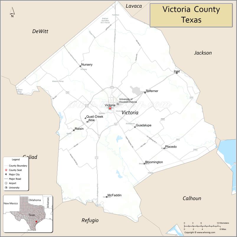
About Victoria County Map, Texas: The map showing the county boundary, county seat, major cities, highways, water bodies and neighbouring counties.
Related Texas Maps
Map of Victoria County, Texas
Victoria County is a county located in the U.S. state of Texas. It's county seat is Victoria. As per 2020 census, the population of Victoria County is 90964 people and population density is square miles. According to the United States Census Bureau, the county has a total area of 883 sq mi (2,287 km2). Victoria County was established on 1836.
Facts about Victoria County, Texas
| Country | United States |
| State | Texas |
| Region | South Texas / Coastal Plains |
| County Seat | Victoria |
| Named After | Guadalupe Victoria, first President of Mexico |
| Established | 1836 |
| Organized | 1837 |
| Coordinates | 28.7960° N, 96.9710° W |
| Total Area | 882 sq mi |
| Land Area | 883 sq mi |
| Water Area | 7 sq mi |
| Population (2020) | 92,084 |
| Population Rank | Mid-sized county in South Texas |
| Major City | Victoria |
| Main Industries | Manufacturing, Healthcare, Education, Energy, Retail |
| Major Airport | Victoria Regional Airport |
| Time Zone | Central Time (UTC−06:00) |
| Known For | Crossroads region, Historic downtown Victoria, Guadalupe River |
| Website | https://www.victoriacountytx.gov |
Top Attractions in Victoria County, Texas
- Riverside Park – Trails, gardens, and river views.
- Texas Zoo – Native Texas wildlife exhibits.
- Victoria Downtown Historic District – Shops and historic charm.
- Victoria County Courthouse – Landmark historic courthouse.
- Children’s Discovery Museum – Hands-on family exhibits.
- Nave Museum – Regional art exhibitions.
- Riverside Golf Course – Public course along the river.
- Memorial Square – Monuments and community events.
- Guadalupe River Access – Fishing and scenic riverbanks.
- Nearby Coastal Prairie Drives – Open landscapes and wildlife.
Cities and Towns in Victoria County, Texas
| Place | Type | Population (Census 2020) | Latitude & Longitude |
|---|---|---|---|
| Victoria (county seat) | City | 65154 | 28.8053°N, 97.0036°W |
| Bloomington | Census Designated Place (CDP) | 2045 | 28.6472°N, 96.8922°W |
| Inez | Census Designated Place (CDP) | 2098 | 28.8786°N, 96.7758°W |
| Placedo | Census Designated Place (CDP) | 1014 | 28.6889°N, 96.8461°W |
| Quail Creek | Census Designated Place (CDP) | 1628 | 28.8395°N, 97.0187°W |
| McFaddin | Unincorporated Community | N/A | 28.5611°N, 96.7167°W |
| Moursund | Unincorporated Community | N/A | 28.9522°N, 97.0914°W |
| Nursery | Unincorporated Community | N/A | 28.9219°N, 97.1022°W |
| Telferner | Unincorporated Community | N/A | 28.8489°N, 96.8964°W |
| Wood Hi | Unincorporated Community | N/A | 28.7647°N, 96.8219°W |
What are Major Roads and Highways in Victoria County
Major highways connect the county to nearby regions and cities.
- U.S. Highway 59 (Future Interstate 69) - connects Victoria with Houston, Wharton, Laredo, and South Texas
- U.S. Highway 77 (Future Interstate 69E) - north-south route linking Victoria with Corpus Christi and the Dallas-Fort Worth region
- U.S. Highway 87 - connects Victoria with Port Lavaca, Cuero, and San Antonio
- U.S. Highway 59 Business - serves central Victoria
- Loop 463 - outer loop around Victoria providing access to commercial districts
- State Highway 185 - connects Victoria with Port O'Connor and coastal communities
- Farm to Market Road 1685 - serves Inez and eastern Victoria County
- Farm to Market Road 236 - connects Nursery and rural agricultural communities
Victoria is known as the "Crossroads of South Texas" because several major U.S. highways intersect within the county. :contentReference[oaicite:0]{index=0}
What are Neighboring Counties of Victoria County
- Lavaca County (north)
- Jackson County (northeast)
- Calhoun County (southeast)
- Refugio County (south)
- Goliad County (southwest)
- DeWitt County (northwest)
Victoria County shares land boundaries with six Texas counties. :contentReference[oaicite:1]{index=1}
Distance from Victoria County to Nearby Cities
The following distances are measured by road (driving).
- Victoria to Bloomington (Victoria County), Texas - 13 mi (21 km)
- Victoria to Inez (Victoria County), Texas - 15 mi (24 km)
- Victoria to Placedo (Victoria County), Texas - 12 mi (19 km)
- Victoria to Cuero (DeWitt County), Texas - 29 mi (47 km)
- Victoria to Goliad (Goliad County), Texas - 29 mi (47 km)
- Victoria to Edna (Jackson County), Texas - 27 mi (43 km)
- Victoria to Port Lavaca (Calhoun County), Texas - 29 mi (47 km)
- Victoria to Refugio (Refugio County), Texas - 33 mi (53 km)
- Victoria to Hallettsville (Lavaca County), Texas - 42 mi (68 km)
- Victoria to Beeville (Bee County), Texas - 56 mi (90 km)
- Victoria to Bay City (Matagorda County), Texas - 72 mi (116 km)
- Victoria to Corpus Christi (Nueces County), Texas - 92 mi (148 km)
- Victoria to Houston (Harris County), Texas - 123 mi (198 km)
- Victoria to San Antonio (Bexar County), Texas - 128 mi (206 km)
- Victoria to Austin (Travis County), Texas - 122 mi (196 km)
Waterbodies in Victoria County
Guadalupe River, Coleto Creek, Garcitas Creek, Mission Creek, Placedo Creek, Spring Creek, Perdido Creek, Hensley Lake, Coleto Creek Reservoir, Lower Guadalupe River Basin, Mustang Creek, Swan Lake, Venado Creek, Guadalupe Estuary Watershed
Best Golf Courses in Victoria County, Texas
| Golf Course | Location | Latitude & Longitude |
|---|---|---|
| Victoria Country Club | Victoria | 28.8252°N, 97.0191°W |
| The Club at Colony Creek | Victoria | 28.8579°N, 97.0494°W |
| Riverside Golf Course | Victoria | 28.8164°N, 97.0028°W |
Colleges and Universities in Victoria County, Texas
| Institution Name | Type (Public/Private) | Level | Notable For |
|---|---|---|---|
| University of Houston-Victoria | Public | University | Regional public university offering undergraduate and graduate programs |
| Victoria College | Public | Community College | Main community college serving Victoria County |
| Texas A&M University System RELLIS Partnership Programs | Public | University | Regional higher education opportunities |
| University of Houston System at Victoria | Public | University | Business, education, and nursing programs |
| Victoria College Emerging Technology Complex | Public | Community College | Workforce and technical education training |
References
- U.S. Census Bureau QuickFacts - Victoria County
- City of Victoria Demographics and Growth Reports
- Victoria College
- Official Victoria County Website
- USGS Geographic Names Information System (GNIS)
- Anderson County Map
- Andrews County Map
- Angelina County Map
- Aransas County Map
- Archer County Map
- Armstrong County Map
- Atascosa County Map
- Austin County Map
- Bailey County Map
- Bandera County Map
- Bastrop County Map
- Baylor County Map
- Bee County Map
- Bell County Map
- Bexar County Map
- Blanco County Map
- Borden County Map
- Bosque County Map
- Bowie County Map
- Brazoria County Map
- Brazos County Map
- Brewster County Map
- Briscoe County Map
- Brooks County Map
- Brown County Map
- Burleson County Map
- Burnet County Map
- Caldwell County Map
- Calhoun County Map
- Callahan County Map
- Cameron County Map
- Camp County Map
- Carson County Map
- Cass County Map
- Castro County Map
- Chambers County Map
- Cherokee County Map
- Childress County Map
- Clay County Map
- Cochran County Map
- Coke County Map
- Coleman County Map
- Collin County Map
- Collingsworth County Map
- Colorado County Map
- Comal County Map
- Comanche County Map
- Concho County Map
- Cooke County Map
- Coryell County Map
- Cottle County Map
- Crane County Map
- Crockett County Map
- Crosby County Map
- Culberson County Map
- Dallam County Map
- Dallas County Map
- Dawson County Map
- Deaf Smith County Map
- Delta County Map
- Denton County Map
- DeWitt County Map
- Dickens County Map
- Dimmit County Map
- Donley County Map
- Duval County Map
- Eastland County Map
- Ector County Map
- Edwards County Map
- Ellis County Map
- El Paso County Map
- Erath County Map
- Falls County Map
- Fannin County Map
- Fayette County Map
- Fisher County Map
- Floyd County Map
- Foard County Map
- Fort Bend County Map
- Franklin County Map
- Freestone County Map
- Frio County Map
- Gaines County Map
- Galveston County Map
- Garza County Map
- Gillespie County Map
- Glasscock County Map
- Goliad County Map
- Gonzales County Map
- Gray County Map
- Grayson County Map
- Gregg County Map
- Grimes County Map
- Guadalupe County Map
- Hale County Map
- Hall County Map
- Hamilton County Map
- Hansford County Map
- Hardeman County Map
- Hardin County Map
- Harris County Map
- Harrison County Map
- Hartley County Map
- Haskell County Map
- Hays County Map
- Hemphill County Map
- Henderson County Map
- Hidalgo County Map
- Hill County Map
- Hockley County Map
- Hood County Map
- Hopkins County Map
- Houston County Map
- Howard County Map
- Hudspeth County Map
- Hunt County Map
- Hutchinson County Map
- Irion County Map
- Jack County Map
- Jackson County Map
- Jasper County Map
- Jeff Davis County Map
- Jefferson County Map
- Jim Hogg County Map
- Jim Wells County Map
- Johnson County Map
- Jones County Map
- Karnes County Map
- Kaufman County Map
- Kendall County Map
- Kenedy County Map
- Kent County Map
- Kerr County Map
- Kimble County Map
- King County Map
- Kinney County Map
- Kleberg County Map
- Knox County Map
- Lamar County Map
- Lamb County Map
- Lampasas County Map
- La Salle County Map
- Lavaca County Map
- Lee County Map
- Leon County Map
- Liberty County Map
- Limestone County Map
- Lipscomb County Map
- Live Oak County Map
- Llano County Map
- Loving County Map
- Lubbock County Map
- Lynn County Map
- McCulloch County Map
- McLennan County Map
- McMullen County Map
- Madison County Map
- Marion County Map
- Martin County Map
- Mason County Map
- Matagorda County Map
- Maverick County Map
- Medina County Map
- Menard County Map
- Midland County Map
- Milam County Map
- Mills County Map
- Mitchell County Map
- Montague County Map
- Montgomery County Map
- Moore County Map
- Morris County Map
- Motley County Map
- Nacogdoches County Map
- Navarro County Map
- Newton County Map
- Nolan County Map
- Nueces County Map
- Ochiltree County Map
- Oldham County Map
- Orange County Map
- Palo Pinto County Map
- Panola County Map
- Parker County Map
- Parmer County Map
- Pecos County Map
- Polk County Map
- Potter County Map
- Presidio County Map
- Rains County Map
- Randall County Map
- Reagan County Map
- Real County Map
- Red River County Map
- Reeves County Map
- Refugio County Map
- Roberts County Map
- Robertson County Map
- Rockwall County Map
- Runnels County Map
- Rusk County Map
- Sabine County Map
- San Augustine County Map
- San Jacinto County Map
- San Patricio County Map
- San Saba County Map
- Schleicher County Map
- Scurry County Map
- Shackelford County Map
- Shelby County Map
- Sherman County Map
- Smith County Map
- Somervell County Map
- Starr County Map
- Stephens County Map
- Sterling County Map
- Stonewall County Map
- Sutton County Map
- Swisher County Map
- Tarrant County Map
- Taylor County Map
- Terrell County Map
- Terry County Map
- Throckmorton County Map
- Titus County Map
- Tom Green County Map
- Travis County Map
- Trinity County Map
- Tyler County Map
- Upshur County Map
- Upton County Map
- Uvalde County Map
- Val Verde County Map
- Van Zandt County Map
- Victoria County Map
- Walker County Map
- Waller County Map
- Ward County Map
- Washington County Map
- Webb County Map
- Wharton County Map
- Wheeler County Map
- Wichita County Map
- Wilbarger County Map
- Willacy County Map
- Williamson County Map
- Wilson County Map
- Winkler County Map
- Wise County Map
- Wood County Map
- Yoakum County Map
- Young County Map
- Zapata County Map
- Zavala County Map
- Alabama Counties
- Alaska boroughs
- Arizona Counties
- Arkansas Counties
- California County Map
- Colorado Counties
- Connecticut Counties
- Delaware Counties
- Florida County Map
- Georgia County Map
- Hawaii Counties
- Idaho Counties
- Illinois Counties
- Indiana Counties
- Iowa Counties
- Kansas Counties
- Kentucky Counties
- Louisiana Counties
- Maine Counties
- Maryland Counties
- Massachusetts Counties
- Michigan County Map
- Minnesota Counties
- Mississippi Counties
- Missouri Counties
- Montana Counties
- Nebraska Counties
- Nevada Counties
- New York Counties
- New Hampshire Counties
- New Jersey Counties
- New Mexico Counties
- North Carolina Counties
- North Dakota Counties
- Ohio County Map
- Oklahoma Counties
- Oregon Counties
- Pennsylvania Counties
- Rhode Island Counties
- South Carolina Counties
- South Dakota Counties
- Map of Tennessee
- Texas County Map
- Utah Counties
- Vermont Counties
- Virginia Counties
- Washington Counties
- West Virginia Counties
- Wisconsin Counties
- Wyoming Counties
References
- ^ QuickFacts: Victoria County, Texas - United States Census Bureau
- ^ United States Census Bureau - Population and Housing Data
- ^ TIGER/Line Shapefiles - United States Census Bureau
- ^ United States Geological Survey (USGS)
- ^ National Geodetic Survey (NGS), NOAA
- ^ Official Website of Victoria County, Texas
- ^ Texas Department of Transportation (TxDOT)