Map of Cooke County - Cooke County is a county located in the U.S. state of Texas. Cooke County Map showing cities, highways, important places and water bodies. Get Where is Cooke County located in the map, major cities in Cooke county, population, areas, and places of interest.
Map of Cooke County, Texas
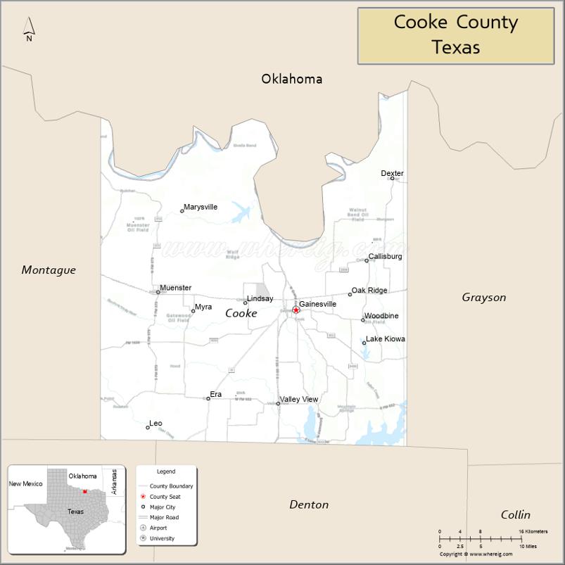
About Cooke County Map, Texas: The map showing the county boundary, county seat, major cities, highways, water bodies and neighbouring counties.
Related Texas Maps
Map of Cooke County, Texas
Cooke County is a county located in the U.S. state of Texas. It's county seat is Gainesville. As per 2020 census, the population of Cooke County is 42244 people and population density is square miles. According to the United States Census Bureau, the county has a total area of 874 sq mi (2,264 km2). Cooke County was established on 1848.
Facts about Cooke County, Texas
| Country | United States |
| State | Texas |
| Region | North Texas |
| County Seat | Gainesville |
| Named After | William Gordon Cooke |
| Established | 1848 |
| Organized | 1849 |
| Coordinates | 33.6540° N, 97.2210° W |
| Total Area | 898 sq mi |
| Land Area | 875 sq mi |
| Water Area | 23 sq mi |
| Population (2020) | 41,257 |
| Population Rank | Moderately populated North Texas county |
| Major City | Gainesville |
| Main Industries | Manufacturing, Agriculture, Retail, Tourism |
| Major Airport | Gainesville Municipal Airport |
| Time Zone | Central Time (UTC−06:00) |
| Known For | Frank Buck Zoo, Outlet shopping, Lake Ray Roberts (nearby), German heritage |
| Website | https://www.co.cooke.tx.us |
Top Attractions in Cooke County, Texas
- Frank Buck Zoo (Gainesville) – Family-friendly zoo with global animal exhibits.
- Lake Ray Roberts – Boating, fishing, hiking, and lakeside camping.
- Ray Roberts Lake State Park – Isle du Bois Unit – Scenic trails, swimming areas, and picnic spots.
- Morton Museum of Cooke County – Local history exhibits and cultural displays.
- Gainesville Downtown Historic District – Shops, dining, murals, and historic buildings.
- Lavender Ridge Farms – Seasonal lavender fields, gardens, and a farm café.
- WinStar World Casino (Nearby in Oklahoma) – Popular entertainment and gaming destination just across the border.
- Ray Roberts Greenbelt – Trails for biking, horseback riding, and nature walks.
- Gainesville Farmers Market – Local produce, crafts, and community events.
- State Theatre (Gainesville) – Restored venue hosting movies and live events.
Cities and Towns in Cooke County, Texas
| Place | Type | Population (Census 2020) | Latitude & Longitude |
|---|---|---|---|
| Gainesville (county seat) | City | 16820 | 33.6259°N, 97.1331°W |
| Callisburg | City | 353 | 33.6948°N, 97.0186°W |
| Lindsay | City | 1104 | 33.6354°N, 97.2228°W |
| Muenster | City | 1607 | 33.6515°N, 97.3764°W |
| Valley View | City | 757 | 33.4884°N, 97.1653°W |
| Oak Ridge | Town | 242 | 33.6384°N, 97.0241°W |
| Road Runner | Town | 197 | 33.6330°N, 97.0108°W |
| Lake Kiowa | Census Designated Place (CDP) | 1906 | 33.5744°N, 97.0053°W |
| Myra | Census Designated Place (CDP) | 245 | 33.6346°N, 97.2919°W |
| Bulcher | Unincorporated Community | N/A | 33.7484°N, 97.4836°W |
| Burns City | Unincorporated Community | N/A | 33.7478°N, 97.3228°W |
| Dexter | Unincorporated Community | N/A | 33.8159°N, 97.1474°W |
| Era | Unincorporated Community | N/A | 33.4984°N, 97.2897°W |
| Marysville | Unincorporated Community | N/A | 33.8917°N, 97.2231°W |
| Mountain Springs | Unincorporated Community | N/A | 33.5191°N, 97.0414°W |
| Rosston | Unincorporated Community | N/A | 33.4948°N, 97.4395°W |
| Sivells Bend | Unincorporated Community | N/A | 33.8776°N, 97.4108°W |
| Walnut Bend | Unincorporated Community | N/A | 33.7812°N, 97.5065°W |
| Woodbine | Unincorporated Community | N/A | 33.6532°N, 96.9957°W |
What are Major Roads and Highways in Cooke County
Major highways connect the county to nearby regions and cities.
- Interstate 35 - north toward Oklahoma and south toward Denton and Dallas
- U.S. Highway 77 - north-south route through Gainesville and Valley View
- U.S. Highway 82 - east-west route connecting Gainesville, Sherman, and Wichita Falls
- Farm to Market Road 51 - serves western Cooke County communities
- Farm to Market Road 678 - connects Muenster and surrounding agricultural areas
- Farm to Market Road 922 - serves Valley View and southern parts of the county
- Farm to Market Road 1200 - links Gainesville with eastern rural communities
What are Neighboring Counties of Cooke County
- Love County, Oklahoma (north)
- Grayson County (east)
- Denton County (south)
- Wise County (southwest)
- Montague County (west)
Distance from Cooke County to Nearby Cities
The following distances are measured by road (driving).
- Gainesville to Callisburg (Cooke County), Texas - 7 mi (11 km)
- Gainesville to Lindsay (Cooke County), Texas - 7 mi (11 km)
- Gainesville to Muenster (Cooke County), Texas - 15 mi (24 km)
- Gainesville to Valley View (Cooke County), Texas - 15 mi (24 km)
- Gainesville to Lake Kiowa (Cooke County), Texas - 10 mi (16 km)
- Gainesville to Sherman (Grayson County), Texas - 33 mi (53 km)
- Gainesville to Denton (Denton County), Texas - 36 mi (58 km)
- Gainesville to Decatur (Wise County), Texas - 39 mi (63 km)
- Gainesville to Bowie (Montague County), Texas - 38 mi (61 km)
- Gainesville to Ardmore, Oklahoma - 29 mi (47 km)
- Gainesville to Whitesboro (Grayson County), Texas - 13 mi (21 km)
- Gainesville to Nocona (Montague County), Texas - 42 mi (68 km)
- Gainesville to McKinney (Collin County), Texas - 48 mi (77 km)
- Gainesville to Fort Worth (Tarrant County), Texas - 74 mi (119 km)
- Gainesville to Dallas (Dallas County), Texas - 69 mi (111 km)
Waterbodies in Cooke County
Red River, Lake Ray Roberts, Moss Lake, Clear Creek, Elm Fork Trinity River, Timber Creek, Fish Creek, Mineral Creek, Range Creek, Walnut Creek, Jordan Creek, Lake Kiowa, Trinity River watershed, wetlands, reservoirs, stock ponds, springs, and seasonal streams
Best Golf Courses in Cooke County, Texas
| Golf Course | Location | Latitude & Longitude |
|---|---|---|
| Gainesville Municipal Golf Course | Gainesville | 33.6518°N, 97.1428°W |
| Lake Kiowa Golf Club | Lake Kiowa | 33.5771°N, 97.0124°W |
| Turtle Hill Golf Course | Muenster | 33.6447°N, 97.3684°W |
Colleges and Universities in Cooke County, Texas
| Institution Name | Type | Level | Notable For |
|---|---|---|---|
| North Central Texas College | Public | Community College | Main higher education institution in Gainesville |
| North Central Texas College - Gainesville Campus | Public | Community College | Associate degrees and workforce training |
| Texas A&M AgriLife Extension Service - Cooke County | Public | University | Agricultural and community education programs |
References
- U.S. Census Bureau - Cooke County QuickFacts
- Official Cooke County Website
- Texas State Historical Association - Cooke County
- North Central Texas College
- PGA of America - Golf Courses in Cooke County
- Anderson County Map
- Andrews County Map
- Angelina County Map
- Aransas County Map
- Archer County Map
- Armstrong County Map
- Atascosa County Map
- Austin County Map
- Bailey County Map
- Bandera County Map
- Bastrop County Map
- Baylor County Map
- Bee County Map
- Bell County Map
- Bexar County Map
- Blanco County Map
- Borden County Map
- Bosque County Map
- Bowie County Map
- Brazoria County Map
- Brazos County Map
- Brewster County Map
- Briscoe County Map
- Brooks County Map
- Brown County Map
- Burleson County Map
- Burnet County Map
- Caldwell County Map
- Calhoun County Map
- Callahan County Map
- Cameron County Map
- Camp County Map
- Carson County Map
- Cass County Map
- Castro County Map
- Chambers County Map
- Cherokee County Map
- Childress County Map
- Clay County Map
- Cochran County Map
- Coke County Map
- Coleman County Map
- Collin County Map
- Collingsworth County Map
- Colorado County Map
- Comal County Map
- Comanche County Map
- Concho County Map
- Cooke County Map
- Coryell County Map
- Cottle County Map
- Crane County Map
- Crockett County Map
- Crosby County Map
- Culberson County Map
- Dallam County Map
- Dallas County Map
- Dawson County Map
- Deaf Smith County Map
- Delta County Map
- Denton County Map
- DeWitt County Map
- Dickens County Map
- Dimmit County Map
- Donley County Map
- Duval County Map
- Eastland County Map
- Ector County Map
- Edwards County Map
- Ellis County Map
- El Paso County Map
- Erath County Map
- Falls County Map
- Fannin County Map
- Fayette County Map
- Fisher County Map
- Floyd County Map
- Foard County Map
- Fort Bend County Map
- Franklin County Map
- Freestone County Map
- Frio County Map
- Gaines County Map
- Galveston County Map
- Garza County Map
- Gillespie County Map
- Glasscock County Map
- Goliad County Map
- Gonzales County Map
- Gray County Map
- Grayson County Map
- Gregg County Map
- Grimes County Map
- Guadalupe County Map
- Hale County Map
- Hall County Map
- Hamilton County Map
- Hansford County Map
- Hardeman County Map
- Hardin County Map
- Harris County Map
- Harrison County Map
- Hartley County Map
- Haskell County Map
- Hays County Map
- Hemphill County Map
- Henderson County Map
- Hidalgo County Map
- Hill County Map
- Hockley County Map
- Hood County Map
- Hopkins County Map
- Houston County Map
- Howard County Map
- Hudspeth County Map
- Hunt County Map
- Hutchinson County Map
- Irion County Map
- Jack County Map
- Jackson County Map
- Jasper County Map
- Jeff Davis County Map
- Jefferson County Map
- Jim Hogg County Map
- Jim Wells County Map
- Johnson County Map
- Jones County Map
- Karnes County Map
- Kaufman County Map
- Kendall County Map
- Kenedy County Map
- Kent County Map
- Kerr County Map
- Kimble County Map
- King County Map
- Kinney County Map
- Kleberg County Map
- Knox County Map
- Lamar County Map
- Lamb County Map
- Lampasas County Map
- La Salle County Map
- Lavaca County Map
- Lee County Map
- Leon County Map
- Liberty County Map
- Limestone County Map
- Lipscomb County Map
- Live Oak County Map
- Llano County Map
- Loving County Map
- Lubbock County Map
- Lynn County Map
- McCulloch County Map
- McLennan County Map
- McMullen County Map
- Madison County Map
- Marion County Map
- Martin County Map
- Mason County Map
- Matagorda County Map
- Maverick County Map
- Medina County Map
- Menard County Map
- Midland County Map
- Milam County Map
- Mills County Map
- Mitchell County Map
- Montague County Map
- Montgomery County Map
- Moore County Map
- Morris County Map
- Motley County Map
- Nacogdoches County Map
- Navarro County Map
- Newton County Map
- Nolan County Map
- Nueces County Map
- Ochiltree County Map
- Oldham County Map
- Orange County Map
- Palo Pinto County Map
- Panola County Map
- Parker County Map
- Parmer County Map
- Pecos County Map
- Polk County Map
- Potter County Map
- Presidio County Map
- Rains County Map
- Randall County Map
- Reagan County Map
- Real County Map
- Red River County Map
- Reeves County Map
- Refugio County Map
- Roberts County Map
- Robertson County Map
- Rockwall County Map
- Runnels County Map
- Rusk County Map
- Sabine County Map
- San Augustine County Map
- San Jacinto County Map
- San Patricio County Map
- San Saba County Map
- Schleicher County Map
- Scurry County Map
- Shackelford County Map
- Shelby County Map
- Sherman County Map
- Smith County Map
- Somervell County Map
- Starr County Map
- Stephens County Map
- Sterling County Map
- Stonewall County Map
- Sutton County Map
- Swisher County Map
- Tarrant County Map
- Taylor County Map
- Terrell County Map
- Terry County Map
- Throckmorton County Map
- Titus County Map
- Tom Green County Map
- Travis County Map
- Trinity County Map
- Tyler County Map
- Upshur County Map
- Upton County Map
- Uvalde County Map
- Val Verde County Map
- Van Zandt County Map
- Victoria County Map
- Walker County Map
- Waller County Map
- Ward County Map
- Washington County Map
- Webb County Map
- Wharton County Map
- Wheeler County Map
- Wichita County Map
- Wilbarger County Map
- Willacy County Map
- Williamson County Map
- Wilson County Map
- Winkler County Map
- Wise County Map
- Wood County Map
- Yoakum County Map
- Young County Map
- Zapata County Map
- Zavala County Map
- Alabama Counties
- Alaska boroughs
- Arizona Counties
- Arkansas Counties
- California County Map
- Colorado Counties
- Connecticut Counties
- Delaware Counties
- Florida County Map
- Georgia County Map
- Hawaii Counties
- Idaho Counties
- Illinois Counties
- Indiana Counties
- Iowa Counties
- Kansas Counties
- Kentucky Counties
- Louisiana Counties
- Maine Counties
- Maryland Counties
- Massachusetts Counties
- Michigan County Map
- Minnesota Counties
- Mississippi Counties
- Missouri Counties
- Montana Counties
- Nebraska Counties
- Nevada Counties
- New York Counties
- New Hampshire Counties
- New Jersey Counties
- New Mexico Counties
- North Carolina Counties
- North Dakota Counties
- Ohio County Map
- Oklahoma Counties
- Oregon Counties
- Pennsylvania Counties
- Rhode Island Counties
- South Carolina Counties
- South Dakota Counties
- Map of Tennessee
- Texas County Map
- Utah Counties
- Vermont Counties
- Virginia Counties
- Washington Counties
- West Virginia Counties
- Wisconsin Counties
- Wyoming Counties
References
- ^ QuickFacts: Cooke County, Texas - United States Census Bureau
- ^ United States Census Bureau - Population and Housing Data
- ^ TIGER/Line Shapefiles - United States Census Bureau
- ^ United States Geological Survey (USGS)
- ^ National Geodetic Survey (NGS), NOAA
- ^ Official Website of Cooke County, Texas
- ^ Texas Department of Transportation (TxDOT)