Map of San Patricio County - San Patricio County is a county located in the U.S. state of Texas. San Patricio County Map showing cities, highways, important places and water bodies. Get Where is San Patricio County located in the map, major cities in San Patricio county, population, areas, and places of interest.
Map of San Patricio County, Texas
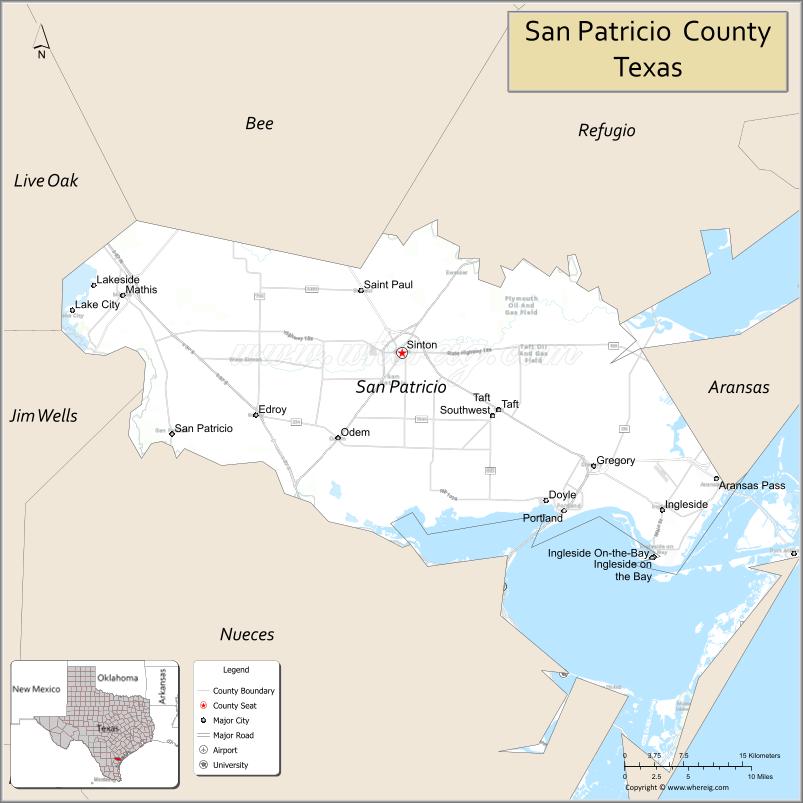
About San Patricio County Map, Texas: The map showing the county boundary, county seat, major cities, highways, water bodies and neighbouring counties.
Related Texas Maps
Map of San Patricio County, Texas
San Patricio County is a county located in the U.S. state of Texas. It's county seat is Sinton. As per 2020 census, the population of San Patricio County is 69699 people and population density is square miles. According to the United States Census Bureau, the county has a total area of 692 sq mi (1,792 km2). San Patricio County was established on 1836.
Facts about San Patricio County, Texas
| Country | United States |
| State | Texas |
| Region | South Texas / Coastal Bend |
| County Seat | Sinton |
| Named After | Saint Patrick (Irish heritage of early settlers) |
| Established | 1836 |
| Organized | 1837 |
| Coordinates | 27.9790° N, 97.5200° W |
| Total Area | 707 sq mi |
| Land Area | 601 sq mi |
| Water Area | 106 sq mi |
| Population (2020) | 68,755 |
| Population Rank | Mid-sized county in the Coastal Bend |
| Major City | Sinton |
| Main Industries | Energy, Petrochemicals, Agriculture, Manufacturing, Port Services |
| Major Airport | None (near Corpus Christi International Airport) |
| Time Zone | Central Time (UTC−06:00) |
| Known For | Port of Corpus Christi access, Wind energy projects, Coastal prairie |
| Website | https://www.co.san-patricio.tx.us |
Top Attractions in San Patricio County, Texas
- Welder Wildlife Refuge – Birdwatching and native habitats.
- Sinton Downtown Square – Shops, cafés, and small-town charm.
- San Patricio County Courthouse – Historic courthouse landmark.
- Lake Corpus Christi State Park – Camping, fishing, and boating.
- Mathis Lake Area – Fishing and lakeside relaxation.
- Portland Sunset Lake Park – Walking paths and sunset views.
- Gregory Community Park – Sports fields and picnic areas.
- Aransas River Areas – Scenic river views and fishing spots.
- Odem Heritage Museum – Local history and exhibits.
- Rural Coastal Prairie Drives – Open landscapes and wildlife.
Cities and Towns in San Patricio County, Texas
| Place | Type | Population (Census 2020) | Latitude & Longitude |
|---|---|---|---|
| Sinton (county seat) | City | 5665 | 28.0367°N, 97.5094°W |
| Aransas Pass (partly in Aransas County) | City | 8178 | 27.9095°N, 97.1494°W |
| Portland | City | 20400 | 27.8792°N, 97.3230°W |
| Ingleside | City | 9387 | 27.8775°N, 97.2111°W |
| Mathis | City | 4942 | 28.0947°N, 97.8281°W |
| Odem | City | 2389 | 27.9514°N, 97.5825°W |
| Taft | City | 3065 | 27.9781°N, 97.3983°W |
| Gregory | City | 1740 | 27.9203°N, 97.2892°W |
| Ingleside on the Bay | City | 613 | 27.8328°N, 97.2092°W |
| Edroy | Census Designated Place (CDP) | 331 | 27.9994°N, 97.6731°W |
| San Patricio | Census Designated Place (CDP) | 395 | 28.0175°N, 97.7756°W |
| St. Paul | Town | 1041 | 27.9906°N, 97.3569°W |
| Bayside | Town | 325 | 28.0950°N, 97.2140°W |
What are Major Roads and Highways in San Patricio County
Major highways connect the county to nearby regions and cities.
- Interstate 37 - connects the county with Corpus Christi, San Antonio, and South Texas
- U.S. Highway 77 (Future Interstate 69E) - north-south corridor connecting Sinton with Robstown, Kingsville, and Victoria
- U.S. Highway 181 - links Portland, Gregory, and Sinton with Corpus Christi and Beeville
- State Highway 35 - coastal route connecting Aransas Pass, Rockport, and Port Lavaca
- State Highway 188 - connects Sinton with Mathis and coastal communities
- Farm to Market Road 1069 - serves Portland and Ingleside areas
- Farm to Market Road 1945 - provides access to northern portions of the county
What are Neighboring Counties of San Patricio County
- Refugio County (north)
- Aransas County (northeast)
- Nueces County (south)
- Jim Wells County (southwest)
- Live Oak County (west)
- Bee County (northwest)
Distance from San Patricio County to Nearby Cities
The following distances are measured by road (driving).
- Sinton to Odem (San Patricio County), Texas - 8 mi (13 km)
- Sinton to Taft (San Patricio County), Texas - 11 mi (18 km)
- Sinton to Gregory (San Patricio County), Texas - 16 mi (26 km)
- Sinton to Portland (San Patricio County), Texas - 18 mi (29 km)
- Sinton to Ingleside (San Patricio County), Texas - 22 mi (35 km)
- Sinton to Aransas Pass (San Patricio County), Texas - 24 mi (39 km)
- Sinton to Mathis (San Patricio County), Texas - 27 mi (43 km)
- Sinton to Corpus Christi (Nueces County), Texas - 29 mi (47 km)
- Sinton to Robstown (Nueces County), Texas - 21 mi (34 km)
- Sinton to Beeville (Bee County), Texas - 46 mi (74 km)
- Sinton to Rockport (Aransas County), Texas - 30 mi (48 km)
- Sinton to Kingsville (Kleberg County), Texas - 47 mi (76 km)
- Sinton to Refugio (Refugio County), Texas - 39 mi (63 km)
- Sinton to Victoria (Victoria County), Texas - 83 mi (134 km)
- Sinton to San Antonio (Bexar County), Texas - 143 mi (230 km)
Waterbodies in San Patricio County
Corpus Christi Bay, Nueces Bay, Redfish Bay, Aransas Bay, La Quinta Channel, Chiltipin Creek, Nueces River, Lake Corpus Christi, Oso Creek Tributaries, Copano Bay Watershed, Rincon Bayou, Mission River Delta, Port Bay, Corpus Christi Ship Channel
Best Golf Courses in San Patricio County, Texas
| Golf Course | Location | Latitude & Longitude |
|---|---|---|
| NorthShore Country Club | Portland | 27.8768°N, 97.2866°W |
| Ingleside on the Bay Golf Course | Ingleside on the Bay | 27.8323°N, 97.2095°W |
| Live Oak Country Club | Rockport area (serving Aransas Pass residents) | 27.9820°N, 97.1400°W |
Colleges and Universities in San Patricio County, Texas
San Patricio County does not have a major four-year university campus within its boundaries. Residents are primarily served by colleges and universities in the Corpus Christi metropolitan area and Coastal Bend region.
| Institution Name | Type (Public/Private) | Level | Notable For |
|---|---|---|---|
| Del Mar College | Public | Community College | Primary community college serving the Coastal Bend region |
| Texas A&M University-Corpus Christi | Public | University | Major coastal research university |
| Coastal Bend College | Public | Community College | Serves portions of western San Patricio County |
| University of Houston-Victoria | Public | University | Regional public university serving South Texas |
| Texas A&M University-Kingsville | Public | University | Engineering and agriculture programs |
References
- U.S. Census Bureau - 2020 Census Data for San Patricio County and Communities
- U.S. Census Bureau QuickFacts - San Patricio County
- Official San Patricio County Website
- Texas State Historical Association - San Patricio County
- USGS Geographic Names Information System (GNIS)
- Anderson County Map
- Andrews County Map
- Angelina County Map
- Aransas County Map
- Archer County Map
- Armstrong County Map
- Atascosa County Map
- Austin County Map
- Bailey County Map
- Bandera County Map
- Bastrop County Map
- Baylor County Map
- Bee County Map
- Bell County Map
- Bexar County Map
- Blanco County Map
- Borden County Map
- Bosque County Map
- Bowie County Map
- Brazoria County Map
- Brazos County Map
- Brewster County Map
- Briscoe County Map
- Brooks County Map
- Brown County Map
- Burleson County Map
- Burnet County Map
- Caldwell County Map
- Calhoun County Map
- Callahan County Map
- Cameron County Map
- Camp County Map
- Carson County Map
- Cass County Map
- Castro County Map
- Chambers County Map
- Cherokee County Map
- Childress County Map
- Clay County Map
- Cochran County Map
- Coke County Map
- Coleman County Map
- Collin County Map
- Collingsworth County Map
- Colorado County Map
- Comal County Map
- Comanche County Map
- Concho County Map
- Cooke County Map
- Coryell County Map
- Cottle County Map
- Crane County Map
- Crockett County Map
- Crosby County Map
- Culberson County Map
- Dallam County Map
- Dallas County Map
- Dawson County Map
- Deaf Smith County Map
- Delta County Map
- Denton County Map
- DeWitt County Map
- Dickens County Map
- Dimmit County Map
- Donley County Map
- Duval County Map
- Eastland County Map
- Ector County Map
- Edwards County Map
- Ellis County Map
- El Paso County Map
- Erath County Map
- Falls County Map
- Fannin County Map
- Fayette County Map
- Fisher County Map
- Floyd County Map
- Foard County Map
- Fort Bend County Map
- Franklin County Map
- Freestone County Map
- Frio County Map
- Gaines County Map
- Galveston County Map
- Garza County Map
- Gillespie County Map
- Glasscock County Map
- Goliad County Map
- Gonzales County Map
- Gray County Map
- Grayson County Map
- Gregg County Map
- Grimes County Map
- Guadalupe County Map
- Hale County Map
- Hall County Map
- Hamilton County Map
- Hansford County Map
- Hardeman County Map
- Hardin County Map
- Harris County Map
- Harrison County Map
- Hartley County Map
- Haskell County Map
- Hays County Map
- Hemphill County Map
- Henderson County Map
- Hidalgo County Map
- Hill County Map
- Hockley County Map
- Hood County Map
- Hopkins County Map
- Houston County Map
- Howard County Map
- Hudspeth County Map
- Hunt County Map
- Hutchinson County Map
- Irion County Map
- Jack County Map
- Jackson County Map
- Jasper County Map
- Jeff Davis County Map
- Jefferson County Map
- Jim Hogg County Map
- Jim Wells County Map
- Johnson County Map
- Jones County Map
- Karnes County Map
- Kaufman County Map
- Kendall County Map
- Kenedy County Map
- Kent County Map
- Kerr County Map
- Kimble County Map
- King County Map
- Kinney County Map
- Kleberg County Map
- Knox County Map
- Lamar County Map
- Lamb County Map
- Lampasas County Map
- La Salle County Map
- Lavaca County Map
- Lee County Map
- Leon County Map
- Liberty County Map
- Limestone County Map
- Lipscomb County Map
- Live Oak County Map
- Llano County Map
- Loving County Map
- Lubbock County Map
- Lynn County Map
- McCulloch County Map
- McLennan County Map
- McMullen County Map
- Madison County Map
- Marion County Map
- Martin County Map
- Mason County Map
- Matagorda County Map
- Maverick County Map
- Medina County Map
- Menard County Map
- Midland County Map
- Milam County Map
- Mills County Map
- Mitchell County Map
- Montague County Map
- Montgomery County Map
- Moore County Map
- Morris County Map
- Motley County Map
- Nacogdoches County Map
- Navarro County Map
- Newton County Map
- Nolan County Map
- Nueces County Map
- Ochiltree County Map
- Oldham County Map
- Orange County Map
- Palo Pinto County Map
- Panola County Map
- Parker County Map
- Parmer County Map
- Pecos County Map
- Polk County Map
- Potter County Map
- Presidio County Map
- Rains County Map
- Randall County Map
- Reagan County Map
- Real County Map
- Red River County Map
- Reeves County Map
- Refugio County Map
- Roberts County Map
- Robertson County Map
- Rockwall County Map
- Runnels County Map
- Rusk County Map
- Sabine County Map
- San Augustine County Map
- San Jacinto County Map
- San Patricio County Map
- San Saba County Map
- Schleicher County Map
- Scurry County Map
- Shackelford County Map
- Shelby County Map
- Sherman County Map
- Smith County Map
- Somervell County Map
- Starr County Map
- Stephens County Map
- Sterling County Map
- Stonewall County Map
- Sutton County Map
- Swisher County Map
- Tarrant County Map
- Taylor County Map
- Terrell County Map
- Terry County Map
- Throckmorton County Map
- Titus County Map
- Tom Green County Map
- Travis County Map
- Trinity County Map
- Tyler County Map
- Upshur County Map
- Upton County Map
- Uvalde County Map
- Val Verde County Map
- Van Zandt County Map
- Victoria County Map
- Walker County Map
- Waller County Map
- Ward County Map
- Washington County Map
- Webb County Map
- Wharton County Map
- Wheeler County Map
- Wichita County Map
- Wilbarger County Map
- Willacy County Map
- Williamson County Map
- Wilson County Map
- Winkler County Map
- Wise County Map
- Wood County Map
- Yoakum County Map
- Young County Map
- Zapata County Map
- Zavala County Map
- Alabama Counties
- Alaska boroughs
- Arizona Counties
- Arkansas Counties
- California County Map
- Colorado Counties
- Connecticut Counties
- Delaware Counties
- Florida County Map
- Georgia County Map
- Hawaii Counties
- Idaho Counties
- Illinois Counties
- Indiana Counties
- Iowa Counties
- Kansas Counties
- Kentucky Counties
- Louisiana Counties
- Maine Counties
- Maryland Counties
- Massachusetts Counties
- Michigan County Map
- Minnesota Counties
- Mississippi Counties
- Missouri Counties
- Montana Counties
- Nebraska Counties
- Nevada Counties
- New York Counties
- New Hampshire Counties
- New Jersey Counties
- New Mexico Counties
- North Carolina Counties
- North Dakota Counties
- Ohio County Map
- Oklahoma Counties
- Oregon Counties
- Pennsylvania Counties
- Rhode Island Counties
- South Carolina Counties
- South Dakota Counties
- Map of Tennessee
- Texas County Map
- Utah Counties
- Vermont Counties
- Virginia Counties
- Washington Counties
- West Virginia Counties
- Wisconsin Counties
- Wyoming Counties
References
- ^ QuickFacts: San Patricio County, Texas - United States Census Bureau
- ^ United States Census Bureau - Population and Housing Data
- ^ TIGER/Line Shapefiles - United States Census Bureau
- ^ United States Geological Survey (USGS)
- ^ National Geodetic Survey (NGS), NOAA
- ^ Official Website of San Patricio County, Texas
- ^ Texas Department of Transportation (TxDOT)