Map of Taylor County - Taylor County is a county located in the U.S. state of Texas. Taylor County Map showing cities, highways, important places and water bodies. Get Where is Taylor County located in the map, major cities in Taylor county, population, areas, and places of interest.
Map of Taylor County, Texas
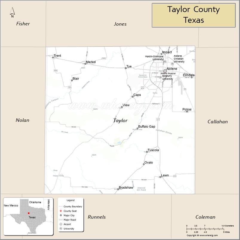
About Taylor County Map, Texas: The map showing the county boundary, county seat, major cities, highways, water bodies and neighbouring counties.
Related Texas Maps
Map of Taylor County, Texas
Taylor County is a county located in the U.S. state of Texas. It's county seat is Abilene. As per 2020 census, the population of Taylor County is 143326 people and population density is square miles. According to the United States Census Bureau, the county has a total area of 916 sq mi (2,372 km2). Taylor County was established on 1858.
Facts about Taylor County, Texas
| Country | United States |
| State | Texas |
| Region | West-Central Texas |
| County Seat | Abilene |
| Named After | Edward Taylor, Texas Ranger and early settler |
| Established | 1878 |
| Organized | 1883 |
| Coordinates | 32.3050° N, 99.8900° W |
| Total Area | 919 sq mi |
| Land Area | 915 sq mi |
| Water Area | 4 sq mi |
| Population (2020) | 145,262 |
| Population Rank | Major regional county in West-Central Texas |
| Major City | Abilene |
| Main Industries | Education, Military, Healthcare, Manufacturing, Energy |
| Major Airport | Abilene Regional Airport (ABI) |
| Time Zone | Central Time (UTC−06:00) |
| Known For | Dyess Air Force Base, Abilene Christian University, Frontier Texas! museum |
| Website | https://www.taylorcountytexas.org |
Top Attractions in Taylor County, Texas
- Frontier Texas! – Interactive Old West history museum.
- Abilene Zoo – Family-friendly animal exhibits.
- Downtown Abilene – Shops, dining, and local culture.
- 12th Armored Division Memorial Museum – WWII military history.
- Grace Museum – Art, history, and rotating exhibits.
- Buffalo Gap Historic Village – Preserved frontier town.
- Lake Fort Phantom Hill – Boating and fishing recreation.
- Abilene State Park (nearby access) – Camping and trails.
- Paramount Theatre – Historic performance venue.
- Nelson Park – Sports complex and outdoor fun.
Cities and Towns in Taylor County, Texas
| Place | Type | Population (Census 2020) | Latitude & Longitude |
|---|---|---|---|
| Abilene (county seat) | City | 125182 | 32.4487°N, 99.7331°W |
| Tuscola | City | 850 | 32.2087°N, 99.7962°W |
| Merkel | Town | 2590 | 32.4704°N, 100.0129°W |
| Trent | Town | 337 | 32.4865°N, 100.1234°W |
| Tye | City | 1242 | 32.4576°N, 99.8662°W |
| Buffalo Gap | City | 463 | 32.2812°N, 99.8309°W |
| Lawn | Town | 314 | 32.1368°N, 99.7476°W |
| Impact | Town | 35 | 32.4321°N, 99.8468°W |
| Ovalo | Unincorporated Community | N/A | 32.1735°N, 99.8137°W |
| Caps | Unincorporated Community | N/A | 32.3906°N, 99.8756°W |
| Potosi | Census Designated Place (CDP) | 2991 | 32.3162°N, 99.6828°W |
| View | Unincorporated Community | N/A | 32.3390°N, 99.6017°W |
| Shep | Unincorporated Community | N/A | 32.1167°N, 99.9181°W |
| Noodle | Unincorporated Community | N/A | 32.5503°N, 99.6403°W |
| Bradshaw | Unincorporated Community | N/A | 32.0510°N, 99.8865°W |
What are Major Roads and Highways in Taylor County
Major highways connect the county to nearby regions and cities.
- Interstate 20 - major east-west corridor connecting Abilene with Fort Worth, Midland, and El Paso
- U.S. Highway 83 - north-south route connecting Abilene with Hamlin, Ballinger, and South Texas
- U.S. Highway 84 - connects Abilene with Sweetwater, Snyder, and Lubbock
- U.S. Highway 277 - links Abilene with San Angelo and Wichita Falls
- State Highway 351 - connects Abilene with Albany and Jones County
- State Highway 36 - provides access to Callahan and Brown counties
- Loop 322 - beltway around Abilene
- Farm to Market Road 89 - serves Buffalo Gap and southern Taylor County
What are Neighboring Counties of Taylor County
- Jones County (north)
- Callahan County (east)
- Coleman County (south)
- Runnels County (southwest)
- Nolan County (west)
- Fisher County (northwest)
- Shackelford County (northeast)
Distance from Taylor County to Nearby Cities
The following distances are measured by road (driving).
- Abilene to Merkel (Taylor County), Texas - 17 mi (27 km)
- Abilene to Tuscola (Taylor County), Texas - 16 mi (26 km)
- Abilene to Buffalo Gap (Taylor County), Texas - 12 mi (19 km)
- Abilene to Tye (Taylor County), Texas - 8 mi (13 km)
- Abilene to Anson (Jones County), Texas - 25 mi (40 km)
- Abilene to Baird (Callahan County), Texas - 21 mi (34 km)
- Abilene to Sweetwater (Nolan County), Texas - 40 mi (64 km)
- Abilene to Ballinger (Runnels County), Texas - 54 mi (87 km)
- Abilene to Coleman (Coleman County), Texas - 52 mi (84 km)
- Abilene to Albany (Shackelford County), Texas - 35 mi (56 km)
- Abilene to Brownwood (Brown County), Texas - 72 mi (116 km)
- Abilene to San Angelo (Tom Green County), Texas - 89 mi (143 km)
- Abilene to Wichita Falls (Wichita County), Texas - 142 mi (229 km)
- Abilene to Fort Worth (Tarrant County), Texas - 153 mi (246 km)
- Abilene to Lubbock (Lubbock County), Texas - 164 mi (264 km)
Waterbodies in Taylor County
Fort Phantom Hill Lake, Lake Abilene, Elm Creek, Cedar Creek, Cat Claw Creek, Lytle Creek, Deadman Creek, Little Elm Creek, Mulberry Creek, Buffalo Gap Reservoir, Clear Fork Brazos River Tributaries, Lake Kirby, Potosi Creek, Elm Creek Watershed
Best Golf Courses in Taylor County, Texas
| Golf Course | Location | Latitude & Longitude |
|---|---|---|
| Abilene Country Club - North Course | Abilene | 32.5103°N, 99.7342°W |
| Abilene Country Club - South Course | Abilene | 32.3852°N, 99.7550°W |
| Diamondback National Golf Club | Abilene | 32.5315°N, 99.7068°W |
| Maxwell Municipal Golf Course | Abilene | 32.4237°N, 99.7708°W |
| Shady Oaks Golf Course | Baird/Abilene Area | 32.3988°N, 99.6465°W |
Colleges and Universities in Taylor County, Texas
| Institution Name | Type (Public/Private) | Level | Notable For |
|---|---|---|---|
| Abilene Christian University | Private | University | Major Christian university |
| Hardin-Simmons University | Private | University | Baptist-affiliated higher education |
| McMurry University | Private | University | Liberal arts and professional programs |
| Texas State Technical College - Abilene | Public | College | Technical and workforce education |
| Cisco College - Abilene Educational Center | Public | Community College | Transfer and workforce programs |
References
- U.S. Census Bureau - 2020 Census Data for Taylor County and Communities
- U.S. Census Bureau QuickFacts - Taylor County
- Official Taylor County Website
- Texas State Historical Association - Taylor County
- USGS Geographic Names Information System (GNIS)
- Anderson County Map
- Andrews County Map
- Angelina County Map
- Aransas County Map
- Archer County Map
- Armstrong County Map
- Atascosa County Map
- Austin County Map
- Bailey County Map
- Bandera County Map
- Bastrop County Map
- Baylor County Map
- Bee County Map
- Bell County Map
- Bexar County Map
- Blanco County Map
- Borden County Map
- Bosque County Map
- Bowie County Map
- Brazoria County Map
- Brazos County Map
- Brewster County Map
- Briscoe County Map
- Brooks County Map
- Brown County Map
- Burleson County Map
- Burnet County Map
- Caldwell County Map
- Calhoun County Map
- Callahan County Map
- Cameron County Map
- Camp County Map
- Carson County Map
- Cass County Map
- Castro County Map
- Chambers County Map
- Cherokee County Map
- Childress County Map
- Clay County Map
- Cochran County Map
- Coke County Map
- Coleman County Map
- Collin County Map
- Collingsworth County Map
- Colorado County Map
- Comal County Map
- Comanche County Map
- Concho County Map
- Cooke County Map
- Coryell County Map
- Cottle County Map
- Crane County Map
- Crockett County Map
- Crosby County Map
- Culberson County Map
- Dallam County Map
- Dallas County Map
- Dawson County Map
- Deaf Smith County Map
- Delta County Map
- Denton County Map
- DeWitt County Map
- Dickens County Map
- Dimmit County Map
- Donley County Map
- Duval County Map
- Eastland County Map
- Ector County Map
- Edwards County Map
- Ellis County Map
- El Paso County Map
- Erath County Map
- Falls County Map
- Fannin County Map
- Fayette County Map
- Fisher County Map
- Floyd County Map
- Foard County Map
- Fort Bend County Map
- Franklin County Map
- Freestone County Map
- Frio County Map
- Gaines County Map
- Galveston County Map
- Garza County Map
- Gillespie County Map
- Glasscock County Map
- Goliad County Map
- Gonzales County Map
- Gray County Map
- Grayson County Map
- Gregg County Map
- Grimes County Map
- Guadalupe County Map
- Hale County Map
- Hall County Map
- Hamilton County Map
- Hansford County Map
- Hardeman County Map
- Hardin County Map
- Harris County Map
- Harrison County Map
- Hartley County Map
- Haskell County Map
- Hays County Map
- Hemphill County Map
- Henderson County Map
- Hidalgo County Map
- Hill County Map
- Hockley County Map
- Hood County Map
- Hopkins County Map
- Houston County Map
- Howard County Map
- Hudspeth County Map
- Hunt County Map
- Hutchinson County Map
- Irion County Map
- Jack County Map
- Jackson County Map
- Jasper County Map
- Jeff Davis County Map
- Jefferson County Map
- Jim Hogg County Map
- Jim Wells County Map
- Johnson County Map
- Jones County Map
- Karnes County Map
- Kaufman County Map
- Kendall County Map
- Kenedy County Map
- Kent County Map
- Kerr County Map
- Kimble County Map
- King County Map
- Kinney County Map
- Kleberg County Map
- Knox County Map
- Lamar County Map
- Lamb County Map
- Lampasas County Map
- La Salle County Map
- Lavaca County Map
- Lee County Map
- Leon County Map
- Liberty County Map
- Limestone County Map
- Lipscomb County Map
- Live Oak County Map
- Llano County Map
- Loving County Map
- Lubbock County Map
- Lynn County Map
- McCulloch County Map
- McLennan County Map
- McMullen County Map
- Madison County Map
- Marion County Map
- Martin County Map
- Mason County Map
- Matagorda County Map
- Maverick County Map
- Medina County Map
- Menard County Map
- Midland County Map
- Milam County Map
- Mills County Map
- Mitchell County Map
- Montague County Map
- Montgomery County Map
- Moore County Map
- Morris County Map
- Motley County Map
- Nacogdoches County Map
- Navarro County Map
- Newton County Map
- Nolan County Map
- Nueces County Map
- Ochiltree County Map
- Oldham County Map
- Orange County Map
- Palo Pinto County Map
- Panola County Map
- Parker County Map
- Parmer County Map
- Pecos County Map
- Polk County Map
- Potter County Map
- Presidio County Map
- Rains County Map
- Randall County Map
- Reagan County Map
- Real County Map
- Red River County Map
- Reeves County Map
- Refugio County Map
- Roberts County Map
- Robertson County Map
- Rockwall County Map
- Runnels County Map
- Rusk County Map
- Sabine County Map
- San Augustine County Map
- San Jacinto County Map
- San Patricio County Map
- San Saba County Map
- Schleicher County Map
- Scurry County Map
- Shackelford County Map
- Shelby County Map
- Sherman County Map
- Smith County Map
- Somervell County Map
- Starr County Map
- Stephens County Map
- Sterling County Map
- Stonewall County Map
- Sutton County Map
- Swisher County Map
- Tarrant County Map
- Taylor County Map
- Terrell County Map
- Terry County Map
- Throckmorton County Map
- Titus County Map
- Tom Green County Map
- Travis County Map
- Trinity County Map
- Tyler County Map
- Upshur County Map
- Upton County Map
- Uvalde County Map
- Val Verde County Map
- Van Zandt County Map
- Victoria County Map
- Walker County Map
- Waller County Map
- Ward County Map
- Washington County Map
- Webb County Map
- Wharton County Map
- Wheeler County Map
- Wichita County Map
- Wilbarger County Map
- Willacy County Map
- Williamson County Map
- Wilson County Map
- Winkler County Map
- Wise County Map
- Wood County Map
- Yoakum County Map
- Young County Map
- Zapata County Map
- Zavala County Map
- Alabama Counties
- Alaska boroughs
- Arizona Counties
- Arkansas Counties
- California County Map
- Colorado Counties
- Connecticut Counties
- Delaware Counties
- Florida County Map
- Georgia County Map
- Hawaii Counties
- Idaho Counties
- Illinois Counties
- Indiana Counties
- Iowa Counties
- Kansas Counties
- Kentucky Counties
- Louisiana Counties
- Maine Counties
- Maryland Counties
- Massachusetts Counties
- Michigan County Map
- Minnesota Counties
- Mississippi Counties
- Missouri Counties
- Montana Counties
- Nebraska Counties
- Nevada Counties
- New York Counties
- New Hampshire Counties
- New Jersey Counties
- New Mexico Counties
- North Carolina Counties
- North Dakota Counties
- Ohio County Map
- Oklahoma Counties
- Oregon Counties
- Pennsylvania Counties
- Rhode Island Counties
- South Carolina Counties
- South Dakota Counties
- Map of Tennessee
- Texas County Map
- Utah Counties
- Vermont Counties
- Virginia Counties
- Washington Counties
- West Virginia Counties
- Wisconsin Counties
- Wyoming Counties
References
- ^ QuickFacts: Taylor County, Texas - United States Census Bureau
- ^ United States Census Bureau - Population and Housing Data
- ^ TIGER/Line Shapefiles - United States Census Bureau
- ^ United States Geological Survey (USGS)
- ^ National Geodetic Survey (NGS), NOAA
- ^ Official Website of Taylor County, Texas
- ^ Texas Department of Transportation (TxDOT)