Map of Galveston County - Galveston County is a county located in the U.S. state of Texas. Galveston County Map showing cities, highways, important places and water bodies. Get Where is Galveston County located in the map, major cities in Galveston county, population, areas, and places of interest.
Map of Galveston County, Texas
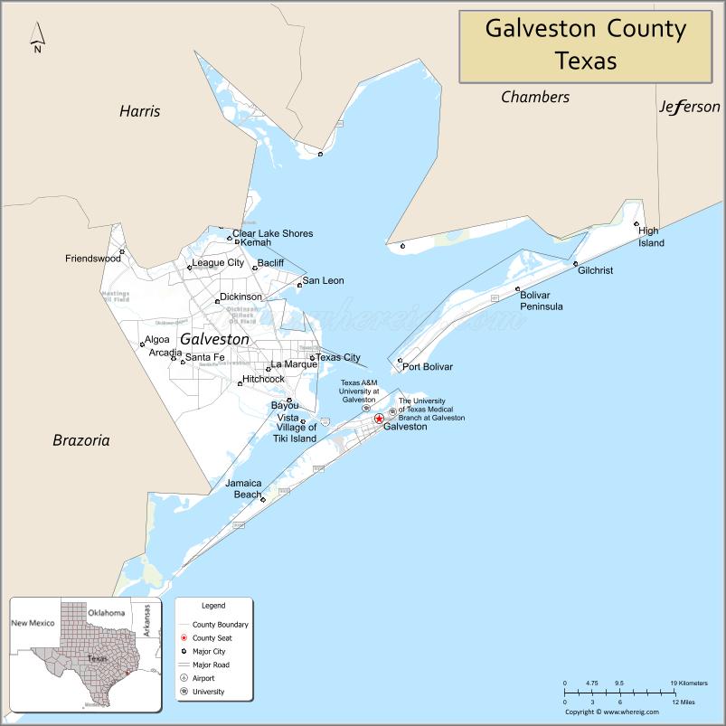
About Galveston County Map, Texas: The map showing the county boundary, county seat, major cities, highways, water bodies and neighbouring counties.
Related Texas Maps
Map of Galveston County, Texas
Galveston County is a county located in the U.S. state of Texas. It's county seat is Galveston. As per 2020 census, the population of Galveston County is 355062 people and population density is square miles. According to the United States Census Bureau, the county has a total area of 399 sq mi (1,033 km2). Galveston County was established on 1838.
Facts about Galveston County, Texas
| Country | United States |
| State | Texas |
| Region | Texas Gulf Coast / Southeast Texas |
| County Seat | Galveston |
| Named After | Bernardo de Gálvez, Spanish military and political leader |
| Established | 1838 |
| Organized | 1839 |
| Coordinates | 29.2970° N, 94.7950° W |
| Total Area | 874 sq mi |
| Land Area | 378 sq mi |
| Water Area | 496 sq mi |
| Population (2020) | 350,682 |
| Population Rank | Significant and rapidly growing coastal county |
| Major Cities | Galveston, League City (largest), Texas City, Dickinson, La Marque |
| Main Industries | Port & Shipping, Tourism, Petrochemicals, Healthcare, Education |
| Major Airport | Scholes International Airport (Galveston); Nearby: Houston Hobby (HOU) |
| Time Zone | Central Time (UTC−06:00) |
| Known For | Galveston beaches, Historic Strand District, Moody Gardens, Port of Galveston, Cruise terminals |
| Website | https://www.galvestoncountytx.gov |
Top Attractions in Galveston County, Texas
- Galveston Island Historic Pleasure Pier – Waterfront amusement rides and entertainment.
- Moody Gardens – Rainforest pyramid, aquarium, and educational exhibits.
- Galveston Seawall – Iconic coastal walkway with beaches and ocean views.
- Schlitterbahn Galveston – Waterpark with slides, rivers, and family attractions.
- The Strand Historic District – Shops, dining, and Victorian-era architecture.
- Bishop’s Palace – Ornate Victorian mansion offering guided tours.
- Galveston Island State Park – Beach and bay-side trails, bird-watching, and kayaking.
- 1877 Tall Ship ELISSA – Restored sailing vessel at the Texas Seaport Museum.
- Moody Mansion – Historic home museum showcasing early 1900s life.
- Space Center Houston (County Border Access) – NASA visitor center with interactive space exhibits.
Cities and Towns in Galveston County, Texas
| Place | Type | Population (Census 2020) | Latitude & Longitude |
|---|---|---|---|
| Galveston (county seat) | City | 53895 | 29.3013°N, 94.7977°W |
| League City | City | 114392 | 29.5075°N, 95.0949°W |
| Texas City | City | 51938 | 29.3838°N, 94.9027°W |
| Dickinson | City | 20451 | 29.4608°N, 95.0513°W |
| La Marque | City | 18168 | 29.3686°N, 94.9719°W |
| Santa Fe | City | 13524 | 29.3780°N, 95.1055°W |
| Kemah | City | 1792 | 29.5427°N, 95.0202°W |
| Jamaica Beach | City | 983 | 29.1908°N, 94.9808°W |
| Bayou Vista | City | 632 | 29.3258°N, 94.9405°W |
| Tiki Island | Village | 29.2983°N, 94.9166°W | |
| Bacliff | Census Designated Place (CDP) | 10443 | 29.5063°N, 94.9880°W |
| San Leon | Census Designated Place (CDP) | 5497 | 29.4891°N, 94.9224°W |
What are Major Roads and Highways in Galveston County
- Interstate 45 - connects Galveston Island with Houston
- Interstate 45 Business - serves downtown Galveston
- State Highway 87 - runs along the Bolivar Peninsula
- State Highway 146 - north-south route through Texas City and Kemah
- State Highway 3 - parallels Interstate 45 through mainland communities
- Farm to Market Road 1764 - major east-west corridor through Texas City and Santa Fe
- Farm to Market Road 517 - connects Dickinson, League City, and San Leon
- Seawall Boulevard - major coastal roadway along Galveston Island
What are Neighboring Counties of Galveston County
- Harris County (north)
- Chambers County (east)
- Brazoria County (west)
- Jefferson County (northeast across Galveston Bay)
Distance from Galveston County to Nearby Cities
| City | Distance (km) | Distance (mi) |
|---|---|---|
| Galveston to Texas City | 19 | 12 |
| Galveston to La Marque | 24 | 15 |
| Galveston to Dickinson | 37 | 23 |
| Galveston to League City | 43 | 27 |
| Galveston to Kemah | 48 | 30 |
| Galveston to Santa Fe | 35 | 22 |
| Galveston to Houston | 82 | 51 |
| Galveston to Baytown | 72 | 45 |
| Galveston to Freeport | 97 | 60 |
| Galveston to Beaumont | 137 | 85 |
| Galveston to College Station | 177 | 110 |
| Galveston to Victoria | 206 | 128 |
| Galveston to Austin | 346 | 215 |
| Galveston to San Antonio | 424 | 263 |
| Galveston to Dallas | 482 | 300 |
Waterbodies in Galveston County
Galveston Bay, West Bay, East Bay, Trinity Bay, Gulf of Mexico, Clear Lake, Moses Lake, Dickinson Bayou, Highland Bayou, Chocolate Bay, Offatts Bayou, Galveston Ship Channel, wetlands, tidal marshes, estuaries, lagoons, and coastal waterways
Best Golf Courses in Galveston County, Texas
| Golf Course | Location | Latitude & Longitude |
|---|---|---|
| Moody Gardens Golf Course | Galveston | 29.2728°N, 94.8517°W |
| Galveston Country Club | Galveston | 29.2439°N, 94.9392°W |
| Bayou Golf Club | Texas City | 29.3913°N, 94.9288°W |
| Beacon Lakes Golf Club | Dickinson | 29.4705°N, 95.0634°W |
| South Shore Harbour Country Club | League City | 29.5516°N, 95.0631°W |
| Magnolia Creek Golf Club | League City | 29.4862°N, 95.1173°W |
Colleges and Universities in Galveston County, Texas
| Institution Name | Type | Level | Notable For |
|---|---|---|---|
| The University of Texas Medical Branch (UTMB) | Public | University | Major medical school and health sciences center in Galveston |
| College of the Mainland | Public | Community College | Primary community college serving Galveston County |
| Texas A&M University at Galveston | Public | University | Marine and maritime-focused branch campus of Texas A&M University |
| Galveston College | Public | Community College | Associate degree and workforce training programs |
| University of Houston-Clear Lake | Public | University | Regional university serving the Bay Area and Galveston County |
References
- U.S. Census Bureau - Galveston County QuickFacts
- Official Galveston County Website
- Texas State Historical Association - Galveston County
- The University of Texas Medical Branch
- College of the Mainland
- Anderson County Map
- Andrews County Map
- Angelina County Map
- Aransas County Map
- Archer County Map
- Armstrong County Map
- Atascosa County Map
- Austin County Map
- Bailey County Map
- Bandera County Map
- Bastrop County Map
- Baylor County Map
- Bee County Map
- Bell County Map
- Bexar County Map
- Blanco County Map
- Borden County Map
- Bosque County Map
- Bowie County Map
- Brazoria County Map
- Brazos County Map
- Brewster County Map
- Briscoe County Map
- Brooks County Map
- Brown County Map
- Burleson County Map
- Burnet County Map
- Caldwell County Map
- Calhoun County Map
- Callahan County Map
- Cameron County Map
- Camp County Map
- Carson County Map
- Cass County Map
- Castro County Map
- Chambers County Map
- Cherokee County Map
- Childress County Map
- Clay County Map
- Cochran County Map
- Coke County Map
- Coleman County Map
- Collin County Map
- Collingsworth County Map
- Colorado County Map
- Comal County Map
- Comanche County Map
- Concho County Map
- Cooke County Map
- Coryell County Map
- Cottle County Map
- Crane County Map
- Crockett County Map
- Crosby County Map
- Culberson County Map
- Dallam County Map
- Dallas County Map
- Dawson County Map
- Deaf Smith County Map
- Delta County Map
- Denton County Map
- DeWitt County Map
- Dickens County Map
- Dimmit County Map
- Donley County Map
- Duval County Map
- Eastland County Map
- Ector County Map
- Edwards County Map
- Ellis County Map
- El Paso County Map
- Erath County Map
- Falls County Map
- Fannin County Map
- Fayette County Map
- Fisher County Map
- Floyd County Map
- Foard County Map
- Fort Bend County Map
- Franklin County Map
- Freestone County Map
- Frio County Map
- Gaines County Map
- Galveston County Map
- Garza County Map
- Gillespie County Map
- Glasscock County Map
- Goliad County Map
- Gonzales County Map
- Gray County Map
- Grayson County Map
- Gregg County Map
- Grimes County Map
- Guadalupe County Map
- Hale County Map
- Hall County Map
- Hamilton County Map
- Hansford County Map
- Hardeman County Map
- Hardin County Map
- Harris County Map
- Harrison County Map
- Hartley County Map
- Haskell County Map
- Hays County Map
- Hemphill County Map
- Henderson County Map
- Hidalgo County Map
- Hill County Map
- Hockley County Map
- Hood County Map
- Hopkins County Map
- Houston County Map
- Howard County Map
- Hudspeth County Map
- Hunt County Map
- Hutchinson County Map
- Irion County Map
- Jack County Map
- Jackson County Map
- Jasper County Map
- Jeff Davis County Map
- Jefferson County Map
- Jim Hogg County Map
- Jim Wells County Map
- Johnson County Map
- Jones County Map
- Karnes County Map
- Kaufman County Map
- Kendall County Map
- Kenedy County Map
- Kent County Map
- Kerr County Map
- Kimble County Map
- King County Map
- Kinney County Map
- Kleberg County Map
- Knox County Map
- Lamar County Map
- Lamb County Map
- Lampasas County Map
- La Salle County Map
- Lavaca County Map
- Lee County Map
- Leon County Map
- Liberty County Map
- Limestone County Map
- Lipscomb County Map
- Live Oak County Map
- Llano County Map
- Loving County Map
- Lubbock County Map
- Lynn County Map
- McCulloch County Map
- McLennan County Map
- McMullen County Map
- Madison County Map
- Marion County Map
- Martin County Map
- Mason County Map
- Matagorda County Map
- Maverick County Map
- Medina County Map
- Menard County Map
- Midland County Map
- Milam County Map
- Mills County Map
- Mitchell County Map
- Montague County Map
- Montgomery County Map
- Moore County Map
- Morris County Map
- Motley County Map
- Nacogdoches County Map
- Navarro County Map
- Newton County Map
- Nolan County Map
- Nueces County Map
- Ochiltree County Map
- Oldham County Map
- Orange County Map
- Palo Pinto County Map
- Panola County Map
- Parker County Map
- Parmer County Map
- Pecos County Map
- Polk County Map
- Potter County Map
- Presidio County Map
- Rains County Map
- Randall County Map
- Reagan County Map
- Real County Map
- Red River County Map
- Reeves County Map
- Refugio County Map
- Roberts County Map
- Robertson County Map
- Rockwall County Map
- Runnels County Map
- Rusk County Map
- Sabine County Map
- San Augustine County Map
- San Jacinto County Map
- San Patricio County Map
- San Saba County Map
- Schleicher County Map
- Scurry County Map
- Shackelford County Map
- Shelby County Map
- Sherman County Map
- Smith County Map
- Somervell County Map
- Starr County Map
- Stephens County Map
- Sterling County Map
- Stonewall County Map
- Sutton County Map
- Swisher County Map
- Tarrant County Map
- Taylor County Map
- Terrell County Map
- Terry County Map
- Throckmorton County Map
- Titus County Map
- Tom Green County Map
- Travis County Map
- Trinity County Map
- Tyler County Map
- Upshur County Map
- Upton County Map
- Uvalde County Map
- Val Verde County Map
- Van Zandt County Map
- Victoria County Map
- Walker County Map
- Waller County Map
- Ward County Map
- Washington County Map
- Webb County Map
- Wharton County Map
- Wheeler County Map
- Wichita County Map
- Wilbarger County Map
- Willacy County Map
- Williamson County Map
- Wilson County Map
- Winkler County Map
- Wise County Map
- Wood County Map
- Yoakum County Map
- Young County Map
- Zapata County Map
- Zavala County Map
- Alabama Counties
- Alaska boroughs
- Arizona Counties
- Arkansas Counties
- California County Map
- Colorado Counties
- Connecticut Counties
- Delaware Counties
- Florida County Map
- Georgia County Map
- Hawaii Counties
- Idaho Counties
- Illinois Counties
- Indiana Counties
- Iowa Counties
- Kansas Counties
- Kentucky Counties
- Louisiana Counties
- Maine Counties
- Maryland Counties
- Massachusetts Counties
- Michigan County Map
- Minnesota Counties
- Mississippi Counties
- Missouri Counties
- Montana Counties
- Nebraska Counties
- Nevada Counties
- New York Counties
- New Hampshire Counties
- New Jersey Counties
- New Mexico Counties
- North Carolina Counties
- North Dakota Counties
- Ohio County Map
- Oklahoma Counties
- Oregon Counties
- Pennsylvania Counties
- Rhode Island Counties
- South Carolina Counties
- South Dakota Counties
- Map of Tennessee
- Texas County Map
- Utah Counties
- Vermont Counties
- Virginia Counties
- Washington Counties
- West Virginia Counties
- Wisconsin Counties
- Wyoming Counties
References
- ^ QuickFacts: Galveston County, Texas - United States Census Bureau
- ^ United States Census Bureau - Population and Housing Data
- ^ TIGER/Line Shapefiles - United States Census Bureau
- ^ United States Geological Survey (USGS)
- ^ National Geodetic Survey (NGS), NOAA
- ^ Official Website of Galveston County, Texas
- ^ Texas Department of Transportation (TxDOT)