Map of Aransas County - Aransas County is a county located in the U.S. state of Texas. Aransas County Map showing cities, highways, important places and water bodies. Get Where is Aransas County located in the map, major cities in Aransas county, population, areas, and places of interest.
Map of Aransas County, Texas
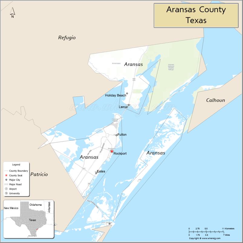
About Aransas County Map, Texas: The map showing the county boundary, county seat, major cities, highways, water bodies and neighbouring counties.
Related Texas Maps
Map of Aransas County, Texas
Aransas County is a county located in the U.S. state of Texas. It's county seat is Rockport. As per 2020 census, the population of Aransas County is 24510 people and population density is square miles. According to the United States Census Bureau, the county has a total area of 252 sq mi (653 km2). Aransas County was established on 1871.
Facts about Aransas County, Texas
| Country | United States |
| State | Texas |
| Region | Texas Gulf Coast |
| County Seat | Rockport |
| Named After | Aransas Bay |
| Established | 1871 |
| Organized | 1871 |
| Coordinates | 28.1141° N, 97.0483° W |
| Total Area | 528 sq mi |
| Land Area | 252 sq mi |
| Water Area | 276 sq mi |
| Population (2020) | 23,830 |
| Population Rank | Small coastal county |
| Major City | Rockport |
| Main Industries | Tourism, Fishing, Marine Services, Retail |
| Major Airport | Aransas County Airport |
| Time Zone | Central Time (UTC−06:00) |
| Known For | Rockport Beach, Whooping Cranes, Coastal birding, Maritime culture |
| Website | https://www.aransascounty.org |
Top Attractions in Aransas County, Texas
- Rockport Beach – Clean, calm beach great for swimming and relaxing.
- Aransas National Wildlife Refuge – Prime bird-watching spot and winter home of whooping cranes.
- Goose Island State Park – Fishing pier, coastal trails, and the famous “Big Tree.”
- Fulton Mansion State Historic Site – Restored Victorian home with coastal history exhibits.
- Texas Maritime Museum – Exhibits on Gulf Coast maritime history.
- Rockport Center for the Arts – Local art gallery and community exhibits.
- Bay Education Center – Science displays and popular “Science on a Sphere” show.
- Downtown Rockport – Shops, cafés, and local coastal charm.
- Tule Creek Hike & Bike Trail – Scenic trail for walking, biking, and wildlife viewing.
- Memorial Park (Rockport) – Large community park with sports areas and nature paths.
Cities and Towns in Aransas County, Texas
| Place | Type | Population (Census 2020) | Latitude & Longitude |
|---|---|---|---|
| Rockport (county seat) | City | 10714 | 28.0206°N, 97.0544°W |
| Fulton | Town | 1331 | 28.0617°N, 97.0414°W |
| Holiday Beach | Census Designated Place (CDP) | 1514 | 28.1266°N, 96.9928°W |
| Lamar | Census Designated Place (CDP) | 1636 | 28.0719°N, 96.9898°W |
| Estes | Unincorporated Community | N/A | 27.9768°N, 97.1024°W |
| Palm Harbor | Unincorporated Community | N/A | 27.9739°N, 97.1316°W |
What are Major Roads and Highways in Aransas County
Major highways connect the county to nearby regions and cities.
- Texas State Highway 35 - connects Rockport with Corpus Christi, Aransas Pass, Port Lavaca, and Victoria
- Texas State Highway 188 - connects Rockport with Sinton and U.S. Highway 77
- Texas State Highway 361 - connects Aransas County with Port Aransas and Mustang Island
- Farm to Market Road 1069 - serves the Fulton and Goose Island areas
- Farm to Market Road 1781 - connects central Rockport with surrounding communities
- Farm to Market Road 2165 - serves western portions of the county
- Farm to Market Road 3036 - provides access to northern Rockport and Lamar
What are Neighboring Counties of Aransas County
- Refugio County (northwest)
- Calhoun County (northeast, across Aransas Bay)
- Nueces County (south)
- San Patricio County (southwest)
Distance from Aransas County to Nearby Cities
The following distances are measured by road (driving).
- Rockport to Aransas Pass (San Patricio County), Texas - 12 mi (19 km)
- Rockport to Port Aransas (Nueces County), Texas - 20 mi (32 km)
- Rockport to Sinton (San Patricio County), Texas - 28 mi (45 km)
- Rockport to Corpus Christi (Nueces County), Texas - 31 mi (50 km)
- Rockport to Port Lavaca (Calhoun County), Texas - 55 mi (89 km)
- Rockport to Refugio (Refugio County), Texas - 37 mi (60 km)
- Rockport to Beeville (Bee County), Texas - 56 mi (90 km)
- Rockport to Victoria (Victoria County), Texas - 73 mi (117 km)
- Rockport to Kingsville (Kleberg County), Texas - 55 mi (89 km)
- Rockport to Alice (Jim Wells County), Texas - 63 mi (101 km)
- Rockport to Cuero (DeWitt County), Texas - 99 mi (159 km)
- Rockport to Houston (Harris County), Texas - 182 mi (293 km)
- Rockport to San Antonio (Bexar County), Texas - 165 mi (266 km)
- Rockport to Austin (Travis County), Texas - 206 mi (332 km)
- Rockport to Laredo (Webb County), Texas - 180 mi (290 km)
Waterbodies in Aransas County
Aransas Bay, Copano Bay, St. Charles Bay, Mesquite Bay, Redfish Bay, Gulf of Mexico, Aransas Channel, Intracoastal Waterway, Mission River estuary, Aransas River estuary, Port Bay, Salt Lake, Little Bay, Canoe Lake, Goose Island wetlands, Blackjack Peninsula marshes
Best Golf Courses in Aransas County, Texas
| Golf Course | Location | Latitude & Longitude |
|---|---|---|
| Rockport Country Club | Rockport | 28.0437°N, 97.0124°W |
Colleges and Universities in Aransas County, Texas
| Institution Name | Type | Level | Notable For |
|---|---|---|---|
| Del Mar College - Aransas County Programs | Public | Community College | Dual-credit and workforce education |
References
- U.S. Census Bureau - Aransas County QuickFacts
- Official Aransas County Website
- Texas State Historical Association - Aransas County
- Aransas County Economic Development Corporation - Education
- Texas Department of Transportation
- Anderson County Map
- Andrews County Map
- Angelina County Map
- Aransas County Map
- Archer County Map
- Armstrong County Map
- Atascosa County Map
- Austin County Map
- Bailey County Map
- Bandera County Map
- Bastrop County Map
- Baylor County Map
- Bee County Map
- Bell County Map
- Bexar County Map
- Blanco County Map
- Borden County Map
- Bosque County Map
- Bowie County Map
- Brazoria County Map
- Brazos County Map
- Brewster County Map
- Briscoe County Map
- Brooks County Map
- Brown County Map
- Burleson County Map
- Burnet County Map
- Caldwell County Map
- Calhoun County Map
- Callahan County Map
- Cameron County Map
- Camp County Map
- Carson County Map
- Cass County Map
- Castro County Map
- Chambers County Map
- Cherokee County Map
- Childress County Map
- Clay County Map
- Cochran County Map
- Coke County Map
- Coleman County Map
- Collin County Map
- Collingsworth County Map
- Colorado County Map
- Comal County Map
- Comanche County Map
- Concho County Map
- Cooke County Map
- Coryell County Map
- Cottle County Map
- Crane County Map
- Crockett County Map
- Crosby County Map
- Culberson County Map
- Dallam County Map
- Dallas County Map
- Dawson County Map
- Deaf Smith County Map
- Delta County Map
- Denton County Map
- DeWitt County Map
- Dickens County Map
- Dimmit County Map
- Donley County Map
- Duval County Map
- Eastland County Map
- Ector County Map
- Edwards County Map
- Ellis County Map
- El Paso County Map
- Erath County Map
- Falls County Map
- Fannin County Map
- Fayette County Map
- Fisher County Map
- Floyd County Map
- Foard County Map
- Fort Bend County Map
- Franklin County Map
- Freestone County Map
- Frio County Map
- Gaines County Map
- Galveston County Map
- Garza County Map
- Gillespie County Map
- Glasscock County Map
- Goliad County Map
- Gonzales County Map
- Gray County Map
- Grayson County Map
- Gregg County Map
- Grimes County Map
- Guadalupe County Map
- Hale County Map
- Hall County Map
- Hamilton County Map
- Hansford County Map
- Hardeman County Map
- Hardin County Map
- Harris County Map
- Harrison County Map
- Hartley County Map
- Haskell County Map
- Hays County Map
- Hemphill County Map
- Henderson County Map
- Hidalgo County Map
- Hill County Map
- Hockley County Map
- Hood County Map
- Hopkins County Map
- Houston County Map
- Howard County Map
- Hudspeth County Map
- Hunt County Map
- Hutchinson County Map
- Irion County Map
- Jack County Map
- Jackson County Map
- Jasper County Map
- Jeff Davis County Map
- Jefferson County Map
- Jim Hogg County Map
- Jim Wells County Map
- Johnson County Map
- Jones County Map
- Karnes County Map
- Kaufman County Map
- Kendall County Map
- Kenedy County Map
- Kent County Map
- Kerr County Map
- Kimble County Map
- King County Map
- Kinney County Map
- Kleberg County Map
- Knox County Map
- Lamar County Map
- Lamb County Map
- Lampasas County Map
- La Salle County Map
- Lavaca County Map
- Lee County Map
- Leon County Map
- Liberty County Map
- Limestone County Map
- Lipscomb County Map
- Live Oak County Map
- Llano County Map
- Loving County Map
- Lubbock County Map
- Lynn County Map
- McCulloch County Map
- McLennan County Map
- McMullen County Map
- Madison County Map
- Marion County Map
- Martin County Map
- Mason County Map
- Matagorda County Map
- Maverick County Map
- Medina County Map
- Menard County Map
- Midland County Map
- Milam County Map
- Mills County Map
- Mitchell County Map
- Montague County Map
- Montgomery County Map
- Moore County Map
- Morris County Map
- Motley County Map
- Nacogdoches County Map
- Navarro County Map
- Newton County Map
- Nolan County Map
- Nueces County Map
- Ochiltree County Map
- Oldham County Map
- Orange County Map
- Palo Pinto County Map
- Panola County Map
- Parker County Map
- Parmer County Map
- Pecos County Map
- Polk County Map
- Potter County Map
- Presidio County Map
- Rains County Map
- Randall County Map
- Reagan County Map
- Real County Map
- Red River County Map
- Reeves County Map
- Refugio County Map
- Roberts County Map
- Robertson County Map
- Rockwall County Map
- Runnels County Map
- Rusk County Map
- Sabine County Map
- San Augustine County Map
- San Jacinto County Map
- San Patricio County Map
- San Saba County Map
- Schleicher County Map
- Scurry County Map
- Shackelford County Map
- Shelby County Map
- Sherman County Map
- Smith County Map
- Somervell County Map
- Starr County Map
- Stephens County Map
- Sterling County Map
- Stonewall County Map
- Sutton County Map
- Swisher County Map
- Tarrant County Map
- Taylor County Map
- Terrell County Map
- Terry County Map
- Throckmorton County Map
- Titus County Map
- Tom Green County Map
- Travis County Map
- Trinity County Map
- Tyler County Map
- Upshur County Map
- Upton County Map
- Uvalde County Map
- Val Verde County Map
- Van Zandt County Map
- Victoria County Map
- Walker County Map
- Waller County Map
- Ward County Map
- Washington County Map
- Webb County Map
- Wharton County Map
- Wheeler County Map
- Wichita County Map
- Wilbarger County Map
- Willacy County Map
- Williamson County Map
- Wilson County Map
- Winkler County Map
- Wise County Map
- Wood County Map
- Yoakum County Map
- Young County Map
- Zapata County Map
- Zavala County Map
- Alabama Counties
- Alaska boroughs
- Arizona Counties
- Arkansas Counties
- California County Map
- Colorado Counties
- Connecticut Counties
- Delaware Counties
- Florida County Map
- Georgia County Map
- Hawaii Counties
- Idaho Counties
- Illinois Counties
- Indiana Counties
- Iowa Counties
- Kansas Counties
- Kentucky Counties
- Louisiana Counties
- Maine Counties
- Maryland Counties
- Massachusetts Counties
- Michigan County Map
- Minnesota Counties
- Mississippi Counties
- Missouri Counties
- Montana Counties
- Nebraska Counties
- Nevada Counties
- New York Counties
- New Hampshire Counties
- New Jersey Counties
- New Mexico Counties
- North Carolina Counties
- North Dakota Counties
- Ohio County Map
- Oklahoma Counties
- Oregon Counties
- Pennsylvania Counties
- Rhode Island Counties
- South Carolina Counties
- South Dakota Counties
- Map of Tennessee
- Texas County Map
- Utah Counties
- Vermont Counties
- Virginia Counties
- Washington Counties
- West Virginia Counties
- Wisconsin Counties
- Wyoming Counties
References
- ^ QuickFacts: Aransas County, Texas - United States Census Bureau
- ^ United States Census Bureau - Population and Housing Data
- ^ TIGER/Line Shapefiles - United States Census Bureau
- ^ United States Geological Survey (USGS)
- ^ National Geodetic Survey (NGS), NOAA
- ^ Official Website of Aransas County, Texas
- ^ Texas Department of Transportation (TxDOT)