Map of Brooks County - Brooks County is a county located in the U.S. state of Texas. Brooks County Map showing cities, highways, important places and water bodies. Get Where is Brooks County located in the map, major cities in Brooks county, population, areas, and places of interest.
Map of Brooks County, Texas
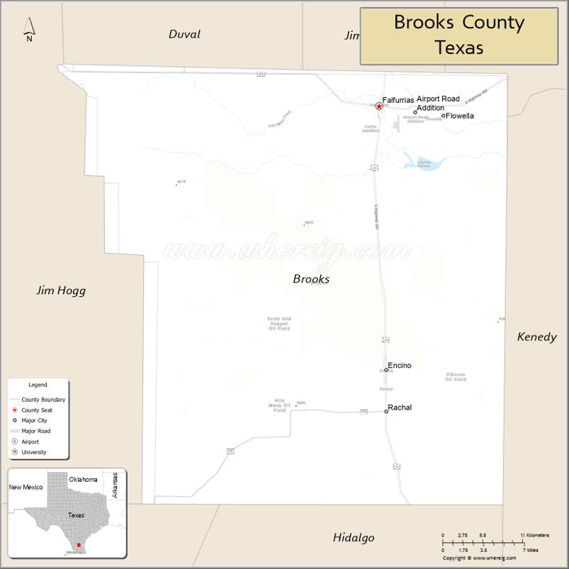
About Brooks County Map, Texas: The map showing the county boundary, county seat, major cities, highways, water bodies and neighbouring counties.
Related Texas Maps
Map of Brooks County, Texas
Brooks County is a county located in the U.S. state of Texas. It's county seat is Falfurrias. As per 2020 census, the population of Brooks County is 6994 people and population density is square miles. According to the United States Census Bureau, the county has a total area of 943 sq mi (2,442 km2). Brooks County was established on 1911.
Facts about Brooks County, Texas
| Country | United States |
| State | Texas |
| Region | South Texas |
| County Seat | Falfurrias |
| Named After | James Abijah Brooks |
| Established | 1911 |
| Organized | 1911 |
| Coordinates | 27.0260° N, 98.2364° W |
| Total Area | 944 sq mi |
| Land Area | 943 sq mi |
| Water Area | 1 sq mi |
| Population (2020) | 7,076 |
| Population Rank | Sparsely populated South Texas county |
| Major City | Falfurrias |
| Main Industries | Ranching, Agriculture, Border security operations |
| Major Airport | Falfurrias Border Patrol Airport (general aviation) |
| Time Zone | Central Time (UTC−06:00) |
| Known For | Border Patrol checkpoint, Ranching heritage, South Texas brush country |
| Website | https://www.co.brooks.tx.us |
Top Attractions in Brooks County, Texas
- Falfurrias Heritage Museum – Exhibits on local ranching, history, and early settlers.
- Falfurrias Butter & Dairy History Displays – Tributes to the county’s famous dairy legacy.
- Sacred Heart Catholic Church – Historic church with notable architecture.
- Los Olmos Creek Area – Quiet natural spot for wildlife viewing and photography.
- Brooks County Courthouse – Landmark courthouse anchoring downtown Falfurrias.
- Blucher Park (Nearby in Kingsville Region) – Birding location often visited by locals.
- Don Pedrito Jaramillo Shrine – Site honoring the folk healer known as the “Healer of Los Olmos.”
- Falfurrias Golf Course – Local 9-hole course for casual play.
- Downtown Falfurrias – Small shops, cafés, and local charm.
- South Texas Ranchlands – Scenic drives through brush country landscapes.
Cities and Towns in Brooks County, Texas
| Place | Type | Population (Census 2020) | Latitude & Longitude |
|---|---|---|---|
| Falfurrias (county seat) | City | 4609 | 27.2269°N, 98.1442°W |
| Airport Road Addition | Census Designated Place (CDP) | 93 | 27.2097°N, 98.1216°W |
| Cantu Addition | Census Designated Place (CDP) | 191 | 27.2020°N, 98.1539°W |
| Encino | Census Designated Place (CDP) | 109 | 26.9365°N, 98.1384°W |
| Flowella | Census Designated Place (CDP) | 117 | 27.2194°N, 98.0808°W |
| Rachal | Unincorporated Community | N/A | 27.3014°N, 98.0292°W |
What are Major Roads and Highways in Brooks County
Major highways connect the county to nearby regions and cities.
- U.S. Highway 281 (Future I-69C) - north toward George West and south toward McAllen
- Texas State Highway 285 - west toward Hebbronville and east toward Riviera
- Farm to Market Road 755 - connects rural ranchlands in western Brooks County
- Farm to Market Road 1418 - serves agricultural and ranching areas east of Falfurrias
- Farm to Market Road 2191 - links local communities with U.S. Highway 281
What are Neighboring Counties of Brooks County
- Jim Wells County (north)
- Kenedy County (east)
- Hidalgo County (south)
- Starr County (southwest)
- Jim Hogg County (west)
Distance from Brooks County to Nearby Cities
The following distances are measured by road (driving).
- Falfurrias to Encino (Brooks County), Texas - 18 mi (29 km)
- Falfurrias to Alice (Jim Wells County), Texas - 42 mi (68 km)
- Falfurrias to Hebbronville (Jim Hogg County), Texas - 41 mi (66 km)
- Falfurrias to Raymondville (Willacy County), Texas - 52 mi (84 km)
- Falfurrias to Edinburg (Hidalgo County), Texas - 79 mi (127 km)
- Falfurrias to McAllen (Hidalgo County), Texas - 89 mi (143 km)
- Falfurrias to Mission (Hidalgo County), Texas - 92 mi (148 km)
- Falfurrias to Kingsville (Kleberg County), Texas - 55 mi (89 km)
- Falfurrias to Harlingen (Cameron County), Texas - 92 mi (148 km)
- Falfurrias to Brownsville (Cameron County), Texas - 112 mi (180 km)
- Falfurrias to Corpus Christi (Nueces County), Texas - 86 mi (138 km)
- Falfurrias to Laredo (Webb County), Texas - 116 mi (187 km)
- Falfurrias to Rio Grande City (Starr County), Texas - 67 mi (108 km)
- Falfurrias to San Benito (Cameron County), Texas - 98 mi (158 km)
- Falfurrias to San Antonio (Bexar County), Texas - 173 mi (278 km)
Waterbodies in Brooks County
Baluarte Creek, Palo Blanco Creek, Laguna Salada, Petronila Creek watershed, San Fernando Creek tributaries, Chiltipin Creek, Palo Blanco Lake, ranch reservoirs, stock ponds, seasonal wetlands, playa basins, drainage canals, ephemeral streams, and South Texas brush country watersheds
Best Golf Courses in Brooks County, Texas
| Golf Course | Location | Latitude & Longitude |
|---|---|---|
| Falfurrias Golf Course | Falfurrias | 27.2378°N, 98.1598°W |
Colleges and Universities in Brooks County, Texas
| Institution Name | Type | Level | Notable For |
|---|---|---|---|
| Coastal Bend College | Public | Community College | Designated community college serving the county |
| Texas A&M AgriLife Extension Service - Brooks County | Public | University | Agricultural education and outreach programs |
References
- U.S. Census Bureau - Brooks County QuickFacts
- Official Brooks County Website
- Texas State Historical Association - Brooks County
- Coastal Bend College
- U.S. Geological Survey (GNIS)
- Anderson County Map
- Andrews County Map
- Angelina County Map
- Aransas County Map
- Archer County Map
- Armstrong County Map
- Atascosa County Map
- Austin County Map
- Bailey County Map
- Bandera County Map
- Bastrop County Map
- Baylor County Map
- Bee County Map
- Bell County Map
- Bexar County Map
- Blanco County Map
- Borden County Map
- Bosque County Map
- Bowie County Map
- Brazoria County Map
- Brazos County Map
- Brewster County Map
- Briscoe County Map
- Brooks County Map
- Brown County Map
- Burleson County Map
- Burnet County Map
- Caldwell County Map
- Calhoun County Map
- Callahan County Map
- Cameron County Map
- Camp County Map
- Carson County Map
- Cass County Map
- Castro County Map
- Chambers County Map
- Cherokee County Map
- Childress County Map
- Clay County Map
- Cochran County Map
- Coke County Map
- Coleman County Map
- Collin County Map
- Collingsworth County Map
- Colorado County Map
- Comal County Map
- Comanche County Map
- Concho County Map
- Cooke County Map
- Coryell County Map
- Cottle County Map
- Crane County Map
- Crockett County Map
- Crosby County Map
- Culberson County Map
- Dallam County Map
- Dallas County Map
- Dawson County Map
- Deaf Smith County Map
- Delta County Map
- Denton County Map
- DeWitt County Map
- Dickens County Map
- Dimmit County Map
- Donley County Map
- Duval County Map
- Eastland County Map
- Ector County Map
- Edwards County Map
- Ellis County Map
- El Paso County Map
- Erath County Map
- Falls County Map
- Fannin County Map
- Fayette County Map
- Fisher County Map
- Floyd County Map
- Foard County Map
- Fort Bend County Map
- Franklin County Map
- Freestone County Map
- Frio County Map
- Gaines County Map
- Galveston County Map
- Garza County Map
- Gillespie County Map
- Glasscock County Map
- Goliad County Map
- Gonzales County Map
- Gray County Map
- Grayson County Map
- Gregg County Map
- Grimes County Map
- Guadalupe County Map
- Hale County Map
- Hall County Map
- Hamilton County Map
- Hansford County Map
- Hardeman County Map
- Hardin County Map
- Harris County Map
- Harrison County Map
- Hartley County Map
- Haskell County Map
- Hays County Map
- Hemphill County Map
- Henderson County Map
- Hidalgo County Map
- Hill County Map
- Hockley County Map
- Hood County Map
- Hopkins County Map
- Houston County Map
- Howard County Map
- Hudspeth County Map
- Hunt County Map
- Hutchinson County Map
- Irion County Map
- Jack County Map
- Jackson County Map
- Jasper County Map
- Jeff Davis County Map
- Jefferson County Map
- Jim Hogg County Map
- Jim Wells County Map
- Johnson County Map
- Jones County Map
- Karnes County Map
- Kaufman County Map
- Kendall County Map
- Kenedy County Map
- Kent County Map
- Kerr County Map
- Kimble County Map
- King County Map
- Kinney County Map
- Kleberg County Map
- Knox County Map
- Lamar County Map
- Lamb County Map
- Lampasas County Map
- La Salle County Map
- Lavaca County Map
- Lee County Map
- Leon County Map
- Liberty County Map
- Limestone County Map
- Lipscomb County Map
- Live Oak County Map
- Llano County Map
- Loving County Map
- Lubbock County Map
- Lynn County Map
- McCulloch County Map
- McLennan County Map
- McMullen County Map
- Madison County Map
- Marion County Map
- Martin County Map
- Mason County Map
- Matagorda County Map
- Maverick County Map
- Medina County Map
- Menard County Map
- Midland County Map
- Milam County Map
- Mills County Map
- Mitchell County Map
- Montague County Map
- Montgomery County Map
- Moore County Map
- Morris County Map
- Motley County Map
- Nacogdoches County Map
- Navarro County Map
- Newton County Map
- Nolan County Map
- Nueces County Map
- Ochiltree County Map
- Oldham County Map
- Orange County Map
- Palo Pinto County Map
- Panola County Map
- Parker County Map
- Parmer County Map
- Pecos County Map
- Polk County Map
- Potter County Map
- Presidio County Map
- Rains County Map
- Randall County Map
- Reagan County Map
- Real County Map
- Red River County Map
- Reeves County Map
- Refugio County Map
- Roberts County Map
- Robertson County Map
- Rockwall County Map
- Runnels County Map
- Rusk County Map
- Sabine County Map
- San Augustine County Map
- San Jacinto County Map
- San Patricio County Map
- San Saba County Map
- Schleicher County Map
- Scurry County Map
- Shackelford County Map
- Shelby County Map
- Sherman County Map
- Smith County Map
- Somervell County Map
- Starr County Map
- Stephens County Map
- Sterling County Map
- Stonewall County Map
- Sutton County Map
- Swisher County Map
- Tarrant County Map
- Taylor County Map
- Terrell County Map
- Terry County Map
- Throckmorton County Map
- Titus County Map
- Tom Green County Map
- Travis County Map
- Trinity County Map
- Tyler County Map
- Upshur County Map
- Upton County Map
- Uvalde County Map
- Val Verde County Map
- Van Zandt County Map
- Victoria County Map
- Walker County Map
- Waller County Map
- Ward County Map
- Washington County Map
- Webb County Map
- Wharton County Map
- Wheeler County Map
- Wichita County Map
- Wilbarger County Map
- Willacy County Map
- Williamson County Map
- Wilson County Map
- Winkler County Map
- Wise County Map
- Wood County Map
- Yoakum County Map
- Young County Map
- Zapata County Map
- Zavala County Map
- Alabama Counties
- Alaska boroughs
- Arizona Counties
- Arkansas Counties
- California County Map
- Colorado Counties
- Connecticut Counties
- Delaware Counties
- Florida County Map
- Georgia County Map
- Hawaii Counties
- Idaho Counties
- Illinois Counties
- Indiana Counties
- Iowa Counties
- Kansas Counties
- Kentucky Counties
- Louisiana Counties
- Maine Counties
- Maryland Counties
- Massachusetts Counties
- Michigan County Map
- Minnesota Counties
- Mississippi Counties
- Missouri Counties
- Montana Counties
- Nebraska Counties
- Nevada Counties
- New York Counties
- New Hampshire Counties
- New Jersey Counties
- New Mexico Counties
- North Carolina Counties
- North Dakota Counties
- Ohio County Map
- Oklahoma Counties
- Oregon Counties
- Pennsylvania Counties
- Rhode Island Counties
- South Carolina Counties
- South Dakota Counties
- Map of Tennessee
- Texas County Map
- Utah Counties
- Vermont Counties
- Virginia Counties
- Washington Counties
- West Virginia Counties
- Wisconsin Counties
- Wyoming Counties
References
- ^ QuickFacts: Brooks County, Texas - United States Census Bureau
- ^ United States Census Bureau - Population and Housing Data
- ^ TIGER/Line Shapefiles - United States Census Bureau
- ^ United States Geological Survey (USGS)
- ^ National Geodetic Survey (NGS), NOAA
- ^ Official Website of Brooks County, Texas
- ^ Texas Department of Transportation (TxDOT)