Map of Fort Bend County - Fort Bend County is a county located in the U.S. state of Texas. Fort Bend County Map showing cities, highways, important places and water bodies. Get Where is Fort Bend County located in the map, major cities in Fort Bend county, population, areas, and places of interest.
Map of Fort Bend County, Texas
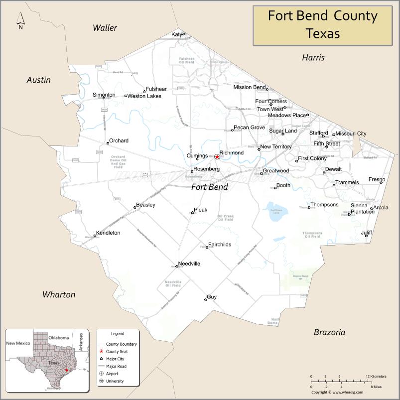
About Fort Bend County Map, Texas: The map showing the county boundary, county seat, major cities, highways, water bodies and neighbouring counties.
Related Texas Maps
Map of Fort Bend County, Texas
Fort Bend County is a county located in the U.S. state of Texas. It's county seat is Richmond. As per 2020 census, the population of Fort Bend County is 858527 people and population density is square miles. According to the United States Census Bureau, the county has a total area of 875 sq mi (2,266 km2). Fort Bend County was established on 1837.
Facts about Fort Bend County, Texas
| Country | United States |
| State | Texas |
| Region | Southeast Texas / Greater Houston Area |
| County Seat | Richmond |
| Named After | A bend in the Brazos River where a fort was built in 1822 |
| Established | 1837 |
| Organized | 1838 |
| Coordinates | 29.5280° N, 95.7700° W |
| Total Area | 885 sq mi |
| Land Area | 862 sq mi |
| Water Area | 23 sq mi |
| Population (2020) | 822,779 |
| Population Rank | Fast-growing, highly diverse county—one of the largest in Texas |
| Major Cities | Sugar Land, Missouri City, Rosenberg, Richmond, Katy (part) |
| Main Industries | Energy, Healthcare, Technology, Logistics, Education |
| Major Airport | Nearby: George Bush Intercontinental Airport (IAH) & William P. Hobby Airport (HOU) |
| Time Zone | Central Time (UTC−06:00) |
| Known For | Sugar Land Town Square, Brazos Bend State Park, Cultural diversity, Master-planned communities |
| Website | https://www.fortbendcountytx.gov |
Top Attractions in Fort Bend County, Texas
- George Ranch Historical Park – Living history site with 1800s–1900s Texas ranch life.
- Brazos Bend State Park – Alligator sightings, lakes, nature trails, and observatory.
- Fort Bend Museum (Richmond) – Exhibits on regional history and early Texas life.
- Sugar Land Town Square – Dining, shopping, events, and entertainment.
- Constellation Field – Stadium hosting baseball games and seasonal attractions.
- Houston Museum of Natural Science at Sugar Land – Dinosaur exhibits, planetarium, and science displays.
- Historic Richmond District – Local shops, heritage buildings, and cultural sites.
- First Colony Mall (Sugar Land) – Major retail center with dining and entertainment.
- Imperial Sugar Factory Site – Landmark tied to the area’s sugar-producing history.
- Seabourne Creek Nature Park (Rosenberg) – Bird-watching, trails, and serene natural spaces.
Cities and Towns in Fort Bend County, Texas
| Place | Type | Population (Census 2020) | Latitude & Longitude |
|---|---|---|---|
| Sugar Land | City | 111026 | 29.6197°N, 95.6349°W |
| Missouri City | City | 74259 | 29.6186°N, 95.5377°W |
| Rosenberg | City | 38682 | 29.5572°N, 95.8086°W |
| Richmond (county seat) | City | 11993 | 29.5822°N, 95.7608°W |
| Fulshear | City | 16403 | 29.6938°N, 95.8994°W |
| Stafford | City | 17493 | 29.6161°N, 95.5577°W |
| Meadows Place | City | 4667 | 29.6511°N, 95.5880°W |
| Katy (partly in Fort Bend County) | City | 21194 | 29.7858°N, 95.8245°W |
| Pearland (partly in Fort Bend County) | City | 125828 | 29.5636°N, 95.2860°W |
| Sienna | Census Designated Place (CDP) | 20204 | 29.4867°N, 95.5080°W |
| Mission Bend | Census Designated Place (CDP) | 36914 | 29.6930°N, 95.6649°W |
| Four Corners | Census Designated Place (CDP) | 12103 | 29.6728°N, 95.7402°W |
What are Major Roads and Highways in Fort Bend County
- Interstate 69 / U.S. Highway 59 - major route connecting Houston, Sugar Land, Richmond, and Rosenberg
- Interstate 10 - passes through northern Fort Bend County near Katy
- U.S. Highway 90 Alternate - serves Sugar Land, Stafford, Richmond, and Rosenberg
- Texas State Highway 6 - north-south corridor through Missouri City and Sugar Land
- Texas State Highway 36 - connects Rosenberg, Richmond, and Brazoria County
- Texas State Highway 99 (Grand Parkway) - major beltway serving Katy, Fulshear, and western Fort Bend County
- Westpark Tollway - connects Houston with Fulshear and western county communities
- Farm to Market Road 1093 - major transportation corridor through the county's western growth areas
What are Neighboring Counties of Fort Bend County
- Waller County (north)
- Harris County (northeast)
- Brazoria County (east)
- Wharton County (south)
- Austin County (west)
Distance from Fort Bend County to Nearby Cities
| City | Distance (km) | Distance (mi) |
|---|---|---|
| Sugar Land to Richmond | 15 | 9 |
| Sugar Land to Rosenberg | 19 | 12 |
| Sugar Land to Missouri City | 8 | 5 |
| Sugar Land to Stafford | 6 | 4 |
| Sugar Land to Fulshear | 26 | 16 |
| Richmond to Katy | 32 | 20 |
| Richmond to Houston | 48 | 30 |
| Richmond to Pearland | 50 | 31 |
| Richmond to Wharton | 58 | 36 |
| Richmond to Columbus | 74 | 46 |
| Richmond to Bay City | 92 | 57 |
| Richmond to Galveston | 110 | 68 |
| Richmond to College Station | 134 | 83 |
| Richmond to Austin | 233 | 145 |
| Richmond to San Antonio | 308 | 191 |
Waterbodies in Fort Bend County
Brazos River, Oyster Creek, Buffalo Bayou tributaries, Big Creek, Dry Creek, Jones Creek, Clear Creek, Bessie Creek, New Territory lakes, Cullinan Park lakes, Barker Reservoir tributaries, irrigation canals, wetlands, detention lakes, stock ponds, and flood-control waterways
Best Golf Courses in Fort Bend County, Texas
| Golf Course | Location | Latitude & Longitude |
|---|---|---|
| Sweetwater Country Club | Sugar Land | 29.6118°N, 95.6306°W |
| Sugar Creek Country Club | Sugar Land | 29.6204°N, 95.5948°W |
| Pecan Grove Plantation Country Club | Richmond | 29.6221°N, 95.7312°W |
| Riverbend Country Club | Sugar Land | 29.6395°N, 95.6394°W |
| Weston Lakes Country Club | Fulshear | 29.6918°N, 95.9615°W |
| Greatwood Golf Club | Sugar Land | 29.5554°N, 95.6832°W |
Colleges and Universities in Fort Bend County, Texas
| Institution Name | Type | Level | Notable For |
|---|---|---|---|
| University of Houston at Sugar Land | Public | University | Branch campus offering undergraduate and graduate programs |
| Wharton County Junior College - Sugar Land Campus | Public | Community College | Major community college serving Fort Bend County |
| Houston Community College - Stafford Campus | Public | Community College | Workforce and transfer education programs |
| Texas State Technical College - Fort Bend Center | Public | Technical College | Technical and workforce training programs |
| Texas A&M AgriLife Extension Service - Fort Bend County | Public | University | Agricultural and community education programs |
References
- U.S. Census Bureau - Fort Bend County QuickFacts
- Official Fort Bend County Website
- Texas State Historical Association - Fort Bend County
- Fort Bend County Geography and Communities
- Fort Bend County Cities and Towns
Sources: Fort Bend County had a population of 822,779 in the 2020 Census, making it one of the fastest-growing and most populous counties in Texas. Richmond is the county seat, while Sugar Land is the largest city located entirely within the county. :contentReference[oaicite:0]{index=0}
- Anderson County Map
- Andrews County Map
- Angelina County Map
- Aransas County Map
- Archer County Map
- Armstrong County Map
- Atascosa County Map
- Austin County Map
- Bailey County Map
- Bandera County Map
- Bastrop County Map
- Baylor County Map
- Bee County Map
- Bell County Map
- Bexar County Map
- Blanco County Map
- Borden County Map
- Bosque County Map
- Bowie County Map
- Brazoria County Map
- Brazos County Map
- Brewster County Map
- Briscoe County Map
- Brooks County Map
- Brown County Map
- Burleson County Map
- Burnet County Map
- Caldwell County Map
- Calhoun County Map
- Callahan County Map
- Cameron County Map
- Camp County Map
- Carson County Map
- Cass County Map
- Castro County Map
- Chambers County Map
- Cherokee County Map
- Childress County Map
- Clay County Map
- Cochran County Map
- Coke County Map
- Coleman County Map
- Collin County Map
- Collingsworth County Map
- Colorado County Map
- Comal County Map
- Comanche County Map
- Concho County Map
- Cooke County Map
- Coryell County Map
- Cottle County Map
- Crane County Map
- Crockett County Map
- Crosby County Map
- Culberson County Map
- Dallam County Map
- Dallas County Map
- Dawson County Map
- Deaf Smith County Map
- Delta County Map
- Denton County Map
- DeWitt County Map
- Dickens County Map
- Dimmit County Map
- Donley County Map
- Duval County Map
- Eastland County Map
- Ector County Map
- Edwards County Map
- Ellis County Map
- El Paso County Map
- Erath County Map
- Falls County Map
- Fannin County Map
- Fayette County Map
- Fisher County Map
- Floyd County Map
- Foard County Map
- Fort Bend County Map
- Franklin County Map
- Freestone County Map
- Frio County Map
- Gaines County Map
- Galveston County Map
- Garza County Map
- Gillespie County Map
- Glasscock County Map
- Goliad County Map
- Gonzales County Map
- Gray County Map
- Grayson County Map
- Gregg County Map
- Grimes County Map
- Guadalupe County Map
- Hale County Map
- Hall County Map
- Hamilton County Map
- Hansford County Map
- Hardeman County Map
- Hardin County Map
- Harris County Map
- Harrison County Map
- Hartley County Map
- Haskell County Map
- Hays County Map
- Hemphill County Map
- Henderson County Map
- Hidalgo County Map
- Hill County Map
- Hockley County Map
- Hood County Map
- Hopkins County Map
- Houston County Map
- Howard County Map
- Hudspeth County Map
- Hunt County Map
- Hutchinson County Map
- Irion County Map
- Jack County Map
- Jackson County Map
- Jasper County Map
- Jeff Davis County Map
- Jefferson County Map
- Jim Hogg County Map
- Jim Wells County Map
- Johnson County Map
- Jones County Map
- Karnes County Map
- Kaufman County Map
- Kendall County Map
- Kenedy County Map
- Kent County Map
- Kerr County Map
- Kimble County Map
- King County Map
- Kinney County Map
- Kleberg County Map
- Knox County Map
- Lamar County Map
- Lamb County Map
- Lampasas County Map
- La Salle County Map
- Lavaca County Map
- Lee County Map
- Leon County Map
- Liberty County Map
- Limestone County Map
- Lipscomb County Map
- Live Oak County Map
- Llano County Map
- Loving County Map
- Lubbock County Map
- Lynn County Map
- McCulloch County Map
- McLennan County Map
- McMullen County Map
- Madison County Map
- Marion County Map
- Martin County Map
- Mason County Map
- Matagorda County Map
- Maverick County Map
- Medina County Map
- Menard County Map
- Midland County Map
- Milam County Map
- Mills County Map
- Mitchell County Map
- Montague County Map
- Montgomery County Map
- Moore County Map
- Morris County Map
- Motley County Map
- Nacogdoches County Map
- Navarro County Map
- Newton County Map
- Nolan County Map
- Nueces County Map
- Ochiltree County Map
- Oldham County Map
- Orange County Map
- Palo Pinto County Map
- Panola County Map
- Parker County Map
- Parmer County Map
- Pecos County Map
- Polk County Map
- Potter County Map
- Presidio County Map
- Rains County Map
- Randall County Map
- Reagan County Map
- Real County Map
- Red River County Map
- Reeves County Map
- Refugio County Map
- Roberts County Map
- Robertson County Map
- Rockwall County Map
- Runnels County Map
- Rusk County Map
- Sabine County Map
- San Augustine County Map
- San Jacinto County Map
- San Patricio County Map
- San Saba County Map
- Schleicher County Map
- Scurry County Map
- Shackelford County Map
- Shelby County Map
- Sherman County Map
- Smith County Map
- Somervell County Map
- Starr County Map
- Stephens County Map
- Sterling County Map
- Stonewall County Map
- Sutton County Map
- Swisher County Map
- Tarrant County Map
- Taylor County Map
- Terrell County Map
- Terry County Map
- Throckmorton County Map
- Titus County Map
- Tom Green County Map
- Travis County Map
- Trinity County Map
- Tyler County Map
- Upshur County Map
- Upton County Map
- Uvalde County Map
- Val Verde County Map
- Van Zandt County Map
- Victoria County Map
- Walker County Map
- Waller County Map
- Ward County Map
- Washington County Map
- Webb County Map
- Wharton County Map
- Wheeler County Map
- Wichita County Map
- Wilbarger County Map
- Willacy County Map
- Williamson County Map
- Wilson County Map
- Winkler County Map
- Wise County Map
- Wood County Map
- Yoakum County Map
- Young County Map
- Zapata County Map
- Zavala County Map
- Alabama Counties
- Alaska boroughs
- Arizona Counties
- Arkansas Counties
- California County Map
- Colorado Counties
- Connecticut Counties
- Delaware Counties
- Florida County Map
- Georgia County Map
- Hawaii Counties
- Idaho Counties
- Illinois Counties
- Indiana Counties
- Iowa Counties
- Kansas Counties
- Kentucky Counties
- Louisiana Counties
- Maine Counties
- Maryland Counties
- Massachusetts Counties
- Michigan County Map
- Minnesota Counties
- Mississippi Counties
- Missouri Counties
- Montana Counties
- Nebraska Counties
- Nevada Counties
- New York Counties
- New Hampshire Counties
- New Jersey Counties
- New Mexico Counties
- North Carolina Counties
- North Dakota Counties
- Ohio County Map
- Oklahoma Counties
- Oregon Counties
- Pennsylvania Counties
- Rhode Island Counties
- South Carolina Counties
- South Dakota Counties
- Map of Tennessee
- Texas County Map
- Utah Counties
- Vermont Counties
- Virginia Counties
- Washington Counties
- West Virginia Counties
- Wisconsin Counties
- Wyoming Counties
References
- ^ QuickFacts: Fort Bend County, Texas - United States Census Bureau
- ^ United States Census Bureau - Population and Housing Data
- ^ TIGER/Line Shapefiles - United States Census Bureau
- ^ United States Geological Survey (USGS)
- ^ National Geodetic Survey (NGS), NOAA
- ^ Official Website of Fort Bend County, Texas
- ^ Texas Department of Transportation (TxDOT)