Map of Tom Green County - Tom Green County is a county located in the U.S. state of Texas. Tom Green County Map showing cities, highways, important places and water bodies. Get Where is Tom Green County located in the map, major cities in Tom Green county, population, areas, and places of interest.
Map of Tom Green County, Texas
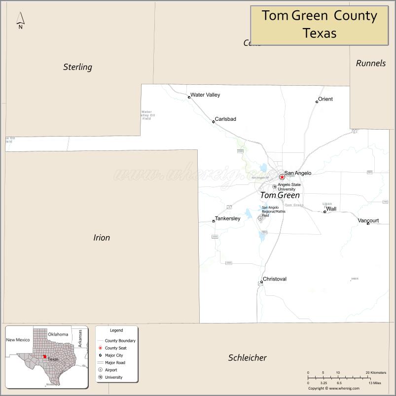
About Tom Green County Map, Texas: The map showing the county boundary, county seat, major cities, highways, water bodies and neighbouring counties.
Related Texas Maps
Map of Tom Green County, Texas
Tom Green County is a county located in the U.S. state of Texas. It's county seat is San Angelo. As per 2020 census, the population of Tom Green County is 119411 people and population density is square miles. According to the United States Census Bureau, the county has a total area of 1,522 sq mi (3,942 km2). Tom Green County was established on 1874.
Facts about Tom Green County, Texas
| Country | United States |
| State | Texas |
| Region | West-Central Texas / Concho Valley |
| County Seat | San Angelo |
| Named After | Thomas Green, Confederate general |
| Established | 1874 |
| Organized | 1875 |
| Coordinates | 31.4040° N, 100.4620° W |
| Total Area | 1,541 sq mi |
| Land Area | 1,522 sq mi |
| Water Area | 19 sq mi |
| Population (2020) | 119,200 |
| Population Rank | Major regional county in West-Central Texas |
| Major City | San Angelo |
| Main Industries | Military, Healthcare, Education, Manufacturing, Agriculture |
| Major Airport | San Angelo Regional Airport (SJT) |
| Time Zone | Central Time (UTC−06:00) |
| Known For | Goodfellow Air Force Base, Concho River, San Angelo cultural district |
| Website | https://www.tomgreencountytx.gov |
Top Attractions in Tom Green County, Texas
- San Angelo State Park – Trails, wildlife, and lake access.
- Fort Concho National Historic Landmark – Preserved frontier fort.
- International Waterlily Collection – Extensive waterlily gardens.
- Downtown San Angelo – Shops, dining, and arts district.
- San Angelo Museum of Fine Arts – Regional and contemporary art.
- Concho River Walk – Scenic walking paths downtown.
- Lake Nasworthy – Boating and fishing recreation.
- Railway Museum of San Angelo – Local rail history exhibits.
- San Angelo Nature Center – Native wildlife and exhibits.
- Foster Field – Baseball games and events.
Cities and Towns in Tom Green County, Texas
| Place | Type | Population (Census 2020) | Latitude & Longitude |
|---|---|---|---|
| San Angelo (county seat) | City | 99893 | 31.4638°N, 100.4370°W |
| Carlsbad | Census Designated Place (CDP) | 719 | 31.6038°N, 100.6434°W |
| Christoval | Census Designated Place (CDP) | 504 | 31.1932°N, 100.4981°W |
| Grape Creek | Census Designated Place (CDP) | 3594 | 31.5793°N, 100.5473°W |
| Knickerbocker | Unincorporated Community | N/A | 31.2710°N, 100.6157°W |
| Mereta | Unincorporated Community | N/A | 31.7288°N, 100.3126°W |
| Tankersley | Unincorporated Community | N/A | 31.3571°N, 100.7832°W |
| Vancourt | Unincorporated Community | N/A | 31.2746°N, 100.1848°W |
| Veribest | Unincorporated Community | N/A | 31.8557°N, 100.2926°W |
| Wall | Unincorporated Community | N/A | 31.3749°N, 100.3070°W |
| Water Valley | Unincorporated Community | N/A | 31.6693°N, 100.7298°W |
| Harriett | Unincorporated Community | N/A | 31.5714°N, 100.8129°W |
What are Major Roads and Highways in Tom Green County
Major highways connect the county to nearby regions and cities.
- U.S. Highway 67 - connects San Angelo with Ballinger, Brownwood, and West Texas communities
- U.S. Highway 87 - north-south corridor connecting San Angelo with Big Spring and San Antonio
- U.S. Highway 277 - links San Angelo with Abilene, Sonora, Del Rio, and Eagle Pass
- U.S. Highway 277 Business - serves central San Angelo
- State Loop 306 - outer loop around San Angelo providing regional access
- Farm to Market Road 2288 - connects San Angelo with western county communities
- Farm to Market Road 765 - serves rural areas south of San Angelo
- Farm to Market Road 2105 - provides access to eastern portions of the county
What are Neighboring Counties of Tom Green County
- Coke County (north)
- Runnels County (northeast)
- Concho County (east)
- Menard County (southeast)
- Schleicher County (south)
- Irion County (west)
- Reagan County (west)
- Sterling County (northwest)
Distance from Tom Green County to Nearby Cities
The following distances are measured by road (driving).
- San Angelo to Christoval (Tom Green County), Texas - 19 mi (31 km)
- San Angelo to Grape Creek (Tom Green County), Texas - 9 mi (14 km)
- San Angelo to Carlsbad (Tom Green County), Texas - 15 mi (24 km)
- San Angelo to Ballinger (Runnels County), Texas - 42 mi (68 km)
- San Angelo to Robert Lee (Coke County), Texas - 33 mi (53 km)
- San Angelo to Eden (Concho County), Texas - 46 mi (74 km)
- San Angelo to Menard (Menard County), Texas - 61 mi (98 km)
- San Angelo to Eldorado (Schleicher County), Texas - 42 mi (68 km)
- San Angelo to Sterling City (Sterling County), Texas - 45 mi (72 km)
- San Angelo to Big Lake (Reagan County), Texas - 69 mi (111 km)
- San Angelo to Abilene (Taylor County), Texas - 91 mi (146 km)
- San Angelo to Brownwood (Brown County), Texas - 96 mi (154 km)
- San Angelo to Midland (Midland County), Texas - 112 mi (180 km)
- San Angelo to Odessa (Ector County), Texas - 120 mi (193 km)
- San Angelo to San Antonio (Bexar County), Texas - 212 mi (341 km)
Waterbodies in Tom Green County
North Concho River, South Concho River, Concho River, Middle Concho River, O.C. Fisher Reservoir, Twin Buttes Reservoir, Lake Nasworthy, Spring Creek, Dove Creek, Kickapoo Creek, Grape Creek, Dry Devils Creek, Concho River Watershed, Twin Buttes Lake
Best Golf Courses in Tom Green County, Texas
| Golf Course | Location | Latitude & Longitude |
|---|---|---|
| Bentwood Country Club | San Angelo | 31.4108°N, 100.4870°W |
| Quicksand Golf Course | San Angelo | 31.4488°N, 100.4904°W |
| Riverside Golf Course | San Angelo | 31.4296°N, 100.4344°W |
| San Angelo Country Club | San Angelo | 31.4168°N, 100.4636°W |
Colleges and Universities in Tom Green County, Texas
| Institution Name | Type (Public/Private) | Level | Notable For |
|---|---|---|---|
| Angelo State University | Public | University | Major regional university in West Texas |
| Howard College - San Angelo Campus | Public | Community College | Workforce and transfer education |
| Texas Tech University Health Sciences Center - San Angelo | Public | University | Nursing and health sciences programs |
| American Commercial College | Private | College | Career and technical education |
| Park University - Goodfellow AFB Campus Center | Private | University | Programs for military and civilian students |
References
- U.S. Census Bureau QuickFacts - Tom Green County
- Tom Green County, Texas - Communities, Geography and Education
- Official Tom Green County Website
- Angelo State University
- USGS Geographic Names Information System (GNIS)
- Anderson County Map
- Andrews County Map
- Angelina County Map
- Aransas County Map
- Archer County Map
- Armstrong County Map
- Atascosa County Map
- Austin County Map
- Bailey County Map
- Bandera County Map
- Bastrop County Map
- Baylor County Map
- Bee County Map
- Bell County Map
- Bexar County Map
- Blanco County Map
- Borden County Map
- Bosque County Map
- Bowie County Map
- Brazoria County Map
- Brazos County Map
- Brewster County Map
- Briscoe County Map
- Brooks County Map
- Brown County Map
- Burleson County Map
- Burnet County Map
- Caldwell County Map
- Calhoun County Map
- Callahan County Map
- Cameron County Map
- Camp County Map
- Carson County Map
- Cass County Map
- Castro County Map
- Chambers County Map
- Cherokee County Map
- Childress County Map
- Clay County Map
- Cochran County Map
- Coke County Map
- Coleman County Map
- Collin County Map
- Collingsworth County Map
- Colorado County Map
- Comal County Map
- Comanche County Map
- Concho County Map
- Cooke County Map
- Coryell County Map
- Cottle County Map
- Crane County Map
- Crockett County Map
- Crosby County Map
- Culberson County Map
- Dallam County Map
- Dallas County Map
- Dawson County Map
- Deaf Smith County Map
- Delta County Map
- Denton County Map
- DeWitt County Map
- Dickens County Map
- Dimmit County Map
- Donley County Map
- Duval County Map
- Eastland County Map
- Ector County Map
- Edwards County Map
- Ellis County Map
- El Paso County Map
- Erath County Map
- Falls County Map
- Fannin County Map
- Fayette County Map
- Fisher County Map
- Floyd County Map
- Foard County Map
- Fort Bend County Map
- Franklin County Map
- Freestone County Map
- Frio County Map
- Gaines County Map
- Galveston County Map
- Garza County Map
- Gillespie County Map
- Glasscock County Map
- Goliad County Map
- Gonzales County Map
- Gray County Map
- Grayson County Map
- Gregg County Map
- Grimes County Map
- Guadalupe County Map
- Hale County Map
- Hall County Map
- Hamilton County Map
- Hansford County Map
- Hardeman County Map
- Hardin County Map
- Harris County Map
- Harrison County Map
- Hartley County Map
- Haskell County Map
- Hays County Map
- Hemphill County Map
- Henderson County Map
- Hidalgo County Map
- Hill County Map
- Hockley County Map
- Hood County Map
- Hopkins County Map
- Houston County Map
- Howard County Map
- Hudspeth County Map
- Hunt County Map
- Hutchinson County Map
- Irion County Map
- Jack County Map
- Jackson County Map
- Jasper County Map
- Jeff Davis County Map
- Jefferson County Map
- Jim Hogg County Map
- Jim Wells County Map
- Johnson County Map
- Jones County Map
- Karnes County Map
- Kaufman County Map
- Kendall County Map
- Kenedy County Map
- Kent County Map
- Kerr County Map
- Kimble County Map
- King County Map
- Kinney County Map
- Kleberg County Map
- Knox County Map
- Lamar County Map
- Lamb County Map
- Lampasas County Map
- La Salle County Map
- Lavaca County Map
- Lee County Map
- Leon County Map
- Liberty County Map
- Limestone County Map
- Lipscomb County Map
- Live Oak County Map
- Llano County Map
- Loving County Map
- Lubbock County Map
- Lynn County Map
- McCulloch County Map
- McLennan County Map
- McMullen County Map
- Madison County Map
- Marion County Map
- Martin County Map
- Mason County Map
- Matagorda County Map
- Maverick County Map
- Medina County Map
- Menard County Map
- Midland County Map
- Milam County Map
- Mills County Map
- Mitchell County Map
- Montague County Map
- Montgomery County Map
- Moore County Map
- Morris County Map
- Motley County Map
- Nacogdoches County Map
- Navarro County Map
- Newton County Map
- Nolan County Map
- Nueces County Map
- Ochiltree County Map
- Oldham County Map
- Orange County Map
- Palo Pinto County Map
- Panola County Map
- Parker County Map
- Parmer County Map
- Pecos County Map
- Polk County Map
- Potter County Map
- Presidio County Map
- Rains County Map
- Randall County Map
- Reagan County Map
- Real County Map
- Red River County Map
- Reeves County Map
- Refugio County Map
- Roberts County Map
- Robertson County Map
- Rockwall County Map
- Runnels County Map
- Rusk County Map
- Sabine County Map
- San Augustine County Map
- San Jacinto County Map
- San Patricio County Map
- San Saba County Map
- Schleicher County Map
- Scurry County Map
- Shackelford County Map
- Shelby County Map
- Sherman County Map
- Smith County Map
- Somervell County Map
- Starr County Map
- Stephens County Map
- Sterling County Map
- Stonewall County Map
- Sutton County Map
- Swisher County Map
- Tarrant County Map
- Taylor County Map
- Terrell County Map
- Terry County Map
- Throckmorton County Map
- Titus County Map
- Tom Green County Map
- Travis County Map
- Trinity County Map
- Tyler County Map
- Upshur County Map
- Upton County Map
- Uvalde County Map
- Val Verde County Map
- Van Zandt County Map
- Victoria County Map
- Walker County Map
- Waller County Map
- Ward County Map
- Washington County Map
- Webb County Map
- Wharton County Map
- Wheeler County Map
- Wichita County Map
- Wilbarger County Map
- Willacy County Map
- Williamson County Map
- Wilson County Map
- Winkler County Map
- Wise County Map
- Wood County Map
- Yoakum County Map
- Young County Map
- Zapata County Map
- Zavala County Map
- Alabama Counties
- Alaska boroughs
- Arizona Counties
- Arkansas Counties
- California County Map
- Colorado Counties
- Connecticut Counties
- Delaware Counties
- Florida County Map
- Georgia County Map
- Hawaii Counties
- Idaho Counties
- Illinois Counties
- Indiana Counties
- Iowa Counties
- Kansas Counties
- Kentucky Counties
- Louisiana Counties
- Maine Counties
- Maryland Counties
- Massachusetts Counties
- Michigan County Map
- Minnesota Counties
- Mississippi Counties
- Missouri Counties
- Montana Counties
- Nebraska Counties
- Nevada Counties
- New York Counties
- New Hampshire Counties
- New Jersey Counties
- New Mexico Counties
- North Carolina Counties
- North Dakota Counties
- Ohio County Map
- Oklahoma Counties
- Oregon Counties
- Pennsylvania Counties
- Rhode Island Counties
- South Carolina Counties
- South Dakota Counties
- Map of Tennessee
- Texas County Map
- Utah Counties
- Vermont Counties
- Virginia Counties
- Washington Counties
- West Virginia Counties
- Wisconsin Counties
- Wyoming Counties
References
- ^ QuickFacts: Tom Green County, Texas - United States Census Bureau
- ^ United States Census Bureau - Population and Housing Data
- ^ TIGER/Line Shapefiles - United States Census Bureau
- ^ United States Geological Survey (USGS)
- ^ National Geodetic Survey (NGS), NOAA
- ^ Official Website of Tom Green County, Texas
- ^ Texas Department of Transportation (TxDOT)