Map of Somervell County - Somervell County is a county located in the U.S. state of Texas. Somervell County Map showing cities, highways, important places and water bodies. Get Where is Somervell County located in the map, major cities in Somervell county, population, areas, and places of interest.
Map of Somervell County, Texas
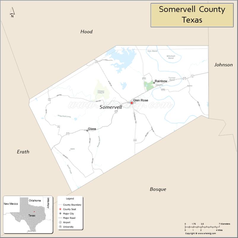
About Somervell County Map, Texas: The map showing the county boundary, county seat, major cities, highways, water bodies and neighbouring counties.
Related Texas Maps
Map of Somervell County, Texas
Somervell County is a county located in the U.S. state of Texas. It's county seat is Glen Rose. As per 2020 census, the population of Somervell County is 9469 people and population density is square miles. According to the United States Census Bureau, the county has a total area of 187 sq mi (484 km2). Somervell County was established on 1875.
Facts about Somervell County, Texas
| Country | United States |
| State | Texas |
| Region | North-Central Texas / Brazos River Valley |
| County Seat | Glen Rose |
| Named After | Alexander Somervell, Texas general and statesman |
| Established | 1875 |
| Organized | 1875 |
| Coordinates | 32.2230° N, 97.7740° W |
| Total Area | 187 sq mi |
| Land Area | 186 sq mi |
| Water Area | 1 sq mi |
| Population (2020) | 9,205 |
| Population Rank | Small rural county in North-Central Texas |
| Major City | Glen Rose |
| Main Industries | Tourism, Healthcare, Energy, Retail |
| Major Airport | None (nearest regional airports outside county) |
| Time Zone | Central Time (UTC−06:00) |
| Known For | Dinosaur Valley State Park, Fossil Rim Wildlife Center, Glen Rose tourism |
| Website | https://www.somervellcountytx.gov |
Top Attractions in Somervell County, Texas
- Dinosaur Valley State Park – Dinosaur tracks and river trails.
- Fossil Rim Wildlife Center – Drive-through wildlife preserve.
- Glen Rose Downtown Square – Shops and small-town charm.
- Somervell County Courthouse – Historic courthouse in Glen Rose.
- Paluxy River – Scenic river views and swimming.
- Creation Evidence Museum – Faith-based science exhibits.
- Barnard’s Mill – Restored historic gristmill.
- Big Rocks Park – Riverfront park and wading area.
- Heritage Park – Local history displays.
- Scenic Hill Country Drives – Rolling landscapes and views.
Cities and Towns in Somervell County, Texas
| Place | Type | Population (Census 2020) | Latitude & Longitude |
|---|---|---|---|
| Glen Rose (county seat) | City | 2659 | 32.2349°N, 97.7553°W |
| Nemo | Unincorporated Community | N/A | 32.2678°N, 97.6639°W |
| Rainbow | Unincorporated Community | N/A | 32.2701°N, 97.6967°W |
| Glass | Unincorporated Community | N/A | 32.3160°N, 97.7730°W |
What are Major Roads and Highways in Somervell County
Major highways connect the county to nearby regions and cities.
- U.S. Highway 67 - primary east-west route connecting Glen Rose with Cleburne, Dallas-Fort Worth, and Stephenville
- State Highway 144 - north-south route connecting Glen Rose with Granbury and Meridian
- Farm to Market Road 56 - connects Glen Rose with Bosque County communities
- Farm to Market Road 200 - serves western portions of the county and ranching areas
- Farm to Market Road 205 - provides access to northeastern parts of the county
What are Neighboring Counties of Somervell County
- Hood County (north)
- Johnson County (east)
- Bosque County (south)
- Erath County (west)
Distance from Somervell County to Nearby Cities
The following distances are measured by road (driving).
- Glen Rose to Granbury (Hood County), Texas - 17 mi (27 km)
- Glen Rose to Cleburne (Johnson County), Texas - 19 mi (31 km)
- Glen Rose to Stephenville (Erath County), Texas - 31 mi (50 km)
- Glen Rose to Meridian (Bosque County), Texas - 28 mi (45 km)
- Glen Rose to Weatherford (Parker County), Texas - 39 mi (63 km)
- Glen Rose to Hillsboro (Hill County), Texas - 42 mi (68 km)
- Glen Rose to Burleson (Johnson County), Texas - 34 mi (55 km)
- Glen Rose to Fort Worth (Tarrant County), Texas - 52 mi (84 km)
- Glen Rose to Waco (McLennan County), Texas - 68 mi (109 km)
- Glen Rose to Mineral Wells (Palo Pinto County), Texas - 55 mi (89 km)
- Glen Rose to Arlington (Tarrant County), Texas - 56 mi (90 km)
- Glen Rose to Dallas (Dallas County), Texas - 72 mi (116 km)
- Glen Rose to Temple (Bell County), Texas - 103 mi (166 km)
- Glen Rose to Abilene (Taylor County), Texas - 139 mi (224 km)
- Glen Rose to Austin (Travis County), Texas - 159 mi (256 km)
Waterbodies in Somervell County
Brazos River, Paluxy River, Squaw Creek Reservoir, Squaw Creek, Rough Creek, Wheeler Branch Reservoir, Barnard Creek, Mustang Creek, Little Barton Creek, Walnut Creek, Mesquite Creek, Spring Branch, Brazos River Watershed, Paluxy River Watershed
Best Golf Courses in Somervell County, Texas
| Golf Course | Location | Latitude & Longitude |
|---|---|---|
| Squaw Valley Golf Course | Glen Rose | 32.2520°N, 97.7560°W |
Colleges and Universities in Somervell County, Texas
Somervell County does not have a college or university campus within its boundaries. Residents are served by nearby institutions in North Central Texas. The county is within the service area of Hill College and has access to several universities in the Dallas-Fort Worth region. :contentReference[oaicite:0]{index=0}
| Institution Name | Type (Public/Private) | Level | Notable For |
|---|---|---|---|
| Hill College | Public | Community College | Primary community college serving the area |
| Tarleton State University | Public | University | Regional public university in Stephenville |
| Texas Christian University | Private | University | Major private university in Fort Worth |
| University of Texas at Arlington | Public | University | Large public research university |
| Texas Wesleyan University | Private | University | Private university in Fort Worth |
References
- U.S. Census Bureau QuickFacts - Somervell County
- Texas State Historical Association - Somervell County
- Official Somervell County Website
- Tour Texas - Somervell County and Squaw Valley Golf Course
- USGS Geographic Names Information System (GNIS)
- Anderson County Map
- Andrews County Map
- Angelina County Map
- Aransas County Map
- Archer County Map
- Armstrong County Map
- Atascosa County Map
- Austin County Map
- Bailey County Map
- Bandera County Map
- Bastrop County Map
- Baylor County Map
- Bee County Map
- Bell County Map
- Bexar County Map
- Blanco County Map
- Borden County Map
- Bosque County Map
- Bowie County Map
- Brazoria County Map
- Brazos County Map
- Brewster County Map
- Briscoe County Map
- Brooks County Map
- Brown County Map
- Burleson County Map
- Burnet County Map
- Caldwell County Map
- Calhoun County Map
- Callahan County Map
- Cameron County Map
- Camp County Map
- Carson County Map
- Cass County Map
- Castro County Map
- Chambers County Map
- Cherokee County Map
- Childress County Map
- Clay County Map
- Cochran County Map
- Coke County Map
- Coleman County Map
- Collin County Map
- Collingsworth County Map
- Colorado County Map
- Comal County Map
- Comanche County Map
- Concho County Map
- Cooke County Map
- Coryell County Map
- Cottle County Map
- Crane County Map
- Crockett County Map
- Crosby County Map
- Culberson County Map
- Dallam County Map
- Dallas County Map
- Dawson County Map
- Deaf Smith County Map
- Delta County Map
- Denton County Map
- DeWitt County Map
- Dickens County Map
- Dimmit County Map
- Donley County Map
- Duval County Map
- Eastland County Map
- Ector County Map
- Edwards County Map
- Ellis County Map
- El Paso County Map
- Erath County Map
- Falls County Map
- Fannin County Map
- Fayette County Map
- Fisher County Map
- Floyd County Map
- Foard County Map
- Fort Bend County Map
- Franklin County Map
- Freestone County Map
- Frio County Map
- Gaines County Map
- Galveston County Map
- Garza County Map
- Gillespie County Map
- Glasscock County Map
- Goliad County Map
- Gonzales County Map
- Gray County Map
- Grayson County Map
- Gregg County Map
- Grimes County Map
- Guadalupe County Map
- Hale County Map
- Hall County Map
- Hamilton County Map
- Hansford County Map
- Hardeman County Map
- Hardin County Map
- Harris County Map
- Harrison County Map
- Hartley County Map
- Haskell County Map
- Hays County Map
- Hemphill County Map
- Henderson County Map
- Hidalgo County Map
- Hill County Map
- Hockley County Map
- Hood County Map
- Hopkins County Map
- Houston County Map
- Howard County Map
- Hudspeth County Map
- Hunt County Map
- Hutchinson County Map
- Irion County Map
- Jack County Map
- Jackson County Map
- Jasper County Map
- Jeff Davis County Map
- Jefferson County Map
- Jim Hogg County Map
- Jim Wells County Map
- Johnson County Map
- Jones County Map
- Karnes County Map
- Kaufman County Map
- Kendall County Map
- Kenedy County Map
- Kent County Map
- Kerr County Map
- Kimble County Map
- King County Map
- Kinney County Map
- Kleberg County Map
- Knox County Map
- Lamar County Map
- Lamb County Map
- Lampasas County Map
- La Salle County Map
- Lavaca County Map
- Lee County Map
- Leon County Map
- Liberty County Map
- Limestone County Map
- Lipscomb County Map
- Live Oak County Map
- Llano County Map
- Loving County Map
- Lubbock County Map
- Lynn County Map
- McCulloch County Map
- McLennan County Map
- McMullen County Map
- Madison County Map
- Marion County Map
- Martin County Map
- Mason County Map
- Matagorda County Map
- Maverick County Map
- Medina County Map
- Menard County Map
- Midland County Map
- Milam County Map
- Mills County Map
- Mitchell County Map
- Montague County Map
- Montgomery County Map
- Moore County Map
- Morris County Map
- Motley County Map
- Nacogdoches County Map
- Navarro County Map
- Newton County Map
- Nolan County Map
- Nueces County Map
- Ochiltree County Map
- Oldham County Map
- Orange County Map
- Palo Pinto County Map
- Panola County Map
- Parker County Map
- Parmer County Map
- Pecos County Map
- Polk County Map
- Potter County Map
- Presidio County Map
- Rains County Map
- Randall County Map
- Reagan County Map
- Real County Map
- Red River County Map
- Reeves County Map
- Refugio County Map
- Roberts County Map
- Robertson County Map
- Rockwall County Map
- Runnels County Map
- Rusk County Map
- Sabine County Map
- San Augustine County Map
- San Jacinto County Map
- San Patricio County Map
- San Saba County Map
- Schleicher County Map
- Scurry County Map
- Shackelford County Map
- Shelby County Map
- Sherman County Map
- Smith County Map
- Somervell County Map
- Starr County Map
- Stephens County Map
- Sterling County Map
- Stonewall County Map
- Sutton County Map
- Swisher County Map
- Tarrant County Map
- Taylor County Map
- Terrell County Map
- Terry County Map
- Throckmorton County Map
- Titus County Map
- Tom Green County Map
- Travis County Map
- Trinity County Map
- Tyler County Map
- Upshur County Map
- Upton County Map
- Uvalde County Map
- Val Verde County Map
- Van Zandt County Map
- Victoria County Map
- Walker County Map
- Waller County Map
- Ward County Map
- Washington County Map
- Webb County Map
- Wharton County Map
- Wheeler County Map
- Wichita County Map
- Wilbarger County Map
- Willacy County Map
- Williamson County Map
- Wilson County Map
- Winkler County Map
- Wise County Map
- Wood County Map
- Yoakum County Map
- Young County Map
- Zapata County Map
- Zavala County Map
- Alabama Counties
- Alaska boroughs
- Arizona Counties
- Arkansas Counties
- California County Map
- Colorado Counties
- Connecticut Counties
- Delaware Counties
- Florida County Map
- Georgia County Map
- Hawaii Counties
- Idaho Counties
- Illinois Counties
- Indiana Counties
- Iowa Counties
- Kansas Counties
- Kentucky Counties
- Louisiana Counties
- Maine Counties
- Maryland Counties
- Massachusetts Counties
- Michigan County Map
- Minnesota Counties
- Mississippi Counties
- Missouri Counties
- Montana Counties
- Nebraska Counties
- Nevada Counties
- New York Counties
- New Hampshire Counties
- New Jersey Counties
- New Mexico Counties
- North Carolina Counties
- North Dakota Counties
- Ohio County Map
- Oklahoma Counties
- Oregon Counties
- Pennsylvania Counties
- Rhode Island Counties
- South Carolina Counties
- South Dakota Counties
- Map of Tennessee
- Texas County Map
- Utah Counties
- Vermont Counties
- Virginia Counties
- Washington Counties
- West Virginia Counties
- Wisconsin Counties
- Wyoming Counties
References
- ^ QuickFacts: Somervell County, Texas - United States Census Bureau
- ^ United States Census Bureau - Population and Housing Data
- ^ TIGER/Line Shapefiles - United States Census Bureau
- ^ United States Geological Survey (USGS)
- ^ National Geodetic Survey (NGS), NOAA
- ^ Official Website of Somervell County, Texas
- ^ Texas Department of Transportation (TxDOT)