Map of Chambers County - Chambers County is a county located in the U.S. state of Texas. Chambers County Map showing cities, highways, important places and water bodies. Get Where is Chambers County located in the map, major cities in Chambers county, population, areas, and places of interest.
Map of Chambers County, Texas
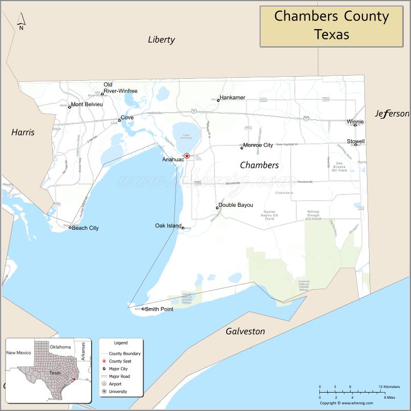
About Chambers County Map, Texas: The map showing the county boundary, county seat, major cities, highways, water bodies and neighbouring counties.
Related Texas Maps
Map of Chambers County, Texas
Chambers County is a county located in the U.S. state of Texas. It's county seat is Anahuac. As per 2020 census, the population of Chambers County is 48865 people and population density is square miles. According to the United States Census Bureau, the county has a total area of 599 sq mi (1,551 km2). Chambers County was established on 1858.
Facts about Chambers County, Texas
| Country | United States |
| State | Texas |
| Region | Texas Gulf Coast / Upper Coast |
| County Seat | Anahuac |
| Named After | Thomas Jefferson Chambers |
| Established | 1858 |
| Organized | 1858 |
| Coordinates | 29.7507° N, 94.6586° W |
| Total Area | 871 sq mi |
| Land Area | 597 sq mi |
| Water Area | 274 sq mi |
| Population (2020) | 46,571 |
| Population Rank | Mid-sized Gulf Coast county |
| Major Cities | Mont Belvieu, Anahuac, Winnie |
| Main Industries | Petrochemicals, Energy Storage, Agriculture, Port & Coastal Services |
| Major Airport | Nearest major airport: William P. Hobby Airport (Houston) |
| Time Zone | Central Time (UTC−06:00) |
| Known For | Anahuac National Wildlife Refuge, Trinity Bay, Energy hub in Mont Belvieu |
| Website | https://www.chamberscountytx.gov |
Top Attractions in Chambers County, Texas
- Anahuac National Wildlife Refuge – Marshland habitat ideal for bird-watching and wildlife viewing.
- Fort Anahuac Park – Waterfront park with historic fort ruins and Trinity Bay views.
- Trinity River Island Recreation Area – Fishing, boating, and riverside relaxation.
- Cedar Hill Park (Wallisville) – Picnic areas, trails, and scenic bayou access.
- Chambers County Museum at Wallisville – Exhibits on early settlers and regional history.
- White’s Park – Community fairgrounds hosting rodeos and events.
- Double Bayou Park – Peaceful spot for kayaking, fishing, and birding.
- McCollum Park – Small community park with open green space.
- Barrow Ranch Area – Rural drives showcasing coastal prairie landscapes.
- Smith Point Hawk Watch – Renowned site for observing migrating raptors.
Cities and Towns in Chambers County, Texas
| Place | Type | Population (Census 2020) | Latitude & Longitude |
|---|---|---|---|
| Anahuac (county seat) | City | 2108 | 29.7730°N, 94.6827°W |
| Baytown (partly in Harris County) | City | 83701 | 29.7355°N, 94.9774°W |
| Mont Belvieu | City | 7837 | 29.8461°N, 94.8908°W |
| Beach City | City | 2198 | 29.6624°N, 94.8891°W |
| Cove | City | 2861 | 29.7863°N, 94.7694°W |
| Old River-Winfree | City | 1279 | 29.8677°N, 94.8268°W |
| Stowell | Census Designated Place (CDP) | 1628 | 29.7875°N, 94.3827°W |
| Winnie | Census Designated Place (CDP) | 3254 | 29.8208°N, 94.3841°W |
| Highlands (partly in Chambers County) | Census Designated Place (CDP) | 7828 | 29.8180°N, 95.0563°W |
| Hankamer | Unincorporated Community | N/A | 29.8552°N, 94.6213°W |
| Monroe City | Unincorporated Community | N/A | 29.9366°N, 94.6871°W |
| Smith Point | Unincorporated Community | N/A | 29.5421°N, 94.7782°W |
| Wallisville | Unincorporated Community | N/A | 29.8202°N, 94.7288°W |
What are Major Roads and Highways in Chambers County
Major highways connect the county to nearby regions and cities.
- Interstate 10 - east toward Beaumont and west toward Houston
- State Highway 61 - connects Anahuac with Hankamer and Interstate 10
- State Highway 65 - links Anahuac with coastal communities near Smith Point
- State Highway 99 (Grand Parkway) - western connection toward Houston metropolitan areas
- Farm to Market Road 563 - north-south route through central Chambers County
- Farm to Market Road 1406 - serves western agricultural communities
- Farm to Market Road 1985 - connects Winnie and nearby rural areas
What are Neighboring Counties of Chambers County
- Liberty County (north)
- Jefferson County (east)
- Galveston County (south)
- Harris County (west)
Distance from Chambers County to Nearby Cities
The following distances are measured by road (driving).
- Anahuac to Mont Belvieu (Chambers County), Texas - 17 mi (27 km)
- Anahuac to Cove (Chambers County), Texas - 8 mi (13 km)
- Anahuac to Winnie (Chambers County), Texas - 19 mi (31 km)
- Anahuac to Beach City (Chambers County), Texas - 21 mi (34 km)
- Anahuac to Baytown (Harris County), Texas - 24 mi (39 km)
- Anahuac to Dayton (Liberty County), Texas - 27 mi (43 km)
- Anahuac to Liberty (Liberty County), Texas - 34 mi (55 km)
- Anahuac to Beaumont (Jefferson County), Texas - 43 mi (69 km)
- Anahuac to Texas City (Galveston County), Texas - 48 mi (77 km)
- Anahuac to Galveston (Galveston County), Texas - 63 mi (101 km)
- Anahuac to Houston (Harris County), Texas - 50 mi (80 km)
- Anahuac to Pasadena (Harris County), Texas - 42 mi (68 km)
- Anahuac to Port Arthur (Jefferson County), Texas - 57 mi (92 km)
- Anahuac to Lake Jackson (Brazoria County), Texas - 87 mi (140 km)
- Anahuac to Huntsville (Walker County), Texas - 97 mi (156 km)
Waterbodies in Chambers County
Trinity Bay, Galveston Bay, East Bay, Cedar Bayou, Old River, Trinity River, Lake Anahuac, Turtle Bay, Double Bayou, Lost Lake, Wallisville Lake, Anahuac National Wildlife Refuge wetlands, Gulf Coast marshes, coastal estuaries, tidal creeks, reservoirs, and bayous
Best Golf Courses in Chambers County, Texas
| Golf Course | Location | Latitude & Longitude |
|---|---|---|
| Eagle Pointe Golf Club | Mont Belvieu | 29.8465°N, 94.8885°W |
| River Terrace Golf Course | Mont Belvieu | 29.8512°N, 94.9058°W |
| Chambers County Golf Course | Anahuac | 29.7711°N, 94.6887°W |
Colleges and Universities in Chambers County, Texas
| Institution Name | Type | Level | Notable For |
|---|---|---|---|
| Lee College | Public | Community College | Primary community college serving Chambers County |
| Lamar Institute of Technology | Public | Community College | Technical and workforce training programs |
| Texas A&M AgriLife Extension Service - Chambers County | Public | University | Agricultural and community education programs |
References
- U.S. Census Bureau - Chambers County Profile
- Official Chambers County Website
- Texas State Historical Association - Chambers County
- Lee College
- Anahuac National Wildlife Refuge
- Anderson County Map
- Andrews County Map
- Angelina County Map
- Aransas County Map
- Archer County Map
- Armstrong County Map
- Atascosa County Map
- Austin County Map
- Bailey County Map
- Bandera County Map
- Bastrop County Map
- Baylor County Map
- Bee County Map
- Bell County Map
- Bexar County Map
- Blanco County Map
- Borden County Map
- Bosque County Map
- Bowie County Map
- Brazoria County Map
- Brazos County Map
- Brewster County Map
- Briscoe County Map
- Brooks County Map
- Brown County Map
- Burleson County Map
- Burnet County Map
- Caldwell County Map
- Calhoun County Map
- Callahan County Map
- Cameron County Map
- Camp County Map
- Carson County Map
- Cass County Map
- Castro County Map
- Chambers County Map
- Cherokee County Map
- Childress County Map
- Clay County Map
- Cochran County Map
- Coke County Map
- Coleman County Map
- Collin County Map
- Collingsworth County Map
- Colorado County Map
- Comal County Map
- Comanche County Map
- Concho County Map
- Cooke County Map
- Coryell County Map
- Cottle County Map
- Crane County Map
- Crockett County Map
- Crosby County Map
- Culberson County Map
- Dallam County Map
- Dallas County Map
- Dawson County Map
- Deaf Smith County Map
- Delta County Map
- Denton County Map
- DeWitt County Map
- Dickens County Map
- Dimmit County Map
- Donley County Map
- Duval County Map
- Eastland County Map
- Ector County Map
- Edwards County Map
- Ellis County Map
- El Paso County Map
- Erath County Map
- Falls County Map
- Fannin County Map
- Fayette County Map
- Fisher County Map
- Floyd County Map
- Foard County Map
- Fort Bend County Map
- Franklin County Map
- Freestone County Map
- Frio County Map
- Gaines County Map
- Galveston County Map
- Garza County Map
- Gillespie County Map
- Glasscock County Map
- Goliad County Map
- Gonzales County Map
- Gray County Map
- Grayson County Map
- Gregg County Map
- Grimes County Map
- Guadalupe County Map
- Hale County Map
- Hall County Map
- Hamilton County Map
- Hansford County Map
- Hardeman County Map
- Hardin County Map
- Harris County Map
- Harrison County Map
- Hartley County Map
- Haskell County Map
- Hays County Map
- Hemphill County Map
- Henderson County Map
- Hidalgo County Map
- Hill County Map
- Hockley County Map
- Hood County Map
- Hopkins County Map
- Houston County Map
- Howard County Map
- Hudspeth County Map
- Hunt County Map
- Hutchinson County Map
- Irion County Map
- Jack County Map
- Jackson County Map
- Jasper County Map
- Jeff Davis County Map
- Jefferson County Map
- Jim Hogg County Map
- Jim Wells County Map
- Johnson County Map
- Jones County Map
- Karnes County Map
- Kaufman County Map
- Kendall County Map
- Kenedy County Map
- Kent County Map
- Kerr County Map
- Kimble County Map
- King County Map
- Kinney County Map
- Kleberg County Map
- Knox County Map
- Lamar County Map
- Lamb County Map
- Lampasas County Map
- La Salle County Map
- Lavaca County Map
- Lee County Map
- Leon County Map
- Liberty County Map
- Limestone County Map
- Lipscomb County Map
- Live Oak County Map
- Llano County Map
- Loving County Map
- Lubbock County Map
- Lynn County Map
- McCulloch County Map
- McLennan County Map
- McMullen County Map
- Madison County Map
- Marion County Map
- Martin County Map
- Mason County Map
- Matagorda County Map
- Maverick County Map
- Medina County Map
- Menard County Map
- Midland County Map
- Milam County Map
- Mills County Map
- Mitchell County Map
- Montague County Map
- Montgomery County Map
- Moore County Map
- Morris County Map
- Motley County Map
- Nacogdoches County Map
- Navarro County Map
- Newton County Map
- Nolan County Map
- Nueces County Map
- Ochiltree County Map
- Oldham County Map
- Orange County Map
- Palo Pinto County Map
- Panola County Map
- Parker County Map
- Parmer County Map
- Pecos County Map
- Polk County Map
- Potter County Map
- Presidio County Map
- Rains County Map
- Randall County Map
- Reagan County Map
- Real County Map
- Red River County Map
- Reeves County Map
- Refugio County Map
- Roberts County Map
- Robertson County Map
- Rockwall County Map
- Runnels County Map
- Rusk County Map
- Sabine County Map
- San Augustine County Map
- San Jacinto County Map
- San Patricio County Map
- San Saba County Map
- Schleicher County Map
- Scurry County Map
- Shackelford County Map
- Shelby County Map
- Sherman County Map
- Smith County Map
- Somervell County Map
- Starr County Map
- Stephens County Map
- Sterling County Map
- Stonewall County Map
- Sutton County Map
- Swisher County Map
- Tarrant County Map
- Taylor County Map
- Terrell County Map
- Terry County Map
- Throckmorton County Map
- Titus County Map
- Tom Green County Map
- Travis County Map
- Trinity County Map
- Tyler County Map
- Upshur County Map
- Upton County Map
- Uvalde County Map
- Val Verde County Map
- Van Zandt County Map
- Victoria County Map
- Walker County Map
- Waller County Map
- Ward County Map
- Washington County Map
- Webb County Map
- Wharton County Map
- Wheeler County Map
- Wichita County Map
- Wilbarger County Map
- Willacy County Map
- Williamson County Map
- Wilson County Map
- Winkler County Map
- Wise County Map
- Wood County Map
- Yoakum County Map
- Young County Map
- Zapata County Map
- Zavala County Map
- Alabama Counties
- Alaska boroughs
- Arizona Counties
- Arkansas Counties
- California County Map
- Colorado Counties
- Connecticut Counties
- Delaware Counties
- Florida County Map
- Georgia County Map
- Hawaii Counties
- Idaho Counties
- Illinois Counties
- Indiana Counties
- Iowa Counties
- Kansas Counties
- Kentucky Counties
- Louisiana Counties
- Maine Counties
- Maryland Counties
- Massachusetts Counties
- Michigan County Map
- Minnesota Counties
- Mississippi Counties
- Missouri Counties
- Montana Counties
- Nebraska Counties
- Nevada Counties
- New York Counties
- New Hampshire Counties
- New Jersey Counties
- New Mexico Counties
- North Carolina Counties
- North Dakota Counties
- Ohio County Map
- Oklahoma Counties
- Oregon Counties
- Pennsylvania Counties
- Rhode Island Counties
- South Carolina Counties
- South Dakota Counties
- Map of Tennessee
- Texas County Map
- Utah Counties
- Vermont Counties
- Virginia Counties
- Washington Counties
- West Virginia Counties
- Wisconsin Counties
- Wyoming Counties
References
- ^ QuickFacts: Chambers County, Texas - United States Census Bureau
- ^ United States Census Bureau - Population and Housing Data
- ^ TIGER/Line Shapefiles - United States Census Bureau
- ^ United States Geological Survey (USGS)
- ^ National Geodetic Survey (NGS), NOAA
- ^ Official Website of Chambers County, Texas
- ^ Texas Department of Transportation (TxDOT)