Map of Carson County - Carson County is a county located in the U.S. state of Texas. Carson County Map showing cities, highways, important places and water bodies. Get Where is Carson County located in the map, major cities in Carson county, population, areas, and places of interest.
Map of Carson County, Texas
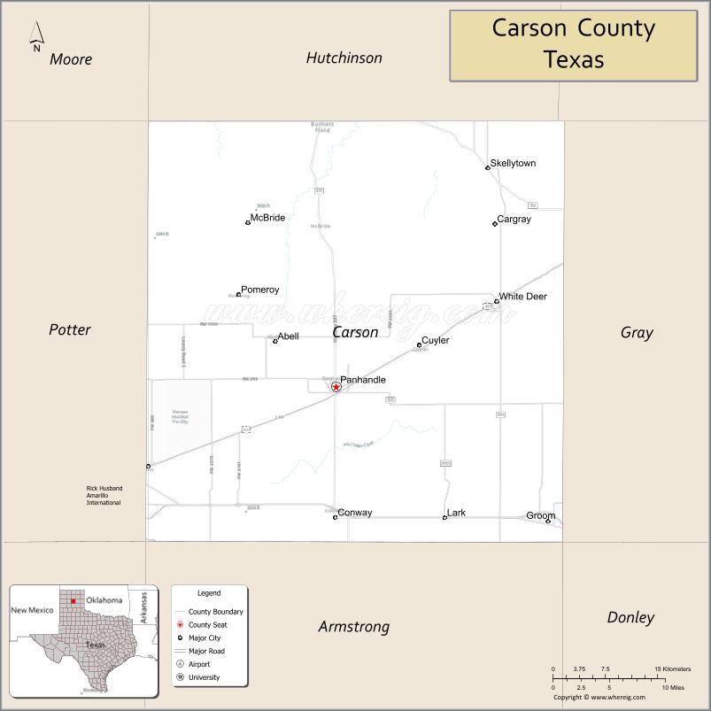
About Carson County Map, Texas: The map showing the county boundary, county seat, major cities, highways, water bodies and neighbouring counties.
Related Texas Maps
Map of Carson County, Texas
Carson County is a county located in the U.S. state of Texas. It's county seat is Panhandle. As per 2020 census, the population of Carson County is 5746 people and population density is square miles. According to the United States Census Bureau, the county has a total area of 923 sq mi (2,391 km2). Carson County was established on 1876.
Facts about Carson County, Texas
| Country | United States |
| State | Texas |
| Region | Texas Panhandle |
| County Seat | Panhandle |
| Named After | Samuel P. Carson |
| Established | 1876 |
| Organized | 1888 |
| Coordinates | 35.4036° N, 101.3559° W |
| Total Area | 924 sq mi |
| Land Area | 922 sq mi |
| Water Area | 2 sq mi |
| Population (2020) | 5,807 |
| Population Rank | Sparsely populated Panhandle county |
| Major Cities | Panhandle, White Deer, Skellytown, Groom |
| Main Industries | Energy (Oil & Gas), Agriculture, Wind Power |
| Major Airport | Nearest major airport: Rick Husband Amarillo International Airport |
| Time Zone | Central Time (UTC−06:00) |
| Known For | Leaning Tower of Groom, Historic Route 66, Ranching and energy production |
| Website | https://www.co.carson.tx.us |
Top Attractions in Carson County, Texas
- Palo Duro Canyon State Park (Nearby Access) – Dramatic canyon views and scenic trails near the county line.
- Carson County Square House Museum (Panhandle) – Historic buildings and exhibits on pioneer life.
- Panhandle Downtown Historic District – Small-town shops, murals, and local charm.
- White Deer Land Museum (Pampa Region) – Ranching and settlement artifacts tied to regional history.
- McLean Alanreed Area Route 66 Sites – Classic roadside stops along historic Route 66.
- Grissom Park (Panhandle) – Community park with walking areas and playgrounds.
- Historic Lutheran Church (White Deer) – Striking church architecture tied to early settlers.
- White Deer City Park – Open green space and family recreation facilities.
- Clarendon College – PDI Campus – Historic architecture and local cultural programs.
- Scenic Plains Drives – Wide-open High Plains landscapes ideal for photography.
Cities and Towns in Carson County, Texas
| Place | Type | Population (Census 2020) | Latitude & Longitude |
|---|---|---|---|
| Panhandle (county seat) | Town | 2432 | 35.3456°N, 101.3804°W |
| Groom | Town | 574 | 35.2031°N, 101.1063°W |
| Skellytown | Town | 473 | 35.5703°N, 101.1704°W |
| White Deer | Town | 1000 | 35.4342°N, 101.1721°W |
| Conway | Unincorporated Community | N/A | 35.2077°N, 101.4043°W |
| Lark | Unincorporated Community | N/A | 35.5787°N, 101.3568°W |
| Cuyler | Unincorporated Community | N/A | 35.4689°N, 101.5824°W |
What are Major Roads and Highways in Carson County
Major highways connect the county to nearby regions and cities.
- Interstate 40 - east toward Oklahoma City and west toward Amarillo and New Mexico
- U.S. Highway 60 - northeast toward Pampa and southwest toward Amarillo
- Texas State Highway 207 - south toward Claude and north toward Hutchinson County
- Farm to Market Road 293 - serves Panhandle and surrounding agricultural areas
- Farm to Market Road 294 - connects Groom with rural communities
- Farm to Market Road 2373 - links White Deer and Skellytown
What are Neighboring Counties of Carson County
- Hutchinson County (north)
- Roberts County (northeast)
- Gray County (east)
- Donley County (southeast)
- Armstrong County (south)
- Randall County (southwest)
- Potter County (west)
- Moore County (northwest)
Distance from Carson County to Nearby Cities
The following distances are measured by road (driving).
- Panhandle to White Deer (Carson County), Texas - 12 mi (19 km)
- Panhandle to Groom (Carson County), Texas - 18 mi (29 km)
- Panhandle to Skellytown (Carson County), Texas - 17 mi (27 km)
- Panhandle to Amarillo (Potter County), Texas - 26 mi (42 km)
- Panhandle to Pampa (Gray County), Texas - 30 mi (48 km)
- Panhandle to Claude (Armstrong County), Texas - 29 mi (47 km)
- Panhandle to Borger (Hutchinson County), Texas - 34 mi (55 km)
- Panhandle to Canadian (Hemphill County), Texas - 64 mi (103 km)
- Panhandle to Clarendon (Donley County), Texas - 63 mi (101 km)
- Panhandle to Dumas (Moore County), Texas - 52 mi (84 km)
- Panhandle to Hereford (Deaf Smith County), Texas - 66 mi (106 km)
- Panhandle to Perryton (Ochiltree County), Texas - 102 mi (164 km)
- Panhandle to Lubbock (Lubbock County), Texas - 126 mi (203 km)
- Panhandle to Wichita Falls (Wichita County), Texas - 224 mi (360 km)
- Panhandle to Oklahoma City, Oklahoma - 255 mi (410 km)
Waterbodies in Carson County
Palo Duro Creek, White Deer Creek, Tierra Blanca Creek, Canadian River watershed, McClellan Creek tributaries, Dixon Creek tributaries, Prairie Dog Creek tributaries, stock ponds, playa lakes, ranch reservoirs, seasonal wetlands, springs, and intermittent streams
Best Golf Courses in Carson County, Texas
| Golf Course | Location | Latitude & Longitude |
|---|---|---|
| Panhandle Country Club Golf Course | Panhandle | 35.3481°N, 101.3928°W |
| White Deer Land Museum Golf Course | White Deer | 35.4327°N, 101.1763°W |
Colleges and Universities in Carson County, Texas
| Institution Name | Type | Level | Notable For |
|---|---|---|---|
| Amarillo College | Public | Community College | Community college district serving Carson County |
| West Texas A&M University Extension Programs | Public | University | Regional outreach and continuing education |
References
- U.S. Census Bureau - Carson County QuickFacts
- Official Carson County Website
- Texas State Historical Association - Carson County
- Amarillo College
- West Texas A&M University
- Anderson County Map
- Andrews County Map
- Angelina County Map
- Aransas County Map
- Archer County Map
- Armstrong County Map
- Atascosa County Map
- Austin County Map
- Bailey County Map
- Bandera County Map
- Bastrop County Map
- Baylor County Map
- Bee County Map
- Bell County Map
- Bexar County Map
- Blanco County Map
- Borden County Map
- Bosque County Map
- Bowie County Map
- Brazoria County Map
- Brazos County Map
- Brewster County Map
- Briscoe County Map
- Brooks County Map
- Brown County Map
- Burleson County Map
- Burnet County Map
- Caldwell County Map
- Calhoun County Map
- Callahan County Map
- Cameron County Map
- Camp County Map
- Carson County Map
- Cass County Map
- Castro County Map
- Chambers County Map
- Cherokee County Map
- Childress County Map
- Clay County Map
- Cochran County Map
- Coke County Map
- Coleman County Map
- Collin County Map
- Collingsworth County Map
- Colorado County Map
- Comal County Map
- Comanche County Map
- Concho County Map
- Cooke County Map
- Coryell County Map
- Cottle County Map
- Crane County Map
- Crockett County Map
- Crosby County Map
- Culberson County Map
- Dallam County Map
- Dallas County Map
- Dawson County Map
- Deaf Smith County Map
- Delta County Map
- Denton County Map
- DeWitt County Map
- Dickens County Map
- Dimmit County Map
- Donley County Map
- Duval County Map
- Eastland County Map
- Ector County Map
- Edwards County Map
- Ellis County Map
- El Paso County Map
- Erath County Map
- Falls County Map
- Fannin County Map
- Fayette County Map
- Fisher County Map
- Floyd County Map
- Foard County Map
- Fort Bend County Map
- Franklin County Map
- Freestone County Map
- Frio County Map
- Gaines County Map
- Galveston County Map
- Garza County Map
- Gillespie County Map
- Glasscock County Map
- Goliad County Map
- Gonzales County Map
- Gray County Map
- Grayson County Map
- Gregg County Map
- Grimes County Map
- Guadalupe County Map
- Hale County Map
- Hall County Map
- Hamilton County Map
- Hansford County Map
- Hardeman County Map
- Hardin County Map
- Harris County Map
- Harrison County Map
- Hartley County Map
- Haskell County Map
- Hays County Map
- Hemphill County Map
- Henderson County Map
- Hidalgo County Map
- Hill County Map
- Hockley County Map
- Hood County Map
- Hopkins County Map
- Houston County Map
- Howard County Map
- Hudspeth County Map
- Hunt County Map
- Hutchinson County Map
- Irion County Map
- Jack County Map
- Jackson County Map
- Jasper County Map
- Jeff Davis County Map
- Jefferson County Map
- Jim Hogg County Map
- Jim Wells County Map
- Johnson County Map
- Jones County Map
- Karnes County Map
- Kaufman County Map
- Kendall County Map
- Kenedy County Map
- Kent County Map
- Kerr County Map
- Kimble County Map
- King County Map
- Kinney County Map
- Kleberg County Map
- Knox County Map
- Lamar County Map
- Lamb County Map
- Lampasas County Map
- La Salle County Map
- Lavaca County Map
- Lee County Map
- Leon County Map
- Liberty County Map
- Limestone County Map
- Lipscomb County Map
- Live Oak County Map
- Llano County Map
- Loving County Map
- Lubbock County Map
- Lynn County Map
- McCulloch County Map
- McLennan County Map
- McMullen County Map
- Madison County Map
- Marion County Map
- Martin County Map
- Mason County Map
- Matagorda County Map
- Maverick County Map
- Medina County Map
- Menard County Map
- Midland County Map
- Milam County Map
- Mills County Map
- Mitchell County Map
- Montague County Map
- Montgomery County Map
- Moore County Map
- Morris County Map
- Motley County Map
- Nacogdoches County Map
- Navarro County Map
- Newton County Map
- Nolan County Map
- Nueces County Map
- Ochiltree County Map
- Oldham County Map
- Orange County Map
- Palo Pinto County Map
- Panola County Map
- Parker County Map
- Parmer County Map
- Pecos County Map
- Polk County Map
- Potter County Map
- Presidio County Map
- Rains County Map
- Randall County Map
- Reagan County Map
- Real County Map
- Red River County Map
- Reeves County Map
- Refugio County Map
- Roberts County Map
- Robertson County Map
- Rockwall County Map
- Runnels County Map
- Rusk County Map
- Sabine County Map
- San Augustine County Map
- San Jacinto County Map
- San Patricio County Map
- San Saba County Map
- Schleicher County Map
- Scurry County Map
- Shackelford County Map
- Shelby County Map
- Sherman County Map
- Smith County Map
- Somervell County Map
- Starr County Map
- Stephens County Map
- Sterling County Map
- Stonewall County Map
- Sutton County Map
- Swisher County Map
- Tarrant County Map
- Taylor County Map
- Terrell County Map
- Terry County Map
- Throckmorton County Map
- Titus County Map
- Tom Green County Map
- Travis County Map
- Trinity County Map
- Tyler County Map
- Upshur County Map
- Upton County Map
- Uvalde County Map
- Val Verde County Map
- Van Zandt County Map
- Victoria County Map
- Walker County Map
- Waller County Map
- Ward County Map
- Washington County Map
- Webb County Map
- Wharton County Map
- Wheeler County Map
- Wichita County Map
- Wilbarger County Map
- Willacy County Map
- Williamson County Map
- Wilson County Map
- Winkler County Map
- Wise County Map
- Wood County Map
- Yoakum County Map
- Young County Map
- Zapata County Map
- Zavala County Map
- Alabama Counties
- Alaska boroughs
- Arizona Counties
- Arkansas Counties
- California County Map
- Colorado Counties
- Connecticut Counties
- Delaware Counties
- Florida County Map
- Georgia County Map
- Hawaii Counties
- Idaho Counties
- Illinois Counties
- Indiana Counties
- Iowa Counties
- Kansas Counties
- Kentucky Counties
- Louisiana Counties
- Maine Counties
- Maryland Counties
- Massachusetts Counties
- Michigan County Map
- Minnesota Counties
- Mississippi Counties
- Missouri Counties
- Montana Counties
- Nebraska Counties
- Nevada Counties
- New York Counties
- New Hampshire Counties
- New Jersey Counties
- New Mexico Counties
- North Carolina Counties
- North Dakota Counties
- Ohio County Map
- Oklahoma Counties
- Oregon Counties
- Pennsylvania Counties
- Rhode Island Counties
- South Carolina Counties
- South Dakota Counties
- Map of Tennessee
- Texas County Map
- Utah Counties
- Vermont Counties
- Virginia Counties
- Washington Counties
- West Virginia Counties
- Wisconsin Counties
- Wyoming Counties
References
- ^ QuickFacts: Carson County, Texas - United States Census Bureau
- ^ United States Census Bureau - Population and Housing Data
- ^ TIGER/Line Shapefiles - United States Census Bureau
- ^ United States Geological Survey (USGS)
- ^ National Geodetic Survey (NGS), NOAA
- ^ Official Website of Carson County, Texas
- ^ Texas Department of Transportation (TxDOT)