Map of Brazos County - Brazos County is a county located in the U.S. state of Texas. Brazos County Map showing cities, highways, important places and water bodies. Get Where is Brazos County located in the map, major cities in Brazos county, population, areas, and places of interest.
Map of Brazos County, Texas
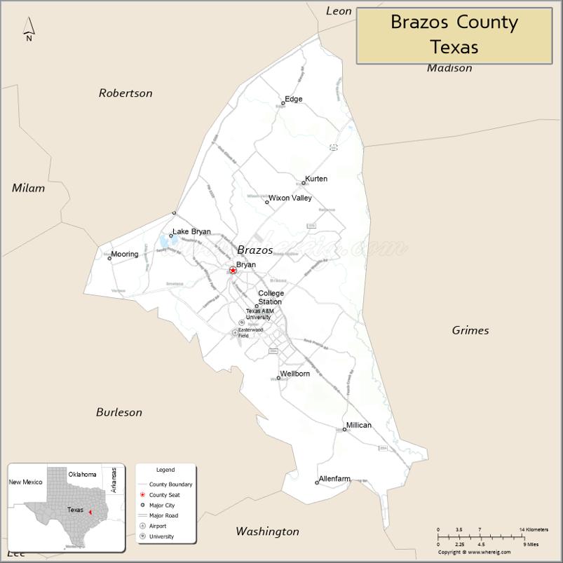
About Brazos County Map, Texas: The map showing the county boundary, county seat, major cities, highways, water bodies and neighbouring counties.
Related Texas Maps
Map of Brazos County, Texas
Brazos County is a county located in the U.S. state of Texas. It's county seat is Bryan. As per 2020 census, the population of Brazos County is 237032 people and population density is square miles. According to the United States Census Bureau, the county has a total area of 586 sq mi (1,518 km2). Brazos County was established on 1841.
Facts about Brazos County, Texas
| Country | United States |
| State | Texas |
| Region | East-Central Texas / Brazos Valley |
| County Seat | Bryan |
| Named After | Brazos River |
| Established | 1841 |
| Organized | 1843 |
| Coordinates | 30.6633° N, 96.3020° W |
| Total Area | 591 sq mi |
| Land Area | 585 sq mi |
| Water Area | 6 sq mi |
| Population (2020) | 233,849 |
| Population Rank | Major county in the Brazos Valley region |
| Major Cities | Bryan, College Station |
| Main Industries | Education (Texas A&M University), Research, Healthcare, Technology, Agriculture |
| Major Airport | Easterwood Airport (serving Bryan–College Station) |
| Time Zone | Central Time (UTC−06:00) |
| Known For | Texas A&M University, Aggie traditions, Research and innovation hub |
| Website | https://www.brazoscountytx.gov |
Top Attractions in Brazos County, Texas
- Texas A&M University – Historic campus with landmarks, museums, and events.
- George H.W. Bush Presidential Library & Museum – Exhibits on the life and presidency of George H.W. Bush.
- Museum of the American GI – Military vehicles and interactive wartime exhibits.
- Brazos Valley Museum of Natural History – Local wildlife, fossils, and science displays.
- Wolf Pen Creek Park – Amphitheater, trails, and green spaces.
- Veterans Park & Athletic Complex – Memorial areas and sports facilities.
- Northgate District – Lively area with dining, bars, and entertainment near campus.
- Research Park (Texas A&M) – Scenic park with ponds and walking paths.
- Lake Bryan – Lakeside recreation, boating, and biking trails.
- Historic Downtown Bryan – Shops, art galleries, restaurants, and heritage buildings.
Cities and Towns in Brazos County, Texas
| Place | Type | Population (Census 2020) | Latitude & Longitude |
|---|---|---|---|
| Bryan (county seat) | City | 83260 | 30.6744°N, 96.3698°W |
| College Station | City | 120511 | 30.6279°N, 96.3344°W |
| Kurten | Town | 399 | 30.7746°N, 96.2861°W |
| Millican | Town | 240 | 30.4230°N, 96.2166°W |
| Wixon Valley | City | 268 | 30.7263°N, 96.2969°W |
| Lake Bryan | Census Designated Place (CDP) | 304 | 30.7193°N, 96.2964°W |
| Benchley | Unincorporated Community | N/A | 30.7416°N, 96.4336°W |
| Harvey | Unincorporated Community | N/A | 30.6902°N, 96.3019°W |
| Steep Hollow | Unincorporated Community | N/A | 30.8147°N, 96.2124°W |
| Tabor | Unincorporated Community | N/A | 30.7721°N, 96.4036°W |
| Wellborn | Unincorporated Community | N/A | 30.5363°N, 96.3067°W |
What are Major Roads and Highways in Brazos County
Major highways connect the county to nearby regions and cities.
- State Highway 6 - north toward Waco and south toward Houston
- State Highway 21 - east toward Madisonville and west toward Austin area
- State Highway 47 - serves eastern Bryan and the Texas A&M RELLIS Campus
- State Highway 30 - connects College Station with Huntsville
- Farm to Market Road 60 - University Drive corridor through Bryan and College Station
- Farm to Market Road 1179 - serves northern Brazos County communities
- Farm to Market Road 2154 - Wellborn Road through College Station
- Farm to Market Road 2818 - major loop route around Bryan and College Station
What are Neighboring Counties of Brazos County
- Robertson County (north)
- Madison County (east)
- Grimes County (south)
- Washington County (southwest)
- Burleson County (west)
- Leon County (northeast)
Distance from Brazos County to Nearby Cities
The following distances are measured by road (driving).
- Bryan to College Station (Brazos County), Texas - 5 mi (8 km)
- Bryan to Navasota (Grimes County), Texas - 25 mi (40 km)
- Bryan to Brenham (Washington County), Texas - 42 mi (68 km)
- Bryan to Caldwell (Burleson County), Texas - 30 mi (48 km)
- Bryan to Hearne (Robertson County), Texas - 18 mi (29 km)
- Bryan to Madisonville (Madison County), Texas - 34 mi (55 km)
- Bryan to Centerville (Leon County), Texas - 44 mi (71 km)
- Bryan to Huntsville (Walker County), Texas - 48 mi (77 km)
- Bryan to Conroe (Montgomery County), Texas - 70 mi (113 km)
- Bryan to Temple (Bell County), Texas - 69 mi (111 km)
- Bryan to Waco (McLennan County), Texas - 88 mi (142 km)
- Bryan to Austin (Travis County), Texas - 105 mi (169 km)
- Bryan to Houston (Harris County), Texas - 100 mi (161 km)
- Bryan to College Station Easterwood Airport Area (Brazos County), Texas - 8 mi (13 km)
- Bryan to Dallas (Dallas County), Texas - 184 mi (296 km)
Waterbodies in Brazos County
Brazos River, Navasota River, Lake Bryan, Burton Creek, Carter Creek, Bee Creek, Lick Creek, Peach Creek, Turkey Creek, Spring Creek, Carters Creek Reservoir, Brazos River watershed, Navasota River watershed, wetlands, stock ponds, floodplain lakes, and seasonal streams
Best Golf Courses in Brazos County, Texas
| Golf Course | Location | Latitude & Longitude |
|---|---|---|
| Traditions Club | Bryan | 30.6839°N, 96.4304°W |
| Briarcrest Country Club | Bryan | 30.6848°N, 96.3385°W |
| Miramont Country Club | Bryan | 30.6465°N, 96.3577°W |
| The Golf Club at Texas A&M | College Station | 30.6105°N, 96.3407°W |
| Pebble Creek Country Club | College Station | 30.5572°N, 96.2671°W |
| Anderson Creek Golf Club | College Station | 30.5189°N, 96.2145°W |
Colleges and Universities in Brazos County, Texas
| Institution Name | Type | Level | Notable For |
|---|---|---|---|
| Texas A&M University | Public | University | Flagship research university and land-grant institution |
| Blinn College - Bryan Campus | Public | Community College | Academic transfer and workforce education |
| Texas A&M University School of Law Outreach Programs | Public | University | Professional and continuing education |
| Texas A&M Health Science Center | Public | University | Health professions education and research |
References
- U.S. Census Bureau - Brazos County QuickFacts
- Official Brazos County Website
- Texas State Historical Association - Brazos County
- Texas A&M University
- Blinn College
- Anderson County Map
- Andrews County Map
- Angelina County Map
- Aransas County Map
- Archer County Map
- Armstrong County Map
- Atascosa County Map
- Austin County Map
- Bailey County Map
- Bandera County Map
- Bastrop County Map
- Baylor County Map
- Bee County Map
- Bell County Map
- Bexar County Map
- Blanco County Map
- Borden County Map
- Bosque County Map
- Bowie County Map
- Brazoria County Map
- Brazos County Map
- Brewster County Map
- Briscoe County Map
- Brooks County Map
- Brown County Map
- Burleson County Map
- Burnet County Map
- Caldwell County Map
- Calhoun County Map
- Callahan County Map
- Cameron County Map
- Camp County Map
- Carson County Map
- Cass County Map
- Castro County Map
- Chambers County Map
- Cherokee County Map
- Childress County Map
- Clay County Map
- Cochran County Map
- Coke County Map
- Coleman County Map
- Collin County Map
- Collingsworth County Map
- Colorado County Map
- Comal County Map
- Comanche County Map
- Concho County Map
- Cooke County Map
- Coryell County Map
- Cottle County Map
- Crane County Map
- Crockett County Map
- Crosby County Map
- Culberson County Map
- Dallam County Map
- Dallas County Map
- Dawson County Map
- Deaf Smith County Map
- Delta County Map
- Denton County Map
- DeWitt County Map
- Dickens County Map
- Dimmit County Map
- Donley County Map
- Duval County Map
- Eastland County Map
- Ector County Map
- Edwards County Map
- Ellis County Map
- El Paso County Map
- Erath County Map
- Falls County Map
- Fannin County Map
- Fayette County Map
- Fisher County Map
- Floyd County Map
- Foard County Map
- Fort Bend County Map
- Franklin County Map
- Freestone County Map
- Frio County Map
- Gaines County Map
- Galveston County Map
- Garza County Map
- Gillespie County Map
- Glasscock County Map
- Goliad County Map
- Gonzales County Map
- Gray County Map
- Grayson County Map
- Gregg County Map
- Grimes County Map
- Guadalupe County Map
- Hale County Map
- Hall County Map
- Hamilton County Map
- Hansford County Map
- Hardeman County Map
- Hardin County Map
- Harris County Map
- Harrison County Map
- Hartley County Map
- Haskell County Map
- Hays County Map
- Hemphill County Map
- Henderson County Map
- Hidalgo County Map
- Hill County Map
- Hockley County Map
- Hood County Map
- Hopkins County Map
- Houston County Map
- Howard County Map
- Hudspeth County Map
- Hunt County Map
- Hutchinson County Map
- Irion County Map
- Jack County Map
- Jackson County Map
- Jasper County Map
- Jeff Davis County Map
- Jefferson County Map
- Jim Hogg County Map
- Jim Wells County Map
- Johnson County Map
- Jones County Map
- Karnes County Map
- Kaufman County Map
- Kendall County Map
- Kenedy County Map
- Kent County Map
- Kerr County Map
- Kimble County Map
- King County Map
- Kinney County Map
- Kleberg County Map
- Knox County Map
- Lamar County Map
- Lamb County Map
- Lampasas County Map
- La Salle County Map
- Lavaca County Map
- Lee County Map
- Leon County Map
- Liberty County Map
- Limestone County Map
- Lipscomb County Map
- Live Oak County Map
- Llano County Map
- Loving County Map
- Lubbock County Map
- Lynn County Map
- McCulloch County Map
- McLennan County Map
- McMullen County Map
- Madison County Map
- Marion County Map
- Martin County Map
- Mason County Map
- Matagorda County Map
- Maverick County Map
- Medina County Map
- Menard County Map
- Midland County Map
- Milam County Map
- Mills County Map
- Mitchell County Map
- Montague County Map
- Montgomery County Map
- Moore County Map
- Morris County Map
- Motley County Map
- Nacogdoches County Map
- Navarro County Map
- Newton County Map
- Nolan County Map
- Nueces County Map
- Ochiltree County Map
- Oldham County Map
- Orange County Map
- Palo Pinto County Map
- Panola County Map
- Parker County Map
- Parmer County Map
- Pecos County Map
- Polk County Map
- Potter County Map
- Presidio County Map
- Rains County Map
- Randall County Map
- Reagan County Map
- Real County Map
- Red River County Map
- Reeves County Map
- Refugio County Map
- Roberts County Map
- Robertson County Map
- Rockwall County Map
- Runnels County Map
- Rusk County Map
- Sabine County Map
- San Augustine County Map
- San Jacinto County Map
- San Patricio County Map
- San Saba County Map
- Schleicher County Map
- Scurry County Map
- Shackelford County Map
- Shelby County Map
- Sherman County Map
- Smith County Map
- Somervell County Map
- Starr County Map
- Stephens County Map
- Sterling County Map
- Stonewall County Map
- Sutton County Map
- Swisher County Map
- Tarrant County Map
- Taylor County Map
- Terrell County Map
- Terry County Map
- Throckmorton County Map
- Titus County Map
- Tom Green County Map
- Travis County Map
- Trinity County Map
- Tyler County Map
- Upshur County Map
- Upton County Map
- Uvalde County Map
- Val Verde County Map
- Van Zandt County Map
- Victoria County Map
- Walker County Map
- Waller County Map
- Ward County Map
- Washington County Map
- Webb County Map
- Wharton County Map
- Wheeler County Map
- Wichita County Map
- Wilbarger County Map
- Willacy County Map
- Williamson County Map
- Wilson County Map
- Winkler County Map
- Wise County Map
- Wood County Map
- Yoakum County Map
- Young County Map
- Zapata County Map
- Zavala County Map
- Alabama Counties
- Alaska boroughs
- Arizona Counties
- Arkansas Counties
- California County Map
- Colorado Counties
- Connecticut Counties
- Delaware Counties
- Florida County Map
- Georgia County Map
- Hawaii Counties
- Idaho Counties
- Illinois Counties
- Indiana Counties
- Iowa Counties
- Kansas Counties
- Kentucky Counties
- Louisiana Counties
- Maine Counties
- Maryland Counties
- Massachusetts Counties
- Michigan County Map
- Minnesota Counties
- Mississippi Counties
- Missouri Counties
- Montana Counties
- Nebraska Counties
- Nevada Counties
- New York Counties
- New Hampshire Counties
- New Jersey Counties
- New Mexico Counties
- North Carolina Counties
- North Dakota Counties
- Ohio County Map
- Oklahoma Counties
- Oregon Counties
- Pennsylvania Counties
- Rhode Island Counties
- South Carolina Counties
- South Dakota Counties
- Map of Tennessee
- Texas County Map
- Utah Counties
- Vermont Counties
- Virginia Counties
- Washington Counties
- West Virginia Counties
- Wisconsin Counties
- Wyoming Counties
References
- ^ QuickFacts: Brazos County, Texas - United States Census Bureau
- ^ United States Census Bureau - Population and Housing Data
- ^ TIGER/Line Shapefiles - United States Census Bureau
- ^ United States Geological Survey (USGS)
- ^ National Geodetic Survey (NGS), NOAA
- ^ Official Website of Brazos County, Texas
- ^ Texas Department of Transportation (TxDOT)