Map of Tarrant County - Tarrant County is a county located in the U.S. state of Texas. Tarrant County Map showing cities, highways, important places and water bodies. Get Where is Tarrant County located in the map, major cities in Tarrant county, population, areas, and places of interest.
Map of Tarrant County, Texas
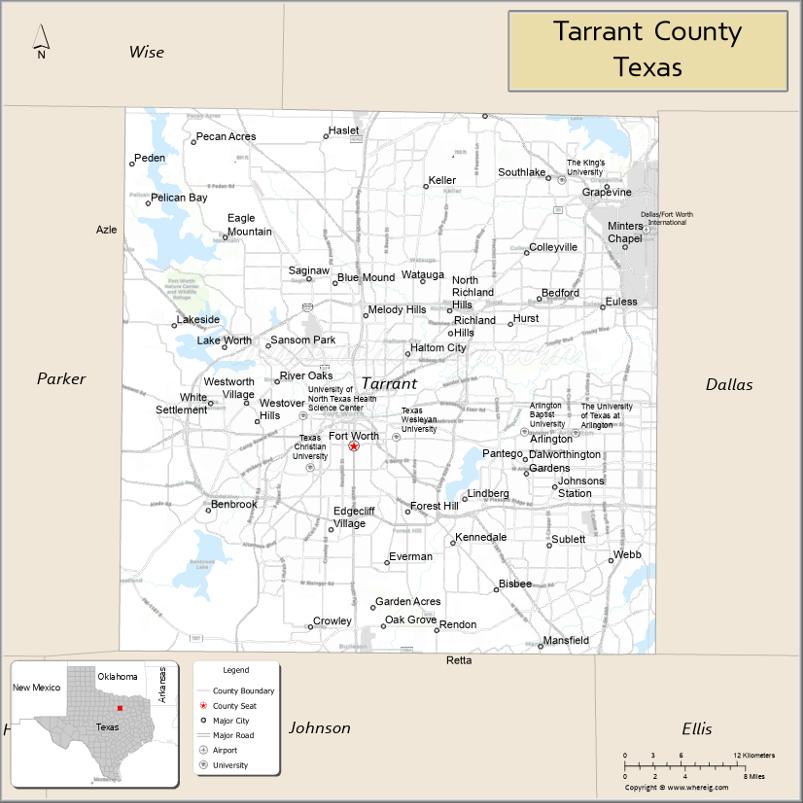
About Tarrant County Map, Texas: The map showing the county boundary, county seat, major cities, highways, water bodies and neighbouring counties.
Related Texas Maps
Map of Tarrant County, Texas
Tarrant County is a county located in the U.S. state of Texas. It's county seat is Fort Worth. As per 2020 census, the population of Tarrant County is 2126477 people and population density is square miles. According to the United States Census Bureau, the county has a total area of 864 sq mi (2,238 km2). Tarrant County was established on 1849.
Facts about Tarrant County, Texas
| Country | United States |
| State | Texas |
| Region | North Texas / Dallas–Fort Worth Metroplex |
| County Seat | Fort Worth |
| Named After | Edward H. Tarrant, Texas Ranger and politician |
| Established | 1849 |
| Organized | 1850 |
| Coordinates | 32.7688° N, 97.3095° W |
| Total Area | 902 sq mi |
| Land Area | 864 sq mi |
| Water Area | 38 sq mi |
| Population (2020) | 2,110,640 |
| Population Rank | One of the most populous counties in Texas |
| Major City | Fort Worth |
| Main Industries | Aerospace, Healthcare, Manufacturing, Finance, Transportation |
| Major Airport | Dallas/Fort Worth International Airport (DFW) |
| Time Zone | Central Time (UTC−06:00) |
| Known For | Fort Worth Stockyards, Cultural District, Major transportation hub |
| Website | https://www.tarrantcountytx.gov |
Top Attractions in Tarrant County, Texas
- Fort Worth Stockyards – Historic cattle drives and shops.
- Fort Worth Zoo – One of the nation’s top zoos.
- Kimbell Art Museum – World-class art collections.
- Fort Worth Botanic Garden – Beautiful themed gardens.
- Sundance Square – Downtown shopping and dining.
- Modern Art Museum of Fort Worth – Contemporary art exhibits.
- AT&T Stadium – Home of the Dallas Cowboys.
- Six Flags Over Texas – Major theme park attractions.
- Texas Motor Speedway – NASCAR races and events.
- Trinity Trails – Walking and biking along the river.
Cities and Towns in Tarrant County, Texas
| Place | Type | Population (Census 2020) | Latitude & Longitude |
|---|---|---|---|
| Fort Worth (county seat) | City | 918915 | 32.7555°N, 97.3308°W |
| Arlington | City | 394266 | 32.7357°N, 97.1081°W |
| North Richland Hills | City | 69917 | 32.8343°N, 97.2289°W |
| Euless | City | 61132 | 32.8371°N, 97.0819°W |
| Bedford | City | 49928 | 32.8440°N, 97.1431°W |
| Grapevine | City | 50091 | 32.9343°N, 97.0781°W |
| Southlake | City | 31754 | 32.9412°N, 97.1342°W |
| Colleyville | City | 26457 | 32.8809°N, 97.1550°W |
| Keller | City | 45576 | 32.9343°N, 97.2517°W |
| Hurst | City | 40313 | 32.8235°N, 97.1706°W |
| Mansfield (partly in Ellis and Johnson counties) | City | 72835 | 32.5632°N, 97.1417°W |
| Benbrook | City | 23973 | 32.6732°N, 97.4606°W |
| Burleson (partly in Johnson County) | City | 48587 | 32.5421°N, 97.3208°W |
| Crowley | City | 18670 | 32.5790°N, 97.3625°W |
| Forest Hill | City | 13717 | 32.6618°N, 97.2692°W |
| Haltom City | City | 44458 | 32.7996°N, 97.2692°W |
| Lake Worth | City | 4940 | 32.8043°N, 97.4450°W |
| Richland Hills | City | 8415 | 32.8154°N, 97.2286°W |
| River Oaks | City | 7663 | 32.7768°N, 97.3961°W |
| Saginaw | City | 24610 | 32.8601°N, 97.3639°W |
| Watauga | City | 24629 | 32.8579°N, 97.2547°W |
| Westworth Village | City | 2942 | 32.7551°N, 97.4147°W |
| White Settlement | City | 17389 | 32.7596°N, 97.4584°W |
| Blue Mound | City | 2475 | 32.8568°N, 97.3389°W |
| Dalworthington Gardens | City | 2259 | 32.6982°N, 97.1556°W |
| Edgecliff Village | Town | 2915 | 32.6576°N, 97.3428°W |
| Haslet | City | 1962 | 32.9740°N, 97.3472°W |
| Newark | City | 1366 | 33.0115°N, 97.4889°W |
| Pantego | Town | 2484 | 32.7146°N, 97.1567°W |
| Pelican Bay | City | 2099 | 32.9221°N, 97.5297°W |
| Rendon | Census Designated Place (CDP) | 12716 | 32.5768°N, 97.2419°W |
| Everman | City | 6206 | 32.6307°N, 97.2892°W |
| Kennedale | City | 8500 | 32.6460°N, 97.2253°W |
| Lakeside | Town | 1307 | 32.8215°N, 97.4939°W |
| Trophy Club (partly in Denton County) | Town | 12742 | 32.9979°N, 97.1836°W |
| Westlake (partly in Denton County) | Town | 1906 | 32.9912°N, 97.1944°W |
What are Major Roads and Highways in Tarrant County
Major highways connect the county to nearby regions and cities.
- Interstate 20 - east-west route connecting Arlington, Fort Worth, Dallas, and West Texas
- Interstate 30 - major corridor linking Fort Worth and Arlington with Dallas
- Interstate 35W - north-south route connecting Fort Worth with Denton and Hillsboro
- Interstate 820 - beltway around Fort Worth
- State Highway 121 - connects Fort Worth, Grapevine, and DFW Airport
- State Highway 114 - links Southlake, Grapevine, and Dallas
- State Highway 183 - major route through the Mid-Cities area
- State Highway 360 - north-south corridor through Arlington and Grand Prairie
- U.S. Highway 287 - connects Fort Worth with Wichita Falls and Southeast Texas
- Chisholm Trail Parkway - toll road connecting Fort Worth and Johnson County
What are Neighboring Counties of Tarrant County
- Denton County (north)
- Dallas County (east)
- Ellis County (southeast)
- Johnson County (south)
- Parker County (west)
- Wise County (northwest)
Distance from Tarrant County to Nearby Cities
The following distances are measured by road (driving).
- Fort Worth to Arlington (Tarrant County), Texas - 15 mi (24 km)
- Fort Worth to Grapevine (Tarrant County), Texas - 24 mi (39 km)
- Fort Worth to Keller (Tarrant County), Texas - 17 mi (27 km)
- Fort Worth to Mansfield (Tarrant County), Texas - 20 mi (32 km)
- Fort Worth to Denton (Denton County), Texas - 39 mi (63 km)
- Fort Worth to Dallas (Dallas County), Texas - 33 mi (53 km)
- Fort Worth to Waxahachie (Ellis County), Texas - 42 mi (68 km)
- Fort Worth to Cleburne (Johnson County), Texas - 31 mi (50 km)
- Fort Worth to Weatherford (Parker County), Texas - 28 mi (45 km)
- Fort Worth to Decatur (Wise County), Texas - 39 mi (63 km)
- Fort Worth to McKinney (Collin County), Texas - 58 mi (93 km)
- Fort Worth to Denton (Denton County), Texas - 39 mi (63 km)
- Fort Worth to Waco (McLennan County), Texas - 89 mi (143 km)
- Fort Worth to Wichita Falls (Wichita County), Texas - 114 mi (183 km)
- Fort Worth to Austin (Travis County), Texas - 190 mi (306 km)
Waterbodies in Tarrant County
Trinity River, West Fork Trinity River, Clear Fork Trinity River, Eagle Mountain Lake, Lake Worth, Benbrook Lake, Marine Creek Lake, Grapevine Lake, Village Creek, Sycamore Creek, Walnut Creek, Rush Creek, Lake Arlington, Mountain Creek Lake
Best Golf Courses in Tarrant County, Texas
| Golf Course | Location | Latitude & Longitude |
|---|---|---|
| Colonial Country Club | Fort Worth | 32.7239°N, 97.3618°W |
| Shady Oaks Country Club | Westworth Village | 32.7538°N, 97.4224°W |
| Mira Vista Country Club | Fort Worth | 32.6617°N, 97.4334°W |
| Ridglea Country Club | Fort Worth | 32.7245°N, 97.4430°W |
| Texas Star Golf Course | Euless | 32.8401°N, 97.0979°W |
| Waterchase Golf Club | Fort Worth | 32.7635°N, 97.1893°W |
| Bear Creek Golf Club | Dallas/Fort Worth Airport Area | 32.8979°N, 97.0465°W |
| Iron Horse Golf Course | North Richland Hills | 32.8828°N, 97.2488°W |
| Fossil Creek Golf Club | Fort Worth | 32.8756°N, 97.3017°W |
| Sky Creek Ranch Golf Club | Keller | 32.9346°N, 97.2468°W |
| Riverside Golf Club | Fort Worth | 32.7918°N, 97.2947°W |
| Meadowbrook Golf Course | Fort Worth | 32.7408°N, 97.2574°W |
| Lake Arlington Golf Course | Arlington | 32.6967°N, 97.1925°W |
| Tierra Verde Golf Club | Arlington | 32.6176°N, 97.1167°W |
| Walnut Creek Country Club | Mansfield | 32.5694°N, 97.1368°W |
| Squaw Creek Golf Course | Willow Park/Fort Worth Area | 32.7602°N, 97.4968°W |
Colleges and Universities in Tarrant County, Texas
| Institution Name | Type (Public/Private) | Level | Notable For |
|---|---|---|---|
| Texas Christian University | Private | University | Major private research university |
| University of Texas at Arlington | Public | University | Large public research institution |
| Tarrant County College | Public | Community College | Large multi-campus community college system |
| Texas Wesleyan University | Private | University | Private liberal arts university |
| University of North Texas Health Science Center | Public | University | Graduate health sciences education |
| Parker University | Private | University | Health sciences and chiropractic programs |
| Remington College - Fort Worth Campus | Private | College | Career and technical education |
References
- U.S. Census Bureau - 2020 Census Data for Tarrant County and Municipalities
- U.S. Census Bureau QuickFacts - Tarrant County
- Official Tarrant County Website
- North Central Texas Council of Governments
- USGS Geographic Names Information System (GNIS)
- Anderson County Map
- Andrews County Map
- Angelina County Map
- Aransas County Map
- Archer County Map
- Armstrong County Map
- Atascosa County Map
- Austin County Map
- Bailey County Map
- Bandera County Map
- Bastrop County Map
- Baylor County Map
- Bee County Map
- Bell County Map
- Bexar County Map
- Blanco County Map
- Borden County Map
- Bosque County Map
- Bowie County Map
- Brazoria County Map
- Brazos County Map
- Brewster County Map
- Briscoe County Map
- Brooks County Map
- Brown County Map
- Burleson County Map
- Burnet County Map
- Caldwell County Map
- Calhoun County Map
- Callahan County Map
- Cameron County Map
- Camp County Map
- Carson County Map
- Cass County Map
- Castro County Map
- Chambers County Map
- Cherokee County Map
- Childress County Map
- Clay County Map
- Cochran County Map
- Coke County Map
- Coleman County Map
- Collin County Map
- Collingsworth County Map
- Colorado County Map
- Comal County Map
- Comanche County Map
- Concho County Map
- Cooke County Map
- Coryell County Map
- Cottle County Map
- Crane County Map
- Crockett County Map
- Crosby County Map
- Culberson County Map
- Dallam County Map
- Dallas County Map
- Dawson County Map
- Deaf Smith County Map
- Delta County Map
- Denton County Map
- DeWitt County Map
- Dickens County Map
- Dimmit County Map
- Donley County Map
- Duval County Map
- Eastland County Map
- Ector County Map
- Edwards County Map
- Ellis County Map
- El Paso County Map
- Erath County Map
- Falls County Map
- Fannin County Map
- Fayette County Map
- Fisher County Map
- Floyd County Map
- Foard County Map
- Fort Bend County Map
- Franklin County Map
- Freestone County Map
- Frio County Map
- Gaines County Map
- Galveston County Map
- Garza County Map
- Gillespie County Map
- Glasscock County Map
- Goliad County Map
- Gonzales County Map
- Gray County Map
- Grayson County Map
- Gregg County Map
- Grimes County Map
- Guadalupe County Map
- Hale County Map
- Hall County Map
- Hamilton County Map
- Hansford County Map
- Hardeman County Map
- Hardin County Map
- Harris County Map
- Harrison County Map
- Hartley County Map
- Haskell County Map
- Hays County Map
- Hemphill County Map
- Henderson County Map
- Hidalgo County Map
- Hill County Map
- Hockley County Map
- Hood County Map
- Hopkins County Map
- Houston County Map
- Howard County Map
- Hudspeth County Map
- Hunt County Map
- Hutchinson County Map
- Irion County Map
- Jack County Map
- Jackson County Map
- Jasper County Map
- Jeff Davis County Map
- Jefferson County Map
- Jim Hogg County Map
- Jim Wells County Map
- Johnson County Map
- Jones County Map
- Karnes County Map
- Kaufman County Map
- Kendall County Map
- Kenedy County Map
- Kent County Map
- Kerr County Map
- Kimble County Map
- King County Map
- Kinney County Map
- Kleberg County Map
- Knox County Map
- Lamar County Map
- Lamb County Map
- Lampasas County Map
- La Salle County Map
- Lavaca County Map
- Lee County Map
- Leon County Map
- Liberty County Map
- Limestone County Map
- Lipscomb County Map
- Live Oak County Map
- Llano County Map
- Loving County Map
- Lubbock County Map
- Lynn County Map
- McCulloch County Map
- McLennan County Map
- McMullen County Map
- Madison County Map
- Marion County Map
- Martin County Map
- Mason County Map
- Matagorda County Map
- Maverick County Map
- Medina County Map
- Menard County Map
- Midland County Map
- Milam County Map
- Mills County Map
- Mitchell County Map
- Montague County Map
- Montgomery County Map
- Moore County Map
- Morris County Map
- Motley County Map
- Nacogdoches County Map
- Navarro County Map
- Newton County Map
- Nolan County Map
- Nueces County Map
- Ochiltree County Map
- Oldham County Map
- Orange County Map
- Palo Pinto County Map
- Panola County Map
- Parker County Map
- Parmer County Map
- Pecos County Map
- Polk County Map
- Potter County Map
- Presidio County Map
- Rains County Map
- Randall County Map
- Reagan County Map
- Real County Map
- Red River County Map
- Reeves County Map
- Refugio County Map
- Roberts County Map
- Robertson County Map
- Rockwall County Map
- Runnels County Map
- Rusk County Map
- Sabine County Map
- San Augustine County Map
- San Jacinto County Map
- San Patricio County Map
- San Saba County Map
- Schleicher County Map
- Scurry County Map
- Shackelford County Map
- Shelby County Map
- Sherman County Map
- Smith County Map
- Somervell County Map
- Starr County Map
- Stephens County Map
- Sterling County Map
- Stonewall County Map
- Sutton County Map
- Swisher County Map
- Tarrant County Map
- Taylor County Map
- Terrell County Map
- Terry County Map
- Throckmorton County Map
- Titus County Map
- Tom Green County Map
- Travis County Map
- Trinity County Map
- Tyler County Map
- Upshur County Map
- Upton County Map
- Uvalde County Map
- Val Verde County Map
- Van Zandt County Map
- Victoria County Map
- Walker County Map
- Waller County Map
- Ward County Map
- Washington County Map
- Webb County Map
- Wharton County Map
- Wheeler County Map
- Wichita County Map
- Wilbarger County Map
- Willacy County Map
- Williamson County Map
- Wilson County Map
- Winkler County Map
- Wise County Map
- Wood County Map
- Yoakum County Map
- Young County Map
- Zapata County Map
- Zavala County Map
- Alabama Counties
- Alaska boroughs
- Arizona Counties
- Arkansas Counties
- California County Map
- Colorado Counties
- Connecticut Counties
- Delaware Counties
- Florida County Map
- Georgia County Map
- Hawaii Counties
- Idaho Counties
- Illinois Counties
- Indiana Counties
- Iowa Counties
- Kansas Counties
- Kentucky Counties
- Louisiana Counties
- Maine Counties
- Maryland Counties
- Massachusetts Counties
- Michigan County Map
- Minnesota Counties
- Mississippi Counties
- Missouri Counties
- Montana Counties
- Nebraska Counties
- Nevada Counties
- New York Counties
- New Hampshire Counties
- New Jersey Counties
- New Mexico Counties
- North Carolina Counties
- North Dakota Counties
- Ohio County Map
- Oklahoma Counties
- Oregon Counties
- Pennsylvania Counties
- Rhode Island Counties
- South Carolina Counties
- South Dakota Counties
- Map of Tennessee
- Texas County Map
- Utah Counties
- Vermont Counties
- Virginia Counties
- Washington Counties
- West Virginia Counties
- Wisconsin Counties
- Wyoming Counties
References
- ^ QuickFacts: Tarrant County, Texas - United States Census Bureau
- ^ United States Census Bureau - Population and Housing Data
- ^ TIGER/Line Shapefiles - United States Census Bureau
- ^ United States Geological Survey (USGS)
- ^ National Geodetic Survey (NGS), NOAA
- ^ Official Website of Tarrant County, Texas
- ^ Texas Department of Transportation (TxDOT)