Map of Houston County - Houston County is a county located in the U.S. state of Texas. Houston County Map showing cities, highways, important places and water bodies. Get Where is Houston County located in the map, major cities in Houston county, population, areas, and places of interest.
Map of Houston County, Texas
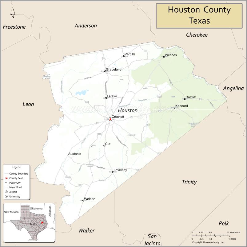
About Houston County Map, Texas: The map showing the county boundary, county seat, major cities, highways, water bodies and neighbouring counties.
Related Texas Maps
Map of Houston County, Texas
Houston County is a county located in the U.S. state of Texas. It's county seat is Crockett. As per 2020 census, the population of Houston County is 22241 people and population density is square miles. According to the United States Census Bureau, the county has a total area of 1,231 sq mi (3,188 km2). Houston County was established on 1837.
Facts about Houston County, Texas
| Country | United States |
| State | Texas |
| Region | East Texas / Piney Woods |
| County Seat | Crockett |
| Named After | Sam Houston, first president of the Republic of Texas |
| Established | 1837 |
| Organized | 1837 |
| Coordinates | 31.3000° N, 95.4560° W |
| Total Area | 1,099 sq mi |
| Land Area | 1,090 sq mi |
| Water Area | 9 sq mi |
| Population (2020) | 22,022 |
| Population Rank | Moderately populated East Texas county |
| Major Cities | Crockett, Kennard, Grapeland |
| Main Industries | Timber, Agriculture, Oil & Gas, Manufacturing |
| Major Airport | Crockett Municipal Airport |
| Time Zone | Central Time (UTC−06:00) |
| Known For | Sam Houston Memorial Museum, Piney Woods forests, Crockett Lake, Rural East Texas culture |
| Website | https://www.co.houston.tx.us |
Top Attractions in Houston County, Texas
- Davy Crockett National Forest – Hiking, camping, and scenic trails in East Texas forest.
- Lake Livingston State Park (Nearby Access) – Boating, fishing, and lakeside recreation.
- Historic Crockett Downtown – Shops, cafés, and preserved 19th-century architecture.
- Houston County Courthouse – Landmark courthouse anchoring downtown Crockett.
- Heritage Hall Museum – Exhibits on pioneer life, local culture, and East Texas history.
- Crockett City Park – Playground, picnic areas, and family-friendly recreation space.
- Caney Creek Wilderness Area – Nature trails and outdoor exploration opportunities.
- Historic Churches of Crockett – Beautiful preserved architecture reflecting county heritage.
- Scenic East Texas Drives – Forested roads and rolling hills ideal for photography.
- Local Timberland Sites – Historic logging landmarks and forest exploration.
Cities and Towns in Houston County, Texas
| Place | Type | Population (Census 2020) | Latitude & Longitude |
|---|---|---|---|
| Crockett (county seat) | City | 6332 | 31.3182°N, 95.4569°W |
| Grapeland | City | 1148 | 31.4910°N, 95.4788°W |
| Lovelady | City | 573 | 31.1252°N, 95.4458°W |
| Kennard | Town | 277 | 31.3613°N, 95.1866°W |
| Latexo | Town | 322 | 31.3968°N, 95.4780°W |
| Ratcliff | Town | 85 | 31.4018°N, 95.1435°W |
| Austonio | Unincorporated Community | N/A | 31.5983°N, 95.3449°W |
| Percilla | Unincorporated Community | N/A | 31.5471°N, 95.3233°W |
| Porter Springs | Unincorporated Community | N/A | 31.3482°N, 95.0994°W |
| Belott | Unincorporated Community | N/A | 31.2179°N, 95.5852°W |
What are Major Roads and Highways in Houston County
- U.S. Highway 287 - major north-south corridor through Crockett
- Texas State Highway 7 - east-west route connecting Crockett with Nacogdoches and Centerville
- Texas State Highway 19 - links Crockett with Palestine and Trinity County
- Texas State Highway 21 - follows the historic El Camino Real de los Tejas route
- Farm to Market Road 2022 - serves eastern Houston County communities
- Farm to Market Road 227 - connects Grapeland with rural areas
- Farm to Market Road 232 - serves agricultural and forested sections of the county
What are Neighboring Counties of Houston County
- Anderson County (north)
- Cherokee County (northeast)
- Angelina County (east)
- Trinity County (south)
- Walker County (southwest)
- Madison County (west)
- Leon County (northwest)
Distance from Houston County to Nearby Cities
| City | Distance (km) | Distance (mi) |
|---|---|---|
| Grapeland | 24 | 15 |
| Lovelady | 31 | 19 |
| Kennard | 32 | 20 |
| Palestine (Anderson County) | 58 | 36 |
| Lufkin (Angelina County) | 72 | 45 |
| Trinity (Trinity County) | 58 | 36 |
| Huntsville (Walker County) | 78 | 48 |
| Madisonville (Madison County) | 86 | 53 |
| Jacksonville (Cherokee County) | 80 | 50 |
| Buffalo (Leon County) | 79 | 49 |
| Nacogdoches (Nacogdoches County) | 95 | 59 |
| College Station (Brazos County) | 133 | 83 |
| Tyler (Smith County) | 144 | 89 |
| Houston (Harris County) | 190 | 118 |
| Dallas (Dallas County) | 275 | 171 |
Waterbodies in Houston County
Neches River, Trinity River, Houston County Lake, Grapeland City Lake, White Rock Creek, Elkhart Creek, Hurricane Creek, San Pedro Creek, Big Elkhart Creek, wetlands, forest streams, farm ponds, reservoirs, springs, and seasonal waterways
Best Golf Courses in Houston County, Texas
| Golf Course | Location | Latitude & Longitude |
|---|---|---|
| Spring Creek Country Club | Crockett | 31.3173°N, 95.4678°W |
| Pine Dunes Golf Club | Frankston | 32.0749°N, 95.4763°W |
| Ratcliff Lake Recreation Area Golf Facilities | Ratcliff Area | 31.3967°N, 95.1548°W |
Colleges and Universities in Houston County, Texas
| Institution Name | Type | Level | Notable For |
|---|---|---|---|
| Angelina College | Public | Community College | Community college services for Houston County residents |
| Stephen F. Austin State University | Public | University | Major regional university in nearby Nacogdoches |
| Sam Houston State University | Public | University | Public university in nearby Huntsville |
| Texas A&M AgriLife Extension Service - Houston County | Public | University | Agricultural and community education programs |
References
- U.S. Census Bureau - Houston County QuickFacts
- Official Houston County Website
- Texas State Historical Association - Houston County
- Texas Almanac - Houston County
- Angelina College
- Anderson County Map
- Andrews County Map
- Angelina County Map
- Aransas County Map
- Archer County Map
- Armstrong County Map
- Atascosa County Map
- Austin County Map
- Bailey County Map
- Bandera County Map
- Bastrop County Map
- Baylor County Map
- Bee County Map
- Bell County Map
- Bexar County Map
- Blanco County Map
- Borden County Map
- Bosque County Map
- Bowie County Map
- Brazoria County Map
- Brazos County Map
- Brewster County Map
- Briscoe County Map
- Brooks County Map
- Brown County Map
- Burleson County Map
- Burnet County Map
- Caldwell County Map
- Calhoun County Map
- Callahan County Map
- Cameron County Map
- Camp County Map
- Carson County Map
- Cass County Map
- Castro County Map
- Chambers County Map
- Cherokee County Map
- Childress County Map
- Clay County Map
- Cochran County Map
- Coke County Map
- Coleman County Map
- Collin County Map
- Collingsworth County Map
- Colorado County Map
- Comal County Map
- Comanche County Map
- Concho County Map
- Cooke County Map
- Coryell County Map
- Cottle County Map
- Crane County Map
- Crockett County Map
- Crosby County Map
- Culberson County Map
- Dallam County Map
- Dallas County Map
- Dawson County Map
- Deaf Smith County Map
- Delta County Map
- Denton County Map
- DeWitt County Map
- Dickens County Map
- Dimmit County Map
- Donley County Map
- Duval County Map
- Eastland County Map
- Ector County Map
- Edwards County Map
- Ellis County Map
- El Paso County Map
- Erath County Map
- Falls County Map
- Fannin County Map
- Fayette County Map
- Fisher County Map
- Floyd County Map
- Foard County Map
- Fort Bend County Map
- Franklin County Map
- Freestone County Map
- Frio County Map
- Gaines County Map
- Galveston County Map
- Garza County Map
- Gillespie County Map
- Glasscock County Map
- Goliad County Map
- Gonzales County Map
- Gray County Map
- Grayson County Map
- Gregg County Map
- Grimes County Map
- Guadalupe County Map
- Hale County Map
- Hall County Map
- Hamilton County Map
- Hansford County Map
- Hardeman County Map
- Hardin County Map
- Harris County Map
- Harrison County Map
- Hartley County Map
- Haskell County Map
- Hays County Map
- Hemphill County Map
- Henderson County Map
- Hidalgo County Map
- Hill County Map
- Hockley County Map
- Hood County Map
- Hopkins County Map
- Houston County Map
- Howard County Map
- Hudspeth County Map
- Hunt County Map
- Hutchinson County Map
- Irion County Map
- Jack County Map
- Jackson County Map
- Jasper County Map
- Jeff Davis County Map
- Jefferson County Map
- Jim Hogg County Map
- Jim Wells County Map
- Johnson County Map
- Jones County Map
- Karnes County Map
- Kaufman County Map
- Kendall County Map
- Kenedy County Map
- Kent County Map
- Kerr County Map
- Kimble County Map
- King County Map
- Kinney County Map
- Kleberg County Map
- Knox County Map
- Lamar County Map
- Lamb County Map
- Lampasas County Map
- La Salle County Map
- Lavaca County Map
- Lee County Map
- Leon County Map
- Liberty County Map
- Limestone County Map
- Lipscomb County Map
- Live Oak County Map
- Llano County Map
- Loving County Map
- Lubbock County Map
- Lynn County Map
- McCulloch County Map
- McLennan County Map
- McMullen County Map
- Madison County Map
- Marion County Map
- Martin County Map
- Mason County Map
- Matagorda County Map
- Maverick County Map
- Medina County Map
- Menard County Map
- Midland County Map
- Milam County Map
- Mills County Map
- Mitchell County Map
- Montague County Map
- Montgomery County Map
- Moore County Map
- Morris County Map
- Motley County Map
- Nacogdoches County Map
- Navarro County Map
- Newton County Map
- Nolan County Map
- Nueces County Map
- Ochiltree County Map
- Oldham County Map
- Orange County Map
- Palo Pinto County Map
- Panola County Map
- Parker County Map
- Parmer County Map
- Pecos County Map
- Polk County Map
- Potter County Map
- Presidio County Map
- Rains County Map
- Randall County Map
- Reagan County Map
- Real County Map
- Red River County Map
- Reeves County Map
- Refugio County Map
- Roberts County Map
- Robertson County Map
- Rockwall County Map
- Runnels County Map
- Rusk County Map
- Sabine County Map
- San Augustine County Map
- San Jacinto County Map
- San Patricio County Map
- San Saba County Map
- Schleicher County Map
- Scurry County Map
- Shackelford County Map
- Shelby County Map
- Sherman County Map
- Smith County Map
- Somervell County Map
- Starr County Map
- Stephens County Map
- Sterling County Map
- Stonewall County Map
- Sutton County Map
- Swisher County Map
- Tarrant County Map
- Taylor County Map
- Terrell County Map
- Terry County Map
- Throckmorton County Map
- Titus County Map
- Tom Green County Map
- Travis County Map
- Trinity County Map
- Tyler County Map
- Upshur County Map
- Upton County Map
- Uvalde County Map
- Val Verde County Map
- Van Zandt County Map
- Victoria County Map
- Walker County Map
- Waller County Map
- Ward County Map
- Washington County Map
- Webb County Map
- Wharton County Map
- Wheeler County Map
- Wichita County Map
- Wilbarger County Map
- Willacy County Map
- Williamson County Map
- Wilson County Map
- Winkler County Map
- Wise County Map
- Wood County Map
- Yoakum County Map
- Young County Map
- Zapata County Map
- Zavala County Map
- Alabama Counties
- Alaska boroughs
- Arizona Counties
- Arkansas Counties
- California County Map
- Colorado Counties
- Connecticut Counties
- Delaware Counties
- Florida County Map
- Georgia County Map
- Hawaii Counties
- Idaho Counties
- Illinois Counties
- Indiana Counties
- Iowa Counties
- Kansas Counties
- Kentucky Counties
- Louisiana Counties
- Maine Counties
- Maryland Counties
- Massachusetts Counties
- Michigan County Map
- Minnesota Counties
- Mississippi Counties
- Missouri Counties
- Montana Counties
- Nebraska Counties
- Nevada Counties
- New York Counties
- New Hampshire Counties
- New Jersey Counties
- New Mexico Counties
- North Carolina Counties
- North Dakota Counties
- Ohio County Map
- Oklahoma Counties
- Oregon Counties
- Pennsylvania Counties
- Rhode Island Counties
- South Carolina Counties
- South Dakota Counties
- Map of Tennessee
- Texas County Map
- Utah Counties
- Vermont Counties
- Virginia Counties
- Washington Counties
- West Virginia Counties
- Wisconsin Counties
- Wyoming Counties
References
- ^ QuickFacts: Houston County, Texas - United States Census Bureau
- ^ United States Census Bureau - Population and Housing Data
- ^ TIGER/Line Shapefiles - United States Census Bureau
- ^ United States Geological Survey (USGS)
- ^ National Geodetic Survey (NGS), NOAA
- ^ Official Website of Houston County, Texas
- ^ Texas Department of Transportation (TxDOT)