Map of Bexar County - Bexar County is a county located in the U.S. state of Texas. Bexar County Map showing cities, highways, important places and water bodies. Get Where is Bexar County located in the map, major cities in Bexar county, population, areas, and places of interest.
Map of Bexar County, Texas
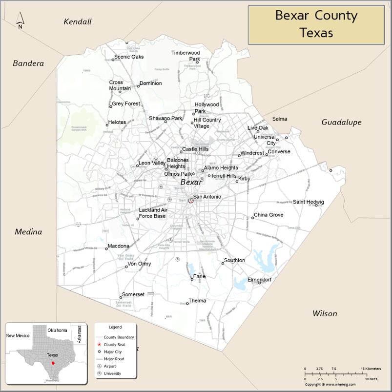
About Bexar County Map, Texas: The map showing the county boundary, county seat, major cities, highways, water bodies and neighbouring counties.
Related Texas Maps
Map of Bexar County, Texas
Bexar County is a county located in the U.S. state of Texas. It's county seat is San Antonio. As per 2020 census, the population of Bexar County is 2028236 people and population density is square miles. According to the United States Census Bureau, the county has a total area of 1,247 sq mi (3,230 km2). Bexar County was established on 1836.
Facts about Bexar County, Texas
| Country | United States |
| State | Texas |
| Region | South Central Texas |
| County Seat | San Antonio |
| Named After | Presidio San Antonio de Béxar |
| Established | 1836 |
| Organized | 1837 |
| Coordinates | 29.4480° N, 98.5200° W |
| Total Area | 1,256 sq mi |
| Land Area | 1,240 sq mi |
| Water Area | 16 sq mi |
| Population (2020) | 2 million |
| Population Rank | 4th most populous county in Texas |
| Major City | San Antonio |
| Main Industries | Military, Tourism, Healthcare, Cybersecurity, Finance |
| Major Airport | San Antonio International Airport |
| Time Zone | Central Time (UTC−06:00) |
| Known For | The Alamo, River Walk, Military bases, Rich cultural heritage |
| Website | https://www.bexar.org |
Top Attractions in Bexar County, Texas
- The Alamo – Iconic Texas Revolution mission and museum.
- San Antonio River Walk – Scenic riverside paths lined with shops and dining.
- San Antonio Missions National Historical Park – Preserved Spanish missions and cultural history.
- San Antonio Zoo – Large zoo with global wildlife exhibits.
- San Antonio Museum of Art – Wide-ranging art collections in a historic brewery building.
- Japanese Tea Garden – Peaceful garden with koi ponds and stone pathways.
- Tower of the Americas – Observation tower offering panoramic city views.
- Six Flags Fiesta Texas – Theme park with coasters, shows, and water rides.
- Natural Bridge Caverns – Underground cave tours and adventure attractions.
- Pearl District – Trendy area with shops, restaurants, and a weekend market.
Cities and Towns in Bexar County, Texas
| Place | Type | Population (Census 2020) | Latitude & Longitude |
|---|---|---|---|
| San Antonio (county seat) | City | 1434625 | 29.4241°N, 98.4936°W |
| Alamo Heights | City | 7373 | 29.4841°N, 98.4659°W |
| Balcones Heights | City | 2983 | 29.4880°N, 98.5511°W |
| Castle Hills | City | 4116 | 29.5236°N, 98.5164°W |
| China Grove | City | 1128 | 29.3975°N, 98.3406°W |
| Converse | City | 27197 | 29.5180°N, 98.3161°W |
| Elmendorf | City | 1488 | 29.2547°N, 98.3731°W |
| Grey Forest | City | 405 | 29.5858°N, 98.6200°W |
| Helotes | City | 9341 | 29.5780°N, 98.6897°W |
| Hill Country Village | City | 1042 | 29.5833°N, 98.5261°W |
| Hollywood Park | Town | 3026 | 29.5955°N, 98.4878°W |
| Kirby | City | 8297 | 29.4608°N, 98.3850°W |
| Leon Valley | City | 10719 | 29.4952°N, 98.6181°W |
| Live Oak | City | 16056 | 29.5513°N, 98.3395°W |
| Olmos Park | City | 2237 | 29.4877°N, 98.4875°W |
| Shavano Park | City | 4035 | 29.5833°N, 98.5525°W |
| Terrell Hills | City | 5104 | 29.4797°N, 98.4439°W |
| Von Ormy | City | 1200 | 29.2897°N, 98.6470°W |
| Windcrest | City | 6018 | 29.5152°N, 98.3806°W |
| Adkins | Census Designated Place (CDP) | 2760 | 29.3419°N, 98.2558°W |
| Cross Mountain | Census Designated Place (CDP) | 3379 | 29.6455°N, 98.6911°W |
| Lackland AFB | Census Designated Place (CDP) | 6991 | 29.3845°N, 98.6178°W |
| Timberwood Park | Census Designated Place (CDP) | 24887 | 29.6391°N, 98.4764°W |
| Macdona | Unincorporated Community | N/A | 29.3252°N, 98.6947°W |
| Somerset | Unincorporated Community | N/A | 29.2269°N, 98.6578°W |
What are Major Roads and Highways in Bexar County
Major highways connect the county to nearby regions and cities.
- Interstate 10 - east toward Houston and west toward El Paso
- Interstate 35 - north toward Austin and Dallas-Fort Worth, south toward Laredo
- Interstate 37 - southeast toward Corpus Christi
- Interstate 410 - loop around San Antonio
- Loop 1604 - outer loop serving the San Antonio metropolitan area
- U.S. Highway 90 - west toward Uvalde and east toward Seguin
- U.S. Highway 281 - north toward Blanco and south toward George West
- Texas State Highway 151 - serves western San Antonio
- Texas State Highway 211 - connects western Bexar County communities
- Texas State Highway 16 - north toward Bandera and south toward Jourdanton
What are Neighboring Counties of Bexar County
- Comal County (north)
- Guadalupe County (east)
- Wilson County (southeast)
- Atascosa County (south)
- Medina County (west)
- Bandera County (northwest)
- Kendall County (northwest)
Distance from Bexar County to Nearby Cities
The following distances are measured by road (driving).
- San Antonio to New Braunfels (Comal County), Texas - 33 mi (53 km)
- San Antonio to Seguin (Guadalupe County), Texas - 36 mi (58 km)
- San Antonio to Floresville (Wilson County), Texas - 33 mi (53 km)
- San Antonio to Pleasanton (Atascosa County), Texas - 37 mi (60 km)
- San Antonio to Hondo (Medina County), Texas - 42 mi (68 km)
- San Antonio to Boerne (Kendall County), Texas - 31 mi (50 km)
- San Antonio to Bandera (Bandera County), Texas - 47 mi (76 km)
- San Antonio to Kerrville (Kerr County), Texas - 65 mi (105 km)
- San Antonio to Austin (Travis County), Texas - 80 mi (129 km)
- San Antonio to San Marcos (Hays County), Texas - 51 mi (82 km)
- San Antonio to Uvalde (Uvalde County), Texas - 83 mi (134 km)
- San Antonio to Corpus Christi (Nueces County), Texas - 144 mi (232 km)
- San Antonio to Laredo (Webb County), Texas - 156 mi (251 km)
- San Antonio to Houston (Harris County), Texas - 197 mi (317 km)
- San Antonio to Dallas (Dallas County), Texas - 274 mi (441 km)
Waterbodies in Bexar County
San Antonio River, Medina River, Leon Creek, Salado Creek, Cibolo Creek, Calaveras Lake, Braunig Lake, Elmendorf Lake, Mitchell Lake, Medina Lake watershed, Martinez Creek, Apache Creek, Olmos Creek, Leon Creek Greenway waterways, Upper San Antonio River watershed, springs, wetlands, reservoirs, and flood-control lakes
Best Golf Courses in Bexar County, Texas
| Golf Course | Location | Latitude & Longitude |
|---|---|---|
| Brackenridge Park Golf Course | San Antonio | 29.4585°N, 98.4737°W |
| The Quarry Golf Course | San Antonio | 29.4904°N, 98.4676°W |
| SilverHorn Golf Club | San Antonio | 29.5609°N, 98.4705°W |
| Canyon Springs Golf Club | San Antonio | 29.6265°N, 98.4457°W |
| Hyatt Hill Country Golf Club | San Antonio | 29.4597°N, 98.6382°W |
| La Cantera Golf Club | San Antonio | 29.5968°N, 98.6157°W |
| Northern Hills Golf Club | San Antonio | 29.5497°N, 98.4079°W |
| Cedar Creek Golf Course | San Antonio | 29.3569°N, 98.4932°W |
| Mission Del Lago Golf Course | San Antonio | 29.2845°N, 98.4525°W |
| Republic Golf Club | San Antonio | 29.3577°N, 98.3974°W |
| Willow Springs Golf Course | San Antonio | 29.4029°N, 98.4492°W |
| Golf Club of Texas | San Antonio | 29.3624°N, 98.7326°W |
| TPC San Antonio | San Antonio | 29.6671°N, 98.4285°W |
| Olmos Basin Golf Course | San Antonio | 29.4928°N, 98.4818°W |
Colleges and Universities in Bexar County, Texas
| Institution Name | Type | Level | Notable For |
|---|---|---|---|
| University of Texas at San Antonio | Public | University | Largest public university in the county |
| Texas A&M University-San Antonio | Public | University | South Side higher education campus |
| Trinity University | Private | University | Liberal arts and research programs |
| St. Mary's University | Private | University | Catholic higher education institution |
| Our Lady of the Lake University | Private | University | Historic Catholic university |
| University of the Incarnate Word | Private | University | Largest Catholic university in Texas |
| Alamo Colleges District | Public | Community College | Multi-campus community college system |
| Hallmark University | Private | University | Aviation and technology programs |
References
- U.S. Census Bureau - Bexar County QuickFacts
- Official Bexar County Website
- Texas State Historical Association - Bexar County
- The University of Texas at San Antonio
- Texas Department of Transportation
- Anderson County Map
- Andrews County Map
- Angelina County Map
- Aransas County Map
- Archer County Map
- Armstrong County Map
- Atascosa County Map
- Austin County Map
- Bailey County Map
- Bandera County Map
- Bastrop County Map
- Baylor County Map
- Bee County Map
- Bell County Map
- Bexar County Map
- Blanco County Map
- Borden County Map
- Bosque County Map
- Bowie County Map
- Brazoria County Map
- Brazos County Map
- Brewster County Map
- Briscoe County Map
- Brooks County Map
- Brown County Map
- Burleson County Map
- Burnet County Map
- Caldwell County Map
- Calhoun County Map
- Callahan County Map
- Cameron County Map
- Camp County Map
- Carson County Map
- Cass County Map
- Castro County Map
- Chambers County Map
- Cherokee County Map
- Childress County Map
- Clay County Map
- Cochran County Map
- Coke County Map
- Coleman County Map
- Collin County Map
- Collingsworth County Map
- Colorado County Map
- Comal County Map
- Comanche County Map
- Concho County Map
- Cooke County Map
- Coryell County Map
- Cottle County Map
- Crane County Map
- Crockett County Map
- Crosby County Map
- Culberson County Map
- Dallam County Map
- Dallas County Map
- Dawson County Map
- Deaf Smith County Map
- Delta County Map
- Denton County Map
- DeWitt County Map
- Dickens County Map
- Dimmit County Map
- Donley County Map
- Duval County Map
- Eastland County Map
- Ector County Map
- Edwards County Map
- Ellis County Map
- El Paso County Map
- Erath County Map
- Falls County Map
- Fannin County Map
- Fayette County Map
- Fisher County Map
- Floyd County Map
- Foard County Map
- Fort Bend County Map
- Franklin County Map
- Freestone County Map
- Frio County Map
- Gaines County Map
- Galveston County Map
- Garza County Map
- Gillespie County Map
- Glasscock County Map
- Goliad County Map
- Gonzales County Map
- Gray County Map
- Grayson County Map
- Gregg County Map
- Grimes County Map
- Guadalupe County Map
- Hale County Map
- Hall County Map
- Hamilton County Map
- Hansford County Map
- Hardeman County Map
- Hardin County Map
- Harris County Map
- Harrison County Map
- Hartley County Map
- Haskell County Map
- Hays County Map
- Hemphill County Map
- Henderson County Map
- Hidalgo County Map
- Hill County Map
- Hockley County Map
- Hood County Map
- Hopkins County Map
- Houston County Map
- Howard County Map
- Hudspeth County Map
- Hunt County Map
- Hutchinson County Map
- Irion County Map
- Jack County Map
- Jackson County Map
- Jasper County Map
- Jeff Davis County Map
- Jefferson County Map
- Jim Hogg County Map
- Jim Wells County Map
- Johnson County Map
- Jones County Map
- Karnes County Map
- Kaufman County Map
- Kendall County Map
- Kenedy County Map
- Kent County Map
- Kerr County Map
- Kimble County Map
- King County Map
- Kinney County Map
- Kleberg County Map
- Knox County Map
- Lamar County Map
- Lamb County Map
- Lampasas County Map
- La Salle County Map
- Lavaca County Map
- Lee County Map
- Leon County Map
- Liberty County Map
- Limestone County Map
- Lipscomb County Map
- Live Oak County Map
- Llano County Map
- Loving County Map
- Lubbock County Map
- Lynn County Map
- McCulloch County Map
- McLennan County Map
- McMullen County Map
- Madison County Map
- Marion County Map
- Martin County Map
- Mason County Map
- Matagorda County Map
- Maverick County Map
- Medina County Map
- Menard County Map
- Midland County Map
- Milam County Map
- Mills County Map
- Mitchell County Map
- Montague County Map
- Montgomery County Map
- Moore County Map
- Morris County Map
- Motley County Map
- Nacogdoches County Map
- Navarro County Map
- Newton County Map
- Nolan County Map
- Nueces County Map
- Ochiltree County Map
- Oldham County Map
- Orange County Map
- Palo Pinto County Map
- Panola County Map
- Parker County Map
- Parmer County Map
- Pecos County Map
- Polk County Map
- Potter County Map
- Presidio County Map
- Rains County Map
- Randall County Map
- Reagan County Map
- Real County Map
- Red River County Map
- Reeves County Map
- Refugio County Map
- Roberts County Map
- Robertson County Map
- Rockwall County Map
- Runnels County Map
- Rusk County Map
- Sabine County Map
- San Augustine County Map
- San Jacinto County Map
- San Patricio County Map
- San Saba County Map
- Schleicher County Map
- Scurry County Map
- Shackelford County Map
- Shelby County Map
- Sherman County Map
- Smith County Map
- Somervell County Map
- Starr County Map
- Stephens County Map
- Sterling County Map
- Stonewall County Map
- Sutton County Map
- Swisher County Map
- Tarrant County Map
- Taylor County Map
- Terrell County Map
- Terry County Map
- Throckmorton County Map
- Titus County Map
- Tom Green County Map
- Travis County Map
- Trinity County Map
- Tyler County Map
- Upshur County Map
- Upton County Map
- Uvalde County Map
- Val Verde County Map
- Van Zandt County Map
- Victoria County Map
- Walker County Map
- Waller County Map
- Ward County Map
- Washington County Map
- Webb County Map
- Wharton County Map
- Wheeler County Map
- Wichita County Map
- Wilbarger County Map
- Willacy County Map
- Williamson County Map
- Wilson County Map
- Winkler County Map
- Wise County Map
- Wood County Map
- Yoakum County Map
- Young County Map
- Zapata County Map
- Zavala County Map
- Alabama Counties
- Alaska boroughs
- Arizona Counties
- Arkansas Counties
- California County Map
- Colorado Counties
- Connecticut Counties
- Delaware Counties
- Florida County Map
- Georgia County Map
- Hawaii Counties
- Idaho Counties
- Illinois Counties
- Indiana Counties
- Iowa Counties
- Kansas Counties
- Kentucky Counties
- Louisiana Counties
- Maine Counties
- Maryland Counties
- Massachusetts Counties
- Michigan County Map
- Minnesota Counties
- Mississippi Counties
- Missouri Counties
- Montana Counties
- Nebraska Counties
- Nevada Counties
- New York Counties
- New Hampshire Counties
- New Jersey Counties
- New Mexico Counties
- North Carolina Counties
- North Dakota Counties
- Ohio County Map
- Oklahoma Counties
- Oregon Counties
- Pennsylvania Counties
- Rhode Island Counties
- South Carolina Counties
- South Dakota Counties
- Map of Tennessee
- Texas County Map
- Utah Counties
- Vermont Counties
- Virginia Counties
- Washington Counties
- West Virginia Counties
- Wisconsin Counties
- Wyoming Counties
References
- ^ QuickFacts: Bexar County, Texas - United States Census Bureau
- ^ United States Census Bureau - Population and Housing Data
- ^ TIGER/Line Shapefiles - United States Census Bureau
- ^ United States Geological Survey (USGS)
- ^ National Geodetic Survey (NGS), NOAA
- ^ Official Website of Bexar County, Texas
- ^ Texas Department of Transportation (TxDOT)