Map of Calhoun County - Calhoun County is a county located in the U.S. state of Texas. Calhoun County Map showing cities, highways, important places and water bodies. Get Where is Calhoun County located in the map, major cities in Calhoun county, population, areas, and places of interest.
Map of Calhoun County, Texas
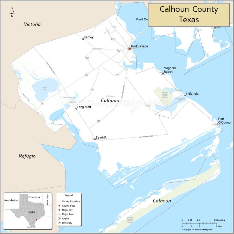
About Calhoun County Map, Texas: The map showing the county boundary, county seat, major cities, highways, water bodies and neighbouring counties.
Related Texas Maps
Map of Calhoun County, Texas
Calhoun County is a county located in the U.S. state of Texas. It's county seat is Port Lavaca. As per 2020 census, the population of Calhoun County is 19727 people and population density is square miles. According to the United States Census Bureau, the county has a total area of 512 sq mi (1,326 km2). Calhoun County was established on 1846.
Facts about Calhoun County, Texas
| Country | United States |
| State | Texas |
| Region | Texas Gulf Coast |
| County Seat | Port Lavaca |
| Named After | John C. Calhoun |
| Established | 1846 |
| Organized | 1846 |
| Coordinates | 28.4180° N, 96.6160° W |
| Total Area | 1,032 sq mi |
| Land Area | 509 sq mi |
| Water Area | 523 sq mi |
| Population (2020) | 20,106 |
| Population Rank | Small coastal county |
| Major City | Port Lavaca |
| Main Industries | Petrochemicals, Shipping, Commercial Fishing, Tourism |
| Major Airport | Calhoun County Airport |
| Time Zone | Central Time (UTC−06:00) |
| Known For | Matagorda Bay, Point Comfort, Fishing and coastal recreation |
| Website | https://www.calhouncotx.org |
Top Attractions in Calhoun County, Texas
- Port Lavaca Bayfront – Relaxing waterfront with piers and coastal views.
- Indianola Historic Site – Ruins and markers from the once-thriving coastal port town.
- Lighthouse Beach – Calm beach with a birding tower and boardwalk.
- Half Moon Reef Lighthouse (Replica) – Iconic local landmark honoring maritime history.
- Calhoun County Museum – Exhibits on regional history, storms, and early settlers.
- Birding Trails of Mad Island Marsh – Popular wildlife spot for coastal birdwatching.
- Fishing Piers of Port Lavaca – Well-known spots for fishing on Lavaca Bay.
- Magnolia Beach – RV-friendly hard-packed shell beach with calm waters.
- Port O’Connor – Gateway to fishing, boating, and the Matagorda Island area.
- Matagorda Island Wildlife Management Area – Remote barrier island with pristine natural scenery.
Cities and Towns in Calhoun County, Texas
| Place | Type | Population (Census 2020) | Latitude & Longitude |
|---|---|---|---|
| Port Lavaca (county seat) | City | 11340 | 28.6158°N, 96.6261°W |
| Point Comfort | City | 737 | 28.6808°N, 96.5605°W |
| Seadrift | City | 1364 | 28.4108°N, 96.7122°W |
| Port O'Connor | Census Designated Place (CDP) | 1181 | 28.4453°N, 96.4047°W |
| Magnolia Beach | Unincorporated Community | N/A | 28.5586°N, 96.5427°W |
| Long Mott | Unincorporated Community | N/A | 28.6672°N, 96.7703°W |
| Olivia | Unincorporated Community | N/A | 28.5864°N, 96.5986°W |
| Indianola | Unincorporated Community | N/A | 28.5139°N, 96.4944°W |
What are Major Roads and Highways in Calhoun County
Major highways connect the county to nearby regions and cities.
- State Highway 35 - northeast toward Port Lavaca and southwest toward Rockport
- State Highway 185 - northwest toward Victoria and southeast toward Port O'Connor
- State Highway 238 - connects Port Lavaca with Interstate corridors near Victoria
- Farm to Market Road 1090 - serves coastal communities near Port O'Connor
- Farm to Market Road 1289 - connects Seadrift with inland portions of the county
- Farm to Market Road 2717 - serves Magnolia Beach and surrounding coastal areas
What are Neighboring Counties of Calhoun County
- Jackson County (north)
- Victoria County (northwest)
- Refugio County (southwest)
- Aransas County (southwest across San Antonio Bay)
Distance from Calhoun County to Nearby Cities
The following distances are measured by road (driving).
- Port Lavaca to Point Comfort (Calhoun County), Texas - 4 mi (6 km)
- Port Lavaca to Seadrift (Calhoun County), Texas - 25 mi (40 km)
- Port Lavaca to Port O'Connor (Calhoun County), Texas - 29 mi (47 km)
- Port Lavaca to Victoria (Victoria County), Texas - 30 mi (48 km)
- Port Lavaca to Edna (Jackson County), Texas - 27 mi (43 km)
- Port Lavaca to Port Lavaca Industrial Complex Area (Calhoun County), Texas - 7 mi (11 km)
- Port Lavaca to Refugio (Refugio County), Texas - 48 mi (77 km)
- Port Lavaca to Rockport (Aransas County), Texas - 61 mi (98 km)
- Port Lavaca to Cuero (DeWitt County), Texas - 58 mi (93 km)
- Port Lavaca to Bay City (Matagorda County), Texas - 69 mi (111 km)
- Port Lavaca to Corpus Christi (Nueces County), Texas - 95 mi (153 km)
- Port Lavaca to Wharton (Wharton County), Texas - 84 mi (135 km)
- Port Lavaca to Houston (Harris County), Texas - 128 mi (206 km)
- Port Lavaca to San Antonio (Bexar County), Texas - 145 mi (233 km)
- Port Lavaca to Austin (Travis County), Texas - 143 mi (230 km)
Waterbodies in Calhoun County
Matagorda Bay, Lavaca Bay, Espiritu Santo Bay, San Antonio Bay, Gulf of Mexico, Chocolate Bay, Cox Bay, Keller Bay, Powderhorn Lake, Carancahua Bay, Lavaca River, Guadalupe River estuary, Intracoastal Waterway, Indianola shoreline wetlands, coastal marshes, tidal flats, lagoons, estuaries, and saltwater inlets
Best Golf Courses in Calhoun County, Texas
| Golf Course | Location | Latitude & Longitude |
|---|---|---|
| The Club at Colony Creek | Victoria (serving Calhoun County area) | 28.8537°N, 97.0021°W |
| Riverside Golf Course | Victoria (serving Calhoun County area) | 28.7996°N, 97.0095°W |
Colleges and Universities in Calhoun County, Texas
| Institution Name | Type | Level | Notable For |
|---|---|---|---|
| University of Houston-Victoria at Katy and Victoria Service Area | Public | University | Regional higher education opportunities |
| Victoria College | Public | Community College | Community college district serving Calhoun County |
| Texas A&M AgriLife Extension Service - Calhoun County | Public | University | Agricultural and community education programs |
References
- U.S. Census Bureau - Calhoun County QuickFacts
- Official Calhoun County Website
- Texas State Historical Association - Calhoun County
- Victoria College
- U.S. Geological Survey (GNIS)
- Anderson County Map
- Andrews County Map
- Angelina County Map
- Aransas County Map
- Archer County Map
- Armstrong County Map
- Atascosa County Map
- Austin County Map
- Bailey County Map
- Bandera County Map
- Bastrop County Map
- Baylor County Map
- Bee County Map
- Bell County Map
- Bexar County Map
- Blanco County Map
- Borden County Map
- Bosque County Map
- Bowie County Map
- Brazoria County Map
- Brazos County Map
- Brewster County Map
- Briscoe County Map
- Brooks County Map
- Brown County Map
- Burleson County Map
- Burnet County Map
- Caldwell County Map
- Calhoun County Map
- Callahan County Map
- Cameron County Map
- Camp County Map
- Carson County Map
- Cass County Map
- Castro County Map
- Chambers County Map
- Cherokee County Map
- Childress County Map
- Clay County Map
- Cochran County Map
- Coke County Map
- Coleman County Map
- Collin County Map
- Collingsworth County Map
- Colorado County Map
- Comal County Map
- Comanche County Map
- Concho County Map
- Cooke County Map
- Coryell County Map
- Cottle County Map
- Crane County Map
- Crockett County Map
- Crosby County Map
- Culberson County Map
- Dallam County Map
- Dallas County Map
- Dawson County Map
- Deaf Smith County Map
- Delta County Map
- Denton County Map
- DeWitt County Map
- Dickens County Map
- Dimmit County Map
- Donley County Map
- Duval County Map
- Eastland County Map
- Ector County Map
- Edwards County Map
- Ellis County Map
- El Paso County Map
- Erath County Map
- Falls County Map
- Fannin County Map
- Fayette County Map
- Fisher County Map
- Floyd County Map
- Foard County Map
- Fort Bend County Map
- Franklin County Map
- Freestone County Map
- Frio County Map
- Gaines County Map
- Galveston County Map
- Garza County Map
- Gillespie County Map
- Glasscock County Map
- Goliad County Map
- Gonzales County Map
- Gray County Map
- Grayson County Map
- Gregg County Map
- Grimes County Map
- Guadalupe County Map
- Hale County Map
- Hall County Map
- Hamilton County Map
- Hansford County Map
- Hardeman County Map
- Hardin County Map
- Harris County Map
- Harrison County Map
- Hartley County Map
- Haskell County Map
- Hays County Map
- Hemphill County Map
- Henderson County Map
- Hidalgo County Map
- Hill County Map
- Hockley County Map
- Hood County Map
- Hopkins County Map
- Houston County Map
- Howard County Map
- Hudspeth County Map
- Hunt County Map
- Hutchinson County Map
- Irion County Map
- Jack County Map
- Jackson County Map
- Jasper County Map
- Jeff Davis County Map
- Jefferson County Map
- Jim Hogg County Map
- Jim Wells County Map
- Johnson County Map
- Jones County Map
- Karnes County Map
- Kaufman County Map
- Kendall County Map
- Kenedy County Map
- Kent County Map
- Kerr County Map
- Kimble County Map
- King County Map
- Kinney County Map
- Kleberg County Map
- Knox County Map
- Lamar County Map
- Lamb County Map
- Lampasas County Map
- La Salle County Map
- Lavaca County Map
- Lee County Map
- Leon County Map
- Liberty County Map
- Limestone County Map
- Lipscomb County Map
- Live Oak County Map
- Llano County Map
- Loving County Map
- Lubbock County Map
- Lynn County Map
- McCulloch County Map
- McLennan County Map
- McMullen County Map
- Madison County Map
- Marion County Map
- Martin County Map
- Mason County Map
- Matagorda County Map
- Maverick County Map
- Medina County Map
- Menard County Map
- Midland County Map
- Milam County Map
- Mills County Map
- Mitchell County Map
- Montague County Map
- Montgomery County Map
- Moore County Map
- Morris County Map
- Motley County Map
- Nacogdoches County Map
- Navarro County Map
- Newton County Map
- Nolan County Map
- Nueces County Map
- Ochiltree County Map
- Oldham County Map
- Orange County Map
- Palo Pinto County Map
- Panola County Map
- Parker County Map
- Parmer County Map
- Pecos County Map
- Polk County Map
- Potter County Map
- Presidio County Map
- Rains County Map
- Randall County Map
- Reagan County Map
- Real County Map
- Red River County Map
- Reeves County Map
- Refugio County Map
- Roberts County Map
- Robertson County Map
- Rockwall County Map
- Runnels County Map
- Rusk County Map
- Sabine County Map
- San Augustine County Map
- San Jacinto County Map
- San Patricio County Map
- San Saba County Map
- Schleicher County Map
- Scurry County Map
- Shackelford County Map
- Shelby County Map
- Sherman County Map
- Smith County Map
- Somervell County Map
- Starr County Map
- Stephens County Map
- Sterling County Map
- Stonewall County Map
- Sutton County Map
- Swisher County Map
- Tarrant County Map
- Taylor County Map
- Terrell County Map
- Terry County Map
- Throckmorton County Map
- Titus County Map
- Tom Green County Map
- Travis County Map
- Trinity County Map
- Tyler County Map
- Upshur County Map
- Upton County Map
- Uvalde County Map
- Val Verde County Map
- Van Zandt County Map
- Victoria County Map
- Walker County Map
- Waller County Map
- Ward County Map
- Washington County Map
- Webb County Map
- Wharton County Map
- Wheeler County Map
- Wichita County Map
- Wilbarger County Map
- Willacy County Map
- Williamson County Map
- Wilson County Map
- Winkler County Map
- Wise County Map
- Wood County Map
- Yoakum County Map
- Young County Map
- Zapata County Map
- Zavala County Map
- Alabama Counties
- Alaska boroughs
- Arizona Counties
- Arkansas Counties
- California County Map
- Colorado Counties
- Connecticut Counties
- Delaware Counties
- Florida County Map
- Georgia County Map
- Hawaii Counties
- Idaho Counties
- Illinois Counties
- Indiana Counties
- Iowa Counties
- Kansas Counties
- Kentucky Counties
- Louisiana Counties
- Maine Counties
- Maryland Counties
- Massachusetts Counties
- Michigan County Map
- Minnesota Counties
- Mississippi Counties
- Missouri Counties
- Montana Counties
- Nebraska Counties
- Nevada Counties
- New York Counties
- New Hampshire Counties
- New Jersey Counties
- New Mexico Counties
- North Carolina Counties
- North Dakota Counties
- Ohio County Map
- Oklahoma Counties
- Oregon Counties
- Pennsylvania Counties
- Rhode Island Counties
- South Carolina Counties
- South Dakota Counties
- Map of Tennessee
- Texas County Map
- Utah Counties
- Vermont Counties
- Virginia Counties
- Washington Counties
- West Virginia Counties
- Wisconsin Counties
- Wyoming Counties
References
- ^ QuickFacts: Calhoun County, Texas - United States Census Bureau
- ^ United States Census Bureau - Population and Housing Data
- ^ TIGER/Line Shapefiles - United States Census Bureau
- ^ United States Geological Survey (USGS)
- ^ National Geodetic Survey (NGS), NOAA
- ^ Official Website of Calhoun County, Texas
- ^ Texas Department of Transportation (TxDOT)