Map of Collin County - Collin County is a county located in the U.S. state of Texas. Collin County Map showing cities, highways, important places and water bodies. Get Where is Collin County located in the map, major cities in Collin county, population, areas, and places of interest.
Map of Collin County, Texas
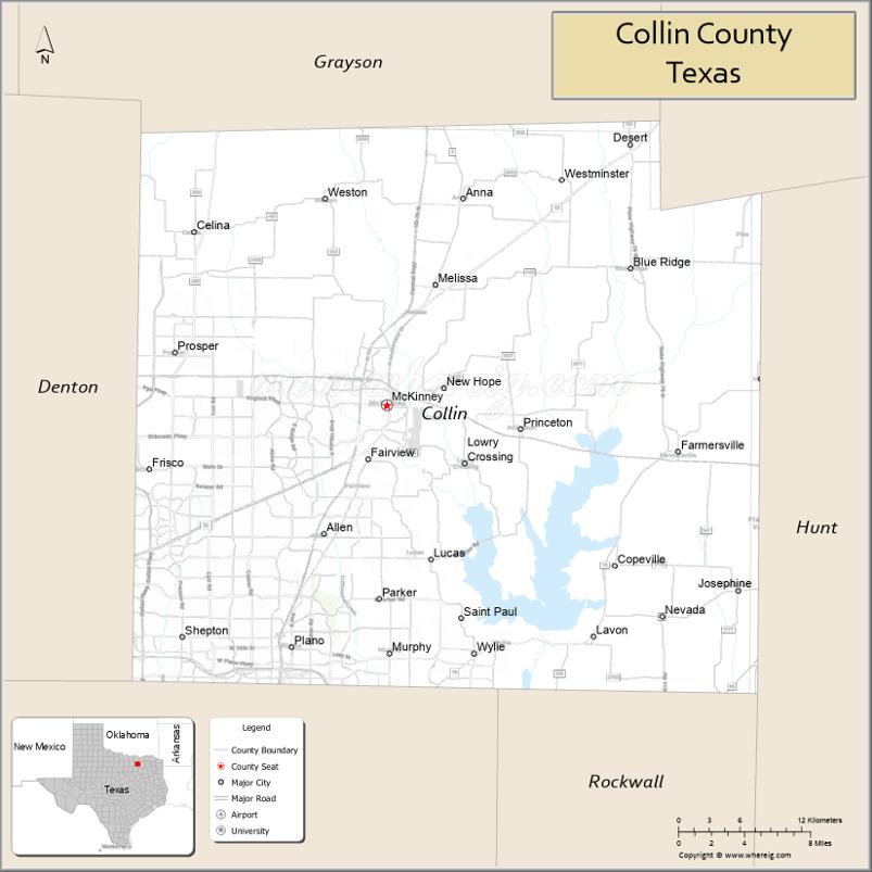
About Collin County Map, Texas: The map showing the county boundary, county seat, major cities, highways, water bodies and neighbouring counties.
Related Texas Maps
Map of Collin County, Texas
Collin County is a county located in the U.S. state of Texas. It's county seat is McKinney. As per 2020 census, the population of Collin County is 1109462 people and population density is square miles. According to the United States Census Bureau, the county has a total area of 848 sq mi (2,196 km2). Collin County was established on 1846.
Facts about Collin County, Texas
| Country | United States |
| State | Texas |
| Region | North Texas / Dallas–Fort Worth Metroplex |
| County Seat | McKinney |
| Named After | Collin McKinney, signer of the Texas Declaration of Independence |
| Established | 1846 |
| Organized | 1846 |
| Coordinates | 33.1790° N, 96.4920° W |
| Total Area | 886 sq mi |
| Land Area | 841 sq mi |
| Water Area | 45 sq mi |
| Population (2020) | 1,064,465 |
| Population Rank | One of the fastest-growing and most populous counties in Texas |
| Major Cities | Plano, McKinney, Frisco, Allen, Wylie |
| Main Industries | Technology, Finance, Healthcare, Education, Corporate Headquarters |
| Major Airport | Dallas/Fort Worth International Airport (nearby) |
| Time Zone | Central Time (UTC−06:00) |
| Known For | Economy & tech boom, top-ranked schools, rapid suburban growth, major corporate campuses |
| Website | https://www.collincountytx.gov |
Top Attractions in Collin County, Texas
- Historic Downtown McKinney – Boutiques, restaurants, galleries, and vibrant town square.
- Heard Natural Science Museum & Wildlife Sanctuary – Nature trails, wildlife exhibits, and seasonal events.
- Allen Premium Outlets – Popular outdoor shopping center with major brands.
- Shops at Legacy (Plano) – Dining, shopping, hotels, and nightlife.
- Arbor Hills Nature Preserve – Scenic hiking and biking trails.
- Plano Heritage Farmstead Museum – Living history farm with 19th-century exhibits.
- Topgolf Allen – Entertainment venue for golf games and social events.
- Southfork Ranch (Parker) – TV-famous “Dallas” ranch offering tours and events.
- Oak Point Park & Nature Preserve – Large natural area with trails and water recreation.
- Collin County History Museum – Local exhibits explaining the region’s heritage.
Cities and Towns in Collin County, Texas
| Place | Type | Population (Census 2020) | Latitude & Longitude |
|---|---|---|---|
| McKinney (county seat) | City | 195308 | 33.1976°N, 96.6153°W |
| Plano | City | 285494 | 33.0198°N, 96.6989°W |
| Frisco | City | 200509 | 33.1507°N, 96.8236°W |
| Allen | City | 104627 | 33.1032°N, 96.6706°W |
| Prosper | Town | 30574 | 33.2362°N, 96.8011°W |
| Celina | City | 16639 | 33.3246°N, 96.7850°W |
| Anna | City | 16689 | 33.3490°N, 96.5486°W |
| Melissa | City | 13817 | 33.2859°N, 96.5722°W |
| Princeton | City | 17627 | 33.1801°N, 96.4980°W |
| Farmersville | City | 3301 | 33.1637°N, 96.3597°W |
| Murphy | City | 21480 | 33.0151°N, 96.6130°W |
| Parker | City | 5370 | 33.0848°N, 96.6169°W |
| Lucas | City | 7298 | 33.0846°N, 96.5853°W |
| Fairview | Town | 10989 | 33.1393°N, 96.6089°W |
| Blue Ridge | City | 1431 | 33.2984°N, 96.4014°W |
| Josephine (partly in Hunt County) | City | 2812 | 33.0618°N, 96.3078°W |
| Nevada | City | 1298 | 33.0582°N, 96.3855°W |
| Lavon | City | 4418 | 33.0271°N, 96.4386°W |
| Lowry Crossing | City | 1841 | 33.1545°N, 96.5483°W |
| Weston | City | 283 | 33.3504°N, 96.6650°W |
| New Hope | City | 632 | 33.2046°N, 96.5680°W |
| Westminster | City | 33.3568°N, 96.4561°W | |
| St. Paul | Town | 33.0432°N, 96.5508°W |
What are Major Roads and Highways in Collin County
Major highways connect the county to nearby regions and cities.
- U.S. Highway 75 (Central Expressway) - north toward Sherman and south toward Dallas
- U.S. Highway 380 - east-west route connecting McKinney, Princeton, and Prosper
- Dallas North Tollway - connects Frisco, Plano, and Dallas
- President George Bush Turnpike - serves southern Collin County communities
- State Highway 121 (Sam Rayburn Tollway) - connects Plano, Allen, McKinney, and DFW Airport area
- State Highway 5 - parallel route through McKinney, Anna, and Melissa
- State Highway 289 (Preston Road) - north-south route through Frisco and Prosper
- State Highway 78 - connects Farmersville, Lavon, and Garland
- State Highway 205 - serves southeastern Collin County communities
What are Neighboring Counties of Collin County
- Grayson County (north)
- Fannin County (northeast)
- Hunt County (east)
- Rockwall County (southeast)
- Dallas County (south)
- Denton County (west)
Distance from Collin County to Nearby Cities
The following distances are measured by road (driving).
- McKinney to Allen (Collin County), Texas - 8 mi (13 km)
- McKinney to Frisco (Collin County), Texas - 14 mi (23 km)
- McKinney to Plano (Collin County), Texas - 17 mi (27 km)
- McKinney to Princeton (Collin County), Texas - 10 mi (16 km)
- McKinney to Anna (Collin County), Texas - 11 mi (18 km)
- McKinney to Melissa (Collin County), Texas - 6 mi (10 km)
- McKinney to Prosper (Collin County), Texas - 13 mi (21 km)
- McKinney to Farmersville (Collin County), Texas - 18 mi (29 km)
- McKinney to Sherman (Grayson County), Texas - 31 mi (50 km)
- McKinney to Denton (Denton County), Texas - 32 mi (51 km)
- McKinney to Greenville (Hunt County), Texas - 35 mi (56 km)
- McKinney to Rockwall (Rockwall County), Texas - 29 mi (47 km)
- McKinney to Dallas (Dallas County), Texas - 33 mi (53 km)
- McKinney to Fort Worth (Tarrant County), Texas - 61 mi (98 km)
- McKinney to Denton (Denton County), Texas - 32 mi (51 km)
Waterbodies in Collin County
Lavon Lake, Lake Ray Hubbard, Lewisville Lake shoreline, East Fork Trinity River, Sister Grove Creek, Wilson Creek, Rowlett Creek, Pilot Grove Creek, Honey Creek, White Rock Creek tributaries, Lavon Reservoir, Trinity River watershed, wetlands, flood-control lakes, ponds, and seasonal streams
Best Golf Courses in Collin County, Texas
| Golf Course | Location | Latitude & Longitude |
|---|---|---|
| TPC Craig Ranch | McKinney | 33.1723°N, 96.7198°W |
| Stonebridge Ranch Country Club - Dye Course | McKinney | 33.1876°N, 96.6714°W |
| Stonebridge Ranch Country Club - Hills Course | McKinney | 33.1948°N, 96.6807°W |
| Oak Hollow Golf Course | McKinney | 33.2041°N, 96.6362°W |
| Heritage Ranch Golf & Country Club | Fairview | 33.1477°N, 96.6118°W |
| The Courses at Watters Creek | Plano | 33.0926°N, 96.6765°W |
| Gleneagles Country Club - Kings Course | Plano | 33.0637°N, 96.8176°W |
| Gleneagles Country Club - Queens Course | Plano | 33.0629°N, 96.8168°W |
| The Clubs of Stonebridge Ranch | McKinney | 33.1892°N, 96.6738°W |
| Plantation Golf Club | Frisco | 33.1375°N, 96.8393°W |
| Frisco Lakes Golf Club | Frisco | 33.1834°N, 96.9242°W |
| The Trails of Frisco Golf Club | Frisco | 33.1287°N, 96.8548°W |
| Twin Creeks Golf Club | Allen | 33.1048°N, 96.7115°W |
| Hurricane Creek Country Club | Anna | 33.3541°N, 96.5637°W |
Colleges and Universities in Collin County, Texas
| Institution Name | Type | Level | Notable For |
|---|---|---|---|
| Collin College | Public | Community College | Large multi-campus community college district |
| University of North Texas at Frisco | Public | University | Undergraduate and graduate degree programs |
| University of Texas at Dallas | Public | University | Major research university serving the region |
| Parker University | Private | University | Health sciences and chiropractic education |
| National University - North Texas Campus | Private | University | Adult and professional degree programs |
References
- U.S. Census Bureau - Collin County QuickFacts
- Official Collin County Website
- Texas State Historical Association - Collin County
- Collin College
- University of North Texas at Frisco
- Anderson County Map
- Andrews County Map
- Angelina County Map
- Aransas County Map
- Archer County Map
- Armstrong County Map
- Atascosa County Map
- Austin County Map
- Bailey County Map
- Bandera County Map
- Bastrop County Map
- Baylor County Map
- Bee County Map
- Bell County Map
- Bexar County Map
- Blanco County Map
- Borden County Map
- Bosque County Map
- Bowie County Map
- Brazoria County Map
- Brazos County Map
- Brewster County Map
- Briscoe County Map
- Brooks County Map
- Brown County Map
- Burleson County Map
- Burnet County Map
- Caldwell County Map
- Calhoun County Map
- Callahan County Map
- Cameron County Map
- Camp County Map
- Carson County Map
- Cass County Map
- Castro County Map
- Chambers County Map
- Cherokee County Map
- Childress County Map
- Clay County Map
- Cochran County Map
- Coke County Map
- Coleman County Map
- Collin County Map
- Collingsworth County Map
- Colorado County Map
- Comal County Map
- Comanche County Map
- Concho County Map
- Cooke County Map
- Coryell County Map
- Cottle County Map
- Crane County Map
- Crockett County Map
- Crosby County Map
- Culberson County Map
- Dallam County Map
- Dallas County Map
- Dawson County Map
- Deaf Smith County Map
- Delta County Map
- Denton County Map
- DeWitt County Map
- Dickens County Map
- Dimmit County Map
- Donley County Map
- Duval County Map
- Eastland County Map
- Ector County Map
- Edwards County Map
- Ellis County Map
- El Paso County Map
- Erath County Map
- Falls County Map
- Fannin County Map
- Fayette County Map
- Fisher County Map
- Floyd County Map
- Foard County Map
- Fort Bend County Map
- Franklin County Map
- Freestone County Map
- Frio County Map
- Gaines County Map
- Galveston County Map
- Garza County Map
- Gillespie County Map
- Glasscock County Map
- Goliad County Map
- Gonzales County Map
- Gray County Map
- Grayson County Map
- Gregg County Map
- Grimes County Map
- Guadalupe County Map
- Hale County Map
- Hall County Map
- Hamilton County Map
- Hansford County Map
- Hardeman County Map
- Hardin County Map
- Harris County Map
- Harrison County Map
- Hartley County Map
- Haskell County Map
- Hays County Map
- Hemphill County Map
- Henderson County Map
- Hidalgo County Map
- Hill County Map
- Hockley County Map
- Hood County Map
- Hopkins County Map
- Houston County Map
- Howard County Map
- Hudspeth County Map
- Hunt County Map
- Hutchinson County Map
- Irion County Map
- Jack County Map
- Jackson County Map
- Jasper County Map
- Jeff Davis County Map
- Jefferson County Map
- Jim Hogg County Map
- Jim Wells County Map
- Johnson County Map
- Jones County Map
- Karnes County Map
- Kaufman County Map
- Kendall County Map
- Kenedy County Map
- Kent County Map
- Kerr County Map
- Kimble County Map
- King County Map
- Kinney County Map
- Kleberg County Map
- Knox County Map
- Lamar County Map
- Lamb County Map
- Lampasas County Map
- La Salle County Map
- Lavaca County Map
- Lee County Map
- Leon County Map
- Liberty County Map
- Limestone County Map
- Lipscomb County Map
- Live Oak County Map
- Llano County Map
- Loving County Map
- Lubbock County Map
- Lynn County Map
- McCulloch County Map
- McLennan County Map
- McMullen County Map
- Madison County Map
- Marion County Map
- Martin County Map
- Mason County Map
- Matagorda County Map
- Maverick County Map
- Medina County Map
- Menard County Map
- Midland County Map
- Milam County Map
- Mills County Map
- Mitchell County Map
- Montague County Map
- Montgomery County Map
- Moore County Map
- Morris County Map
- Motley County Map
- Nacogdoches County Map
- Navarro County Map
- Newton County Map
- Nolan County Map
- Nueces County Map
- Ochiltree County Map
- Oldham County Map
- Orange County Map
- Palo Pinto County Map
- Panola County Map
- Parker County Map
- Parmer County Map
- Pecos County Map
- Polk County Map
- Potter County Map
- Presidio County Map
- Rains County Map
- Randall County Map
- Reagan County Map
- Real County Map
- Red River County Map
- Reeves County Map
- Refugio County Map
- Roberts County Map
- Robertson County Map
- Rockwall County Map
- Runnels County Map
- Rusk County Map
- Sabine County Map
- San Augustine County Map
- San Jacinto County Map
- San Patricio County Map
- San Saba County Map
- Schleicher County Map
- Scurry County Map
- Shackelford County Map
- Shelby County Map
- Sherman County Map
- Smith County Map
- Somervell County Map
- Starr County Map
- Stephens County Map
- Sterling County Map
- Stonewall County Map
- Sutton County Map
- Swisher County Map
- Tarrant County Map
- Taylor County Map
- Terrell County Map
- Terry County Map
- Throckmorton County Map
- Titus County Map
- Tom Green County Map
- Travis County Map
- Trinity County Map
- Tyler County Map
- Upshur County Map
- Upton County Map
- Uvalde County Map
- Val Verde County Map
- Van Zandt County Map
- Victoria County Map
- Walker County Map
- Waller County Map
- Ward County Map
- Washington County Map
- Webb County Map
- Wharton County Map
- Wheeler County Map
- Wichita County Map
- Wilbarger County Map
- Willacy County Map
- Williamson County Map
- Wilson County Map
- Winkler County Map
- Wise County Map
- Wood County Map
- Yoakum County Map
- Young County Map
- Zapata County Map
- Zavala County Map
- Alabama Counties
- Alaska boroughs
- Arizona Counties
- Arkansas Counties
- California County Map
- Colorado Counties
- Connecticut Counties
- Delaware Counties
- Florida County Map
- Georgia County Map
- Hawaii Counties
- Idaho Counties
- Illinois Counties
- Indiana Counties
- Iowa Counties
- Kansas Counties
- Kentucky Counties
- Louisiana Counties
- Maine Counties
- Maryland Counties
- Massachusetts Counties
- Michigan County Map
- Minnesota Counties
- Mississippi Counties
- Missouri Counties
- Montana Counties
- Nebraska Counties
- Nevada Counties
- New York Counties
- New Hampshire Counties
- New Jersey Counties
- New Mexico Counties
- North Carolina Counties
- North Dakota Counties
- Ohio County Map
- Oklahoma Counties
- Oregon Counties
- Pennsylvania Counties
- Rhode Island Counties
- South Carolina Counties
- South Dakota Counties
- Map of Tennessee
- Texas County Map
- Utah Counties
- Vermont Counties
- Virginia Counties
- Washington Counties
- West Virginia Counties
- Wisconsin Counties
- Wyoming Counties
References
- ^ QuickFacts: Collin County, Texas - United States Census Bureau
- ^ United States Census Bureau - Population and Housing Data
- ^ TIGER/Line Shapefiles - United States Census Bureau
- ^ United States Geological Survey (USGS)
- ^ National Geodetic Survey (NGS), NOAA
- ^ Official Website of Collin County, Texas
- ^ Texas Department of Transportation (TxDOT)