Map of Waller County - Waller County is a county located in the U.S. state of Texas. Waller County Map showing cities, highways, important places and water bodies. Get Where is Waller County located in the map, major cities in Waller county, population, areas, and places of interest.
Map of Waller County, Texas
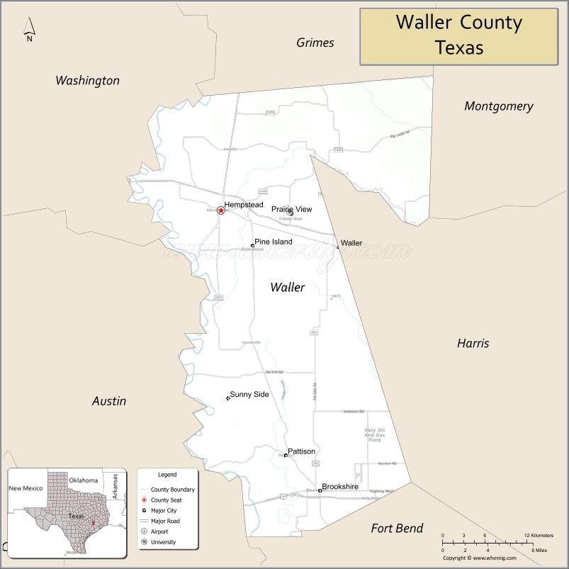
About Waller County Map, Texas: The map showing the county boundary, county seat, major cities, highways, water bodies and neighbouring counties.
Related Texas Maps
Map of Waller County, Texas
Waller County is a county located in the U.S. state of Texas. It's county seat is Hempstead. As per 2020 census, the population of Waller County is 59781 people and population density is square miles. According to the United States Census Bureau, the county has a total area of 514 sq mi (1,331 km2). Waller County was established on 1873.
Facts about Waller County, Texas
| Country | United States |
| State | Texas |
| Region | Southeast Texas |
| County Seat | Hempstead |
| Named After | Edwin Waller, signer of the Texas Declaration of Independence and planner of Austin |
| Established | 1873 |
| Organized | 1873 |
| Coordinates | 29.9520° N, 96.0560° W |
| Total Area | 514 sq mi |
| Land Area | 513 sq mi |
| Water Area | 1 sq mi |
| Population (2020) | 56,794 |
| Population Rank | Mid-sized county in Southeast Texas |
| Major City | Hempstead |
| Main Industries | Agriculture, Education, Manufacturing, Retail |
| Major Airport | Hempstead Municipal Airport (local) |
| Time Zone | Central Time (UTC−06:00) |
| Known For | Prairie View A&M University, Rural countryside, Proximity to Houston |
| Website | https://www.co.waller.tx.us |
Top Attractions in Waller County, Texas
- Prairie View A&M University – Historic HBCU campus and events.
- Waller County Courthouse – Historic courthouse in Hempstead.
- Hempstead Downtown District – Small-town shops and charm.
- Hempstead Railroad Depot – Restored historic rail site.
- Peckerwood Garden Conservation Foundation – Botanical gardens and trails.
- Oil Ranch – Family-friendly agritourism park.
- Hockley Area Parks – Local green spaces and recreation.
- Community Rodeo Events – Seasonal local rodeos.
- Rural Prairie Drives – Scenic countryside views.
- Local Farm & Ranch Areas – Agricultural landscapes and wildlife.
Cities and Towns in Waller County, Texas
| Place | Type | Population (Census 2020) | Latitude & Longitude |
|---|---|---|---|
| Hempstead (county seat) | City | 6732 | 30.0974°N, 96.0783°W |
| Prairie View | City | 6612 | 30.0905°N, 95.9877°W |
| Waller | City | 3602 | 30.0561°N, 95.9269°W |
| Brookshire (partly in Waller County) | City | 5512 | 29.7861°N, 95.9513°W |
| Pine Island | City | 1084 | 30.0999°N, 95.9897°W |
| Katy (partly in Waller County) | City | 21294 | 29.7858°N, 95.8245°W |
| Monaville | Unincorporated Community | N/A | 29.9777°N, 96.0530°W |
| Pattison | Unincorporated Community | N/A | 29.8205°N, 96.0047°W |
| Fields Store | Unincorporated Community | N/A | 30.1002°N, 95.9241°W |
| Howellville | Unincorporated Community | N/A | 29.8097°N, 95.8524°W |
| Hockley (partly in Waller County) | Unincorporated Community | N/A | 30.0266°N, 95.8219°W |
| Sunny Side | Unincorporated Community | N/A | 30.0644°N, 96.1430°W |
What are Major Roads and Highways in Waller County
Major highways connect the county to nearby regions and cities.
- Interstate 10 - east-west corridor connecting Brookshire with Houston and San Antonio
- U.S. Highway 290 - major route linking Hempstead, Waller, Houston, and Austin
- State Highway 6 - connects Hempstead with College Station and Bryan
- State Highway 159 - links Hempstead with Bellville and Fayette County
- Farm to Market Road 1098 - serves northern Waller County communities
- Farm to Market Road 1488 - connects Waller with Magnolia and Montgomery County
- Farm to Market Road 362 - north-south route through central Waller County
- Farm to Market Road 529 - connects eastern Waller County with Houston area communities
What are Neighboring Counties of Waller County
- Grimes County (north)
- Montgomery County (northeast)
- Harris County (east)
- Fort Bend County (south)
- Austin County (southwest)
- Washington County (west)
Distance from Waller County to Nearby Cities
The following distances are measured by road (driving).
- Hempstead to Prairie View (Waller County), Texas - 6 mi (10 km)
- Hempstead to Waller (Waller County), Texas - 15 mi (24 km)
- Hempstead to Brookshire (Waller County), Texas - 21 mi (34 km)
- Hempstead to Bellville (Austin County), Texas - 19 mi (31 km)
- Hempstead to Brenham (Washington County), Texas - 22 mi (35 km)
- Hempstead to Navasota (Grimes County), Texas - 24 mi (39 km)
- Hempstead to Magnolia (Montgomery County), Texas - 30 mi (48 km)
- Hempstead to Katy (Harris County), Texas - 33 mi (53 km)
- Hempstead to Richmond (Fort Bend County), Texas - 39 mi (63 km)
- Hempstead to College Station (Brazos County), Texas - 48 mi (77 km)
- Hempstead to Bryan (Brazos County), Texas - 50 mi (80 km)
- Hempstead to Conroe (Montgomery County), Texas - 50 mi (80 km)
- Hempstead to Houston (Harris County), Texas - 54 mi (87 km)
- Hempstead to Sugar Land (Fort Bend County), Texas - 52 mi (84 km)
- Hempstead to Austin (Travis County), Texas - 108 mi (174 km)
Waterbodies in Waller County
Brazos River, Little Brazos River, Mill Creek, Clear Creek, Walnut Creek, Spring Creek, Cypress Creek, New Year Creek, Bull Creek, Kickapoo Creek, Deer Creek, Cedar Creek, Brazos River Watershed, Gibbons Creek Tributaries
Best Golf Courses in Waller County, Texas
| Golf Course | Location | Latitude & Longitude |
|---|---|---|
| Houston Oaks Golf Course | Hockley | 30.0916°N, 95.8468°W |
| Jubilee Golf Course | Hempstead | 30.1098°N, 96.1024°W |
| Waller County Golf Club | Waller | 30.0698°N, 95.9325°W |
| The Clubs at Houston Oaks | Hockley | 30.0930°N, 95.8448°W |
Colleges and Universities in Waller County, Texas
| Institution Name | Type (Public/Private) | Level | Notable For |
|---|---|---|---|
| Prairie View A&M University | Public | University | Historically Black land-grant university |
| Blinn College - Waller Campus | Public | Community College | Academic transfer and workforce programs |
| Texas A&M Engineering Academy at Blinn-Waller | Public | University | Engineering pathway programs |
| Houston Community College (service area) | Public | Community College | Continuing and workforce education |
| Lone Star College (regional service area) | Public | Community College | Higher education access for county residents |
References
- U.S. Census Bureau QuickFacts - Waller County
- Official Waller County Website
- Prairie View A&M University
- Texas State Historical Association - Waller County
- Waller County, Texas - Communities and Geography
- Anderson County Map
- Andrews County Map
- Angelina County Map
- Aransas County Map
- Archer County Map
- Armstrong County Map
- Atascosa County Map
- Austin County Map
- Bailey County Map
- Bandera County Map
- Bastrop County Map
- Baylor County Map
- Bee County Map
- Bell County Map
- Bexar County Map
- Blanco County Map
- Borden County Map
- Bosque County Map
- Bowie County Map
- Brazoria County Map
- Brazos County Map
- Brewster County Map
- Briscoe County Map
- Brooks County Map
- Brown County Map
- Burleson County Map
- Burnet County Map
- Caldwell County Map
- Calhoun County Map
- Callahan County Map
- Cameron County Map
- Camp County Map
- Carson County Map
- Cass County Map
- Castro County Map
- Chambers County Map
- Cherokee County Map
- Childress County Map
- Clay County Map
- Cochran County Map
- Coke County Map
- Coleman County Map
- Collin County Map
- Collingsworth County Map
- Colorado County Map
- Comal County Map
- Comanche County Map
- Concho County Map
- Cooke County Map
- Coryell County Map
- Cottle County Map
- Crane County Map
- Crockett County Map
- Crosby County Map
- Culberson County Map
- Dallam County Map
- Dallas County Map
- Dawson County Map
- Deaf Smith County Map
- Delta County Map
- Denton County Map
- DeWitt County Map
- Dickens County Map
- Dimmit County Map
- Donley County Map
- Duval County Map
- Eastland County Map
- Ector County Map
- Edwards County Map
- Ellis County Map
- El Paso County Map
- Erath County Map
- Falls County Map
- Fannin County Map
- Fayette County Map
- Fisher County Map
- Floyd County Map
- Foard County Map
- Fort Bend County Map
- Franklin County Map
- Freestone County Map
- Frio County Map
- Gaines County Map
- Galveston County Map
- Garza County Map
- Gillespie County Map
- Glasscock County Map
- Goliad County Map
- Gonzales County Map
- Gray County Map
- Grayson County Map
- Gregg County Map
- Grimes County Map
- Guadalupe County Map
- Hale County Map
- Hall County Map
- Hamilton County Map
- Hansford County Map
- Hardeman County Map
- Hardin County Map
- Harris County Map
- Harrison County Map
- Hartley County Map
- Haskell County Map
- Hays County Map
- Hemphill County Map
- Henderson County Map
- Hidalgo County Map
- Hill County Map
- Hockley County Map
- Hood County Map
- Hopkins County Map
- Houston County Map
- Howard County Map
- Hudspeth County Map
- Hunt County Map
- Hutchinson County Map
- Irion County Map
- Jack County Map
- Jackson County Map
- Jasper County Map
- Jeff Davis County Map
- Jefferson County Map
- Jim Hogg County Map
- Jim Wells County Map
- Johnson County Map
- Jones County Map
- Karnes County Map
- Kaufman County Map
- Kendall County Map
- Kenedy County Map
- Kent County Map
- Kerr County Map
- Kimble County Map
- King County Map
- Kinney County Map
- Kleberg County Map
- Knox County Map
- Lamar County Map
- Lamb County Map
- Lampasas County Map
- La Salle County Map
- Lavaca County Map
- Lee County Map
- Leon County Map
- Liberty County Map
- Limestone County Map
- Lipscomb County Map
- Live Oak County Map
- Llano County Map
- Loving County Map
- Lubbock County Map
- Lynn County Map
- McCulloch County Map
- McLennan County Map
- McMullen County Map
- Madison County Map
- Marion County Map
- Martin County Map
- Mason County Map
- Matagorda County Map
- Maverick County Map
- Medina County Map
- Menard County Map
- Midland County Map
- Milam County Map
- Mills County Map
- Mitchell County Map
- Montague County Map
- Montgomery County Map
- Moore County Map
- Morris County Map
- Motley County Map
- Nacogdoches County Map
- Navarro County Map
- Newton County Map
- Nolan County Map
- Nueces County Map
- Ochiltree County Map
- Oldham County Map
- Orange County Map
- Palo Pinto County Map
- Panola County Map
- Parker County Map
- Parmer County Map
- Pecos County Map
- Polk County Map
- Potter County Map
- Presidio County Map
- Rains County Map
- Randall County Map
- Reagan County Map
- Real County Map
- Red River County Map
- Reeves County Map
- Refugio County Map
- Roberts County Map
- Robertson County Map
- Rockwall County Map
- Runnels County Map
- Rusk County Map
- Sabine County Map
- San Augustine County Map
- San Jacinto County Map
- San Patricio County Map
- San Saba County Map
- Schleicher County Map
- Scurry County Map
- Shackelford County Map
- Shelby County Map
- Sherman County Map
- Smith County Map
- Somervell County Map
- Starr County Map
- Stephens County Map
- Sterling County Map
- Stonewall County Map
- Sutton County Map
- Swisher County Map
- Tarrant County Map
- Taylor County Map
- Terrell County Map
- Terry County Map
- Throckmorton County Map
- Titus County Map
- Tom Green County Map
- Travis County Map
- Trinity County Map
- Tyler County Map
- Upshur County Map
- Upton County Map
- Uvalde County Map
- Val Verde County Map
- Van Zandt County Map
- Victoria County Map
- Walker County Map
- Waller County Map
- Ward County Map
- Washington County Map
- Webb County Map
- Wharton County Map
- Wheeler County Map
- Wichita County Map
- Wilbarger County Map
- Willacy County Map
- Williamson County Map
- Wilson County Map
- Winkler County Map
- Wise County Map
- Wood County Map
- Yoakum County Map
- Young County Map
- Zapata County Map
- Zavala County Map
- Alabama Counties
- Alaska boroughs
- Arizona Counties
- Arkansas Counties
- California County Map
- Colorado Counties
- Connecticut Counties
- Delaware Counties
- Florida County Map
- Georgia County Map
- Hawaii Counties
- Idaho Counties
- Illinois Counties
- Indiana Counties
- Iowa Counties
- Kansas Counties
- Kentucky Counties
- Louisiana Counties
- Maine Counties
- Maryland Counties
- Massachusetts Counties
- Michigan County Map
- Minnesota Counties
- Mississippi Counties
- Missouri Counties
- Montana Counties
- Nebraska Counties
- Nevada Counties
- New York Counties
- New Hampshire Counties
- New Jersey Counties
- New Mexico Counties
- North Carolina Counties
- North Dakota Counties
- Ohio County Map
- Oklahoma Counties
- Oregon Counties
- Pennsylvania Counties
- Rhode Island Counties
- South Carolina Counties
- South Dakota Counties
- Map of Tennessee
- Texas County Map
- Utah Counties
- Vermont Counties
- Virginia Counties
- Washington Counties
- West Virginia Counties
- Wisconsin Counties
- Wyoming Counties
References
- ^ QuickFacts: Waller County, Texas - United States Census Bureau
- ^ United States Census Bureau - Population and Housing Data
- ^ TIGER/Line Shapefiles - United States Census Bureau
- ^ United States Geological Survey (USGS)
- ^ National Geodetic Survey (NGS), NOAA
- ^ Official Website of Waller County, Texas
- ^ Texas Department of Transportation (TxDOT)