Map of Edwards County - Edwards County is a county located in the U.S. state of Texas. Edwards County Map showing cities, highways, important places and water bodies. Get Where is Edwards County located in the map, major cities in Edwards county, population, areas, and places of interest.
Map of Edwards County, Texas
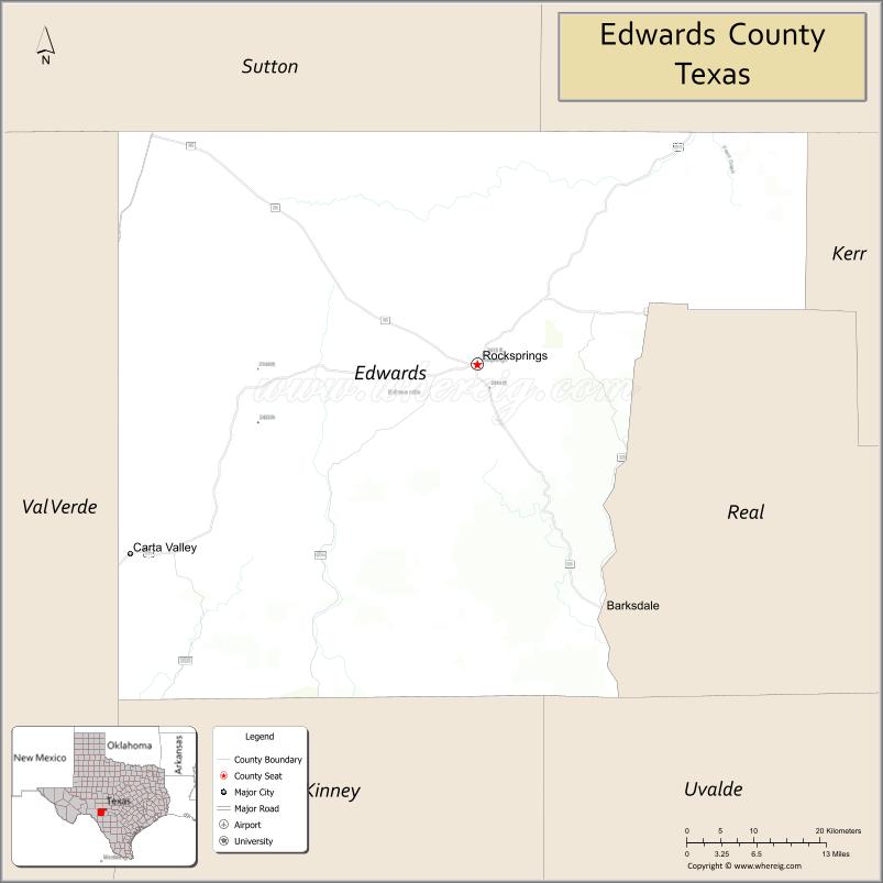
About Edwards County Map, Texas: The map showing the county boundary, county seat, major cities, highways, water bodies and neighbouring counties.
Related Texas Maps
Map of Edwards County, Texas
Edwards County is a county located in the U.S. state of Texas. It's county seat is Rocksprings. As per 2020 census, the population of Edwards County is 1438 people and population density is square miles. According to the United States Census Bureau, the county has a total area of 2,120 sq mi (5,491 km2). Edwards County was established on 1858.
Facts about Edwards County, Texas
| Country | United States |
| State | Texas |
| Region | Southwest Texas / Edwards Plateau |
| County Seat | Rocksprings |
| Named After | Haden Edwards, empresario involved in the Fredonian Rebellion |
| Established | 1858 |
| Organized | 1883 |
| Coordinates | 30.0150° N, 100.3000° W |
| Total Area | 2,120 sq mi |
| Land Area | 2,118 sq mi |
| Water Area | 2 sq mi |
| Population (2020) | 1,422 |
| Population Rank | One of the least populated counties in Texas |
| Major Community | Rocksprings |
| Main Industries | Ranching, Hunting, Tourism (caves & outdoor recreation) |
| Major Airport | Nearest major airport: Kerrville Municipal Airport / Del Rio International Airport |
| Time Zone | Central Time (UTC−06:00) |
| Known For | Devil’s Sinkhole State Natural Area, Limestone canyons, Large game hunting |
| Website | https://www.edwardscountytexas.gov |
Top Attractions in Edwards County, Texas
- Kickapoo Cavern State Park – Cave tours, bat flights, and rugged Hill Country trails.
- Devil’s Sinkhole State Natural Area – Massive vertical cavern famous for bat emergence shows.
- Edwards County Courthouse (Rocksprings) – Historic limestone courthouse on the town square.
- Downtown Rocksprings – Small-town charm with shops, cafés, and local history.
- Angora Goat Warehouse (Historic Site) – Landmark structure tied to the region’s wool and mohair heritage.
- Rocksprings Rodeo Arena – Local events showcasing rodeo traditions.
- Hill Country Ranchlands – Scenic drives with dramatic limestone hills and wildlife.
- Edwards County Park – Community park with shaded areas and picnic spots.
- Nueces River Access Points – Clear water perfect for fishing and outdoor relaxation.
- West Nueces River Canyon – Remote scenic area ideal for photography and nature viewing.
Cities and Towns in Edwards County, Texas
| Place | Type | Population (Census 2020) | Latitude & Longitude |
|---|---|---|---|
| Rocksprings (county seat) | City | 1172 | 30.0152°N, 100.2056°W |
| Barksdale | Unincorporated Community | N/A | 29.7269°N, 100.0859°W |
| Camp Wood (partly in Real County) | City | 689 | 29.6705°N, 100.0106°W |
| Juno | Unincorporated Community | N/A | 30.1738°N, 100.4765°W |
| Kickapoo Springs | Unincorporated Community | N/A | 29.9335°N, 100.4338°W |
| Telegraph | Unincorporated Community | N/A | 30.2938°N, 99.9248°W |
What are Major Roads and Highways in Edwards County
Major highways connect the county to nearby regions and cities.
- U.S. Highway 377 - north toward Junction and south toward Del Rio
- Texas State Highway 55 - connects Rocksprings with Camp Wood and Uvalde County
- Ranch to Market Road 674 - serves ranching communities west of Rocksprings
- Ranch to Market Road 2631 - connects remote ranchlands in northern Edwards County
- Ranch to Market Road 1674 - links agricultural and livestock operations across the county
- County-maintained ranch roads provide access to rural and wildlife management areas
What are Neighboring Counties of Edwards County
- Kimble County (north)
- Kerr County (east)
- Real County (southeast)
- Uvalde County (south)
- Kinney County (southwest)
- Val Verde County (west)
- Sutton County (northwest)
Distance from Edwards County to Nearby Cities
The following distances are measured by road (driving).
- Rocksprings to Camp Wood (Real County), Texas - 32 mi (51 km)
- Rocksprings to Barksdale (Edwards County), Texas - 23 mi (37 km)
- Rocksprings to Junction (Kimble County), Texas - 41 mi (66 km)
- Rocksprings to Sonora (Sutton County), Texas - 47 mi (76 km)
- Rocksprings to Uvalde (Uvalde County), Texas - 69 mi (111 km)
- Rocksprings to Kerrville (Kerr County), Texas - 79 mi (127 km)
- Rocksprings to Del Rio (Val Verde County), Texas - 97 mi (156 km)
- Rocksprings to Leakey (Real County), Texas - 41 mi (66 km)
- Rocksprings to Brackettville (Kinney County), Texas - 73 mi (117 km)
- Rocksprings to San Angelo (Tom Green County), Texas - 120 mi (193 km)
- Rocksprings to Fredericksburg (Gillespie County), Texas - 104 mi (167 km)
- Rocksprings to San Antonio (Bexar County), Texas - 136 mi (219 km)
- Rocksprings to Austin (Travis County), Texas - 164 mi (264 km)
- Rocksprings to Midland (Midland County), Texas - 220 mi (354 km)
- Rocksprings to El Paso (El Paso County), Texas - 465 mi (748 km)
Waterbodies in Edwards County
Nueces River, West Nueces River, Llano River tributaries, Hackberry Creek, Pulliam Creek, Sycamore Creek, Johnson Creek, Dolan Creek, Devil's Sinkhole watershed, springs, limestone aquifer recharge zones, stock ponds, wetlands, seasonal streams, and Edwards Plateau waterways
Best Golf Courses in Edwards County, Texas
| Golf Course | Location | Latitude & Longitude |
|---|---|---|
| Rocksprings Golf Course | Rocksprings | 30.0198°N, 100.2095°W |
Colleges and Universities in Edwards County, Texas
| Institution Name | Type | Level | Notable For |
|---|---|---|---|
| Sul Ross State University | Public | University | Regional public university serving Southwest Texas |
| Southwest Texas Junior College | Public | Community College | Community college serving nearby counties and rural residents |
| Texas Tech University | Public | University | Distance learning and extension programs available to the region |
| Texas A&M AgriLife Extension Service - Edwards County | Public | University | Agricultural and community education programs |
References
- U.S. Census Bureau - Edwards County QuickFacts
- Official Edwards County Website
- Texas State Historical Association - Edwards County
- Texas Parks and Wildlife - Devil's Sinkhole State Natural Area
- Sul Ross State University
- Anderson County Map
- Andrews County Map
- Angelina County Map
- Aransas County Map
- Archer County Map
- Armstrong County Map
- Atascosa County Map
- Austin County Map
- Bailey County Map
- Bandera County Map
- Bastrop County Map
- Baylor County Map
- Bee County Map
- Bell County Map
- Bexar County Map
- Blanco County Map
- Borden County Map
- Bosque County Map
- Bowie County Map
- Brazoria County Map
- Brazos County Map
- Brewster County Map
- Briscoe County Map
- Brooks County Map
- Brown County Map
- Burleson County Map
- Burnet County Map
- Caldwell County Map
- Calhoun County Map
- Callahan County Map
- Cameron County Map
- Camp County Map
- Carson County Map
- Cass County Map
- Castro County Map
- Chambers County Map
- Cherokee County Map
- Childress County Map
- Clay County Map
- Cochran County Map
- Coke County Map
- Coleman County Map
- Collin County Map
- Collingsworth County Map
- Colorado County Map
- Comal County Map
- Comanche County Map
- Concho County Map
- Cooke County Map
- Coryell County Map
- Cottle County Map
- Crane County Map
- Crockett County Map
- Crosby County Map
- Culberson County Map
- Dallam County Map
- Dallas County Map
- Dawson County Map
- Deaf Smith County Map
- Delta County Map
- Denton County Map
- DeWitt County Map
- Dickens County Map
- Dimmit County Map
- Donley County Map
- Duval County Map
- Eastland County Map
- Ector County Map
- Edwards County Map
- Ellis County Map
- El Paso County Map
- Erath County Map
- Falls County Map
- Fannin County Map
- Fayette County Map
- Fisher County Map
- Floyd County Map
- Foard County Map
- Fort Bend County Map
- Franklin County Map
- Freestone County Map
- Frio County Map
- Gaines County Map
- Galveston County Map
- Garza County Map
- Gillespie County Map
- Glasscock County Map
- Goliad County Map
- Gonzales County Map
- Gray County Map
- Grayson County Map
- Gregg County Map
- Grimes County Map
- Guadalupe County Map
- Hale County Map
- Hall County Map
- Hamilton County Map
- Hansford County Map
- Hardeman County Map
- Hardin County Map
- Harris County Map
- Harrison County Map
- Hartley County Map
- Haskell County Map
- Hays County Map
- Hemphill County Map
- Henderson County Map
- Hidalgo County Map
- Hill County Map
- Hockley County Map
- Hood County Map
- Hopkins County Map
- Houston County Map
- Howard County Map
- Hudspeth County Map
- Hunt County Map
- Hutchinson County Map
- Irion County Map
- Jack County Map
- Jackson County Map
- Jasper County Map
- Jeff Davis County Map
- Jefferson County Map
- Jim Hogg County Map
- Jim Wells County Map
- Johnson County Map
- Jones County Map
- Karnes County Map
- Kaufman County Map
- Kendall County Map
- Kenedy County Map
- Kent County Map
- Kerr County Map
- Kimble County Map
- King County Map
- Kinney County Map
- Kleberg County Map
- Knox County Map
- Lamar County Map
- Lamb County Map
- Lampasas County Map
- La Salle County Map
- Lavaca County Map
- Lee County Map
- Leon County Map
- Liberty County Map
- Limestone County Map
- Lipscomb County Map
- Live Oak County Map
- Llano County Map
- Loving County Map
- Lubbock County Map
- Lynn County Map
- McCulloch County Map
- McLennan County Map
- McMullen County Map
- Madison County Map
- Marion County Map
- Martin County Map
- Mason County Map
- Matagorda County Map
- Maverick County Map
- Medina County Map
- Menard County Map
- Midland County Map
- Milam County Map
- Mills County Map
- Mitchell County Map
- Montague County Map
- Montgomery County Map
- Moore County Map
- Morris County Map
- Motley County Map
- Nacogdoches County Map
- Navarro County Map
- Newton County Map
- Nolan County Map
- Nueces County Map
- Ochiltree County Map
- Oldham County Map
- Orange County Map
- Palo Pinto County Map
- Panola County Map
- Parker County Map
- Parmer County Map
- Pecos County Map
- Polk County Map
- Potter County Map
- Presidio County Map
- Rains County Map
- Randall County Map
- Reagan County Map
- Real County Map
- Red River County Map
- Reeves County Map
- Refugio County Map
- Roberts County Map
- Robertson County Map
- Rockwall County Map
- Runnels County Map
- Rusk County Map
- Sabine County Map
- San Augustine County Map
- San Jacinto County Map
- San Patricio County Map
- San Saba County Map
- Schleicher County Map
- Scurry County Map
- Shackelford County Map
- Shelby County Map
- Sherman County Map
- Smith County Map
- Somervell County Map
- Starr County Map
- Stephens County Map
- Sterling County Map
- Stonewall County Map
- Sutton County Map
- Swisher County Map
- Tarrant County Map
- Taylor County Map
- Terrell County Map
- Terry County Map
- Throckmorton County Map
- Titus County Map
- Tom Green County Map
- Travis County Map
- Trinity County Map
- Tyler County Map
- Upshur County Map
- Upton County Map
- Uvalde County Map
- Val Verde County Map
- Van Zandt County Map
- Victoria County Map
- Walker County Map
- Waller County Map
- Ward County Map
- Washington County Map
- Webb County Map
- Wharton County Map
- Wheeler County Map
- Wichita County Map
- Wilbarger County Map
- Willacy County Map
- Williamson County Map
- Wilson County Map
- Winkler County Map
- Wise County Map
- Wood County Map
- Yoakum County Map
- Young County Map
- Zapata County Map
- Zavala County Map
- Alabama Counties
- Alaska boroughs
- Arizona Counties
- Arkansas Counties
- California County Map
- Colorado Counties
- Connecticut Counties
- Delaware Counties
- Florida County Map
- Georgia County Map
- Hawaii Counties
- Idaho Counties
- Illinois Counties
- Indiana Counties
- Iowa Counties
- Kansas Counties
- Kentucky Counties
- Louisiana Counties
- Maine Counties
- Maryland Counties
- Massachusetts Counties
- Michigan County Map
- Minnesota Counties
- Mississippi Counties
- Missouri Counties
- Montana Counties
- Nebraska Counties
- Nevada Counties
- New York Counties
- New Hampshire Counties
- New Jersey Counties
- New Mexico Counties
- North Carolina Counties
- North Dakota Counties
- Ohio County Map
- Oklahoma Counties
- Oregon Counties
- Pennsylvania Counties
- Rhode Island Counties
- South Carolina Counties
- South Dakota Counties
- Map of Tennessee
- Texas County Map
- Utah Counties
- Vermont Counties
- Virginia Counties
- Washington Counties
- West Virginia Counties
- Wisconsin Counties
- Wyoming Counties
References
- ^ QuickFacts: Edwards County, Texas - United States Census Bureau
- ^ United States Census Bureau - Population and Housing Data
- ^ TIGER/Line Shapefiles - United States Census Bureau
- ^ United States Geological Survey (USGS)
- ^ National Geodetic Survey (NGS), NOAA
- ^ Official Website of Edwards County, Texas
- ^ Texas Department of Transportation (TxDOT)