Map of Williamson County - Williamson County is a county located in the U.S. state of Texas. Williamson County Map showing cities, highways, important places and water bodies. Get Where is Williamson County located in the map, major cities in Williamson county, population, areas, and places of interest.
Map of Williamson County, Texas
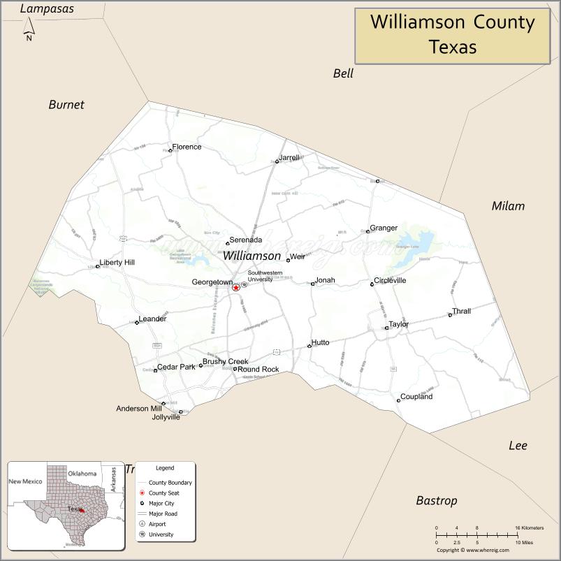
About Williamson County Map, Texas: The map showing the county boundary, county seat, major cities, highways, water bodies and neighbouring counties.
Related Texas Maps
Map of Williamson County, Texas
Williamson County is a county located in the U.S. state of Texas. It's county seat is Georgetown. As per 2020 census, the population of Williamson County is 643026 people and population density is square miles. According to the United States Census Bureau, the county has a total area of 1,124 sq mi (2,911 km2). Williamson County was established on 1848.
Facts about Williamson County, Texas
| Country | United States |
| State | Texas |
| Region | Central Texas |
| County Seat | Georgetown |
| Named After | Robert McAlpin Williamson (“Three-Legged Willie”), Texas judge and politician |
| Established | 1848 |
| Organized | 1848 |
| Coordinates | 30.6490° N, 97.6000° W |
| Total Area | 1,134 sq mi |
| Land Area | 1,118 sq mi |
| Water Area | 16 sq mi |
| Population (2020) | 422,679 |
| Population Rank | One of the fastest-growing counties in Texas |
| Major City | Round Rock |
| Main Industries | Technology, Healthcare, Education, Manufacturing, Retail |
| Major Airport | Austin-Bergstrom International Airport (nearby) |
| Time Zone | Central Time (UTC−06:00) |
| Known For | Rapid suburban growth, Historic Georgetown Square, Tech corridor proximity |
| Website | https://www.wilco.org |
Top Attractions in Williamson County, Texas
- Inner Space Cavern – Underground caves and guided tours.
- Georgetown Historic Downtown Square – Shops, dining, and charm.
- Blue Hole Park – Scenic swimming and trails.
- Lake Georgetown – Hiking, fishing, and boating.
- Williamson County Courthouse – Iconic courthouse landmark.
- Round Rock Express Stadium – Minor league baseball games.
- San Gabriel Park – River trails and green space.
- Old Settlers Park – Sports fields and recreation.
- Berry Springs Park & Preserve – Nature trails and wildlife.
- Downtown Round Rock – Shops, dining, and live music.
Cities and Towns in Williamson County, Texas
| Place | Type | Population (Census 2020) | Latitude & Longitude |
|---|---|---|---|
| Georgetown (county seat) | City | 67576 | 30.6333°N, 97.6770°W |
| Round Rock | City | 119468 | 30.5083°N, 97.6789°W |
| Cedar Park | City | 77595 | 30.5052°N, 97.8203°W |
| Leander | City | 59356 | 30.5788°N, 97.8531°W |
| Taylor | City | 16170 | 30.5708°N, 97.4094°W |
| Hutto | City | 27631 | 30.5427°N, 97.5467°W |
| Liberty Hill | City | 3967 | 30.6649°N, 97.9228°W |
| Jarrell | City | 1760 | 30.8241°N, 97.6047°W |
| Granger | City | 1236 | 30.7177°N, 97.4425°W |
| Florence | City | 1136 | 30.8416°N, 97.7925°W |
| Thrall | City | 816 | 30.5890°N, 97.2968°W |
| Coupland | City | 298 | 30.4560°N, 97.3922°W |
| Brushy Creek | Census Designated Place (CDP) | 22519 | 30.5136°N, 97.7392°W |
| Andice | Unincorporated Community | N/A | 30.7813°N, 97.8508°W |
| Weir | Unincorporated Community | N/A | 30.6660°N, 97.5972°W |
| Walburg | Unincorporated Community | N/A | 30.7210°N, 97.5169°W |
What are Major Roads and Highways in Williamson County
Major highways connect the county to nearby regions and cities.
- Interstate 35 - major north-south corridor connecting Georgetown, Round Rock, Austin, Waco, and Dallas
- U.S. Highway 79 - connects Round Rock, Hutto, Taylor, Rockdale, and East Texas communities
- U.S. Highway 183 - links Leander and Cedar Park with Austin and Lampasas
- State Highway 29 - connects Georgetown with Burnet, Liberty Hill, and Llano
- State Highway 45 Toll - major toll route connecting Williamson County with Travis County
- State Highway 130 Toll - bypass route east of Austin serving Georgetown, Hutto, and Taylor
- Farm to Market Road 1431 - connects Cedar Park, Leander, and western Hill Country communities
- Farm to Market Road 971 - serves eastern Williamson County agricultural areas
What are Neighboring Counties of Williamson County
- Bell County (north)
- Milam County (east)
- Lee County (southeast)
- Bastrop County (south)
- Travis County (southwest)
- Burnet County (west)
Distance from Williamson County to Nearby Cities
The following distances are measured by road (driving).
- Georgetown to Round Rock (Williamson County), Texas - 11 mi (18 km)
- Georgetown to Cedar Park (Williamson County), Texas - 17 mi (27 km)
- Georgetown to Leander (Williamson County), Texas - 15 mi (24 km)
- Georgetown to Hutto (Williamson County), Texas - 16 mi (26 km)
- Georgetown to Taylor (Williamson County), Texas - 19 mi (31 km)
- Georgetown to Liberty Hill (Williamson County), Texas - 13 mi (21 km)
- Georgetown to Jarrell (Williamson County), Texas - 13 mi (21 km)
- Georgetown to Austin (Travis County), Texas - 31 mi (50 km)
- Georgetown to Pflugerville (Travis County), Texas - 20 mi (32 km)
- Georgetown to Cedar Park (Williamson County), Texas - 17 mi (27 km)
- Georgetown to Burnet (Burnet County), Texas - 35 mi (56 km)
- Georgetown to Temple (Bell County), Texas - 37 mi (60 km)
- Georgetown to Bastrop (Bastrop County), Texas - 52 mi (84 km)
- Georgetown to Killeen (Bell County), Texas - 44 mi (71 km)
- Georgetown to Waco (McLennan County), Texas - 67 mi (108 km)
Waterbodies in Williamson County
Lake Georgetown, Granger Lake, San Gabriel River, North San Gabriel River, South San Gabriel River, Brushy Creek, Berry Creek, Chandler Branch, Cowan Creek, Donahoe Creek, Georgetown Lake Dam Reservoir, Lake Creek, Willis Creek, Brazos River Watershed, San Gabriel River Watershed
Best Golf Courses in Williamson County, Texas
| Golf Course | Location | Latitude & Longitude |
|---|---|---|
| Cimarron Hills Golf & Country Club | Georgetown | 30.7041°N, 97.7015°W |
| Berry Creek Country Club | Georgetown | 30.6915°N, 97.6928°W |
| White Wing Golf Club | Georgetown | 30.7184°N, 97.7321°W |
| Cowan Creek Golf Club | Georgetown | 30.7425°N, 97.7818°W |
| Legacy Hills Golf Club | Georgetown | 30.6757°N, 97.7258°W |
| Forest Creek Golf Club | Round Rock | 30.5188°N, 97.5913°W |
| Teravista Golf Club | Round Rock | 30.5579°N, 97.6475°W |
| Star Ranch Golf Club | Hutto | 30.5182°N, 97.5465°W |
| Crystal Falls Golf Club | Leander | 30.6220°N, 97.8896°W |
| Twin Creeks Country Club | Cedar Park | 30.5008°N, 97.8348°W |
| Balcones Country Club | Cedar Park | 30.4708°N, 97.8015°W |
| River Place Country Club | Austin (Williamson County portion nearby) | 30.3793°N, 97.8270°W |
Colleges and Universities in Williamson County, Texas
| Institution Name | Type (Public/Private) | Level | Notable For |
|---|---|---|---|
| Texas State University - Round Rock Campus | Public | University | Health professions and graduate programs |
| Austin Community College - Round Rock Campus | Public | Community College | Transfer, workforce, and technical education |
| Southwestern University | Private | University | Oldest university in Texas |
| Temple College - Taylor Center | Public | Community College | Regional higher education programs |
| Texas A&M Health Science Center - Round Rock | Public | University | Medical and health sciences education |
References
- U.S. Census Bureau QuickFacts - Williamson County
- Williamson County History and Statistics
- Williamson County Municipalities
- Southwestern University
- USGS Geographic Names Information System (GNIS)
- Anderson County Map
- Andrews County Map
- Angelina County Map
- Aransas County Map
- Archer County Map
- Armstrong County Map
- Atascosa County Map
- Austin County Map
- Bailey County Map
- Bandera County Map
- Bastrop County Map
- Baylor County Map
- Bee County Map
- Bell County Map
- Bexar County Map
- Blanco County Map
- Borden County Map
- Bosque County Map
- Bowie County Map
- Brazoria County Map
- Brazos County Map
- Brewster County Map
- Briscoe County Map
- Brooks County Map
- Brown County Map
- Burleson County Map
- Burnet County Map
- Caldwell County Map
- Calhoun County Map
- Callahan County Map
- Cameron County Map
- Camp County Map
- Carson County Map
- Cass County Map
- Castro County Map
- Chambers County Map
- Cherokee County Map
- Childress County Map
- Clay County Map
- Cochran County Map
- Coke County Map
- Coleman County Map
- Collin County Map
- Collingsworth County Map
- Colorado County Map
- Comal County Map
- Comanche County Map
- Concho County Map
- Cooke County Map
- Coryell County Map
- Cottle County Map
- Crane County Map
- Crockett County Map
- Crosby County Map
- Culberson County Map
- Dallam County Map
- Dallas County Map
- Dawson County Map
- Deaf Smith County Map
- Delta County Map
- Denton County Map
- DeWitt County Map
- Dickens County Map
- Dimmit County Map
- Donley County Map
- Duval County Map
- Eastland County Map
- Ector County Map
- Edwards County Map
- Ellis County Map
- El Paso County Map
- Erath County Map
- Falls County Map
- Fannin County Map
- Fayette County Map
- Fisher County Map
- Floyd County Map
- Foard County Map
- Fort Bend County Map
- Franklin County Map
- Freestone County Map
- Frio County Map
- Gaines County Map
- Galveston County Map
- Garza County Map
- Gillespie County Map
- Glasscock County Map
- Goliad County Map
- Gonzales County Map
- Gray County Map
- Grayson County Map
- Gregg County Map
- Grimes County Map
- Guadalupe County Map
- Hale County Map
- Hall County Map
- Hamilton County Map
- Hansford County Map
- Hardeman County Map
- Hardin County Map
- Harris County Map
- Harrison County Map
- Hartley County Map
- Haskell County Map
- Hays County Map
- Hemphill County Map
- Henderson County Map
- Hidalgo County Map
- Hill County Map
- Hockley County Map
- Hood County Map
- Hopkins County Map
- Houston County Map
- Howard County Map
- Hudspeth County Map
- Hunt County Map
- Hutchinson County Map
- Irion County Map
- Jack County Map
- Jackson County Map
- Jasper County Map
- Jeff Davis County Map
- Jefferson County Map
- Jim Hogg County Map
- Jim Wells County Map
- Johnson County Map
- Jones County Map
- Karnes County Map
- Kaufman County Map
- Kendall County Map
- Kenedy County Map
- Kent County Map
- Kerr County Map
- Kimble County Map
- King County Map
- Kinney County Map
- Kleberg County Map
- Knox County Map
- Lamar County Map
- Lamb County Map
- Lampasas County Map
- La Salle County Map
- Lavaca County Map
- Lee County Map
- Leon County Map
- Liberty County Map
- Limestone County Map
- Lipscomb County Map
- Live Oak County Map
- Llano County Map
- Loving County Map
- Lubbock County Map
- Lynn County Map
- McCulloch County Map
- McLennan County Map
- McMullen County Map
- Madison County Map
- Marion County Map
- Martin County Map
- Mason County Map
- Matagorda County Map
- Maverick County Map
- Medina County Map
- Menard County Map
- Midland County Map
- Milam County Map
- Mills County Map
- Mitchell County Map
- Montague County Map
- Montgomery County Map
- Moore County Map
- Morris County Map
- Motley County Map
- Nacogdoches County Map
- Navarro County Map
- Newton County Map
- Nolan County Map
- Nueces County Map
- Ochiltree County Map
- Oldham County Map
- Orange County Map
- Palo Pinto County Map
- Panola County Map
- Parker County Map
- Parmer County Map
- Pecos County Map
- Polk County Map
- Potter County Map
- Presidio County Map
- Rains County Map
- Randall County Map
- Reagan County Map
- Real County Map
- Red River County Map
- Reeves County Map
- Refugio County Map
- Roberts County Map
- Robertson County Map
- Rockwall County Map
- Runnels County Map
- Rusk County Map
- Sabine County Map
- San Augustine County Map
- San Jacinto County Map
- San Patricio County Map
- San Saba County Map
- Schleicher County Map
- Scurry County Map
- Shackelford County Map
- Shelby County Map
- Sherman County Map
- Smith County Map
- Somervell County Map
- Starr County Map
- Stephens County Map
- Sterling County Map
- Stonewall County Map
- Sutton County Map
- Swisher County Map
- Tarrant County Map
- Taylor County Map
- Terrell County Map
- Terry County Map
- Throckmorton County Map
- Titus County Map
- Tom Green County Map
- Travis County Map
- Trinity County Map
- Tyler County Map
- Upshur County Map
- Upton County Map
- Uvalde County Map
- Val Verde County Map
- Van Zandt County Map
- Victoria County Map
- Walker County Map
- Waller County Map
- Ward County Map
- Washington County Map
- Webb County Map
- Wharton County Map
- Wheeler County Map
- Wichita County Map
- Wilbarger County Map
- Willacy County Map
- Williamson County Map
- Wilson County Map
- Winkler County Map
- Wise County Map
- Wood County Map
- Yoakum County Map
- Young County Map
- Zapata County Map
- Zavala County Map
- Alabama Counties
- Alaska boroughs
- Arizona Counties
- Arkansas Counties
- California County Map
- Colorado Counties
- Connecticut Counties
- Delaware Counties
- Florida County Map
- Georgia County Map
- Hawaii Counties
- Idaho Counties
- Illinois Counties
- Indiana Counties
- Iowa Counties
- Kansas Counties
- Kentucky Counties
- Louisiana Counties
- Maine Counties
- Maryland Counties
- Massachusetts Counties
- Michigan County Map
- Minnesota Counties
- Mississippi Counties
- Missouri Counties
- Montana Counties
- Nebraska Counties
- Nevada Counties
- New York Counties
- New Hampshire Counties
- New Jersey Counties
- New Mexico Counties
- North Carolina Counties
- North Dakota Counties
- Ohio County Map
- Oklahoma Counties
- Oregon Counties
- Pennsylvania Counties
- Rhode Island Counties
- South Carolina Counties
- South Dakota Counties
- Map of Tennessee
- Texas County Map
- Utah Counties
- Vermont Counties
- Virginia Counties
- Washington Counties
- West Virginia Counties
- Wisconsin Counties
- Wyoming Counties
References
- ^ QuickFacts: Williamson County, Texas - United States Census Bureau
- ^ United States Census Bureau - Population and Housing Data
- ^ TIGER/Line Shapefiles - United States Census Bureau
- ^ United States Geological Survey (USGS)
- ^ National Geodetic Survey (NGS), NOAA
- ^ Official Website of Williamson County, Texas
- ^ Texas Department of Transportation (TxDOT)