Map of Fayette County - Fayette County is a county located in the U.S. state of Texas. Fayette County Map showing cities, highways, important places and water bodies. Get Where is Fayette County located in the map, major cities in Fayette county, population, areas, and places of interest.
Map of Fayette County, Texas
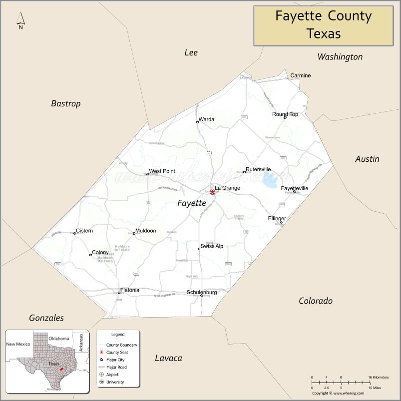
About Fayette County Map, Texas: The map showing the county boundary, county seat, major cities, highways, water bodies and neighbouring counties.
Related Texas Maps
Map of Fayette County, Texas
Fayette County is a county located in the U.S. state of Texas. It's county seat is La Grange. As per 2020 census, the population of Fayette County is 24687 people and population density is square miles. According to the United States Census Bureau, the county has a total area of 950 sq mi (2,460 km2). Fayette County was established on 1837.
Facts about Fayette County, Texas
| Country | United States |
| State | Texas |
| Region | South Central Texas |
| County Seat | La Grange |
| Named After | Marquis de Lafayette |
| Established | 1837 |
| Organized | 1838 |
| Coordinates | 29.9050° N, 96.8350° W |
| Total Area | 960 sq mi |
| Land Area | 955 sq mi |
| Water Area | 5 sq mi |
| Population (2020) | 25,346 |
| Population Rank | Moderately populated rural county |
| Major Cities | La Grange, Schulenburg, Flatonia |
| Main Industries | Agriculture, Manufacturing, Tourism, Energy |
| Major Airport | Fayette Regional Air Center (La Grange) |
| Time Zone | Central Time (UTC−06:00) |
| Known For | Painted Churches, Shiner Brewery nearby (in Lavaca Co.), Texas Czech and German heritage |
| Website | https://www.co.fayette.tx.us |
Top Attractions in Fayette County, Texas
- Monument Hill & Kreische Brewery State Historic Site (La Grange) – Scenic bluff views and historic brewery ruins.
- Fayette County Courthouse (La Grange) – Beautiful Romanesque Revival courthouse.
- Texas Quilt Museum (La Grange) – Vibrant quilt art in restored historic buildings.
- Schulenburg Painted Churches – Stunning historic churches with ornate European-style interiors.
- Stanzel Model Aircraft Museum (Schulenburg) – Exhibits on aviation history and model aircraft.
- Winedale Historical Complex (Round Top Area) – Preserved 19th-century buildings and cultural programs.
- Round Top Antiques Show – Famous antique fair drawing visitors from around the world.
- Lake Fayette – Fishing, birding, and peaceful lakeside scenery.
- Austin County Fairgrounds Annex (Fayette County Events) – Seasonal festivals and shows.
- Biegel Park (Carmine) – Small-town park with local charm and picnic space.
Cities and Towns in Fayette County, Texas
| Place | Type | Population (Census 2020) | Latitude & Longitude |
|---|---|---|---|
| La Grange (county seat) | City | 4316 | 29.9058°N, 96.8766°W |
| Schulenburg | City | 2852 | 29.6819°N, 96.9086°W |
| Flatonia | Town | 1388 | 29.6875°N, 97.1086°W |
| Fayetteville | City | 246 | 29.9050°N, 96.6733°W |
| Carmine | City | 267 | 30.1499°N, 96.6869°W |
| Ellinger | City | 203 | 29.8388°N, 96.7055°W |
| Round Top | Town | 87 | 30.0655°N, 96.6966°W |
| Plum | Census Designated Place (CDP) | 218 | 29.9344°N, 96.9336°W |
| Ledbetter | Unincorporated Community | N/A | 30.2063°N, 96.7758°W |
| West Point | Unincorporated Community | N/A | 29.9494°N, 97.0436°W |
| Warda | Unincorporated Community | N/A | 30.0716°N, 96.9083°W |
| Winchester | Unincorporated Community | N/A | 29.9549°N, 97.1575°W |
What are Major Roads and Highways in Fayette County
- Interstate 10 - east toward Houston and west toward San Antonio
- U.S. Highway 77 - north-south route through La Grange and Schulenburg
- U.S. Highway 90 - parallels Interstate 10 through southern Fayette County
- U.S. Highway 290 - connects Carmine, Ledbetter, and Austin-Houston corridor communities
- Texas State Highway 71 - major route through La Grange toward Austin and Columbus
- Texas State Highway 95 - connects Flatonia, La Grange, and Bastrop County
- Texas State Highway 159 - serves Round Top, Fayetteville, and surrounding communities
- Texas State Highway 237 - links La Grange, Round Top, and Carmine
What are Neighboring Counties of Fayette County
- Lee County (north)
- Washington County (northeast)
- Austin County (east)
- Colorado County (southeast)
- Lavaca County (south)
- Gonzales County (southwest)
- Caldwell County (west)
- Bastrop County (northwest)
Distance from Fayette County to Nearby Cities
| City | Distance (km) | Distance (mi) |
|---|---|---|
| Schulenburg | 24 | 15 |
| Flatonia | 27 | 17 |
| Fayetteville | 18 | 11 |
| Round Top | 21 | 13 |
| Columbus (Colorado County) | 42 | 26 |
| Brenham (Washington County) | 43 | 27 |
| Giddings (Lee County) | 31 | 19 |
| Smithville (Bastrop County) | 42 | 26 |
| Lockhart (Caldwell County) | 74 | 46 |
| Hallettsville (Lavaca County) | 61 | 38 |
| Bastrop (Bastrop County) | 53 | 33 |
| Austin (Travis County) | 105 | 65 |
| Houston (Harris County) | 153 | 95 |
| San Antonio (Bexar County) | 159 | 99 |
| College Station (Brazos County) | 105 | 65 |
Waterbodies in Fayette County
Colorado River, Fayette County Reservoir, Lake Fayette, East Navidad River, West Navidad River, Cummins Creek, Cedar Creek, Rabbs Creek, Buckners Creek, Williams Creek, Baylor Creek, Cedar Creek Reservoir, stock ponds, wetlands, springs, floodplain lakes, and seasonal streams
Best Golf Courses in Fayette County, Texas
| Golf Course | Location | Latitude & Longitude |
|---|---|---|
| The Falls Golf Club & Resort | New Ulm | 29.9018°N, 96.5207°W |
| Frisch Auf Valley Country Club | La Grange | 29.9248°N, 96.8694°W |
| Schulenburg Golf Course | Schulenburg | 29.6928°N, 96.9202°W |
Colleges and Universities in Fayette County, Texas
| Institution Name | Type | Level | Notable For |
|---|---|---|---|
| Blinn College | Public | Community College | Primary community college district serving most of Fayette County |
| Austin Community College | Public | Community College | Serves portions of western Fayette County through service area agreements |
| Texas A&M University | Public | University | Major regional university within commuting distance |
| Texas State University | Public | University | Regional public university serving Central Texas |
References
- U.S. Census Bureau - Fayette County QuickFacts
- Official Fayette County Website
- Texas State Historical Association - Fayette County
- Texas Almanac - Fayette County
- Blinn College
- Anderson County Map
- Andrews County Map
- Angelina County Map
- Aransas County Map
- Archer County Map
- Armstrong County Map
- Atascosa County Map
- Austin County Map
- Bailey County Map
- Bandera County Map
- Bastrop County Map
- Baylor County Map
- Bee County Map
- Bell County Map
- Bexar County Map
- Blanco County Map
- Borden County Map
- Bosque County Map
- Bowie County Map
- Brazoria County Map
- Brazos County Map
- Brewster County Map
- Briscoe County Map
- Brooks County Map
- Brown County Map
- Burleson County Map
- Burnet County Map
- Caldwell County Map
- Calhoun County Map
- Callahan County Map
- Cameron County Map
- Camp County Map
- Carson County Map
- Cass County Map
- Castro County Map
- Chambers County Map
- Cherokee County Map
- Childress County Map
- Clay County Map
- Cochran County Map
- Coke County Map
- Coleman County Map
- Collin County Map
- Collingsworth County Map
- Colorado County Map
- Comal County Map
- Comanche County Map
- Concho County Map
- Cooke County Map
- Coryell County Map
- Cottle County Map
- Crane County Map
- Crockett County Map
- Crosby County Map
- Culberson County Map
- Dallam County Map
- Dallas County Map
- Dawson County Map
- Deaf Smith County Map
- Delta County Map
- Denton County Map
- DeWitt County Map
- Dickens County Map
- Dimmit County Map
- Donley County Map
- Duval County Map
- Eastland County Map
- Ector County Map
- Edwards County Map
- Ellis County Map
- El Paso County Map
- Erath County Map
- Falls County Map
- Fannin County Map
- Fayette County Map
- Fisher County Map
- Floyd County Map
- Foard County Map
- Fort Bend County Map
- Franklin County Map
- Freestone County Map
- Frio County Map
- Gaines County Map
- Galveston County Map
- Garza County Map
- Gillespie County Map
- Glasscock County Map
- Goliad County Map
- Gonzales County Map
- Gray County Map
- Grayson County Map
- Gregg County Map
- Grimes County Map
- Guadalupe County Map
- Hale County Map
- Hall County Map
- Hamilton County Map
- Hansford County Map
- Hardeman County Map
- Hardin County Map
- Harris County Map
- Harrison County Map
- Hartley County Map
- Haskell County Map
- Hays County Map
- Hemphill County Map
- Henderson County Map
- Hidalgo County Map
- Hill County Map
- Hockley County Map
- Hood County Map
- Hopkins County Map
- Houston County Map
- Howard County Map
- Hudspeth County Map
- Hunt County Map
- Hutchinson County Map
- Irion County Map
- Jack County Map
- Jackson County Map
- Jasper County Map
- Jeff Davis County Map
- Jefferson County Map
- Jim Hogg County Map
- Jim Wells County Map
- Johnson County Map
- Jones County Map
- Karnes County Map
- Kaufman County Map
- Kendall County Map
- Kenedy County Map
- Kent County Map
- Kerr County Map
- Kimble County Map
- King County Map
- Kinney County Map
- Kleberg County Map
- Knox County Map
- Lamar County Map
- Lamb County Map
- Lampasas County Map
- La Salle County Map
- Lavaca County Map
- Lee County Map
- Leon County Map
- Liberty County Map
- Limestone County Map
- Lipscomb County Map
- Live Oak County Map
- Llano County Map
- Loving County Map
- Lubbock County Map
- Lynn County Map
- McCulloch County Map
- McLennan County Map
- McMullen County Map
- Madison County Map
- Marion County Map
- Martin County Map
- Mason County Map
- Matagorda County Map
- Maverick County Map
- Medina County Map
- Menard County Map
- Midland County Map
- Milam County Map
- Mills County Map
- Mitchell County Map
- Montague County Map
- Montgomery County Map
- Moore County Map
- Morris County Map
- Motley County Map
- Nacogdoches County Map
- Navarro County Map
- Newton County Map
- Nolan County Map
- Nueces County Map
- Ochiltree County Map
- Oldham County Map
- Orange County Map
- Palo Pinto County Map
- Panola County Map
- Parker County Map
- Parmer County Map
- Pecos County Map
- Polk County Map
- Potter County Map
- Presidio County Map
- Rains County Map
- Randall County Map
- Reagan County Map
- Real County Map
- Red River County Map
- Reeves County Map
- Refugio County Map
- Roberts County Map
- Robertson County Map
- Rockwall County Map
- Runnels County Map
- Rusk County Map
- Sabine County Map
- San Augustine County Map
- San Jacinto County Map
- San Patricio County Map
- San Saba County Map
- Schleicher County Map
- Scurry County Map
- Shackelford County Map
- Shelby County Map
- Sherman County Map
- Smith County Map
- Somervell County Map
- Starr County Map
- Stephens County Map
- Sterling County Map
- Stonewall County Map
- Sutton County Map
- Swisher County Map
- Tarrant County Map
- Taylor County Map
- Terrell County Map
- Terry County Map
- Throckmorton County Map
- Titus County Map
- Tom Green County Map
- Travis County Map
- Trinity County Map
- Tyler County Map
- Upshur County Map
- Upton County Map
- Uvalde County Map
- Val Verde County Map
- Van Zandt County Map
- Victoria County Map
- Walker County Map
- Waller County Map
- Ward County Map
- Washington County Map
- Webb County Map
- Wharton County Map
- Wheeler County Map
- Wichita County Map
- Wilbarger County Map
- Willacy County Map
- Williamson County Map
- Wilson County Map
- Winkler County Map
- Wise County Map
- Wood County Map
- Yoakum County Map
- Young County Map
- Zapata County Map
- Zavala County Map
- Alabama Counties
- Alaska boroughs
- Arizona Counties
- Arkansas Counties
- California County Map
- Colorado Counties
- Connecticut Counties
- Delaware Counties
- Florida County Map
- Georgia County Map
- Hawaii Counties
- Idaho Counties
- Illinois Counties
- Indiana Counties
- Iowa Counties
- Kansas Counties
- Kentucky Counties
- Louisiana Counties
- Maine Counties
- Maryland Counties
- Massachusetts Counties
- Michigan County Map
- Minnesota Counties
- Mississippi Counties
- Missouri Counties
- Montana Counties
- Nebraska Counties
- Nevada Counties
- New York Counties
- New Hampshire Counties
- New Jersey Counties
- New Mexico Counties
- North Carolina Counties
- North Dakota Counties
- Ohio County Map
- Oklahoma Counties
- Oregon Counties
- Pennsylvania Counties
- Rhode Island Counties
- South Carolina Counties
- South Dakota Counties
- Map of Tennessee
- Texas County Map
- Utah Counties
- Vermont Counties
- Virginia Counties
- Washington Counties
- West Virginia Counties
- Wisconsin Counties
- Wyoming Counties
References
- ^ QuickFacts: Fayette County, Texas - United States Census Bureau
- ^ United States Census Bureau - Population and Housing Data
- ^ TIGER/Line Shapefiles - United States Census Bureau
- ^ United States Geological Survey (USGS)
- ^ National Geodetic Survey (NGS), NOAA
- ^ Official Website of Fayette County, Texas
- ^ Texas Department of Transportation (TxDOT)